42:
352:
286:
393:
There are a number of places named after the river including Gryffe Road in
Kilmacolm, Gryffe Avenue in Bridge of Weir and Gryffe Crescent in Paisley, Gryffe High School – a state secondary school in Houston. There are organisations which refer to the river and its environs, such as the
301:
above the village including the
Burnbank Water, the Blacketty Water and the Mill Burn. Its main tributaries are the Green Water and the Gryfe Water, which flows through the village and begins on Little Creuch Hill to the south of Gryfe No. 1 Reservoir.
438:
661:
635:
449:
666:
339:; the water was taken near where the Linwood Moss road joins the Houston Road. The Dargavel Burn, which rises north of Kilmacolm, joins the River Gryfe near the site of the former
640:
516:
340:
383:
724:
67:
204:
719:
306:
145:
509:
367:
meaning 'rough stream'. The name is variously spelt with one 'f' or two; both spellings appear in official usage.
332:
at
Kilmacolm and Crosslee, the latter fed via a lade (millstream) which left the River Gryfe near Bridge of Weir.
379:
586:
262:
82:
310:
469:
729:
550:
502:
356:
322:
104:
555:
96:
423:
698:
484:
313:
at
Blackstone Mains Farm, having passed the north side of Quarriers Village, and the villages of
581:
127:
41:
693:
545:
314:
100:
60:
305:
It flows for approximately 16 miles (26 kilometres) to join the Black Cart Water near
713:
395:
375:
336:
270:
351:
297:
on the edge of the Duchal Woods. It is fed from a number of streams or burns on the
602:
525:
494:
190:
398:
274:
181:
607:
329:
258:
186:
131:
219:
206:
160:
147:
540:
387:
294:
285:
92:
17:
560:
318:
298:
266:
108:
72:
688:
390:
as Lord Taylor of Gryfe, of Bridge of Weir in the County of
Renfrew.
350:
284:
254:
498:
343:
after flowing in a south-east direction through ROF Bishopton.
402:
328:
The Gryfe was formerly used to supply water for powering
293:
The Gryfe emerges to the south west of the village of
374:(Strathgryffe) are mentioned in the 1169 charter of
649:
623:
616:
595:
569:
533:
235:
196:
180:
137:
123:
114:
88:
78:
66:
56:
51:
34:
428:. Edinburgh & London: Wm Blackwood & Sons.
510:
425:Scottish Land Names; their Origin and Meaning
8:
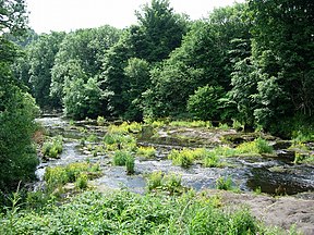
355:The River Gryffe signposted at Moss Road by
620:
517:
503:
495:
335:The river also supplied process water to
662:Renfrewshire North and West constituency
414:
269:. It gives its name to the surrounding
31:
363:The name Gryfe comes from the Gaelic
7:
460:HL Deb 31 January 1968 vol 288 c771
450:of 'Gryffe' by Renfrewshire Council
439:of 'Gryfe' by Renfrewshire Council
405:also favours the Gryffe spelling.
25:
626:Parliament of the United Kingdom
40:
636:Paisley and Renfrewshire North
198: • coordinates
139: • coordinates
1:
422:Maxwell, Sir Herbert (1894).
307:Glasgow International Airport
115:Physical characteristics
470:of 'Gryffe' used by the BBC
746:
341:Georgetown railway station
679:
176:
119:
39:
380:Independent Labour Party
667:West of Scotland region
261:, running through the
239:26 km (16 mi)
725:Rivers of Renfrewshire
587:County of Renfrewshire
360:
290:
684:Neighbouring regions:
489:Gazetteer of Scotland
354:
288:
257:and tributary of the
161:55.908000°N 4.74500°W
720:Rivers of Inverclyde
603:Renfrewshire Council
220:55.87000°N 4.46000°W
699:West Dunbartonshire
652:Scottish Parliament
528:- The Gryffe Valley
289:The Gryfe Reservoir
216: /
166:55.908000; -4.74500
157: /
68:Constituent country
608:Inverclyde Council
556:Quarrier's Village
534:Towns and villages
361:
291:
225:55.87000; -4.46000
97:Quarrier's Village
707:
706:
675:
674:
263:County of Renfrew
243:
242:
29:River in Scotland
16:(Redirected from
737:
655:
629:
621:
596:Local government
582:Gryffe Reservoir
519:
512:
505:
496:
472:
467:
461:
458:
452:
447:
441:
436:
430:
429:
419:
370:The churches of
273:, also known as
259:Black Cart Water
231:
230:
228:
227:
226:
221:
217:
214:
213:
212:
209:
187:Black Cart Water
172:
171:
169:
168:
167:
162:
158:
155:
154:
153:
150:
140:
128:Gryffe Reservoir
46:The River Gryffe
44:
32:
21:
745:
744:
740:
739:
738:
736:
735:
734:
710:
709:
708:
703:
671:
650:
645:
624:
612:
591:
565:
529:
523:
481:
476:
475:
468:
464:
459:
455:
448:
444:
437:
433:
421:
420:
416:
411:
349:
283:
265:in the west of
224:
222:
218:
215:
210:
207:
205:
203:
202:
199:
165:
163:
159:
156:
151:
148:
146:
144:
143:
138:
47:
30:
23:
22:
15:
12:
11:
5:
743:
741:
733:
732:
727:
722:
712:
711:
705:
704:
702:
701:
696:
694:North Ayrshire
691:
686:
680:
677:
676:
673:
672:
670:
669:
664:
658:
656:
647:
646:
644:
643:
638:
632:
630:
618:
617:Representation
614:
613:
611:
610:
605:
599:
597:
593:
592:
590:
589:
584:
579:
573:
571:
567:
566:
564:
563:
558:
553:
548:
546:Bridge of Weir
543:
537:
535:
531:
530:
524:
522:
521:
514:
507:
499:
493:
492:
480:
479:External links
477:
474:
473:
462:
453:
442:
431:
413:
412:
410:
407:
348:
345:
315:Bridge of Weir
282:
279:
241:
240:
237:
233:
232:
200:
197:
194:
193:
184:
178:
177:
174:
173:
141:
135:
134:
125:
121:
120:
117:
116:
112:
111:
101:Bridge of Weir
90:
89:Towns/villages
86:
85:
80:
76:
75:
70:
64:
63:
61:United Kingdom
58:
54:
53:
49:
48:
45:
37:
36:
28:
24:
14:
13:
10:
9:
6:
4:
3:
2:
742:
731:
728:
726:
723:
721:
718:
717:
715:
700:
697:
695:
692:
690:
687:
685:
682:
681:
678:
668:
665:
663:
660:
659:
657:
653:
648:
642:
639:
637:
634:
633:
631:
627:
622:
619:
615:
609:
606:
604:
601:
600:
598:
594:
588:
585:
583:
580:
578:
575:
574:
572:
568:
562:
559:
557:
554:
552:
549:
547:
544:
542:
539:
538:
536:
532:
527:
520:
515:
513:
508:
506:
501:
500:
497:
490:
486:
483:
482:
478:
471:
466:
463:
457:
454:
451:
446:
443:
440:
435:
432:
427:
426:
418:
415:
408:
406:
404:
400:
397:
396:Gryffe Valley
391:
389:
385:
384:Thomas Taylor
381:
377:
376:Paisley Abbey
373:
368:
366:
358:
353:
346:
344:
342:
338:
337:ROF Bishopton
333:
331:
326:
324:
320:
316:
312:
308:
303:
300:
296:
287:
280:
278:
276:
272:
271:Gryffe Valley
268:
264:
260:
256:
252:
248:
238:
234:
229:
201:
195:
192:
188:
185:
183:
179:
175:
170:
142:
136:
133:
129:
126:
122:
118:
113:
110:
106:
102:
98:
94:
91:
87:
84:
81:
77:
74:
71:
69:
65:
62:
59:
55:
50:
43:
38:
33:
27:
19:
730:Strathgryffe
683:
651:
625:
577:River Gryffe
576:
526:Strathgryffe
488:
465:
456:
445:
434:
424:
417:
392:
371:
369:
364:
362:
334:
327:
304:
292:
250:
246:
244:
191:Renfrewshire
149:55°54′28.8″N
83:Renfrewshire
26:
18:River Gryffe
485:River Gryfe
399:Rotary Club
386:was made a
382:politician
378:. In 1968,
330:water mills
311:M8 motorway
309:beside the
275:Strathgryfe
247:River Gryfe
223: /
164: /
714:Categories
641:Inverclyde
409:References
208:55°52′12″N
132:Inverclyde
570:Geography
541:Kilmacolm
388:life peer
295:Kilmacolm
211:4°27′36″W
152:4°44′42″W
93:Kilmacolm
561:Crosslee
372:Stragrif
319:Crosslee
267:Scotland
109:Crosslee
73:Scotland
52:Location
689:Glasgow
551:Houston
487:at the
357:Houston
323:Houston
253:) is a
105:Houston
57:Country
401:. The
251:Gryffe
236:Length
124:Source
79:County
365:garbh
299:moors
255:river
182:Mouth
35:Gryfe
347:Name
321:and
281:Flow
249:(or
245:The
403:BBC
716::
325:.
317:,
277:.
189:,
130:,
107:,
103:,
99:,
95:,
654::
628::
518:e
511:t
504:v
491:.
359:.
20:)
Text is available under the Creative Commons Attribution-ShareAlike License. Additional terms may apply.