42:
534:
315:
The
Environment Agency measures the water quality of the river systems in England. Each is given an overall ecological status, which may be one of five levels: high, good, moderate, poor and bad. There are several components that are used to determine this, including biological status, which looks at
294:
Although
Tilshead village appears to be named from the river, the opposite applies. The village name was first used in the 16th century, and comes from older names based on "Theodwulf's hide" (recorded in
935:
915:
930:
945:
980:
950:
454:
324:
and fish. Chemical status, which compares the concentrations of various chemicals against known safe concentrations, is rated good or fail.
965:
940:
41:
756:
587:
195:
995:
303:). The river was called the Winterbourne until around the start of the 20th century, when the name River Till began to be used on
955:
597:
126:
778:
1016:
990:
975:
970:
925:
920:
838:
284:
20:
985:
425:
24:
399:
551:
783:
580:
538:
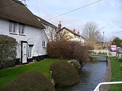
889:
696:
686:
248:
in the
English county of Wiltshire. It flows for about 14 km (9 miles) south and south-east, through
884:
818:
798:
711:
280:
269:
253:
177:
960:
905:
788:
743:
523:
618:
573:
283:, flowing only in winter and early spring. The whole length of the Till has been designated as a
261:
910:
748:
623:
497:
646:
265:
706:
304:
245:
533:
288:
63:
1010:
813:
483:
296:
858:
853:
833:
823:
803:
793:
524:"Glossary (see Biological quality element; Chemical status; and Ecological status)"
317:
478:
565:
868:
808:
273:
162:
773:
738:
733:
691:
656:
321:
210:
197:
141:
128:
848:
828:
717:
676:
666:
603:
496:
Baggs, A.P.; Freeman, Jane; Stevenson, Janet H (1995). Crowley, D.A. (ed.).
249:
181:
83:
498:"Victoria County History: Wiltshire: Vol 15 pp263-275 – Parishes: Tilshead"
843:
728:
701:
681:
641:
257:
241:
112:
47:
723:
671:
661:
73:
651:
569:
537:
Text was copied from this source, which is available under an
898:
877:
766:
632:
611:
226:
187:
171:
161:
118:
106:
98:
89:
79:
69:
59:
54:
34:
581:
8:
291:which provides habitat for fish and snails.
588:
574:
566:
377:127.785 km (49.338 sq mi)
327:Water quality of the River Till in 2019:
329:
530:. Environment Agency. 17 February 2016.
391:
31:
7:
757:List of civil parishes in Wiltshire
285:Site of Special Scientific Interest
23:. For the Lincolnshire river, see
19:For the Northumberland river, see
14:
279:The upper part of the river is a
532:
40:
931:Population of major settlements
426:"Notification: River Till SSSI"
374:13.993 km (8.695 mi)
316:the quantity and varieties of
189: • coordinates
120: • coordinates
1:
287:, as its vegetation includes
90:Physical characteristics
916:Parliamentary constituencies
539:Open Government Licence v3.0
173: • location
108: • location
16:River in Wiltshire, England
1033:
951:Grade II* listed buildings
21:River Till, Northumberland
18:
157:
94:
39:
946:Grade I listed buildings
25:River Till, Lincolnshire
556:Catchment Data Explorer
552:"Till (Hampshire Avon)"
528:Catchment Data Explorer
404:Catchment Data Explorer
400:"Till (Hampshire Avon)"
504:. University of London
502:British History Online
362:Till (Hampshire Avon)
712:Royal Wootton Bassett
558:. Environment Agency.
70:Country within the UK
541:. © Crown copyright.
406:. Environment Agency
211:51.13583°N 1.90194°W
142:51.23028°N 1.95583°W
1017:Rivers of Wiltshire
956:Scheduled monuments
635:(cities in italics)
612:Unitary authorities
207: /
138: /
981:Deputy Lieutenants
262:Winterbourne Stoke
216:51.13583; -1.90194
147:51.23028; -1.95583
1004:
1003:
890:Wilts & Berks
633:Major settlements
624:Wiltshire Council
598:Ceremonial county
455:"River Till SSSI"
383:
382:
234:
233:
1024:
976:Lords Lieutenant
647:Bradford-on-Avon
606:
600:
590:
583:
576:
567:
560:
559:
548:
542:
536:
531:
520:
514:
513:
511:
509:
493:
487:
476:
470:
469:
467:
465:
451:
445:
444:
442:
440:
430:
422:
416:
415:
413:
411:
396:
330:
266:Berwick St James
222:
221:
219:
218:
217:
212:
208:
205:
204:
203:
200:
153:
152:
150:
149:
148:
143:
139:
136:
135:
134:
131:
121:
109:
44:
32:
1032:
1031:
1027:
1026:
1025:
1023:
1022:
1021:
1007:
1006:
1005:
1000:
966:Monastic houses
921:Local elections
894:
885:Kennet and Avon
873:
762:
751:
634:
628:
607:
602:
596:
594:
564:
563:
550:
549:
545:
522:
521:
517:
507:
505:
495:
494:
490:
477:
473:
463:
461:
459:Natural England
453:
452:
448:
438:
436:
433:Natural England
428:
424:
423:
419:
409:
407:
398:
397:
393:
388:
347:
342:
337:
313:
305:Ordnance Survey
246:Salisbury Plain
215:
213:
209:
206:
201:
198:
196:
194:
193:
190:
174:
146:
144:
140:
137:
132:
129:
127:
125:
124:
119:
107:
50:
28:
17:
12:
11:
5:
1030:
1028:
1020:
1019:
1009:
1008:
1002:
1001:
999:
998:
993:
988:
983:
978:
973:
968:
963:
958:
953:
948:
943:
941:Country houses
938:
933:
928:
923:
918:
913:
908:
902:
900:
896:
895:
893:
892:
887:
881:
879:
875:
874:
872:
871:
866:
861:
856:
851:
846:
841:
836:
831:
826:
821:
819:Hampshire Avon
816:
814:Fonthill Brook
811:
806:
801:
796:
791:
786:
781:
776:
770:
768:
764:
763:
761:
760:
746:
741:
736:
731:
726:
721:
714:
709:
704:
699:
694:
689:
684:
679:
674:
669:
664:
659:
654:
649:
644:
638:
636:
630:
629:
627:
626:
621:
615:
613:
609:
608:
595:
593:
592:
585:
578:
570:
562:
561:
543:
515:
488:
471:
446:
417:
390:
389:
387:
384:
381:
380:
378:
375:
372:
369:
366:
363:
359:
358:
355:
352:
349:
344:
339:
334:
312:
309:
289:water crowfoot
272:, to join the
232:
231:
228:
224:
223:
191:
188:
185:
184:
175:
172:
169:
168:
165:
159:
158:
155:
154:
122:
116:
115:
110:
104:
103:
100:
96:
95:
92:
91:
87:
86:
81:
77:
76:
71:
67:
66:
64:United Kingdom
61:
57:
56:
52:
51:
46:River Till at
45:
37:
36:
15:
13:
10:
9:
6:
4:
3:
2:
1029:
1018:
1015:
1014:
1012:
997:
994:
992:
989:
987:
986:High Sheriffs
984:
982:
979:
977:
974:
972:
969:
967:
964:
962:
959:
957:
954:
952:
949:
947:
944:
942:
939:
937:
934:
932:
929:
927:
924:
922:
919:
917:
914:
912:
909:
907:
904:
903:
901:
897:
891:
888:
886:
883:
882:
880:
876:
870:
867:
865:
862:
860:
857:
855:
852:
850:
847:
845:
842:
840:
837:
835:
832:
830:
827:
825:
822:
820:
817:
815:
812:
810:
807:
805:
802:
800:
797:
795:
792:
790:
787:
785:
782:
780:
777:
775:
772:
771:
769:
765:
759:
758:
754:
750:
747:
745:
742:
740:
737:
735:
732:
730:
727:
725:
722:
720:
719:
715:
713:
710:
708:
705:
703:
700:
698:
695:
693:
690:
688:
685:
683:
680:
678:
675:
673:
670:
668:
665:
663:
660:
658:
655:
653:
650:
648:
645:
643:
640:
639:
637:
631:
625:
622:
620:
617:
616:
614:
610:
605:
599:
591:
586:
584:
579:
577:
572:
571:
568:
557:
553:
547:
544:
540:
535:
529:
525:
519:
516:
503:
499:
492:
489:
486:
485:
484:Domesday Book
480:
475:
472:
460:
456:
450:
447:
435:. August 2000
434:
427:
421:
418:
405:
401:
395:
392:
385:
379:
376:
373:
370:
367:
364:
361:
360:
356:
353:
350:
345:
340:
335:
332:
331:
328:
325:
323:
319:
318:invertebrates
311:Water quality
310:
308:
306:
302:
298:
297:Domesday Book
292:
290:
286:
282:
277:
275:
271:
267:
263:
259:
255:
251:
247:
243:
239:
229:
225:
220:
192:
186:
183:
179:
176:
170:
166:
164:
160:
156:
151:
123:
117:
114:
111:
105:
101:
97:
93:
88:
85:
82:
78:
75:
72:
68:
65:
62:
58:
53:
49:
43:
38:
33:
30:
26:
22:
996:Hill figures
863:
854:Tetbury Avon
789:Bristol Avon
755:
752:
716:
555:
546:
527:
518:
506:. Retrieved
501:
491:
482:
474:
462:. Retrieved
458:
449:
437:. Retrieved
432:
420:
408:. Retrieved
403:
394:
326:
314:
300:
293:
281:winterbourne
278:
237:
235:
29:
697:Marlborough
687:Ludgershall
322:angiosperms
274:River Wylye
240:rises near
214: /
145: /
779:Blackwater
739:Warminster
734:Trowbridge
692:Malmesbury
657:Chippenham
386:References
336:Ecological
301:Tidolthide
270:Stapleford
254:Maddington
238:River Till
199:51°08′09″N
178:Stapleford
130:51°13′49″N
35:River Till
839:Nine Mile
753:See also:
718:Salisbury
677:Highworth
667:Cricklade
604:Wiltshire
371:Moderate
354:Catchment
250:Orcheston
202:1°54′07″W
182:Wiltshire
133:1°57′21″W
84:Wiltshire
1011:Category
744:Westbury
729:Tidworth
702:Melksham
682:Larkhill
642:Amesbury
479:Tilshead
357:Channel
341:Chemical
258:Shrewton
242:Tilshead
113:Tilshead
80:Counties
55:Location
48:Shrewton
991:Museums
971:Schools
961:History
906:Economy
724:Swindon
672:Devizes
662:Corsham
619:Swindon
481:in the
346:Overall
333:Section
74:England
60:Country
926:Places
899:Topics
878:Canals
859:Thames
834:Nadder
824:Kennet
804:Damson
794:Chalke
784:Bourne
767:Rivers
749:Wilton
508:20 May
464:20 May
439:20 May
410:20 May
351:Length
348:Status
343:Status
338:Status
307:maps.
227:Length
167:
102:
99:Source
936:SSSIs
869:Wylye
809:Ebble
652:Calne
429:(PDF)
368:Fail
365:Good
163:Mouth
911:Flag
864:Till
799:Cole
774:Biss
707:Mere
510:2021
466:2021
441:2021
412:2021
268:and
236:The
230:14km
849:Sem
829:Key
601:of
299:as
244:on
1013::
844:Og
554:.
526:.
500:.
457:.
431:.
402:.
320:,
276:.
264:,
260:,
256:,
252:,
180:,
589:e
582:t
575:v
512:.
468:.
443:.
414:.
27:.
Text is available under the Creative Commons Attribution-ShareAlike License. Additional terms may apply.