31:
489:
328:, "… and on his expressed desire for some beverage to drink Mr Bloom in view of the hour it was and there being no pump of Vartry water available for their ablutions let alone drinking purposes...” or “Power. Particular about his drink. Flaw in the glass, fresh Vartry water.” Likewise, in
269:
formed along the coastline cutting off the Vartry from its original egress. This sand spit is called The
Murrough/Murragh and it carries the Dublin to Wicklow coastal railway line built in the 1860s. Broad Lough drains southwards into the
274:
through
Wicklow town centre and harbour. The name of this stretch of water (approximately 1.5 km in length) is disputed. It is variously called the River Leitrim, the Broad Lough Estuary and the River Vartry.
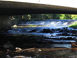
303:. The dam, accompanying waterworks, and a pipe tunnel through a part of the Wicklow Mountains, were completed in 1865, providing the first clean mass source of water for
1010:
542:
265:
town (at its closest point) and approximately 4 km north of
Parnell Bridge (at its furthest point). This lake and surrounding wetlands evolved when a
353:
1049:
535:
471:
803:
891:
528:
310:
The Vartry
Reservoir and Waterworks still supply some 200,000 homes, providing 40% of all of Dublin's water needs.
876:
560:
439:"Broad Lough - Sampling fish for the Water Framework Directive". Central and Regional Fisheries Board. Ireland.
247:
36:
254:. From there it passes the Nun's Cross Bridge (dating from the 18th century) on through Ashford, under the
958:
938:
933:
251:
638:
287:
the place where St. Patrick landed was at
Inverdea, the mouth of the river Vartry in County Wicklow.
998:
698:
674:
191:
295:
In 1861 Parliament passed the Dublin
Waterworks Act creating a project to dam the River Vartry in
788:
382:
255:
839:
633:
551:
515:
444:
994:
749:
657:
646:
300:
239:
152:
261:
Broad Lough is a narrow lake which lies approximately 1 km north of
Parnell Bridge in
457:
324:
418:
831:
330:
243:
187:
179:
99:
67:
1043:
968:
925:
906:
725:
589:
30:
973:
963:
953:
943:
911:
854:
844:
808:
783:
754:
744:
738:
713:
708:
693:
688:
652:
886:
881:
871:
849:
798:
759:
731:
720:
703:
682:
669:
628:
623:
596:
475:
319:
110:
978:
948:
901:
866:
860:
818:
813:
775:
664:
582:
575:
246:. Passing through a Dublin municipal reservoir complex, it flows east towards
1025:
1012:
258:
and continues eastwards into Broad Lough, which flows towards
Wicklow town.
921:
896:
793:
615:
603:
296:
271:
266:
215:
125:
219:
386:
370:
262:
223:
129:
334:, Joyce refers to the reservoir, writing “Water, water, darty water!”
304:
195:
520:
400:
222:
at
Glasnamullen. Similar placenames are found at Forther, Forthar,
524:
206:
The river first appears in 12th-century records with the name
170:
161:
375:
The
Journal of the Royal Society of Antiquaries of Ireland
474:. Heritage Office Wicklow County Council. Archived from
502:
McHugh, Ronald. Annotations to Finnegans Wake. Pg. 521
354:
Dublin on a knife-edge when it comes to water supply
167:
164:
158:
920:
829:
773:
613:
567:
155:
135:
119:
109:
92:
84:
75:
55:
43:
23:
993:indicate rivers which are partially or wholly in
371:"Calendar of the "Liber Niger Alani" (Continued)"
285:The Life of St. Patrick and His Place in History
218:term meaning "fortress", perhaps referring to a
194:, and an important water source for the city of
318:There are several references to the Vartry in
307:, replacing water obtained from the canals.
536:
8:
349:
347:
59:
543:
529:
521:
250:under Annagolan Bridge, and down through
343:
453:
442:
434:
432:
20:
214:. This is believed to derive from an
7:
997:, with the rest being wholly in the
419:"eDIL - Irish Language Dictionary"
14:
401:"Abhainn Fheartraí/Vartry River"
151:
29:
18:River in County Wicklow, Ireland
1:
76:Physical characteristics
121: • location
94: • location
1066:
139:33 kilometres (21 mi)
987:
558:
105:
80:
28:
1050:Rivers of County Wicklow
472:"Wicklow's Living Coast"
226:and Ferter in Scotland.
369:Stokes, G. T. (1897).
183:
60:
279:Historical references
242:mountain in northern
35:River Vartry through
1026:53.05972°N 6.20667°W
234:The Vartry rises in
1022: /
999:Republic of Ireland
1031:53.05972; -6.20667
478:on 11 August 2013.
389:– via JSTOR.
51:, "mound, tumulus"
1005:
1004:
804:The Three Sisters
552:Rivers of Ireland
516:Rivers of Ireland
452:Missing or empty
291:City water supply
184:Abhainn Fheartraí
143:
142:
61:Abhainn Fheartraí
1057:
1037:
1036:
1034:
1033:
1032:
1027:
1023:
1020:
1019:
1018:
1015:
995:Northern Ireland
750:Shanganagh River
545:
538:
531:
522:
503:
500:
494:
493:
486:
480:
479:
468:
462:
461:
455:
450:
448:
440:
436:
427:
426:
415:
409:
408:
397:
391:
390:
366:
360:
351:
301:Vartry Reservoir
240:Great Sugar Loaf
186:) is a river in
177:
176:
173:
172:
169:
166:
163:
160:
157:
95:
71:
63:
33:
21:
1065:
1064:
1060:
1059:
1058:
1056:
1055:
1054:
1040:
1039:
1030:
1028:
1024:
1021:
1016:
1013:
1011:
1009:
1008:
1006:
1001:
989:River names in
983:
916:
830:Flowing to the
825:
774:Flowing to the
769:
614:Flowing to the
609:
563:
554:
549:
512:
507:
506:
501:
497:
488:
487:
483:
470:
469:
465:
451:
441:
438:
437:
430:
417:
416:
412:
399:
398:
394:
368:
367:
363:
352:
345:
340:
316:
314:Popular culture
293:
281:
232:
204:
154:
150:
122:
93:
65:
39:
19:
12:
11:
5:
1063:
1061:
1053:
1052:
1042:
1041:
1003:
1002:
988:
985:
984:
982:
981:
976:
971:
966:
961:
956:
951:
946:
941:
936:
930:
928:
918:
917:
915:
914:
909:
904:
899:
894:
889:
884:
879:
874:
869:
864:
857:
852:
847:
842:
836:
834:
827:
826:
824:
823:
822:
821:
816:
811:
801:
796:
791:
786:
780:
778:
771:
770:
768:
767:
762:
757:
752:
747:
742:
735:
728:
723:
718:
717:
716:
711:
706:
701:
696:
686:
679:
678:
677:
667:
662:
661:
660:
650:
643:
642:
641:
631:
626:
620:
618:
611:
610:
608:
607:
600:
593:
586:
579:
571:
569:
565:
564:
559:
556:
555:
550:
548:
547:
540:
533:
525:
519:
518:
511:
508:
505:
504:
495:
492:. Google Maps.
481:
463:
428:
410:
392:
381:(4): 404–422.
361:
359:March 10, 2018
342:
341:
339:
336:
331:Finnegans Wake
315:
312:
292:
289:
280:
277:
244:County Wicklow
231:
228:
203:
200:
188:County Wicklow
141:
140:
137:
133:
132:
123:
120:
117:
116:
113:
107:
106:
103:
102:
100:County Wicklow
96:
90:
89:
86:
82:
81:
78:
77:
73:
72:
57:
53:
52:
45:
41:
40:
34:
26:
25:
17:
13:
10:
9:
6:
4:
3:
2:
1062:
1051:
1048:
1047:
1045:
1038:
1035:
1000:
996:
992:
986:
980:
977:
975:
972:
970:
969:Mulkear River
967:
965:
962:
960:
957:
955:
952:
950:
947:
945:
942:
940:
937:
935:
932:
931:
929:
927:
923:
919:
913:
910:
908:
905:
903:
900:
898:
895:
893:
890:
888:
885:
883:
880:
878:
875:
873:
870:
868:
865:
863:
862:
858:
856:
853:
851:
848:
846:
843:
841:
838:
837:
835:
833:
828:
820:
817:
815:
812:
810:
807:
806:
805:
802:
800:
797:
795:
792:
790:
787:
785:
782:
781:
779:
777:
772:
766:
763:
761:
758:
756:
753:
751:
748:
746:
743:
741:
740:
736:
734:
733:
729:
727:
724:
722:
719:
715:
712:
710:
707:
705:
702:
700:
697:
695:
692:
691:
690:
687:
685:
684:
680:
676:
673:
672:
671:
668:
666:
663:
659:
656:
655:
654:
651:
649:
648:
644:
640:
637:
636:
635:
632:
630:
627:
625:
622:
621:
619:
617:
612:
606:
605:
601:
599:
598:
594:
592:
591:
587:
585:
584:
580:
578:
577:
573:
572:
570:
568:Flowing north
566:
562:
557:
553:
546:
541:
539:
534:
532:
527:
526:
523:
517:
514:
513:
509:
499:
496:
491:
490:"Google Maps"
485:
482:
477:
473:
467:
464:
459:
446:
435:
433:
429:
424:
420:
414:
411:
406:
402:
396:
393:
388:
384:
380:
376:
372:
365:
362:
358:
355:
350:
348:
344:
337:
335:
333:
332:
327:
326:
321:
313:
311:
308:
306:
302:
298:
290:
288:
286:
283:According to
278:
276:
273:
268:
264:
259:
257:
253:
249:
245:
241:
237:
229:
227:
225:
221:
217:
213:
209:
201:
199:
197:
193:
189:
185:
181:
175:
148:
138:
134:
131:
127:
124:
118:
114:
112:
108:
104:
101:
97:
91:
87:
83:
79:
74:
69:
62:
58:
54:
50:
46:
42:
38:
32:
27:
22:
16:
1007:
990:
974:Nenagh River
859:
764:
737:
730:
681:
645:
602:
595:
588:
581:
574:
498:
484:
476:the original
466:
422:
413:
404:
395:
378:
374:
364:
356:
329:
323:
317:
309:
299:to form the
294:
284:
282:
260:
252:Devil's Glen
235:
233:
211:
207:
205:
147:River Vartry
146:
144:
98:Calary Bog,
48:
24:River Vartry
15:
1029: /
939:Boyle River
934:Abbey River
922:Tributaries
840:Ballisodare
634:Broadmeadow
357:Irish Times
320:James Joyce
56:Native name
1014:53°03′35″N
789:Blackwater
776:Celtic Sea
658:Glencullen
647:Castletown
454:|url=
423:www.dil.ie
405:Logainm.ie
338:References
238:under the
236:Calary Bog
47:Old Irish
1017:6°12′24″W
616:Irish Sea
297:Roundwood
272:Irish Sea
267:sand spit
216:Old Irish
126:Irish Sea
44:Etymology
1044:Category
832:Atlantic
510:See also
445:cite web
387:25508440
256:N11 road
220:ringfort
991:italics
926:Shannon
924:of the
907:Shannon
726:Naniken
590:Faughan
325:Ulysses
263:Wicklow
248:Ashford
224:Fortriu
192:Ireland
130:Wicklow
37:Ashford
964:Maigue
954:Fergus
944:Brosna
912:Swilly
855:Corrib
845:Caragh
809:Barrow
784:Bandon
765:Vartry
755:Slaney
745:Santry
739:Quoile
714:Dodder
709:Poddle
694:Morell
689:Liffey
653:Dargle
385:
305:Dublin
230:Course
212:Fortir
208:Fertir
196:Dublin
136:Length
115:
88:
85:Source
64:
892:Maine
887:Ferta
882:Laune
872:Feale
850:Clare
799:Mahon
760:Tolka
732:Newry
721:Mayne
704:Camac
683:Lagan
670:Glyde
629:Boyne
624:Avoca
597:Foyle
383:JSTOR
180:Irish
111:Mouth
68:Irish
979:Suck
959:Inny
949:Deel
902:Robe
877:Inny
867:Eske
861:Erne
819:Suir
814:Nore
665:Fane
639:Ward
583:Bush
576:Bann
561:List
458:help
202:Name
145:The
49:fert
897:Moy
794:Lee
699:Rye
675:Dee
604:Roe
322:'s
210:or
162:ɑːr
128:at
1046::
449::
447:}}
443:{{
431:^
421:.
403:.
377:.
373:.
346:^
198:.
190:,
182::
178:;
171:iː
544:e
537:t
530:v
460:)
456:(
425:.
407:.
379:7
174:/
168:r
165:t
159:v
156:ˈ
153:/
149:(
70:)
66:(
Text is available under the Creative Commons Attribution-ShareAlike License. Additional terms may apply.