44:
488:
342:
At its mouth, the Rivière du Loup pours over a long ledge (at low tide) in the "Cayes to
Carrier Bay" which is bordered on the north side by the Pointe-de-Rivière-du-Loup. From Malin Rock, this edge advances towards the southwest in the
362:. The Channel "Pot à l'Eau-de-Vie" (English: "Pot of stream water") separates the island and the southeast coast of St. Lawrence River. The Estuary Islands Wildlife Reserve (
141:
317:
217:
447:
283:
244:
252:
508:
426:
67:
17:
264:
299:
474:
469:
328:
309:
464:
492:
359:
275:
213:
513:
304:
294:
268:
459:
323:
260:
248:
205:
115:
414:
289:
344:
333:
209:
127:
358:(English: White Island), located 10 km (6 miles) offshore and part of the municipality of
274:
The Rivière du Loup flows to the north over 101.3 kilometers (63 miles), coursing through the
221:
383:
239:
The Rivière du Loup (English: "river of the Wolf") has its source in Saint-Pierre Lake (
502:
228:
347:
over a length of 1.6 km (1 mile), including the end where a marina is fitted.
259:. This lake is located 36.5 km (23 miles) east of the southeast coast of the
43:
256:
110:
156:
143:
386:
and may have come from a native tribe known as "Les Loups" or from the many
487:
387:
201:
72:
197:
267:
and 20 km (12 miles) south-west of the village center of
263:, 20 km (12 miles) southeast of the village center of
48:
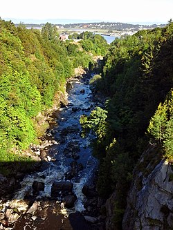
Gorge of the
Riviere du Loup at the city of Rivière-du-Loup
182:
172:
133:
121:
109:
95:
87:
78:
66:
58:
53:
30:
243:) in the geographic township of Painchaud in the
320:: municipalities (starting from the upstream)
286:: municipalities (starting from the upstream)
204:, Canada, which empties on the south shore of
350:The river's mouth is located in front of the
8:
366:) was built on a set of islands between the
409:
407:
255:(English: Controlled Harvesting Zone) of
403:
364:Réserve faunique des Îles de l'Estuaire
245:Kamouraska Regional County Municipality
27:
382:The river's name means Wolf River in
7:
394:, once found at the river's mouth.
354:(English: Island of Hare) and the
231:plant on the river near the city.
220:, in the administrative region of
14:
427:Commission de toponymie du Québec
417:Banque de noms de lieux du Québec
486:
42:
18:Rivière-du-Loup (disambiguation)
276:regional county municipalities
135: • coordinates
1:
310:Saint-Alexandre-de-Kamouraska
253:Zone d'exploitation contrôlée
79:Physical characteristics
214:regional county municipality
186:101.3 km (62.9 mi)
174: • elevation
97: • elevation
509:Rivers of Bas-Saint-Laurent
475:GPX (secondary coordinates)
300:Sainte-Hélène-de-Kamouraska
123: • location
530:
305:Saint-Joseph-de-Kamouraska
101:479 m (1,572 ft)
15:
470:GPX (primary coordinates)
445:Map all coordinates using
419:: Reference number 66892"
360:Saint-André-de-Kamouraska
295:Saint-Bruno-de-Kamouraska
265:Saint-Bruno-of-Kamouraska
105:
83:
41:
34:
453:Download coordinates as:
212:, which is part of the
25:River in Quebec, Canada
465:GPX (all coordinates)
390:, known in French as
329:Notre-Dame-du-Portage
495:at Wikimedia Commons
423:toponymie.gouv.qc.ca
261:Gulf of St. Lawrence
249:Notre Dame Mountains
206:Saint Lawrence River
178:0 ft (0 m)
116:Saint Lawrence River
16:For other uses, see
157:47.8519°N 69.5544°W
153: /
372:Pot à l'Eau-de-Vie
345:St. Lawrence River
247:, which is in the
491:Media related to
222:Bas-Saint-Laurent
190:
189:
162:47.8519; -69.5544
91:Saint-Pierre Lake
521:
490:
431:
430:
411:
370:and the channel
241:Lac Saint-Pierre
168:
167:
165:
164:
163:
158:
154:
151:
150:
149:
146:
98:
46:
36:
28:
529:
528:
524:
523:
522:
520:
519:
518:
514:Rivière-du-Loup
499:
498:
493:Rivière du Loup
483:
482:
481:
480:
479:
440:
435:
434:
413:
412:
405:
400:
380:
368:Île aux Lièvres
352:Île aux Lièvres
334:Rivière-du-Loup
318:Rivière-du-Loup
237:
218:Rivière-du-Loup
210:Rivière-du-Loup
208:at the city of
194:Rivière du Loup
175:
161:
159:
155:
152:
147:
144:
142:
140:
139:
136:
128:Rivière-du-Loup
124:
96:
49:
32:
31:Rivière du Loup
26:
21:
12:
11:
5:
527:
525:
517:
516:
511:
501:
500:
497:
496:
478:
477:
472:
467:
462:
456:
450:
443:
442:
441:
439:
438:External links
436:
433:
432:
402:
401:
399:
396:
379:
376:
340:
339:
338:
337:
331:
326:
314:
313:
312:
307:
302:
297:
292:
269:Saint-Athanase
236:
233:
188:
187:
184:
180:
179:
176:
173:
170:
169:
137:
134:
131:
130:
125:
122:
119:
118:
113:
107:
106:
103:
102:
99:
93:
92:
89:
85:
84:
81:
80:
76:
75:
70:
64:
63:
60:
56:
55:
51:
50:
47:
39:
38:
24:
13:
10:
9:
6:
4:
3:
2:
526:
515:
512:
510:
507:
506:
504:
494:
489:
485:
484:
476:
473:
471:
468:
466:
463:
461:
458:
457:
455:
454:
449:
448:OpenStreetMap
446:
437:
428:
425:(in French).
424:
420:
418:
410:
408:
404:
397:
395:
393:
389:
385:
377:
375:
373:
369:
365:
361:
357:
353:
348:
346:
335:
332:
330:
327:
325:
324:Saint-Antonin
322:
321:
319:
315:
311:
308:
306:
303:
301:
298:
296:
293:
291:
288:
287:
285:
281:
280:
279:
277:
272:
270:
266:
262:
258:
254:
250:
246:
242:
234:
232:
230:
229:hydroelectric
225:
223:
219:
215:
211:
207:
203:
199:
195:
185:
181:
177:
171:
166:
138:
132:
129:
126:
120:
117:
114:
112:
108:
104:
100:
94:
90:
86:
82:
77:
74:
71:
69:
65:
61:
57:
52:
45:
40:
29:
23:
19:
452:
451:
444:
422:
416:
391:
381:
371:
367:
363:
355:
351:
349:
341:
273:
240:
238:
226:
193:
191:
22:
356:Île Blanche
290:Mont-Carmel
257:Zec Chapais
227:There is a
200:in eastern
160: /
503:Categories
398:References
392:loup marin
284:Kamouraska
148:69°33′16″W
145:47°51′07″N
35:Wolf River
33:(English:
235:Geography
378:Toponymy
251:and the
68:Province
54:Location
59:Country
384:French
216:(RCM)
202:Quebec
183:Length
88:Source
73:Quebec
62:Canada
388:seals
336:city.
198:river
196:is a
111:Mouth
316:MRC
282:MRC
278:of:
192:The
460:KML
505::
421:.
406:^
374:.
271:.
224:.
429:.
415:"
37:)
20:.
Text is available under the Creative Commons Attribution-ShareAlike License. Additional terms may apply.