46:
288:
during the 19th century, and was given the name "Drop Off" from the spot on the Magog River where a first wooden bridge was built. The name Rock Forest was first used in the 1870s, although it did not become official until the 1920s. It came from the name of the large
327:
85:
356:
335:
371:
190:
398:
461:
391:
243:
45:
500:
384:
432:
234:, which were annexed into the city of Sherbrooke on January 1, 2002. The borough had a population of 35,500 in 2009.
73:
175:
249:
407:
442:
263:
had a census population of 3,394 in 2006. The population increased by 16.9 percent from 2001 to 2006.
299:
had a census population of 9,755 in 2006. Its population increased by 19 percent from 2001 to 2006.
437:
427:
167:
422:
273:. Its population increased 10.9 percent from 2001 to 2006. The site was first populated by
203:
494:
180:
376:
285:
270:
212:
90:
37:
476:
463:
158:
278:
282:
274:
208:
411:
290:
216:
78:
66:
56:
163:
380:
334:(in French). Ville de Sherbrooke. 2010-04-19. Archived from
222:
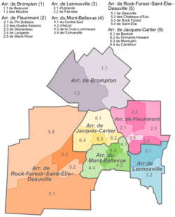
The borough comprises the formerly independent cities of
248:
The borough is represented by four councillors on the
302:
The borough also includes the smaller communities of
186:
174:
157:
149:
141:
136:
128:
123:
109:
104:
96:
84:
72:
62:
52:
21:
392:
8:
372:Borough of Rock Forest–Saint-Élie–Deauville
269:(2006 population 20,693) is located on the
191:Borough of Rock Forest–Saint-Élie–Deauville
399:
385:
377:
18:
357:Portrait de la ville, Ville de Sherbrooke
319:
185:
173:
156:
135:
122:
103:
51:
42:
34:
293:-like residence of one Parker Nagle.
148:
140:
127:
108:
95:
83:
71:
61:
7:
244:Sherbrooke municipal election, 2009
14:
448:Rock Forest–Saint-Élie–Deauville
332:Rock Forest—Saint-Élie—Deauville
199:Rock Forest–Saint-Élie–Deauville
132:156 km (60 sq mi)
44:
23:Rock Forest–Saint-Élie–Deauville
1:
110: • City councillors
153:227.56/km (589.4/sq mi)
517:
241:
418:
43:
35:
28:
16:Borough in Quebec, Canada
477:45.371417°N 71.988194°W
250:Sherbrooke City Council
501:Boroughs of Sherbrooke
408:Boroughs of Sherbrooke
482:45.371417; -71.988194
242:Further information:
150: • Density
473: /
338:on 16 December 2012
297:Saint-Élie-d'Orford
232:Saint-Élie-d'Orford
142: • Total
456:
455:
211:, of the city of
196:
195:
129: • Land
508:
488:
487:
485:
484:
483:
478:
474:
471:
470:
469:
466:
401:
394:
387:
378:
359:
354:
348:
347:
345:
343:
324:
48:
19:
516:
515:
511:
510:
509:
507:
506:
505:
491:
490:
481:
479:
475:
472:
467:
464:
462:
460:
459:
457:
452:
433:Jacques-Cartier
414:
405:
368:
363:
362:
355:
351:
341:
339:
326:
325:
321:
316:
258:
246:
240:
118:
117:Julien Lachance
116:
114:
100:January 1, 2002
31:
24:
17:
12:
11:
5:
514:
512:
504:
503:
493:
492:
454:
453:
451:
450:
445:
440:
435:
430:
425:
419:
416:
415:
406:
404:
403:
396:
389:
381:
375:
374:
367:
366:External links
364:
361:
360:
349:
318:
317:
315:
312:
257:
254:
239:
236:
204:arrondissement
194:
193:
188:
184:
183:
178:
172:
171:
161:
155:
154:
151:
147:
146:
143:
139:
138:
134:
133:
130:
126:
125:
121:
120:
111:
107:
106:
102:
101:
98:
94:
93:
88:
82:
81:
76:
70:
69:
64:
60:
59:
54:
50:
49:
41:
40:
33:
32:
29:
26:
25:
22:
15:
13:
10:
9:
6:
4:
3:
2:
513:
502:
499:
498:
496:
489:
486:
449:
446:
444:
443:Mont-Bellevue
441:
439:
436:
434:
431:
429:
426:
424:
421:
420:
417:
413:
409:
402:
397:
395:
390:
388:
383:
382:
379:
373:
370:
369:
365:
358:
353:
350:
337:
333:
329:
323:
320:
313:
311:
309:
305:
300:
298:
294:
292:
287:
284:
280:
276:
272:
268:
264:
262:
255:
253:
251:
245:
237:
235:
233:
229:
225:
220:
218:
214:
210:
206:
205:
200:
192:
189:
182:
179:
177:
169:
165:
162:
160:
152:
144:
131:
115:Annie Godbout
113:Diane Délisle
112:
99:
92:
89:
87:
80:
77:
75:
68:
65:
58:
55:
47:
39:
27:
20:
468:71°59′17.5″W
465:45°22′17.1″N
458:
447:
352:
340:. Retrieved
336:the original
331:
322:
307:
303:
301:
296:
295:
266:
265:
260:
259:
247:
231:
227:
223:
221:
202:
198:
197:
119:Bruno Vachon
480: /
438:Lennoxville
271:Magog River
267:Rock Forest
256:Communities
224:Rock Forest
36:Borough of
428:Fleurimont
328:"Portrait"
314:References
308:Val-du-Lac
286:immigrants
238:Government
213:Sherbrooke
137:Population
105:Government
91:Sherbrooke
38:Sherbrooke
261:Deauville
228:Deauville
176:Area code
159:Time zone
495:Category
423:Brompton
342:12 March
279:Scottish
63:Province
275:English
209:borough
187:Website
53:Country
30:Borough
412:Quebec
304:Shanks
291:castle
217:Quebec
201:is an
145:35,500
97:Merged
79:Estrie
74:Region
67:Quebec
57:Canada
283:Irish
207:, or
164:UTC-5
344:2012
306:and
281:and
230:and
124:Area
181:819
168:EST
86:RCM
497::
410:,
330:.
310:.
277:,
252:.
226:,
219:.
215:,
400:e
393:t
386:v
346:.
170:)
166:(
Text is available under the Creative Commons Attribution-ShareAlike License. Additional terms may apply.