40:
53:
60:
641:
634:
627:
431:
In its upper course in
Minnesota, the river collects the East Branch Rock River, about 15 miles (24 km) long, which flows for its entire length in Pipestone County. In Iowa, it collects the
1278:
52:
1293:
1179:
1209:
1199:
1189:
1184:
964:
750:
1214:
1169:
1102:
1077:
1194:
1174:
716:
206:
1283:
1204:
1120:
842:
1115:
1009:
992:
959:
905:
729:
950:
1288:
151:
1273:
765:
454:
755:
932:
876:
871:
854:
613:
588:
570:
760:
676:
1232:
619:
1244:
1014:
1268:
1125:
805:
701:
496:
1236:
1228:
1145:
1072:
459:
369:
120:
686:
739:
724:
449:
39:
599:
594:
484:
1263:
1140:
1240:
866:
861:
849:
837:
829:
671:
377:
357:
116:
691:
348:. The river's name comes from a prominent rocky outcrop about 175 feet high (designated "The Rock" on
408:
373:
681:
553:
444:
400:
356:, about 3 miles (5 km) north of Luverne. The outcrop of quartzite is contained in Minnesota's
485:
U.S. Geological Survey
Geographic Names Information System: Rock River (Big Sioux River tributary)
1135:
1034:
404:
396:
385:
108:
1062:
910:
654:
609:
584:
566:
432:
420:
412:
381:
345:
304:
265:
112:
534:
976:
937:
896:
706:
1084:
1050:
1039:
943:
663:
353:
349:
321:
192:
1161:
1024:
389:
341:
337:
1257:
1000:
696:
333:
84:
528:
513:
U.S. Geological Survey. National
Hydrography Dataset high-resolution flowline data.
775:
388:. It flows into the Big Sioux River in Sioux County, 6 miles (10 km) north of
600:
U.S. Geological Survey
Geographic Names Information System: East Branch Rock River
17:
187:
923:
416:
221:
208:
166:
153:
650:
325:
317:
98:
514:
576:
558:
595:
U.S. Geological Survey
Geographic Names Information System: Rock River
329:
94:
623:
372:, approximately 13 miles (21 km) northeast of the town of
59:
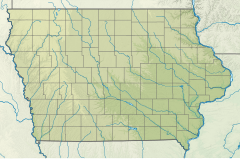
324:, about 144 miles (232 km) long, in southwestern
395:
Along its course the Rock River passes the towns of
1154:
1095:
1023:
975:
922:
895:
828:
804:
774:
738:
715:
662:
298:
290:
285:
271:
259:
251:
237:
198:
186:
143:
135:
126:
104:
90:
80:
75:
32:
608:. Minneapolis: University of Minnesota Press.
635:
8:
965:Little Cedar River (Dodge County, Minnesota)
642:
628:
620:
376:, and flows initially southwardly through
554:Columbia Gazetteer of North America entry
533:. Minnesota Historical Society. p.
960:Little Cedar River (Iowa and Minnesota)
472:
480:
478:
476:
352:1843 map of the area) of reddish-gray
29:
1279:Rivers of Pipestone County, Minnesota
792:South Branch Middle Fork Zumbro River
789:North Branch Middle Fork Zumbro River
7:
1294:Tributaries of the Mississippi River
455:List of longest streams of Minnesota
384:, where it turns southwestward into
606:The Streams and Rivers of Minnesota
25:
27:River in Minnesota, United States
1284:Rivers of Rock County, Minnesota
761:Little Cannon River (Sabre Lake)
58:
51:
38:
581:Minnesota Atlas & Gazetteer
411:in Minnesota; and the towns of
200: • coordinates
145: • coordinates
1:
1130:South Branch Vermillion River
915:North Branch Upper Iowa River
127:Physical characteristics
1289:Rivers of Sioux County, Iowa
1044:West Fork Little Sioux River
816:Middle Fork Whitewater River
813:North Fork Whitewater River
583:. Yarmouth, Maine: DeLorme.
565:. Yarmouth, Maine: DeLorme.
239: • elevation
1274:Rivers of Lyon County, Iowa
1229:List of rivers of Minnesota
980:(Iowa, Minnesota, Missouri)
821:South Fork Whitewater River
370:Pipestone County, Minnesota
261: • location
121:Pipestone County, Minnesota
1310:
986:East Fork Des Moines River
604:Waters, Thomas F. (1977).
563:Iowa Atlas & Gazetteer
530:Minnesota Geographic Names
340:rivers, it is part of the
273: • average
243:1,168 ft (356 m)
1225:
786:Middle Fork Zumbro River
653:tributaries of the Upper
517:, accessed March 30, 2011
368:The Rock River starts in
281:
247:
182:
131:
46:
37:
1110:South Fork Crooked Creek
1107:North Fork Crooked Creek
1096:Other rivers and streams
867:Middle Branch Root River
450:List of Minnesota rivers
336:. Via the Big Sioux and
862:North Branch Root River
850:South Branch Root River
797:South Fork Zumbro River
783:North Fork Zumbro River
462:(for other Rock Rivers)
300: • left
1067:East Branch Rock River
672:Little Minnesota River
657:below St Anthony Falls
527:Upham, Warren (1920).
378:Rock County, Minnesota
358:Blue Mounds State Park
117:Rock County, Minnesota
838:South Fork Root River
692:Yellow Medicine River
677:Pomme de Terre River
435:just south of Doon.
1269:Rivers of Minnesota
1245:North Dakota rivers
1233:North Shore Streams
751:Little Cannon River
682:Lac qui Parle River
445:List of Iowa rivers
286:Basin features
277:610 cu/ft. per sec.
222:43.0827°N 96.4545°W
218: /
167:44.1369°N 96.1231°W
163: /
1136:Wapsipinicon River
1035:Little Sioux River
989:Heron Lake Outlet
747:North Cannon River
386:Sioux County, Iowa
109:Sioux County, Iowa
1251:
1250:
1155:Streams by region
1063:Little Rock River
911:Little Iowa River
899:(Iowa, Minnesota)
655:Mississippi River
433:Little Rock River
382:Lyon County, Iowa
350:Joseph Nicollet's
346:Mississippi River
328:and northwestern
310:
309:
305:Champepadan Creek
266:Rock Valley, Iowa
227:43.0827; -96.4545
172:44.1369; -96.1231
113:Lyon County, Iowa
18:Rock River (Iowa)
16:(Redirected from
1301:
1237:Wisconsin rivers
1126:Vermillion River
1073:Split Rock Creek
1028:(Missouri, Iowa)
997:Diversion Creek
977:Des Moines River
938:Shell Rock River
897:Upper Iowa River
806:Whitewater River
707:Blue Earth River
702:Cottonwood River
644:
637:
630:
621:
546:
545:
543:
541:
524:
518:
515:The National Map
511:
505:
504:
493:
487:
482:
301:
274:
262:
233:
232:
230:
229:
228:
223:
219:
216:
215:
214:
211:
178:
177:
175:
174:
173:
168:
164:
161:
160:
159:
156:
146:
62:
61:
55:
42:
30:
21:
1309:
1308:
1304:
1303:
1302:
1300:
1299:
1298:
1254:
1253:
1252:
1247:
1221:
1150:
1146:Winnebago Creek
1091:
1085:Flandreau Creek
1078:Pipestone Creek
1051:Big Sioux River
1040:Ocheyedan River
1027:
1019:
979:
971:
944:Winnebago River
918:
891:
884:Hemingway Creek
881:Coolridge Creek
824:
800:
770:
734:
717:St. Croix River
711:
664:Minnesota River
658:
648:
550:
549:
539:
537:
526:
525:
521:
512:
508:
495:
494:
490:
483:
474:
469:
441:
429:
366:
354:Sioux Quartzite
322:Big Sioux River
299:
272:
260:
240:
226:
224:
220:
217:
212:
209:
207:
205:
204:
201:
193:Big Sioux River
171:
169:
165:
162:
157:
154:
152:
150:
149:
144:
71:
70:
69:
68:
65:
64:
63:
28:
23:
22:
15:
12:
11:
5:
1307:
1305:
1297:
1296:
1291:
1286:
1281:
1276:
1271:
1266:
1264:Rivers of Iowa
1256:
1255:
1249:
1248:
1226:
1223:
1222:
1220:
1219:
1218:
1217:
1212:
1207:
1202:
1197:
1192:
1187:
1182:
1177:
1172:
1164:
1162:Driftless Area
1158:
1156:
1152:
1151:
1149:
1148:
1143:
1138:
1133:
1132:
1131:
1123:
1118:
1113:
1112:
1111:
1108:
1099:
1097:
1093:
1092:
1090:
1089:
1088:
1087:
1082:
1081:
1080:
1070:
1069:
1068:
1065:
1047:
1046:
1045:
1042:
1031:
1029:
1025:Missouri River
1021:
1020:
1018:
1017:
1012:
1007:
1006:
1005:
1004:
1003:
995:
987:
983:
981:
973:
972:
970:
969:
968:
967:
962:
957:
956:
955:
954:
953:
929:
927:
920:
919:
917:
916:
913:
908:
902:
900:
893:
892:
890:
889:
888:
887:
886:
885:
882:
869:
864:
859:
858:
857:
847:
846:
845:
834:
832:
826:
825:
823:
822:
819:
818:
817:
810:
808:
802:
801:
799:
798:
795:
794:
793:
790:
784:
780:
778:
772:
771:
769:
768:
763:
758:
756:Straight River
753:
748:
744:
742:
736:
735:
733:
732:
727:
721:
719:
713:
712:
710:
709:
704:
699:
694:
689:
687:Chippewa River
684:
679:
674:
668:
666:
660:
659:
649:
647:
646:
639:
632:
624:
618:
617:
602:
597:
592:
574:
556:
548:
547:
519:
506:
488:
471:
470:
468:
465:
464:
463:
457:
452:
447:
440:
437:
428:
425:
365:
362:
308:
307:
302:
296:
295:
292:
288:
287:
283:
282:
279:
278:
275:
269:
268:
263:
257:
256:
253:
249:
248:
245:
244:
241:
238:
235:
234:
202:
199:
196:
195:
190:
184:
183:
180:
179:
147:
141:
140:
137:
133:
132:
129:
128:
124:
123:
106:
102:
101:
92:
88:
87:
82:
78:
77:
73:
72:
66:
57:
56:
50:
49:
48:
47:
44:
43:
35:
34:
26:
24:
14:
13:
10:
9:
6:
4:
3:
2:
1306:
1295:
1292:
1290:
1287:
1285:
1282:
1280:
1277:
1275:
1272:
1270:
1267:
1265:
1262:
1261:
1259:
1246:
1242:
1238:
1234:
1230:
1224:
1216:
1213:
1211:
1208:
1206:
1203:
1201:
1198:
1196:
1193:
1191:
1188:
1186:
1183:
1181:
1178:
1176:
1173:
1171:
1168:
1167:
1165:
1163:
1160:
1159:
1157:
1153:
1147:
1144:
1142:
1139:
1137:
1134:
1129:
1128:
1127:
1124:
1122:
1119:
1117:
1114:
1109:
1106:
1105:
1104:
1103:Crooked Creek
1101:
1100:
1098:
1094:
1086:
1083:
1079:
1076:
1075:
1074:
1071:
1066:
1064:
1061:
1060:
1059:
1056:
1055:
1054:
1052:
1048:
1043:
1041:
1038:
1037:
1036:
1033:
1032:
1030:
1026:
1022:
1016:
1013:
1011:
1008:
1002:
1001:Okabena Creek
999:
998:
996:
994:
991:
990:
988:
985:
984:
982:
978:
974:
966:
963:
961:
958:
952:
949:
948:
947:
945:
941:
940:
939:
936:
935:
934:
931:
930:
928:
925:
921:
914:
912:
909:
907:
904:
903:
901:
898:
894:
883:
880:
879:
878:
875:
874:
873:
870:
868:
865:
863:
860:
856:
853:
852:
851:
848:
844:
841:
840:
839:
836:
835:
833:
831:
827:
820:
815:
814:
812:
811:
809:
807:
803:
796:
791:
788:
787:
785:
782:
781:
779:
777:
773:
767:
764:
762:
759:
757:
754:
752:
749:
746:
745:
743:
741:
737:
731:
728:
726:
723:
722:
720:
718:
714:
708:
705:
703:
700:
698:
697:Redwood River
695:
693:
690:
688:
685:
683:
680:
678:
675:
673:
670:
669:
667:
665:
661:
656:
652:
645:
640:
638:
633:
631:
626:
625:
622:
615:
614:0-8166-0960-8
611:
607:
603:
601:
598:
596:
593:
590:
589:0-89933-222-6
586:
582:
578:
575:
572:
571:0-89933-214-5
568:
564:
560:
557:
555:
552:
551:
536:
532:
531:
523:
520:
516:
510:
507:
502:
498:
492:
489:
486:
481:
479:
477:
473:
466:
461:
458:
456:
453:
451:
448:
446:
443:
442:
438:
436:
434:
426:
424:
422:
418:
414:
410:
406:
402:
398:
393:
391:
387:
383:
379:
375:
371:
363:
361:
359:
355:
351:
347:
343:
339:
335:
334:United States
331:
327:
323:
319:
315:
306:
303:
297:
293:
289:
284:
280:
276:
270:
267:
264:
258:
254:
250:
246:
242:
236:
231:
203:
197:
194:
191:
189:
185:
181:
176:
148:
142:
138:
134:
130:
125:
122:
118:
114:
110:
107:
103:
100:
96:
93:
89:
86:
85:United States
83:
79:
74:
54:
45:
41:
36:
31:
19:
1057:
1049:
1015:Beaver Creek
942:
843:Badger Creek
776:Zumbro River
740:Cannon River
725:Kettle River
605:
580:
562:
538:. Retrieved
529:
522:
509:
500:
497:"Water Data"
491:
430:
394:
367:
313:
311:
1241:Iowa rivers
1227:See also:
1141:Wells Creek
933:Cedar River
766:Belle Creek
730:Snake River
540:30 November
427:Tributaries
421:Rock Valley
413:Rock Rapids
291:Tributaries
225: /
170: /
1258:Categories
1121:Pine Creek
1058:Rock River
1010:Lime Creek
993:Jack Creek
951:Lime Creek
924:Iowa River
906:Pine Creek
877:Pine Creek
872:Rush Creek
855:Camp Creek
830:Root River
467:References
460:Rock River
314:Rock River
213:96°27′16″W
210:43°04′58″N
158:96°07′23″W
155:44°08′13″N
33:Rock River
1166:Counties
1116:Hay Creek
651:Minnesota
423:in Iowa.
409:Ash Creek
374:Pipestone
342:watershed
326:Minnesota
318:tributary
252:Discharge
99:Minnesota
1180:Fillmore
579:(1994).
561:(1998).
439:See also
401:Edgerton
390:Hawarden
338:Missouri
105:District
76:Location
1210:Wabasha
1200:Olmsted
1190:Houston
1185:Goodhue
577:DeLorme
559:DeLorme
405:Luverne
397:Holland
344:of the
332:in the
320:of the
81:Country
1215:Winona
1170:Dakota
1053:(Iowa)
946:(Iowa)
926:(Iowa)
612:
587:
569:
380:, and
364:Course
294:
255:
139:
136:Source
1195:Mower
1175:Dodge
316:is a
188:Mouth
91:State
67:Mouth
1205:Rice
610:ISBN
585:ISBN
567:ISBN
542:2019
501:USGS
419:and
417:Doon
407:and
330:Iowa
312:The
95:Iowa
535:466
1260::
1243:,
1239:,
1235:,
1231:,
499:.
475:^
415:,
403:,
399:,
392:.
360:.
119:,
115:,
111:,
97:,
643:e
636:t
629:v
616:.
591:.
573:.
544:.
503:.
20:)
Text is available under the Creative Commons Attribution-ShareAlike License. Additional terms may apply.