102:(SSSI). The northern area is the largest, and consists of a large area of forest clearings in the Near Hill Clough Wood and the Far Hill Clough Wood immediately to the south of Charnock. The site is located mainly on the southern bank of the Robin Brook, with the clearings in the trees supporting a meadow habitat. The southern area is located further south, close to Hazlehurst Farm, in forest clearings in Parson's Wood and the neighborouring Joshua Holt woodland on the southern bank of the Robin Brook. The SSSI includes a third area, which is located in an area of open land just outside Geerlane, on the southern bank of the Moss just upstream from where the Robin Brook joins it. The three areas are all north-facing, with neutral to acidic soils, and are populated by a rich variety of grassland animals and plants. They are one of the best preserved areas of semi-natural woodland in north east Derbyshire, and include several species which are either local or rare. They have been designated as an SSSI since 1990.
71:
505:
546:
216:
167:
489:
575:
539:
420:
209:
99:
70:
532:
482:
202:
275:
570:
565:
475:
386:
321:
181:
129:
391:
504:
336:
238:
366:
361:
83:
The stream originates in
Charnock, flowing south, almost parallel to White Lane. It then enters
516:
459:
265:
48:
512:
396:
376:
331:
311:
28:
559:
356:
316:
270:
87:
at
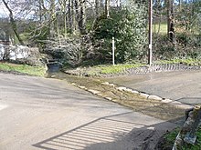
Ridgeway, heading south down Ridgeway Moor, crossing Sloade Lane in the hamlet of
406:
401:
326:
306:
260:
255:
145:
381:
346:
280:
351:
341:
84:
40:
435:
422:
98:
Two areas along the course of the stream are part of the Moss Valley
Meadows
24:
301:
285:
92:
88:
44:
32:
194:
36:
69:
39:
area of the city, where it flows south, crossing the border into
198:
91:. The stream then passes under the road at Ford before meeting
23:
is a small stream originating in the south eastern part of the
520:
463:
294:
248:
230:
458:This article related to a river in England is a
540:
483:
210:
146:"Conserving the Moss Valley and its Wildlife"
8:
547:
533:
490:
476:
217:
203:
195:
168:"Magic map of Moss Valley Meadows SSSI"
111:
59:The stream was referred to in 1570 as
35:. The source of the stream is in the
7:
501:
499:
455:
453:
100:Site of Special Scientific Interest
519:. You can help Knowledge (XXG) by
462:. You can help Knowledge (XXG) by
16:Stream in South Yorkshire, England
14:
74:Robin Brook crossing Sloade Lane.
503:
295:Minor rivers, streams and brooks
576:South Yorkshire geography stubs
1:
131:The Place-names of Derbyshire
148:. Moss Valley Wildlife Group
118:Ordnance Survey, 1:2500 map
592:
498:
452:
266:River Porter or Little Don
182:"Moss Valley Meadows SSSI"
128:Cameron, Kenneth (1959).
134:. The University Press.
515:location article is a
75:
73:
571:England river stubs
566:Rivers of Sheffield
432: /
377:Sheffield Lane Dike
225:Rivers in Sheffield
436:53.3396°N 1.4132°W
332:Hartley Brook Dike
187:. Natural England.
76:
528:
527:
471:
470:
415:
414:
25:City of Sheffield
583:
549:
542:
535:
507:
500:
492:
485:
478:
454:
447:
446:
444:
443:
442:
441:53.3396; -1.4132
437:
433:
430:
429:
428:
425:
387:Shirtcliff Brook
337:Kirk Bridge Dike
219:
212:
205:
196:
189:
188:
186:
178:
172:
171:
164:
158:
157:
155:
153:
142:
136:
135:
125:
119:
116:
591:
590:
586:
585:
584:
582:
581:
580:
556:
555:
554:
553:
513:South Yorkshire
497:
496:
450:
440:
438:
434:
431:
426:
423:
421:
419:
418:
416:
411:
312:Blackburn Brook
290:
244:
226:
223:
193:
192:
184:
180:
179:
175:
166:
165:
161:
151:
149:
144:
143:
139:
127:
126:
122:
117:
113:
108:
81:
63:and in 1754 as
57:
29:South Yorkshire
17:
12:
11:
5:
589:
587:
579:
578:
573:
568:
558:
557:
552:
551:
544:
537:
529:
526:
525:
508:
495:
494:
487:
480:
472:
469:
468:
413:
412:
410:
409:
404:
399:
394:
389:
384:
379:
374:
369:
364:
359:
354:
349:
344:
339:
334:
329:
324:
319:
314:
309:
304:
298:
296:
292:
291:
289:
288:
283:
278:
273:
268:
263:
258:
252:
250:
246:
245:
243:
242:
234:
232:
228:
227:
224:
222:
221:
214:
207:
199:
191:
190:
173:
159:
137:
120:
110:
109:
107:
104:
80:
77:
56:
53:
15:
13:
10:
9:
6:
4:
3:
2:
588:
577:
574:
572:
569:
567:
564:
563:
561:
550:
545:
543:
538:
536:
531:
530:
524:
522:
518:
514:
509:
506:
502:
493:
488:
486:
481:
479:
474:
473:
467:
465:
461:
456:
451:
448:
445:
408:
405:
403:
400:
398:
397:Tongue Gutter
395:
393:
390:
388:
385:
383:
380:
378:
375:
373:
370:
368:
365:
363:
360:
358:
357:Old Hay Brook
355:
353:
350:
348:
345:
343:
340:
338:
335:
333:
330:
328:
325:
323:
320:
318:
317:Burbage Brook
315:
313:
310:
308:
305:
303:
300:
299:
297:
293:
287:
284:
282:
279:
277:
274:
272:
271:River Rivelin
269:
267:
264:
262:
259:
257:
254:
253:
251:
247:
241:
240:
236:
235:
233:
229:
220:
215:
213:
208:
206:
201:
200:
197:
183:
177:
174:
169:
163:
160:
147:
141:
138:
133:
132:
124:
121:
115:
112:
105:
103:
101:
96:
94:
90:
86:
78:
72:
68:
66:
65:Robbing Brook
62:
61:Robbyn brooke
54:
52:
50:
46:
42:
38:
34:
30:
26:
22:
521:expanding it
510:
464:expanding it
457:
449:
417:
407:Wyming Brook
402:Totley Brook
392:Storrs Brook
371:
367:Raeburn Rill
276:River Rother
261:River Loxley
256:Porter Brook
249:Other rivers
237:
176:
162:
150:. Retrieved
140:
130:
123:
114:
97:
82:
64:
60:
58:
20:
18:
439: /
382:Shire Brook
372:Robin Brook
362:Owler Brook
347:Meers Brook
307:Bagley Dike
281:River Sheaf
43:. It meets
21:Robin Brook
560:Categories
424:53°20′23″N
352:Ochre Dyke
342:Limb Brook
327:Ewden Beck
322:Carr Brook
302:Allen Sike
231:Main river
106:References
85:Derbyshire
41:Derbyshire
427:1°24′48″W
239:River Don
286:The Moss
170:. Defra.
152:24 March
93:The Moss
89:Geerlane
45:The Moss
37:Charnock
55:History
33:England
79:Course
511:This
185:(PDF)
517:stub
460:stub
154:2021
49:Ford
19:The
47:at
27:in
562::
95:.
67:.
51:.
31:,
548:e
541:t
534:v
523:.
491:e
484:t
477:v
466:.
218:e
211:t
204:v
156:.
Text is available under the Creative Commons Attribution-ShareAlike License. Additional terms may apply.