246:
via San Diego Bay step overs, however no clear connection has been determined. Around the San Diego Bay, the fault splays out into many different strands, such as the Silver Strand and
Spanish Bight faults. Some of these splay faults come very close to the Descanso Fault, which in turn links with the Agua Blanca Fault. This leads certain researchers to consider these faults interconnected as one major fault zone, the Newport Inglewood–Rose Canyon–Descanso–Agua Blanca Fault Zone. Others favor an interpretation which links the Rose Canyon to the San Miguel-Vallecitos Fault Zone, though just like with the Descanso and Agua Blanca faults, there are no visible faults connecting the two. Other researchers attempting to determine which of the two faults the Rose Canyon connects to in the south provide evidence for both faults having a potential link.
174:. Conservative estimates of the fault place the length around 30–50 km (19–31 mi), while interpretations including the NIFZ place the length at 170 km (110 mi). There are not many earthquakes associated with the fault, however a magnitude 6–6.5 may have struck on the fault in 1862. The fault runs very near to populated areas when offshore, hence there is high potential for infrequent large and damaging earthquakes.
36:
131:
209:(CCB). The San Andreas system and the ECSZ take up around 85% of the deformation, while the CCB accommodates the rest. The CCB is itself split into the Inner (ICB) and Outer Continental Borderlands. The ICB takes up ~6–8 mm (0.24–0.31 in) of the plate boundary's slip, with the Rose Canyon Fault being one of the most hazardous faults in the ICB system.
245:
The southern terminus of the Rose Canyon Fault Zone has not been conclusively determined, and is considered to connect to the
Descanso and Agua Blanca Faults and/or the San Miguel–Vallecitos Fault Zone. Researchers have suggested that both of these faults may transfer slip to the Rose Canyon Fault
29:
Rose Canyon Fault Zone, Newport
Inglewood-Rose Canyon Fault Zone, Newport Inglewood-Rose Canyon-Vallecitos-San Miguel Fault Zone, Newport Inglewood-Rose Canyon-Descanso-Agua Blanca Fault Zone
266:(over 100 mi (160 km) away). However, due to the lack of reports in the area, it is not possible to guarantee that this earthquake occurred on the Rose Canyon Fault.
768:
Investigating recent deformation along the southern San Pedro Basin fault to assess evidence for connectivity between the San Pedro Basin and San Diego Trough fault systems
348:
The
Southern California Earthquake Center has the fault at 30km, A 2010 paper by Thomas Rockwell has it at 40km, and a 1997 book by Glenn Roquemore has the length at 50km.
2093:
1602:
712:
Abbott, Patrick L.; Elliott, William J. (November 1979). "Faulting offshore San Diego and northern Baja
California". In Legg, Mark R.; Kennedy, Michael P. (eds.).
286:. On the fault, earthquakes nearing magnitude 7 have a recurrence interval between 700±400 and 2,000 years. Scenarios modeling a magnitude 6.9 earthquake predict
254:
The Rose Canyon Fault has little associated historic seismicity, however a magnitude 6–6.5 earthquake in 1862 is often attributed to it. The shock was assigned a
735:
1038:"Seismic constraints on the architecture of the Newport-Inglewood/Rose Canyon fault: Implications for the length and magnitude of future earthquake ruptures"
1153:
1910:
1516:
2034:
1668:
830:
270:
of the fault reveals multiple ruptures within the past 8,100 years, including a rupture that occurred between 300 years to shortly before the
2088:
1554:
1026:
1378:
1071:
915:"Inception of the eastern California shear zone and evolution of the Pacific-North American plate boundary: From kinematics to geodynamics"
282:
The Rose Canyon Fault Zone can produce large earthquakes which can be very destructive due to its proximity to major population centers in
1595:
221:
fault extends for 30–50 km (19–31 mi) and slips at a rate of 1.1–2 mm (0.043–0.079 in)/yr. The fault begins in the
2103:
1994:
332:. Other studies link the Rose Canyon Fault with the Newport-Inglewood, and the combined fault zone can produce M7.3–7.4 earthquakes.
1692:
255:
1869:
1569:
1531:
1126:
411:
2045:
1146:
1984:
1979:
1588:
1778:
1720:
1656:
1260:
202:
954:
2098:
2040:
1559:
862:
810:
1833:
1255:
206:
159:
86:
1750:
1644:
1564:
1295:
997:
167:
1036:
Sahakian, Valerie; Bormann, Jayne; Driscoll, Neal; Harding, Alistair; Kent, Graham; Wesnousky, Steve (7 March 2017).
1956:
1740:
1506:
1139:
1131:
1900:
1413:
1408:
1650:
1638:
1491:
287:
1018:
The
Seismic Risk in the San Diego Region: Special Focus on the Rose Canyon Fault Systems: Workshop Proceedings
977:
767:
1946:
1828:
1715:
1521:
1486:
1403:
1368:
1330:
1315:
309:
230:
1848:
1310:
1974:
328:
may experience localized coastal bluff failures, and submarine canyons may have landslides which trigger
2050:
2029:
2004:
1730:
1511:
1496:
1300:
1037:
291:
234:
218:
171:
1002:. International Conferences on Recent Advances in Geotechnical Earthquake Engineering and Soil Dynamics
787:
163:
1423:
1988:
1433:
1210:
926:
194:
1925:
882:
1951:
1852:
1773:
1580:
1526:
1360:
1250:
1245:
1220:
1202:
1122:
283:
182:
106:
1072:
Paleoseismic
Assessment of the Late Holocene Rupture History of the Rose Canyon Fault in San Diego
35:
2067:
2062:
1838:
1823:
1783:
1745:
1674:
1458:
1438:
1388:
1290:
1270:
1225:
305:
186:
1078:
229:
before turning offshore. It extends north paralleling the coastline before connecting with the
1725:
1686:
1501:
1418:
1350:
1305:
1265:
1187:
1022:
271:
198:
1536:
1428:
1393:
1340:
1320:
1049:
1016:
934:
894:
842:
747:
147:
1813:
1735:
1680:
1632:
1615:
1468:
1448:
1443:
1373:
1325:
1235:
1165:
267:
143:
122:
116:
1106:
930:
1941:
1905:
1345:
1192:
274:
was established. Some of these historic ruptures have an estimated magnitude of 7–7.3.
978:
Mid to Late
Holocene Rupture History of the Rose Canyon Fault in San Diego, California
2082:
2056:
2024:
1884:
1818:
1787:
1698:
1478:
1398:
1383:
1335:
1285:
1275:
1230:
419:
222:
190:
863:"San Diego faces critical earthquake danger from fault long believed to be inactive"
1999:
1920:
1791:
1662:
1240:
313:
713:
1915:
1879:
1797:
1541:
1463:
1453:
1215:
317:
263:
130:
1874:
1612:
1173:
1162:
736:"Past and Possible Future Earthquakes of Significance to the San Diego Region"
325:
321:
151:
831:"A Northward-propagating Earthquake Sequence in Coastal Southern California?"
1169:
477:
475:
473:
155:
846:
883:"Holocene activity of the Rose Canyon fault zone in San Diego, California"
1054:
938:
226:
531:
529:
953:
Maloney, Jillian M.; Legg, Mark; Nicholson, Craig; Rockwell, Thomas K.
914:
734:
Anderson, John G.; Rockwell, Thomas K.; Agnew, Duncan Carr (May 1989).
329:
301:
898:
751:
237:, and the two faults together extend for 170 km (110 mi).
129:
1584:
1135:
1077:(Report). San Onofre Nuclear Generating Station. Archived from
40:
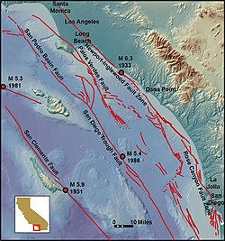
The Rose Canyon Fault is located at the bottom right of the map
481:
881:
Lindvall, Scott C.; Rockwell, Thomas K. (10 December 1995).
146:
fault that runs in a north–south direction off the coast of
197:. Faulting is taken up by three main groups of faults: the
535:
395:
666:
664:
418:. Southern California Earthquake Center. Archived from
1108:
Geology of the San Diego metropolitan area, California
367:
365:
607:
504:
502:
976:
Rockwell, Thomas K.; Singleton, Drake (April 2018).
955:"White Paper: The California continental borderland"
2017:
1965:
1934:
1893:
1862:
1806:
1766:
1759:
1708:
1623:
1477:
1359:
1201:
1180:
115:
105:
100:
92:
82:
77:
69:
61:
53:
45:
23:
913:Liu, Mian; Wang, Hui; Li, Qingsong (7 July 2010).
571:
547:
493:
655:
559:
464:
721:. San Diego Association of Geologists Guidebook
1596:
1147:
715:Earthquakes and other perils—San Diego region
595:
583:
520:
8:
1042:Journal of Geophysical Research: Solid Earth
887:Journal of Geophysical Research: Solid Earth
829:Grant, Lisa B.; Rockwell, Thomas K. (2002).
1111:. California Division of Mines and Geology.
1763:
1603:
1589:
1581:
1517:Rescue Lineament-Bear Mountains fault zone
1154:
1140:
1132:
1123:Faults and Earthquakes in San Diego County
34:
1053:
643:
619:
452:
383:
1985:Middleton Place–Summerville Seismic Zone
440:
2094:Geology of San Diego County, California
999:The Rose Canyon Fault Zone in San Diego
670:
631:
371:
361:
341:
1911:Long Point–Eureka Heights fault system
1669:Northern Cordilleran Volcanic Province
811:San Diego Earthquake Planning Scenario
682:
406:
404:
262:). Shaking was widespread and felt in
20:
2035:Enriquillo–Plantain Garden fault zone
962:Southern California Earthquake Center
508:
416:Southern California Earthquake Center
324:. Coastal areas such as La Jolla and
7:
1379:Clayton-Marsh Creek-Greenville Fault
694:
154:until it comes ashore near downtown
16:Seismic fault in Southern California
996:Rockwell, Thomas K. (28 May 2010).
788:"Earthquake San Diego Danger Zones"
608:Anderson, Rockwell & Agnew 1989
162:(NIFZ) in the north and either the
1995:Northern Appalachians Seismic Zone
861:Lin II, Rong-Gong (4 March 2020).
786:De Wyze, Jeannete (2 March 2000).
14:
1693:Southern Great Lakes Seismic Zone
1015:Roquemore, Glenn (1 April 1997).
207:California Continental Borderland
87:California Continental Borderland
1870:Independence Valley fault system
1532:Sierra Nevada-Great Valley Block
1127:San Diego Natural History Museum
773:(Report). U.S. Geological Survey
168:San Miguel–Vallecitos Fault Zone
96:~30–170 km (19–106 mi)
2046:Lesser Antilles subduction zone
919:Journal of Geophysical Research
1980:Eastern Tennessee Seismic Zone
835:Seismological Research Letters
766:Bormann, Jayne; Kent, Graham.
57:Onshore and offshore San Diego
1:
1721:Laurentian Slope Seismic Zone
1657:Clarendon-Linden fault system
1261:Northridge Blind Thrust Fault
572:Rockwell & Singleton 2018
548:Rockwell & Singleton 2018
494:Rockwell & Singleton 2018
203:Eastern California Shear Zone
158:. The fault is linked to the
2089:Seismic faults of California
2041:Gulf of California Rift Zone
1560:California Geological Survey
1105:Kennedy, Michael P. (1975).
656:Lindvall & Rockwell 1995
560:Lindvall & Rockwell 1995
465:Lindvall & Rockwell 1995
296:in San Diego, and 0.35
170:in the south via en echelon
1901:Central Oklahoma Fault Zone
1751:Western Quebec Seismic Zone
1645:Canadian Arctic Rift System
1565:Seismic Hazards Mapping Act
1296:San Diego Trough Fault Zone
256:Modified Mercalli intensity
2120:
1957:Wabash Valley Seismic Zone
1741:Saint Lawrence rift system
1626:(crosses national borders)
1507:Maria fold and thrust belt
2104:Mission Valley, San Diego
1779:Olympic–Wallowa Lineament
1550:
1414:Mount Diablo Thrust Fault
1409:Mendocino Triple Junction
596:Abbott & Elliott 1979
584:Grant & Rockwell 2002
521:Abbott & Elliott 1979
111:1862 San Diego earthquake
33:
28:
1651:Cascadia subduction zone
1639:Basin and Range Province
1492:Furnace Creek Fault Zone
412:"Rose Canyon Fault Zone"
288:peak ground acceleration
1947:New Madrid Seismic Zone
1834:Newport–Inglewood Fault
1829:Mendocino Fracture Zone
1716:Charlevoix Seismic Zone
1522:Sierra Nevada Batholith
1487:Death Valley Fault Zone
1404:Mendocino Fracture Zone
1331:Sierra Madre Fault Zone
1316:Santa Maria River Fault
1256:Newport–Inglewood Fault
1070:SONGS (December 2012).
384:Liu, Wang & Li 2010
231:Newport-Inglewood Fault
201:and linked faults, the
160:Newport–Inglewood Fault
1849:San Jacinto Fault Zone
1369:Bartlett Springs Fault
1311:San Jacinto Fault Zone
847:10.1785/GSSRL.73.4.461
135:
2051:Middle America Trench
2030:Chixoy-Polochic Fault
2005:Virginia Seismic Zone
1966:Appalachian Mountains
1767:Washington and Oregon
1731:Queen Charlotte Fault
1497:Honey Lake Fault Zone
1301:San Felipe Fault Zone
290:will reach 0.55
233:via short en echelon
213:Fault characteristics
134:Rose Canyon Fault Map
133:
2018:Caribbean and Mexico
1211:Brawley Seismic Zone
1084:on 15 September 2017
1055:10.1002/2016JB013467
1021:. DIANE Publishing.
939:10.1029/2009JB007055
893:(B12): 24121–24132.
482:Sahakian et al. 2017
225:, then runs through
195:North American Plate
2099:La Jolla, San Diego
1975:Aiken–Augusta Fault
1952:Sandwich Fault Zone
1853:Elsinore Fault Zone
1774:Brothers Fault Zone
1527:Sierra Nevada Fault
1361:Northern California
1251:Laguna Salada Fault
1246:Imperial Fault Zone
1221:Elsinore Fault Zone
1203:Southern California
931:2010JGRB..115.7401L
284:Southern California
183:Southern California
142:is a right-lateral
2068:Puerto Rico Trench
2063:Pedro Miguel Fault
1968:and Atlantic Coast
1839:Puente Hills Fault
1824:Hayward Fault Zone
1746:Timiskaming Graben
1675:Puget Sound faults
1613:seismically active
1512:Owens Valley Fault
1459:Silver Creek Fault
1439:San Gregorio Fault
1389:Hayward Fault Zone
1291:San Cayetano Fault
1271:Puente Hills Fault
1226:Elysian Park Fault
1163:Seismically active
740:Earthquake Spectra
372:Bormann & Kent
306:Downtown San Diego
217:The right-lateral
187:transform boundary
136:
2076:
2075:
2059:(Central America)
2053:(Central America)
2013:
2012:
1921:Nemaha Fault Zone
1844:Rose Canyon Fault
1726:Leech River Fault
1687:San Andreas Fault
1578:
1577:
1502:Kern Canyon Fault
1419:Monta Vista Fault
1351:Yorba Linda Fault
1306:San Gabriel Fault
1281:Rose Canyon Fault
1266:Peninsular Ranges
1188:San Andreas Fault
1028:978-0-7881-4262-8
899:10.1029/95JB02627
752:10.1193/1.1585524
272:San Diego Mission
241:Southern terminus
199:San Andreas Fault
164:Agua Blanca Fault
140:Rose Canyon Fault
128:
127:
24:Rose Canyon Fault
2111:
1764:
1618:of North America
1605:
1598:
1591:
1582:
1537:Smartville Block
1429:Pleasanton Fault
1424:Nacimiento Fault
1394:Healdsburg Fault
1341:White Wolf Fault
1321:Santa Ynez Fault
1181:Statewide Faults
1156:
1149:
1142:
1133:
1112:
1093:
1091:
1089:
1083:
1076:
1066:
1064:
1062:
1057:
1032:
1011:
1009:
1007:
992:
990:
988:
982:
972:
970:
968:
959:
949:
947:
945:
909:
907:
905:
877:
875:
873:
857:
855:
853:
825:
823:
821:
815:
805:
803:
801:
795:San Diego Reader
792:
782:
780:
778:
772:
762:
760:
758:
730:
728:
726:
720:
698:
692:
686:
680:
674:
668:
659:
653:
647:
641:
635:
629:
623:
617:
611:
605:
599:
593:
587:
581:
575:
569:
563:
557:
551:
545:
539:
533:
524:
518:
512:
506:
497:
491:
485:
479:
468:
462:
456:
450:
444:
438:
432:
431:
429:
427:
408:
399:
393:
387:
381:
375:
369:
349:
346:
312:will experience
258:shaking of VII (
250:Seismic activity
205:(ECSZ), and the
178:Tectonic setting
148:San Diego County
38:
21:
2119:
2118:
2114:
2113:
2112:
2110:
2109:
2108:
2079:
2078:
2077:
2072:
2009:
1989:Woodstock Fault
1967:
1961:
1930:
1889:
1858:
1814:Calaveras Fault
1802:
1755:
1736:Saguenay Graben
1704:
1681:Rio Grande rift
1633:Aleutian Trench
1625:
1619:
1609:
1579:
1574:
1546:
1473:
1469:West Napa Fault
1449:Seal Cove Fault
1444:San Pablo Fault
1434:Rinconada Fault
1374:Calaveras Fault
1355:
1326:Shoreline Fault
1236:Hollywood fault
1197:
1176:
1170:tectonic blocks
1160:
1119:
1104:
1101:
1099:Further reading
1096:
1087:
1085:
1081:
1074:
1069:
1060:
1058:
1035:
1029:
1014:
1005:
1003:
995:
986:
984:
980:
975:
966:
964:
957:
952:
943:
941:
912:
903:
901:
880:
871:
869:
860:
851:
849:
828:
819:
817:
813:
808:
799:
797:
790:
785:
776:
774:
770:
765:
756:
754:
733:
724:
722:
718:
711:
702:
701:
693:
689:
681:
677:
669:
662:
654:
650:
642:
638:
630:
626:
618:
614:
606:
602:
594:
590:
582:
578:
570:
566:
558:
554:
546:
542:
534:
527:
519:
515:
507:
500:
492:
488:
480:
471:
463:
459:
451:
447:
439:
435:
425:
423:
422:on 16 July 2011
410:
409:
402:
394:
390:
382:
378:
370:
363:
358:
353:
352:
347:
343:
338:
320:may experience
280:
252:
243:
215:
180:
78:Characteristics
41:
17:
12:
11:
5:
2117:
2115:
2107:
2106:
2101:
2096:
2091:
2081:
2080:
2074:
2073:
2071:
2070:
2065:
2060:
2054:
2048:
2043:
2038:
2032:
2027:
2021:
2019:
2015:
2014:
2011:
2010:
2008:
2007:
2002:
1997:
1992:
1982:
1977:
1971:
1969:
1963:
1962:
1960:
1959:
1954:
1949:
1944:
1942:Marianna Fault
1938:
1936:
1932:
1931:
1929:
1928:
1926:Wilzetta Fault
1923:
1918:
1913:
1908:
1906:Humboldt Fault
1903:
1897:
1895:
1891:
1890:
1888:
1887:
1882:
1877:
1872:
1866:
1864:
1860:
1859:
1857:
1856:
1846:
1841:
1836:
1831:
1826:
1821:
1816:
1810:
1808:
1804:
1803:
1801:
1800:
1795:
1781:
1776:
1770:
1768:
1761:
1757:
1756:
1754:
1753:
1748:
1743:
1738:
1733:
1728:
1723:
1718:
1712:
1710:
1706:
1705:
1703:
1702:
1696:
1690:
1684:
1678:
1672:
1666:
1660:
1654:
1648:
1642:
1636:
1629:
1627:
1621:
1620:
1610:
1608:
1607:
1600:
1593:
1585:
1576:
1575:
1573:
1572:
1567:
1562:
1557:
1551:
1548:
1547:
1545:
1544:
1539:
1534:
1529:
1524:
1519:
1514:
1509:
1504:
1499:
1494:
1489:
1483:
1481:
1475:
1474:
1472:
1471:
1466:
1461:
1456:
1451:
1446:
1441:
1436:
1431:
1426:
1421:
1416:
1411:
1406:
1401:
1396:
1391:
1386:
1381:
1376:
1371:
1365:
1363:
1357:
1356:
1354:
1353:
1348:
1346:Whittier Fault
1343:
1338:
1333:
1328:
1323:
1318:
1313:
1308:
1303:
1298:
1293:
1288:
1283:
1278:
1273:
1268:
1263:
1258:
1253:
1248:
1243:
1238:
1233:
1228:
1223:
1218:
1213:
1207:
1205:
1199:
1198:
1196:
1195:
1193:Salinian Block
1190:
1184:
1182:
1178:
1177:
1161:
1159:
1158:
1151:
1144:
1136:
1130:
1129:
1118:
1117:External links
1115:
1114:
1113:
1100:
1097:
1095:
1094:
1067:
1033:
1027:
1012:
993:
973:
950:
910:
878:
858:
826:
806:
783:
763:
746:(2): 299–335.
731:
708:
700:
699:
687:
675:
660:
648:
644:Roquemore 1997
636:
624:
620:Roquemore 1997
612:
600:
588:
576:
574:, p. 3-4.
564:
552:
540:
536:Maloney et al.
525:
513:
498:
486:
469:
457:
453:Roquemore 1997
445:
433:
400:
396:Maloney et al.
388:
376:
360:
359:
357:
354:
351:
350:
340:
339:
337:
334:
279:
276:
251:
248:
242:
239:
214:
211:
179:
176:
126:
125:
121:Right-lateral
119:
113:
112:
109:
103:
102:
98:
97:
94:
90:
89:
84:
80:
79:
75:
74:
71:
67:
66:
63:
59:
58:
55:
51:
50:
47:
43:
42:
39:
31:
30:
26:
25:
15:
13:
10:
9:
6:
4:
3:
2:
2116:
2105:
2102:
2100:
2097:
2095:
2092:
2090:
2087:
2086:
2084:
2069:
2066:
2064:
2061:
2058:
2057:Motagua Fault
2055:
2052:
2049:
2047:
2044:
2042:
2039:
2036:
2033:
2031:
2028:
2026:
2025:Cayman Trough
2023:
2022:
2020:
2016:
2006:
2003:
2001:
1998:
1996:
1993:
1990:
1986:
1983:
1981:
1978:
1976:
1973:
1972:
1970:
1964:
1958:
1955:
1953:
1950:
1948:
1945:
1943:
1940:
1939:
1937:
1933:
1927:
1924:
1922:
1919:
1917:
1914:
1912:
1909:
1907:
1904:
1902:
1899:
1898:
1896:
1892:
1886:
1885:Wasatch Fault
1883:
1881:
1878:
1876:
1873:
1871:
1868:
1867:
1865:
1861:
1854:
1850:
1847:
1845:
1842:
1840:
1837:
1835:
1832:
1830:
1827:
1825:
1822:
1820:
1819:Garlock Fault
1817:
1815:
1812:
1811:
1809:
1805:
1799:
1796:
1793:
1789:
1788:Seattle Fault
1785:
1782:
1780:
1777:
1775:
1772:
1771:
1769:
1765:
1762:
1760:United States
1758:
1752:
1749:
1747:
1744:
1742:
1739:
1737:
1734:
1732:
1729:
1727:
1724:
1722:
1719:
1717:
1714:
1713:
1711:
1707:
1700:
1699:Tintina Fault
1697:
1694:
1691:
1688:
1685:
1682:
1679:
1676:
1673:
1670:
1667:
1664:
1661:
1658:
1655:
1652:
1649:
1646:
1643:
1640:
1637:
1634:
1631:
1630:
1628:
1624:North America
1622:
1617:
1614:
1606:
1601:
1599:
1594:
1592:
1587:
1586:
1583:
1571:
1570:Mexico (list)
1568:
1566:
1563:
1561:
1558:
1556:
1553:
1552:
1549:
1543:
1540:
1538:
1535:
1533:
1530:
1528:
1525:
1523:
1520:
1518:
1515:
1513:
1510:
1508:
1505:
1503:
1500:
1498:
1495:
1493:
1490:
1488:
1485:
1484:
1482:
1480:
1479:Sierra Nevada
1476:
1470:
1467:
1465:
1462:
1460:
1457:
1455:
1452:
1450:
1447:
1445:
1442:
1440:
1437:
1435:
1432:
1430:
1427:
1425:
1422:
1420:
1417:
1415:
1412:
1410:
1407:
1405:
1402:
1400:
1399:Maacama Fault
1397:
1395:
1392:
1390:
1387:
1385:
1384:Concord Fault
1382:
1380:
1377:
1375:
1372:
1370:
1367:
1366:
1364:
1362:
1358:
1352:
1349:
1347:
1344:
1342:
1339:
1337:
1336:Ventura Fault
1334:
1332:
1329:
1327:
1324:
1322:
1319:
1317:
1314:
1312:
1309:
1307:
1304:
1302:
1299:
1297:
1294:
1292:
1289:
1287:
1286:Salton Trough
1284:
1282:
1279:
1277:
1276:Raymond Fault
1274:
1272:
1269:
1267:
1264:
1262:
1259:
1257:
1254:
1252:
1249:
1247:
1244:
1242:
1239:
1237:
1234:
1232:
1231:Garlock Fault
1229:
1227:
1224:
1222:
1219:
1217:
1214:
1212:
1209:
1208:
1206:
1204:
1200:
1194:
1191:
1189:
1186:
1185:
1183:
1179:
1175:
1171:
1167:
1164:
1157:
1152:
1150:
1145:
1143:
1138:
1137:
1134:
1128:
1124:
1121:
1120:
1116:
1110:
1109:
1103:
1102:
1098:
1080:
1073:
1068:
1056:
1051:
1048:: 2085–2105.
1047:
1043:
1039:
1034:
1030:
1024:
1020:
1019:
1013:
1001:
1000:
994:
979:
974:
963:
956:
951:
940:
936:
932:
928:
924:
920:
916:
911:
900:
896:
892:
888:
884:
879:
868:
864:
859:
848:
844:
840:
836:
832:
827:
812:
809:EERI (2020).
807:
796:
789:
784:
769:
764:
753:
749:
745:
741:
737:
732:
717:
716:
710:
709:
707:
706:
697:, p. 34.
696:
691:
688:
684:
679:
676:
672:
667:
665:
661:
657:
652:
649:
645:
640:
637:
633:
628:
625:
622:, p. 12.
621:
616:
613:
610:, p. 10.
609:
604:
601:
598:, p. 41.
597:
592:
589:
585:
580:
577:
573:
568:
565:
561:
556:
553:
549:
544:
541:
537:
532:
530:
526:
523:, p. 29.
522:
517:
514:
510:
505:
503:
499:
495:
490:
487:
483:
478:
476:
474:
470:
467:, p. 10.
466:
461:
458:
454:
449:
446:
442:
441:Rockwell 2010
437:
434:
421:
417:
413:
407:
405:
401:
397:
392:
389:
385:
380:
377:
373:
368:
366:
362:
355:
345:
342:
335:
333:
331:
327:
323:
319:
315:
311:
307:
303:
299:
295:
294:
289:
285:
278:Future hazard
277:
275:
273:
269:
265:
261:
257:
249:
247:
240:
238:
236:
232:
228:
224:
223:San Diego Bay
220:
212:
210:
208:
204:
200:
196:
192:
191:Pacific Plate
188:
185:lies along a
184:
177:
175:
173:
169:
165:
161:
157:
153:
149:
145:
141:
132:
124:
120:
118:
114:
110:
108:
104:
99:
95:
91:
88:
85:
81:
76:
72:
68:
65:United States
64:
60:
56:
52:
48:
44:
37:
32:
27:
22:
19:
2000:Ramapo Fault
1894:Great Plains
1843:
1792:Tacoma Fault
1663:Denali Fault
1280:
1241:Hosgri Fault
1107:
1086:. Retrieved
1079:the original
1059:. Retrieved
1045:
1041:
1017:
1004:. Retrieved
998:
985:. Retrieved
965:. Retrieved
961:
942:. Retrieved
922:
918:
902:. Retrieved
890:
886:
870:. Retrieved
866:
850:. Retrieved
838:
834:
818:. Retrieved
798:. Retrieved
794:
775:. Retrieved
755:. Retrieved
743:
739:
723:. Retrieved
714:
704:
703:
690:
678:
673:, p. 5.
671:De Wyze 2000
658:, p. 9.
651:
646:, p. 8.
639:
634:, p. 6.
632:De Wyze 2000
627:
615:
603:
591:
579:
567:
562:, p. 1.
555:
550:, p. 4.
543:
538:, p. 7.
516:
511:, p. 2.
496:, p. 2.
489:
460:
448:
443:, p. 9.
436:
424:. Retrieved
420:the original
415:
398:, p. 6.
391:
386:, p. 1.
379:
374:, p. 2.
344:
314:liquefaction
297:
292:
281:
259:
253:
244:
216:
189:between the
181:
139:
137:
18:
1916:Meers Fault
1880:Teton Fault
1863:Great Basin
1798:Walker Lane
1784:Puget Sound
1542:Walker Lane
1464:Tesla Fault
1454:Serra Fault
1216:Chino Fault
1166:fault zones
1088:31 December
1006:31 December
987:30 December
967:30 December
944:30 December
904:31 December
777:27 December
725:31 December
683:Lin II 2020
426:31 December
318:Mt. Soledad
310:Mission Bay
264:Los Angeles
260:Very strong
219:strike-slip
144:strike-slip
123:strike-slip
107:Earthquakes
49:Rose Canyon
2083:Categories
1875:Moab Fault
1807:California
1174:California
509:SONGS 2012
356:References
326:Point Loma
322:landslides
235:step overs
172:step overs
152:California
73:California
1061:1 January
872:1 January
852:1 January
820:1 January
800:1 January
757:1 January
695:EERI 2020
268:Trenching
156:San Diego
101:Tectonics
46:Etymology
1555:Category
983:(Report)
867:LA Times
816:(Report)
316:, while
227:La Jolla
54:Location
1935:Midwest
1701:(US–CA)
1695:(US–CA)
1689:(US–MX)
1683:(US–MX)
1677:(US–CA)
1671:(CA–US)
1665:(US–CA)
1659:(US–CA)
1653:(US–CA)
1647:(CA–GL)
1641:(US–MX)
1635:(US–RU)
927:Bibcode
705:Sources
330:tsunami
302:Tijuana
83:Part of
62:Country
2037:(Cuba)
1709:Canada
1616:faults
1611:Major
1025:
925:(B7).
93:Length
1082:(PDF)
1075:(PDF)
981:(PDF)
958:(PDF)
841:(4).
814:(PDF)
791:(PDF)
771:(PDF)
719:(PDF)
336:Notes
70:State
1168:and
1090:2023
1063:2024
1023:ISBN
1008:2023
989:2023
969:2023
946:2023
906:2023
874:2024
854:2024
822:2024
802:2024
779:2023
759:2024
727:2023
428:2023
308:and
193:and
138:The
117:Type
1172:of
1050:doi
1046:122
935:doi
923:115
895:doi
891:100
843:doi
748:doi
300:in
166:or
2085::
1790:,
1125:–
1044:.
1040:.
960:.
933:.
921:.
917:.
889:.
885:.
865:.
839:73
837:.
833:.
793:.
742:.
738:.
663:^
528:^
501:^
472:^
414:.
403:^
364:^
304:.
150:,
1991:)
1987:(
1855:)
1851:(
1794:)
1786:(
1604:e
1597:t
1590:v
1155:e
1148:t
1141:v
1092:.
1065:.
1052::
1031:.
1010:.
991:.
971:.
948:.
937::
929::
908:.
897::
876:.
856:.
845::
824:.
804:.
781:.
761:.
750::
744:5
729:.
685:.
586:.
484:.
455:.
430:.
298:g
293:g
Text is available under the Creative Commons Attribution-ShareAlike License. Additional terms may apply.