33:
1425:
1415:
1405:
1395:
1385:
1375:
1365:
1355:
1345:
1335:
1325:
1315:
1305:
1300:
1290:
1280:
1270:
1260:
1250:
1240:
1230:
1220:
1210:
1205:
1195:
1185:
1164:
1144:
1139:
1124:
1114:
1104:
1094:
1084:
1079:
1069:
1064:
1054:
1049:
1039:
1029:
1019:
1009:
999:
939:
929:
919:
501:
1154:
1134:
969:
959:
949:
473:
487:
983:
862:
570:
446:
The Rossi Bridge is a large scale example of an Allan composite timber truss bridge. The bridge is unusual because of its support by elegant masonry piers (which have not been noted under any other truss bridge in New South Wales). The truss structure and piers complement an already attractive rural
435:
bridge. This type was developed in 1893 and used at least until 1920. It is a [Howe-type bridge and has a number of design features. It has tension rods for verticals and these can be used to adjust the geometry and counteract shrinkage; the diagonal members were cut off square at their ends and
893:
2034:
404:
Tenders for the new super structure were called in 1898. The bridge over the
Wollondilly River at Rossi's Crossing was re-built in 1898-99. The contractors were J. J. Taylor and H. F. Littleproud of
886:
879:
401:
At some stage a bridge had been built, meetings being held, but it was in disrepair as early as 1873 needing repairs by
Government tender; and again in 1887, and in 1893.
2039:
50:
1785:
443:
and abutments, said to date from 1860 or earlier. The bridge was early for its type, and its design and span give it considerable technological significance.
32:
952:
866:
2019:
2044:
436:
pressed against special cast iron details and double timbers were used to allow for replacement. This bridge is unusual for its type in that it has
842:
550:
456:
371:
268:
555:
1894:
2049:
1857:
1842:
1780:
962:
834:
2029:
1652:
619:
1727:
1872:
1677:
1687:
398:. Built near the estate of F. R. L. Rossi, a well known local, near his estate, Rossiville. G. J. Clarke built the approaches.
1697:
838:
1832:
1702:
816:
792:
768:
744:
720:
696:
672:
648:
624:
600:
2024:
1867:
516:
43:
1887:
1847:
1775:
1692:
1647:
1097:
811:
763:
595:
1348:
1147:
922:
1901:
1672:
787:
691:
667:
1722:
1328:
1852:
1408:
506:
417:
245:
1712:
1592:
671:. Vol. LXVIII, no. 11,034. New South Wales, Australia. 27 September 1873. p. 9 – via
478:
1742:
1667:
1662:
1627:
1524:
1032:
1022:
413:
405:
241:
545:
1942:
1932:
1862:
1837:
1752:
1737:
1549:
1489:
1454:
695:. Vol. LXXVI, no. 12,238. New South Wales, Australia. 8 August 1877. p. 6 – via
1717:
1642:
1559:
1398:
1243:
1107:
1087:
1057:
440:
432:
871:
849:
577:
1988:
1908:
1607:
1519:
1509:
1338:
1233:
1198:
492:
1962:
1707:
1587:
1544:
1529:
1474:
1469:
1464:
1308:
1042:
942:
845:
published by the State of New South Wales (Department of
Planning and Environment) 2018 under
758:
363:
351:
126:
93:
1993:
1812:
1790:
1732:
1554:
1534:
1499:
1494:
1388:
1072:
972:
573:
Text is licensed by State of New South Wales (Department of
Planning and Environment) under
409:
237:
500:
1947:
1822:
1767:
1617:
1612:
1602:
1564:
1514:
1223:
1157:
1127:
1002:
903:
739:
715:
643:
383:
359:
107:
1967:
1937:
1915:
1880:
1817:
1762:
1757:
1682:
1657:
1637:
1622:
1597:
1504:
1418:
1358:
1293:
1283:
1273:
1263:
1117:
1012:
623:. No. 340. New South Wales, Australia. 23 October 1877. p. 4174 – via
486:
2013:
1957:
1827:
1747:
1632:
1428:
1368:
1213:
1167:
1998:
1952:
1797:
1484:
1459:
1253:
932:
791:. No. 18,817. New South Wales, Australia. 6 July 1898. p. 10 – via
429:
141:
1972:
1378:
347:
846:
833:
574:
1802:
1539:
1479:
1444:
1318:
1188:
982:
734:
638:
614:
468:
806:
782:
710:
686:
662:
590:
65:
52:
1449:
395:
861:
387:
355:
103:
569:
437:
386:
over the
Wollondilly River used by the locals for access north west of
743:. New South Wales, Australia. 3 February 1893. p. 3 – via
599:. New South Wales, Australia. 20 October 1898. p. 4 – via
815:. New South Wales, Australia. 26 July 1898. p. 2 – via
647:. New South Wales, Australia. 10 June 1865. p. 3 – via
391:
767:. New South Wales, Australia. 4 June 1898. p. 5 – via
719:. New South Wales, Australia. 10 May 1887. p. 2 – via
203:
875:
455:
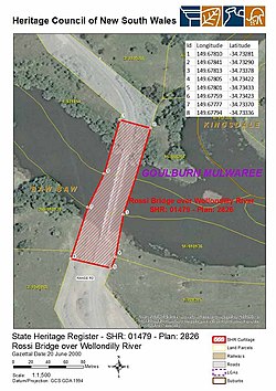
The Rossi Bridge over the
Wollondilly River was listed on the
428:
The bridge is a good example of the 27-metre (90 ft)
2035:
Buildings and structures in
Goulburn, New South Wales
1981:
1925:
1573:
1437:
1176:
990:
910:
331:
315:
307:
299:
291:
283:
275:
266:
251:
233:
225:
217:
212:
198:
190:
179:
171:
163:
155:
147:
137:
132:
122:
114:
99:
89:
81:
42:
23:
837:This Knowledge article was originally based on
887:
540:
538:
536:
534:
532:
8:
953:Pacific Motorway (Brisbane–Brunswick Heads)
894:
880:
872:
615:"Government Gazette Tenders and Contracts"
20:
556:Department of Planning & Environment
2040:New South Wales State Heritage Register
843:New South Wales State Heritage Register
551:New South Wales State Heritage Register
528:
457:New South Wales State Heritage Register
372:New South Wales State Heritage Register
546:"Rossi Bridge over Wollondilly River"
314:
306:
298:
290:
282:
274:
265:
7:
362:, Australia. The bridge is owned by
18:Bridge in New South Wales, Australia
963:Pacific Motorway (Sydney–Newcastle)
867:Rossi Bridge over Wollondilly River
839:Rossi Bridge over Wollondilly River
350:that carries Range Road across the
344:Rossi Bridge over Wollondilly River
279:Rossi Bridge over Wollondilly River
25:Rossi Bridge over Wollondilly River
620:New South Wales Government Gazette
221:J. J. Taylor and H. F. Littleproud
14:
644:The Goulburn Herald and Chronicle
269:New South Wales Heritage Register
2020:1899 establishments in Australia
1423:
1413:
1403:
1393:
1383:
1373:
1363:
1353:
1343:
1333:
1323:
1313:
1303:
1298:
1288:
1278:
1268:
1258:
1248:
1238:
1228:
1218:
1208:
1203:
1193:
1183:
1162:
1152:
1142:
1137:
1132:
1122:
1112:
1102:
1092:
1082:
1077:
1067:
1062:
1052:
1047:
1037:
1027:
1017:
1007:
997:
981:
967:
957:
947:
937:
927:
917:
902:Road infrastructure in regional
860:
832:
568:
499:
485:
471:
408:, who had submitted a tender of
31:
2045:Road bridges in New South Wales
199:
180:
1:
817:National Library of Australia
793:National Library of Australia
769:National Library of Australia
745:National Library of Australia
721:National Library of Australia
697:National Library of Australia
673:National Library of Australia
649:National Library of Australia
625:National Library of Australia
601:National Library of Australia
1653:Fitzgerald (Raymond Terrace)
852:, accessed on 2 June 2018.
841:, entry number 01479 in the
517:List of bridges in Australia
2050:Wooden bridges in Australia
1098:Newcastle Inner City Bypass
812:Goulburn Evening Penny Post
764:Goulburn Evening Penny Post
596:Goulburn Evening Penny Post
2066:
167:106.1 metres (348 ft)
2030:Bridges completed in 1899
1895:Murrumbidgee (Carrathool)
1688:Hampden (Kangaroo Valley)
979:
788:The Sydney Morning Herald
692:The Sydney Morning Herald
668:The Sydney Morning Herald
336:
327:
323:
262:
30:
1858:Williams (Clarence Town)
175:27.4 metres (90 ft)
1409:Snowy Mountains Highway
507:Australian roads portal
382:Rossi's Crossing was a
1833:Tea Gardens-Hawks Nest
639:"LOCAL AND PROVINCIAL"
479:New South Wales portal
370:. It was added to the
366:. It is also known as
287:State heritage (built)
1888:Hampden (Wagga Wagga)
1728:MacDonald (St Albans)
1648:Fitzgearld (Aberdeen)
1525:Murray Valley Highway
1033:Great Western Highway
1023:Central Coast Highway
869:at Wikimedia Commons
346:is a heritage-listed
1873:Yowaka (Greigs Flat)
1550:Solitary Islands Way
1490:Goulburn-Oberon Road
1455:Bathurst-Ilford Road
687:"GOVERNMENT NOTICES"
66:34.7336°S 149.6780°E
2025:Allan truss bridges
1560:Wombeyan Caves Road
1399:Silver City Highway
1244:Castlereagh Highway
1108:Newcastle Link Road
1088:New England Highway
1058:Mid-Western Highway
740:The Goulburn Herald
716:The Goulburn Herald
62: /
37:Heritage boundaries
1902:Old Cobram-Barooga
1723:Lennox (Glenbrook)
1520:Macleay Valley Way
1510:Jenolan Caves Road
1339:Lachlan Valley Way
1234:Burley Griffin Way
1199:Bells Line of Road
493:Engineering portal
300:Reference no.
255:An earlier bridge
71:-34.7336; 149.6780
2007:
2006:
1926:Vehicular ferries
1853:Victoria (Picton)
1718:Karuah (Monkerai)
1545:Remembrance Drive
1475:Carnarvon Highway
1470:Camden Valley Way
1465:Bylong Valley Way
1309:Kamilaroi Highway
1043:Illawarra Highway
943:Hunter Expressway
865:Media related to
459:on 20 June 2000.
374:on 20 June 2000.
364:Transport for NSW
352:Wollondilly River
340:
339:
257:(details unknown)
234:Construction cost
156:Pier construction
127:Transport for NSW
94:Wollondilly River
2057:
1868:Wollombi (Bulga)
1580:(disused/former)
1555:Thunderbolts Way
1535:Old Hume Highway
1500:Henry Parkes Way
1495:Henry Lawson Way
1427:
1426:
1417:
1416:
1407:
1406:
1397:
1396:
1389:Riverina Highway
1387:
1386:
1377:
1376:
1367:
1366:
1357:
1356:
1347:
1346:
1337:
1336:
1327:
1326:
1317:
1316:
1307:
1306:
1302:
1301:
1292:
1291:
1282:
1281:
1272:
1271:
1262:
1261:
1252:
1251:
1242:
1241:
1232:
1231:
1222:
1221:
1212:
1211:
1207:
1206:
1197:
1196:
1187:
1186:
1166:
1165:
1156:
1155:
1146:
1145:
1141:
1140:
1136:
1135:
1126:
1125:
1116:
1115:
1106:
1105:
1096:
1095:
1086:
1085:
1081:
1080:
1073:Mitchell Highway
1071:
1070:
1066:
1065:
1056:
1055:
1051:
1050:
1041:
1040:
1031:
1030:
1021:
1020:
1011:
1010:
1001:
1000:
985:
973:Princes Motorway
971:
970:
961:
960:
951:
950:
941:
940:
931:
930:
921:
920:
896:
889:
882:
873:
864:
836:
821:
820:
803:
797:
796:
783:"PUBLIC TENDERS"
779:
773:
772:
755:
749:
748:
735:"Rossi's Bridge"
731:
725:
724:
711:"ROSSI'S BRIDGE"
707:
701:
700:
683:
677:
676:
659:
653:
652:
635:
629:
628:
611:
605:
604:
591:"Rossi's Bridge"
587:
581:
572:
567:
565:
563:
542:
509:
504:
503:
495:
490:
489:
481:
476:
475:
474:
451:Heritage listing
368:Rossi's Crossing
319:Transport – Land
258:
226:Construction end
201:
182:
118:Rossi's Crossing
77:
76:
74:
73:
72:
67:
63:
60:
59:
58:
55:
35:
21:
2065:
2064:
2060:
2059:
2058:
2056:
2055:
2054:
2010:
2009:
2008:
2003:
1977:
1921:
1593:Balun Bindarray
1578:
1577:
1576:
1575:
1569:
1565:Yass Valley Way
1515:Kosciuszko Road
1433:
1424:
1414:
1404:
1394:
1384:
1374:
1364:
1354:
1344:
1334:
1324:
1314:
1304:
1299:
1289:
1279:
1269:
1259:
1249:
1239:
1229:
1224:Bruxner Highway
1219:
1209:
1204:
1194:
1184:
1172:
1163:
1158:Princes Highway
1153:
1148:Pacific Highway
1143:
1138:
1133:
1128:Olympic Highway
1123:
1113:
1103:
1093:
1083:
1078:
1068:
1063:
1053:
1048:
1038:
1028:
1018:
1008:
1003:Barrier Highway
998:
986:
977:
968:
958:
948:
938:
928:
923:Federal Highway
918:
906:
904:New South Wales
900:
858:
830:
825:
824:
805:
804:
800:
781:
780:
776:
757:
756:
752:
733:
732:
728:
709:
708:
704:
685:
684:
680:
661:
660:
656:
637:
636:
632:
613:
612:
608:
589:
588:
584:
561:
559:
544:
543:
530:
525:
513:
512:
505:
498:
491:
484:
477:
472:
470:
465:
453:
426:
380:
360:New South Wales
271:
256:
133:Characteristics
108:New South Wales
70:
68:
64:
61:
56:
53:
51:
49:
48:
38:
26:
19:
12:
11:
5:
2063:
2061:
2053:
2052:
2047:
2042:
2037:
2032:
2027:
2022:
2012:
2011:
2005:
2004:
2002:
2001:
1996:
1991:
1985:
1983:
1979:
1978:
1976:
1975:
1970:
1965:
1960:
1955:
1950:
1945:
1943:Lower Portland
1940:
1935:
1933:Berowra Waters
1929:
1927:
1923:
1922:
1920:
1919:
1912:
1905:
1898:
1891:
1884:
1876:
1875:
1870:
1865:
1860:
1855:
1850:
1845:
1840:
1835:
1830:
1825:
1820:
1815:
1810:
1805:
1800:
1795:
1794:
1793:
1788:
1783:
1778:
1770:
1765:
1760:
1755:
1750:
1745:
1743:Macleay Valley
1740:
1735:
1730:
1725:
1720:
1715:
1710:
1705:
1700:
1695:
1690:
1685:
1680:
1675:
1670:
1665:
1663:George Chaffey
1660:
1655:
1650:
1645:
1640:
1635:
1630:
1628:Crankies Plain
1625:
1620:
1615:
1610:
1605:
1600:
1595:
1590:
1584:
1582:
1571:
1570:
1568:
1567:
1562:
1557:
1552:
1547:
1542:
1537:
1532:
1530:O'Connell Road
1527:
1522:
1517:
1512:
1507:
1505:Irrigation Way
1502:
1497:
1492:
1487:
1482:
1477:
1472:
1467:
1462:
1457:
1452:
1447:
1441:
1439:
1435:
1434:
1432:
1431:
1421:
1419:Summerland Way
1411:
1401:
1391:
1381:
1371:
1361:
1359:Monaro Highway
1351:
1349:Memorial Drive
1341:
1331:
1321:
1311:
1296:
1294:Gwydir Highway
1286:
1284:Goldfields Way
1276:
1274:Golden Highway
1266:
1264:Fossickers Way
1256:
1246:
1236:
1226:
1216:
1201:
1191:
1180:
1178:
1177:Minor highways
1174:
1173:
1171:
1170:
1160:
1150:
1130:
1120:
1118:Newell Highway
1110:
1100:
1090:
1075:
1060:
1045:
1035:
1025:
1015:
1013:Barton Highway
1005:
994:
992:
991:Major highways
988:
987:
980:
978:
976:
975:
965:
955:
945:
935:
925:
914:
912:
908:
907:
901:
899:
898:
891:
884:
876:
857:
856:External links
854:
829:
826:
823:
822:
807:"A.H.C. Guild"
798:
774:
750:
726:
702:
678:
654:
630:
606:
582:
527:
526:
524:
521:
520:
519:
511:
510:
496:
482:
467:
466:
464:
461:
452:
449:
425:
422:
379:
376:
338:
337:
334:
333:
329:
328:
325:
324:
321:
320:
317:
313:
312:
309:
305:
304:
301:
297:
296:
293:
289:
288:
285:
281:
280:
277:
273:
272:
267:
264:
263:
260:
259:
253:
249:
248:
235:
231:
230:
227:
223:
222:
219:
218:Fabrication by
215:
214:
210:
209:
206:
196:
195:
192:
191:Piers in water
188:
187:
184:
177:
176:
173:
169:
168:
165:
161:
160:
157:
153:
152:
149:
145:
144:
139:
135:
134:
130:
129:
124:
120:
119:
116:
112:
111:
101:
97:
96:
91:
87:
86:
83:
79:
78:
46:
40:
39:
36:
28:
27:
24:
17:
13:
10:
9:
6:
4:
3:
2:
2062:
2051:
2048:
2046:
2043:
2041:
2038:
2036:
2033:
2031:
2028:
2026:
2023:
2021:
2018:
2017:
2015:
2000:
1997:
1995:
1992:
1990:
1987:
1986:
1984:
1980:
1974:
1971:
1969:
1966:
1964:
1961:
1959:
1956:
1954:
1951:
1949:
1946:
1944:
1941:
1939:
1936:
1934:
1931:
1930:
1928:
1924:
1918:
1917:
1913:
1911:
1910:
1906:
1904:
1903:
1899:
1897:
1896:
1892:
1890:
1889:
1885:
1883:
1882:
1878:
1877:
1874:
1871:
1869:
1866:
1864:
1863:Wallaby Rocks
1861:
1859:
1856:
1854:
1851:
1849:
1846:
1844:
1841:
1839:
1838:Tourle Street
1836:
1834:
1831:
1829:
1826:
1824:
1821:
1819:
1816:
1814:
1811:
1809:
1806:
1804:
1801:
1799:
1796:
1792:
1789:
1787:
1784:
1782:
1779:
1777:
1774:
1773:
1771:
1769:
1766:
1764:
1761:
1759:
1756:
1754:
1753:Mooney Mooney
1751:
1749:
1746:
1744:
1741:
1739:
1738:McKanes Falls
1736:
1734:
1731:
1729:
1726:
1724:
1721:
1719:
1716:
1714:
1711:
1709:
1706:
1704:
1701:
1699:
1696:
1694:
1691:
1689:
1686:
1684:
1681:
1679:
1676:
1674:
1671:
1669:
1666:
1664:
1661:
1659:
1656:
1654:
1651:
1649:
1646:
1644:
1641:
1639:
1636:
1634:
1631:
1629:
1626:
1624:
1621:
1619:
1616:
1614:
1611:
1609:
1606:
1604:
1601:
1599:
1596:
1594:
1591:
1589:
1586:
1585:
1583:
1581:
1572:
1566:
1563:
1561:
1558:
1556:
1553:
1551:
1548:
1546:
1543:
1541:
1538:
1536:
1533:
1531:
1528:
1526:
1523:
1521:
1518:
1516:
1513:
1511:
1508:
1506:
1503:
1501:
1498:
1496:
1493:
1491:
1488:
1486:
1483:
1481:
1478:
1476:
1473:
1471:
1468:
1466:
1463:
1461:
1458:
1456:
1453:
1451:
1448:
1446:
1443:
1442:
1440:
1436:
1430:
1429:Waterfall Way
1422:
1420:
1412:
1410:
1402:
1400:
1392:
1390:
1382:
1380:
1372:
1370:
1369:Oxley Highway
1362:
1360:
1352:
1350:
1342:
1340:
1332:
1330:
1329:Kings Highway
1322:
1320:
1312:
1310:
1297:
1295:
1287:
1285:
1277:
1275:
1267:
1265:
1257:
1255:
1247:
1245:
1237:
1235:
1227:
1225:
1217:
1215:
1214:Big River Way
1202:
1200:
1192:
1190:
1182:
1181:
1179:
1175:
1169:
1168:Sturt Highway
1161:
1159:
1151:
1149:
1131:
1129:
1121:
1119:
1111:
1109:
1101:
1099:
1091:
1089:
1076:
1074:
1061:
1059:
1046:
1044:
1036:
1034:
1026:
1024:
1016:
1014:
1006:
1004:
996:
995:
993:
989:
984:
974:
966:
964:
956:
954:
946:
944:
936:
934:
926:
924:
916:
915:
913:
909:
905:
897:
892:
890:
885:
883:
878:
877:
874:
870:
868:
863:
855:
853:
851:
848:
844:
840:
835:
827:
818:
814:
813:
808:
802:
799:
794:
790:
789:
784:
778:
775:
770:
766:
765:
760:
759:"Advertising"
754:
751:
746:
742:
741:
736:
730:
727:
722:
718:
717:
712:
706:
703:
698:
694:
693:
688:
682:
679:
674:
670:
669:
664:
658:
655:
650:
646:
645:
640:
634:
631:
626:
622:
621:
616:
610:
607:
602:
598:
597:
592:
586:
583:
579:
576:
571:
557:
553:
552:
547:
541:
539:
537:
535:
533:
529:
522:
518:
515:
514:
508:
502:
497:
494:
488:
483:
480:
469:
462:
460:
458:
450:
448:
444:
442:
439:
434:
431:
423:
421:
419:
415:
411:
407:
402:
399:
397:
393:
389:
385:
377:
375:
373:
369:
365:
361:
357:
353:
349:
345:
335:
330:
326:
322:
318:
310:
302:
294:
286:
278:
276:Official name
270:
261:
254:
250:
247:
243:
239:
236:
232:
228:
224:
220:
216:
211:
207:
205:
197:
193:
189:
185:
178:
174:
170:
166:
162:
158:
154:
150:
146:
143:
140:
136:
131:
128:
125:
121:
117:
115:Other name(s)
113:
109:
105:
102:
98:
95:
92:
88:
84:
80:
75:
47:
45:
41:
34:
29:
22:
16:
1999:Tugun Bypass
1914:
1907:
1900:
1893:
1886:
1879:
1807:
1673:Goodradigbee
1643:The Entrance
1579:
1574:Road bridges
1485:Giinagay Way
1460:Bucketts Way
1254:Cobb Highway
933:Hume Highway
859:
831:
810:
801:
786:
777:
762:
753:
738:
729:
714:
705:
690:
681:
666:
657:
642:
633:
618:
609:
594:
585:
560:. Retrieved
549:
454:
445:
427:
403:
400:
381:
367:
343:
341:
295:20 June 2000
172:Longest span
164:Total length
15:
1963:Webbs Creek
1909:Old Mildura
1608:Bland Creek
1438:Other roads
1379:Picton Road
828:Attribution
447:landscape.
430:Allan truss
424:Description
348:road bridge
311:Road Bridge
142:Allan truss
110:, Australia
69: /
57:149°40′41″E
44:Coordinates
2014:Categories
1708:Holt-Bragg
1588:Abbotsford
1540:Putty Road
1480:Escort Way
1445:Alpine Way
1319:Kidman Way
1189:Appin Road
663:"Untitled"
523:References
292:Designated
85:Range Road
54:34°44′01″S
1994:St Helena
1948:Sackville
1813:Sea Cliff
1791:Tooleybuc
1781:Swan Hill
1733:McFarlane
1450:Barry Way
911:Motorways
847:CC-BY 4.0
575:CC-BY 4.0
396:Crookwell
1968:Wisemans
1938:Lawrence
1823:Stockton
1786:Tocumwal
1768:Mungindi
1713:Junction
1668:Glennies
1618:Coonamit
1613:Colemans
1603:Bethanga
558:. H01479
463:See also
412:2,545 17
390:towards
388:Goulburn
356:Goulburn
332:Location
316:Category
252:Replaces
240:2,545 17
183:of spans
148:Material
104:Goulburn
1982:Tunnels
1958:Ulmarra
1916:Thornes
1881:Denison
1843:Towamba
1818:Sheahan
1772:Murray
1763:Mulwala
1758:Morpeth
1683:Harwood
1678:Grafton
1658:Gee Gee
1638:Dunmore
1623:Cooreei
1598:Beckers
850:licence
578:licence
438:granite
378:History
213:History
159:Granite
90:Crosses
82:Carries
1989:Cudgen
1953:Speewa
1828:Taemas
1776:Barham
1748:Martin
1703:Hinton
1698:Hexham
1633:Dennis
562:2 June
151:Timber
138:Design
100:Locale
1973:Wymah
1808:Rossi
1798:Nowra
441:piers
392:Wheeo
303:01479
204:lanes
123:Owner
1848:Vacy
564:2018
433:span
406:Bega
394:and
384:ford
342:The
308:Type
284:Type
229:1899
1803:Rip
1693:Hay
202:of
200:No.
181:No.
2016::
809:.
785:.
761:.
737:.
713:.
689:.
665:.
641:.
617:.
593:.
554:.
548:.
531:^
420:.
410:A£
358:,
354:,
238:A£
106:,
895:e
888:t
881:v
819:.
795:.
771:.
747:.
723:.
699:.
675:.
651:.
627:.
603:.
580:.
566:.
418:d
416:5
414:s
246:d
244:5
242:s
208:1
194:4
186:5
Text is available under the Creative Commons Attribution-ShareAlike License. Additional terms may apply.