63:
88:
42:
270:
2802:
256:
2854:
2828:
335:
95:
70:
742:
1111:
471:
453:
410:
383:
2527:
1480:
1445:
2899:
1144:
425:
2337:
151:
2307:
1230:
822:
415:
2773:
2387:
2010:
1450:
420:
2507:
1610:
524:
2392:
1670:
900:
812:
787:
580:
2928:
2322:
2215:
1985:
1740:
1640:
752:
486:
309:
2220:
1101:
792:
777:
712:
435:
376:
2155:
1073:
2933:
2813:
2589:
2462:
1540:
1460:
1370:
1093:
802:
757:
747:
737:
509:
186:
87:
1830:
2758:
2297:
2125:
1940:
1565:
1545:
1425:
1395:
1300:
1285:
1280:
772:
727:
707:
651:
641:
481:
2892:
2447:
2427:
2412:
2225:
1720:
1630:
1490:
1440:
1420:
1335:
807:
767:
722:
717:
392:
600:
2432:
2140:
2135:
1910:
1835:
1725:
1665:
1645:
1600:
1435:
1235:
1200:
782:
646:
514:
300:
2832:
1345:
1000:
560:
2820:
2806:
2715:
2659:
2512:
2287:
2265:
1930:
1925:
1805:
1745:
1550:
1515:
1500:
1470:
1315:
732:
491:
369:
62:
1590:
1005:
1820:
1730:
1715:
1570:
1530:
1415:
1390:
1365:
1134:
797:
501:
1650:
2517:
2452:
2090:
2045:
1705:
1655:
1475:
1320:
835:
762:
623:
1290:
2938:
2885:
2497:
2332:
2240:
2235:
2210:
2085:
1920:
1635:
1555:
1525:
1510:
1410:
1380:
1375:
1270:
1215:
870:
702:
547:
305:
260:
241:
2733:
2245:
1815:
1050:
2918:
2260:
2250:
1995:
1845:
1790:
1680:
1485:
1325:
1210:
1030:
970:
965:
2230:
2195:
2190:
1245:
2923:
2482:
2467:
2352:
2317:
2165:
1560:
1405:
1310:
1265:
1260:
1945:
1465:
1400:
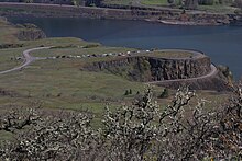
2654:
2634:
2546:
2362:
2292:
2110:
2105:
2075:
2050:
1905:
1900:
1880:
1785:
1770:
1735:
1250:
910:
890:
850:
661:
538:
518:
144:
2674:
1975:
1935:
2728:
2669:
2604:
2477:
2417:
2397:
2205:
2200:
2015:
2000:
1885:
1780:
1124:
1065:
955:
915:
1795:
1765:
1755:
2783:
2694:
2649:
2614:
2599:
2502:
2402:
2115:
1955:
1890:
1825:
1685:
1340:
1330:
1181:
1149:
1025:
980:
945:
605:
570:
2422:
1275:
2679:
2255:
2080:
2020:
1700:
1615:
1605:
1595:
960:
950:
925:
555:
461:
2689:
2624:
2492:
2130:
1915:
1385:
1154:
1040:
1015:
990:
935:
865:
860:
840:
692:
633:
590:
2644:
1690:
1520:
295:
2743:
2664:
1505:
273:
The upper portion of the park includes Rowena Crest, a viewpoint with interpretive signs, and Rowena
Plateau.
2738:
2723:
2532:
2522:
2160:
2145:
2055:
2040:
1980:
1675:
1220:
1020:
875:
845:
830:
585:
565:
2639:
2629:
1710:
2579:
2564:
2487:
2472:
2407:
1840:
1750:
1535:
1430:
1305:
1295:
895:
880:
595:
575:
245:
237:
226:
222:
2619:
2574:
2347:
1760:
1620:
1255:
1205:
1055:
1045:
1035:
995:
985:
975:
940:
930:
905:
444:
2120:
2861:
2684:
2609:
2569:
2559:
2554:
2327:
2150:
2100:
1960:
1895:
1875:
1860:
1625:
1495:
1172:
1129:
1010:
920:
885:
855:
674:
210:
202:
123:
2753:
2457:
2170:
2060:
339:
2342:
2312:
2302:
1775:
615:
137:
1990:
2357:
2030:
2005:
1970:
1455:
1139:
2382:
2065:
1850:
1695:
1240:
259:
The lower portion of the park includes a small lake, boat ramp, and the Rowena Loops of the
2180:
1965:
1078:
248:) climbs to the Rowena Crest, where there is an overlook, from the community of Rowena.
41:
2869:
2442:
2372:
2275:
206:
47:
269:
2912:
2763:
669:
255:
2095:
2070:
1580:
1355:
1190:
1119:
1083:
1660:
1225:
346:
2748:
1867:
214:
198:
166:
153:
2853:
2437:
361:
17:
334:
2865:
396:
218:
127:
268:
254:
365:
743:
Julia Butler Hansen Refuge for the
Columbian White-Tailed Deer
221:. It consists of several disjointed parcels of transected by
1079:
Steens
Mountain Cooperative Management and Protection Area
2873:
2772:
2714:
2707:
2588:
2545:
2371:
2274:
2179:
2029:
1859:
1804:
1579:
1354:
1189:
1180:
1171:
1110:
1092:
1064:
821:
691:
660:
632:
614:
546:
537:
500:
470:
452:
443:
434:
182:
143:
133:
119:
111:
34:
1130:Fossil Lake Area of Critical Environmental Concern
1145:South Slough National Estuarine Research Reserve
1102:List of Oregon's National Wild and Scenic Rivers
2893:
377:
8:
2900:
2886:
2711:
1186:
1177:
688:
543:
449:
440:
384:
370:
362:
232:The south-easternmost parcel includes the
31:
310:United States Department of the Interior
94:
69:
287:
2814:Oregon Parks and Recreation Department
187:Oregon Parks and Recreation Department
1084:Yaquina Head Outstanding Natural Area
7:
2850:
2848:
2827:
411:National Register of Historic Places
110:
515:Newberry National Volcanic Monument
426:World Network of Biosphere Reserves
349:. Oregon State Parks and Recreation
301:Geographic Names Information System
27:State park in Oregon, United States
1074:Cascade–Siskiyou National Monument
25:
1135:Lost Forest Research Natural Area
2852:
2826:
2801:
2800:
333:
118:
93:
86:
68:
61:
40:
2929:Historic Columbia River Highway
2226:Klamath Falls – Lakeview Forest
1921:Historic Columbia River Highway
1094:National Wild and Scenic Rivers
306:United States Geological Survey
261:Historic Columbia River Highway
242:Historic Columbia River Highway
181:
1:
2934:Parks in Wasco County, Oregon
1471:L. Presley & Vera C. Gill
102:Show map of the United States
2872:. You can help Knowledge by
2868:state location article is a
2528:Wallowa Lake Highway Forest
1346:Wilson River Highway Forest
1231:Clay Myers at Whalen Island
1125:Christmas Valley Sand Dunes
1066:National Conservation Lands
416:National Historic Landmarks
2955:
2847:
2784:Tualatin Hills Nature Park
1150:Upper and Lower Table Rock
421:National Natural Landmarks
2796:
687:
634:National recreation areas
403:
167:45.675676°N 121.2697945°W
55:
39:
1731:Port Orford Cedar Forest
1155:Wildwood Recreation Site
2774:Tualatin Hills Park and
2051:Blachly Mountain Forest
1671:Golden and Silver Falls
1651:Elk Creek Tunnel Forest
172:45.675676; -121.2697945
2939:Oregon geography stubs
2488:Pete French Round Barn
2388:Battle Mountain Forest
2241:Rough and Ready Forest
1971:Portland Women's Forum
1456:Heceta Head Lighthouse
274:
264:
227:Union Pacific Railroad
225:and the tracks of the
2919:State parks of Oregon
2503:Sumpter Valley Dredge
1641:Coquille Myrtle Grove
1611:Bolon Island Tideways
1466:Joaquin Miller Forest
1321:Sunset Highway Forest
1120:Cascade Head Preserve
1112:Other protected areas
272:
258:
2924:Columbia River Gorge
2655:Phillip W. Schneider
2393:Blue Mountain Forest
2338:Redmond–Bend Juniper
2333:Prineville Reservoir
2211:Illinois River Forks
1831:L. L. "Stub" Stewart
1291:Neahkahnie–Manzanita
675:Columbia River Gorge
581:Rogue River–Siskiyou
510:John Day Fossil Beds
342:at Wikimedia Commons
203:Columbia River Gorge
2776:Recreation District
2675:Snake River Islands
2261:Valley of the Rogue
2231:OC&E Woods Line
2196:Canyon Creek Forest
2171:Willamette Greenway
1636:Conde B. McCullough
1031:Strawberry Mountain
1001:Rogue–Umpqua Divide
971:North Fork Umatilla
966:North Fork John Day
616:National Grasslands
487:Lewis and Clark NHP
163: /
2353:The Cove Palisades
2246:Stage Coach Forest
2216:Jackson F. Kimball
2166:Willamette Mission
1741:Samuel H. Boardman
1566:Yachats Ocean Road
1546:Tokatee Klootchman
1461:Jessie M. Honeyman
1446:Governor Patterson
1286:Munson Creek Falls
1246:Elmer Feldenheimer
1006:Salmon–Huckleberry
502:National monuments
482:Fort Vancouver NHS
407:Heritage registers
347:"Mayer State Park"
296:"Mayer State Park"
275:
265:
77:Show map of Oregon
2881:
2880:
2842:
2841:
2792:
2791:
2703:
2702:
2541:
2540:
2508:Ukiah–Dale Forest
2363:White River Falls
2323:Peter Skene Ogden
2293:Cottonwood Canyon
2221:Joseph H. Stewart
1891:Bridal Veil Falls
1826:Government Island
1786:William M. Tugman
1776:Umpqua Lighthouse
1736:Port Orford Heads
1481:Muriel O. Ponsler
1421:Devils Punch Bowl
1396:Carl G. Washburne
1167:
1166:
1163:
1162:
1140:Sandy River Delta
911:Lower White River
891:Gearhart Mountain
871:Devil's Staircase
851:Bull of the Woods
813:William L. Finley
693:National Wildlife
683:
682:
533:
532:
472:National Historic
338:Media related to
279:
278:
192:
191:
134:Nearest city
50:from Rowena Crest
46:View east of the
16:(Redirected from
2946:
2902:
2895:
2888:
2856:
2849:
2830:
2829:
2804:
2803:
2712:
2463:Hilgard Junction
2448:Frenchglen Hotel
2428:Emigrant Springs
2206:Collier Memorial
2156:Thompson's Mills
2011:Vinzenz Lausmann
2001:Starvation Creek
1911:George W. Joseph
1851:Willamette Stone
1701:Maria C. Jackson
1591:Albert H. Powers
1541:Stonefield Beach
1187:
1178:
956:Mount Washington
916:Mark O. Hatfield
823:Wilderness areas
788:Three Arch Rocks
689:
548:National Forests
544:
450:
441:
386:
379:
372:
363:
358:
356:
354:
340:Mayer State Park
337:
321:
320:
318:
316:
292:
251:
250:
238:horseshoe curves
195:Mayer State Park
183:Operated by
178:
177:
175:
174:
173:
168:
164:
161:
160:
159:
156:
103:
97:
96:
90:
78:
72:
71:
65:
44:
35:Mayer State Park
32:
21:
2954:
2953:
2949:
2948:
2947:
2945:
2944:
2943:
2909:
2908:
2907:
2906:
2845:
2843:
2838:
2788:
2775:
2768:
2759:Smith and Bybee
2729:Cooper Mountain
2699:
2650:Lower Deschutes
2591:
2584:
2537:
2403:Catherine Creek
2374:
2367:
2308:Elliott Corbett
2298:Deschutes River
2277:
2270:
2191:Ben Hur Lampman
2182:
2175:
2126:Maud Williamson
2032:
2025:
1991:Shepperd's Dell
1966:Multnomah Falls
1941:Lewis and Clark
1866:
1862:
1855:
1807:
1800:
1686:Humbug Mountain
1666:Geisel Monument
1582:
1575:
1426:Driftwood Beach
1357:
1350:
1301:Oceanside Beach
1281:Manhattan Beach
1192:
1159:
1106:
1088:
1060:
1051:Wenaha–Tucannon
1026:Steens Mountain
981:Oregon Badlands
946:Mount Jefferson
817:
753:Lewis and Clark
694:
679:
656:
628:
610:
601:Wallowa–Whitman
529:
496:
474:Parks and Sites
473:
466:
430:
399:
393:Protected areas
390:
352:
350:
345:
330:
325:
324:
314:
312:
294:
293:
289:
284:
171:
169:
165:
162:
157:
154:
152:
150:
149:
107:
106:
105:
104:
101:
100:
99:
98:
81:
80:
79:
76:
75:
74:
73:
51:
28:
23:
22:
15:
12:
11:
5:
2952:
2950:
2942:
2941:
2936:
2931:
2926:
2921:
2911:
2910:
2905:
2904:
2897:
2890:
2882:
2879:
2878:
2857:
2840:
2839:
2837:
2836:
2824:
2817:
2810:
2797:
2794:
2793:
2790:
2789:
2787:
2786:
2780:
2778:
2770:
2769:
2767:
2766:
2761:
2756:
2751:
2746:
2741:
2736:
2731:
2726:
2720:
2718:
2709:
2705:
2704:
2701:
2700:
2698:
2697:
2692:
2687:
2682:
2677:
2672:
2667:
2662:
2657:
2652:
2647:
2642:
2637:
2635:Jewell Meadows
2632:
2627:
2622:
2617:
2612:
2607:
2602:
2596:
2594:
2586:
2585:
2583:
2582:
2577:
2572:
2567:
2562:
2557:
2551:
2549:
2543:
2542:
2539:
2538:
2536:
2535:
2530:
2525:
2520:
2515:
2510:
2505:
2500:
2495:
2490:
2485:
2480:
2475:
2470:
2465:
2460:
2455:
2450:
2445:
2443:Fort Rock Cave
2440:
2435:
2430:
2425:
2423:Deadman's Pass
2420:
2415:
2413:Clyde Holliday
2410:
2405:
2400:
2395:
2390:
2385:
2379:
2377:
2369:
2368:
2366:
2365:
2360:
2355:
2350:
2345:
2340:
2335:
2330:
2325:
2320:
2315:
2310:
2305:
2300:
2295:
2290:
2285:
2282:
2280:
2272:
2271:
2269:
2268:
2266:Wolf Creek Inn
2263:
2258:
2253:
2248:
2243:
2238:
2233:
2228:
2223:
2218:
2213:
2208:
2203:
2198:
2193:
2187:
2185:
2177:
2176:
2174:
2173:
2168:
2163:
2158:
2153:
2148:
2143:
2138:
2133:
2128:
2123:
2118:
2113:
2108:
2103:
2098:
2093:
2088:
2083:
2081:Elijah Bristow
2078:
2073:
2068:
2063:
2058:
2053:
2048:
2043:
2037:
2035:
2027:
2026:
2024:
2023:
2018:
2013:
2008:
2003:
1998:
1993:
1988:
1983:
1978:
1973:
1968:
1963:
1958:
1953:
1948:
1943:
1938:
1933:
1928:
1923:
1918:
1913:
1908:
1903:
1898:
1893:
1888:
1883:
1878:
1872:
1870:
1857:
1856:
1854:
1853:
1848:
1843:
1838:
1833:
1828:
1823:
1818:
1816:Banks–Vernonia
1812:
1810:
1802:
1801:
1799:
1798:
1793:
1788:
1783:
1778:
1773:
1768:
1763:
1758:
1753:
1748:
1743:
1738:
1733:
1728:
1723:
1721:Paradise Point
1718:
1713:
1708:
1703:
1698:
1693:
1688:
1683:
1678:
1673:
1668:
1663:
1658:
1653:
1648:
1643:
1638:
1633:
1631:Cape Sebastian
1628:
1623:
1618:
1616:Bullards Beach
1613:
1608:
1603:
1598:
1596:Alfred A. Loeb
1593:
1587:
1585:
1577:
1576:
1574:
1573:
1568:
1563:
1558:
1556:Whale Watching
1553:
1548:
1543:
1538:
1533:
1528:
1523:
1518:
1513:
1508:
1503:
1498:
1493:
1491:Neskowin Beach
1488:
1483:
1478:
1473:
1468:
1463:
1458:
1453:
1451:H.B. Van Duzer
1448:
1443:
1441:Gleneden Beach
1438:
1433:
1428:
1423:
1418:
1413:
1408:
1403:
1398:
1393:
1388:
1383:
1378:
1373:
1368:
1362:
1360:
1352:
1351:
1349:
1348:
1343:
1338:
1336:Tolovana Beach
1333:
1328:
1323:
1318:
1313:
1311:Rockaway Beach
1308:
1303:
1298:
1293:
1288:
1283:
1278:
1273:
1268:
1263:
1261:Gearhart Ocean
1258:
1253:
1248:
1243:
1238:
1233:
1228:
1223:
1218:
1213:
1208:
1203:
1197:
1195:
1184:
1175:
1169:
1168:
1165:
1164:
1161:
1160:
1158:
1157:
1152:
1147:
1142:
1137:
1132:
1127:
1122:
1116:
1114:
1108:
1107:
1105:
1104:
1098:
1096:
1090:
1089:
1087:
1086:
1081:
1076:
1070:
1068:
1062:
1061:
1059:
1058:
1053:
1048:
1043:
1038:
1033:
1028:
1023:
1018:
1013:
1008:
1003:
998:
993:
988:
983:
978:
973:
968:
963:
961:Mountain Lakes
958:
953:
951:Mount Thielsen
948:
943:
938:
933:
928:
926:Middle Santiam
923:
918:
913:
908:
903:
898:
893:
888:
883:
878:
873:
868:
863:
858:
853:
848:
843:
838:
833:
827:
825:
819:
818:
816:
815:
810:
805:
800:
795:
793:Tualatin River
790:
785:
780:
778:Oregon Islands
775:
770:
765:
760:
755:
750:
745:
740:
735:
730:
725:
720:
715:
713:Baskett Slough
710:
705:
699:
697:
685:
684:
681:
680:
678:
677:
672:
666:
664:
658:
657:
655:
654:
649:
644:
638:
636:
630:
629:
627:
626:
620:
618:
612:
611:
609:
608:
603:
598:
593:
588:
583:
578:
573:
568:
563:
561:Fremont–Winema
558:
552:
550:
541:
535:
534:
531:
530:
528:
527:
522:
512:
506:
504:
498:
497:
495:
494:
489:
484:
478:
476:
468:
467:
465:
464:
458:
456:
454:National Parks
447:
438:
432:
431:
429:
428:
423:
418:
413:
408:
404:
401:
400:
391:
389:
388:
381:
374:
366:
360:
359:
343:
329:
328:External links
326:
323:
322:
286:
285:
283:
280:
277:
276:
266:
236:, a series of
207:Rowena, Oregon
190:
189:
184:
180:
179:
147:
141:
140:
135:
131:
130:
121:
117:
116:
113:
109:
108:
92:
91:
85:
84:
83:
82:
67:
66:
60:
59:
58:
57:
56:
53:
52:
48:Columbia River
45:
37:
36:
26:
24:
14:
13:
10:
9:
6:
4:
3:
2:
2951:
2940:
2937:
2935:
2932:
2930:
2927:
2925:
2922:
2920:
2917:
2916:
2914:
2903:
2898:
2896:
2891:
2889:
2884:
2883:
2877:
2875:
2871:
2867:
2863:
2858:
2855:
2851:
2846:
2835:
2834:
2825:
2823:
2822:
2818:
2816:
2815:
2811:
2809:
2808:
2799:
2798:
2795:
2785:
2782:
2781:
2779:
2777:
2771:
2765:
2764:Mount Talbert
2762:
2760:
2757:
2755:
2752:
2750:
2747:
2745:
2742:
2740:
2737:
2735:
2732:
2730:
2727:
2725:
2722:
2721:
2719:
2717:
2713:
2710:
2706:
2696:
2693:
2691:
2688:
2686:
2683:
2681:
2678:
2676:
2673:
2671:
2670:Sauvie Island
2668:
2666:
2663:
2661:
2658:
2656:
2653:
2651:
2648:
2646:
2643:
2641:
2638:
2636:
2633:
2631:
2628:
2626:
2623:
2621:
2618:
2616:
2613:
2611:
2608:
2606:
2603:
2601:
2598:
2597:
2595:
2593:
2587:
2581:
2578:
2576:
2573:
2571:
2568:
2566:
2563:
2561:
2558:
2556:
2553:
2552:
2550:
2548:
2544:
2534:
2533:Wallowa River
2531:
2529:
2526:
2524:
2521:
2519:
2516:
2514:
2511:
2509:
2506:
2504:
2501:
2499:
2496:
2494:
2491:
2489:
2486:
2484:
2481:
2479:
2476:
2474:
2471:
2469:
2468:Kam Wah Chung
2466:
2464:
2461:
2459:
2456:
2454:
2451:
2449:
2446:
2444:
2441:
2439:
2436:
2434:
2433:Farewell Bend
2431:
2429:
2426:
2424:
2421:
2419:
2418:Crooked Creek
2416:
2414:
2411:
2409:
2406:
2404:
2401:
2399:
2396:
2394:
2391:
2389:
2386:
2384:
2381:
2380:
2378:
2376:
2370:
2364:
2361:
2359:
2356:
2354:
2351:
2349:
2346:
2344:
2341:
2339:
2336:
2334:
2331:
2329:
2326:
2324:
2321:
2319:
2316:
2314:
2311:
2309:
2306:
2304:
2301:
2299:
2296:
2294:
2291:
2289:
2286:
2284:
2283:
2281:
2279:
2273:
2267:
2264:
2262:
2259:
2257:
2254:
2252:
2249:
2247:
2244:
2242:
2239:
2237:
2234:
2232:
2229:
2227:
2224:
2222:
2219:
2217:
2214:
2212:
2209:
2207:
2204:
2202:
2199:
2197:
2194:
2192:
2189:
2188:
2186:
2184:
2178:
2172:
2169:
2167:
2164:
2162:
2159:
2157:
2154:
2152:
2151:State Capitol
2149:
2147:
2144:
2142:
2141:Sarah Helmick
2139:
2137:
2136:North Santiam
2134:
2132:
2131:Molalla River
2129:
2127:
2124:
2122:
2119:
2117:
2114:
2112:
2109:
2107:
2104:
2102:
2099:
2097:
2094:
2092:
2089:
2087:
2084:
2082:
2079:
2077:
2074:
2072:
2069:
2067:
2064:
2062:
2059:
2057:
2054:
2052:
2049:
2047:
2044:
2042:
2039:
2038:
2036:
2034:
2028:
2022:
2019:
2017:
2014:
2012:
2009:
2007:
2004:
2002:
1999:
1997:
1994:
1992:
1989:
1987:
1984:
1982:
1979:
1977:
1974:
1972:
1969:
1967:
1964:
1962:
1959:
1957:
1954:
1952:
1949:
1947:
1946:Lindsey Creek
1944:
1942:
1939:
1937:
1934:
1932:
1929:
1927:
1924:
1922:
1919:
1917:
1916:Guy W. Talbot
1914:
1912:
1909:
1907:
1904:
1902:
1899:
1897:
1894:
1892:
1889:
1887:
1884:
1882:
1879:
1877:
1874:
1873:
1871:
1869:
1864:
1858:
1852:
1849:
1847:
1844:
1842:
1839:
1837:
1836:Mary S. Young
1834:
1832:
1829:
1827:
1824:
1822:
1819:
1817:
1814:
1813:
1811:
1809:
1803:
1797:
1794:
1792:
1789:
1787:
1784:
1782:
1781:Umpqua Myrtle
1779:
1777:
1774:
1772:
1769:
1767:
1764:
1762:
1759:
1757:
1754:
1752:
1749:
1747:
1744:
1742:
1739:
1737:
1734:
1732:
1729:
1727:
1724:
1722:
1719:
1717:
1714:
1712:
1709:
1707:
1704:
1702:
1699:
1697:
1694:
1692:
1689:
1687:
1684:
1682:
1679:
1677:
1674:
1672:
1669:
1667:
1664:
1662:
1659:
1657:
1654:
1652:
1649:
1647:
1646:Crissey Field
1644:
1642:
1639:
1637:
1634:
1632:
1629:
1627:
1624:
1622:
1619:
1617:
1614:
1612:
1609:
1607:
1604:
1602:
1601:Arizona Beach
1599:
1597:
1594:
1592:
1589:
1588:
1586:
1584:
1578:
1572:
1569:
1567:
1564:
1562:
1559:
1557:
1554:
1552:
1549:
1547:
1544:
1542:
1539:
1537:
1534:
1532:
1529:
1527:
1524:
1522:
1519:
1517:
1514:
1512:
1509:
1507:
1504:
1502:
1499:
1497:
1494:
1492:
1489:
1487:
1484:
1482:
1479:
1477:
1474:
1472:
1469:
1467:
1464:
1462:
1459:
1457:
1454:
1452:
1449:
1447:
1444:
1442:
1439:
1437:
1436:Fogarty Creek
1434:
1432:
1429:
1427:
1424:
1422:
1419:
1417:
1414:
1412:
1409:
1407:
1404:
1402:
1401:Collins Creek
1399:
1397:
1394:
1392:
1389:
1387:
1386:Beverly Beach
1384:
1382:
1379:
1377:
1374:
1372:
1369:
1367:
1364:
1363:
1361:
1359:
1353:
1347:
1344:
1342:
1339:
1337:
1334:
1332:
1329:
1327:
1324:
1322:
1319:
1317:
1314:
1312:
1309:
1307:
1304:
1302:
1299:
1297:
1294:
1292:
1289:
1287:
1284:
1282:
1279:
1277:
1274:
1272:
1269:
1267:
1266:Haystack Hill
1264:
1262:
1259:
1257:
1254:
1252:
1249:
1247:
1244:
1242:
1239:
1237:
1236:Del Rey Beach
1234:
1232:
1229:
1227:
1224:
1222:
1219:
1217:
1214:
1212:
1209:
1207:
1204:
1202:
1201:Arcadia Beach
1199:
1198:
1196:
1194:
1188:
1185:
1183:
1179:
1176:
1174:
1170:
1156:
1153:
1151:
1148:
1146:
1143:
1141:
1138:
1136:
1133:
1131:
1128:
1126:
1123:
1121:
1118:
1117:
1115:
1113:
1109:
1103:
1100:
1099:
1097:
1095:
1091:
1085:
1082:
1080:
1077:
1075:
1072:
1071:
1069:
1067:
1063:
1057:
1054:
1052:
1049:
1047:
1044:
1042:
1041:Three Sisters
1039:
1037:
1034:
1032:
1029:
1027:
1024:
1022:
1019:
1017:
1016:Soda Mountain
1014:
1012:
1009:
1007:
1004:
1002:
999:
997:
994:
992:
991:Roaring River
989:
987:
984:
982:
979:
977:
974:
972:
969:
967:
964:
962:
959:
957:
954:
952:
949:
947:
944:
942:
939:
937:
936:Monument Rock
934:
932:
929:
927:
924:
922:
919:
917:
914:
912:
909:
907:
904:
902:
899:
897:
894:
892:
889:
887:
884:
882:
879:
877:
874:
872:
869:
867:
866:Cummins Creek
864:
862:
861:Copper Salmon
859:
857:
854:
852:
849:
847:
844:
842:
841:Boulder Creek
839:
837:
834:
832:
829:
828:
826:
824:
820:
814:
811:
809:
806:
804:
803:Upper Klamath
801:
799:
796:
794:
791:
789:
786:
784:
781:
779:
776:
774:
771:
769:
766:
764:
761:
759:
758:Lower Klamath
756:
754:
751:
749:
748:Klamath Marsh
746:
744:
741:
739:
738:Hart Mountain
736:
734:
731:
729:
726:
724:
721:
719:
716:
714:
711:
709:
706:
704:
701:
700:
698:
696:
695:Refuge System
690:
686:
676:
673:
671:
670:Cape Perpetua
668:
667:
665:
663:
659:
653:
650:
648:
645:
643:
640:
639:
637:
635:
631:
625:
624:Crooked River
622:
621:
619:
617:
613:
607:
604:
602:
599:
597:
594:
592:
589:
587:
584:
582:
579:
577:
574:
572:
569:
567:
564:
562:
559:
557:
554:
553:
551:
549:
545:
542:
540:
536:
526:
523:
520:
516:
513:
511:
508:
507:
505:
503:
499:
493:
492:Nez Perce NHP
490:
488:
485:
483:
480:
479:
477:
475:
469:
463:
460:
459:
457:
455:
451:
448:
446:
442:
439:
437:
433:
427:
424:
422:
419:
417:
414:
412:
409:
406:
405:
402:
398:
394:
387:
382:
380:
375:
373:
368:
367:
364:
348:
344:
341:
336:
332:
331:
327:
311:
307:
303:
302:
297:
291:
288:
281:
271:
267:
262:
257:
253:
252:
249:
247:
246:U.S. Route 30
243:
240:by which the
239:
235:
230:
228:
224:
223:Interstate 84
220:
216:
212:
208:
204:
200:
196:
188:
185:
176:
148:
146:
142:
139:
136:
132:
129:
125:
122:
115:Public, state
114:
89:
64:
54:
49:
43:
38:
33:
30:
19:
2874:expanding it
2862:Wasco County
2859:
2844:
2831:
2819:
2812:
2805:
2695:Willow Creek
2615:E. E. Wilson
2600:Bridge Creek
2523:Wallowa Lake
2513:Unity Forest
2498:Succor Creek
2146:Silver Falls
2096:Fort Yamhill
2086:Erratic Rock
2071:Detroit Lake
1986:Seneca Fouts
1981:Rooster Rock
1950:
1931:Koberg Beach
1926:John B. Yeon
1906:Dalton Point
1796:Yoakam Point
1766:Sweet Myrtle
1756:Sisters Rock
1746:Seven Devils
1726:Pistol River
1676:Harris Beach
1551:W. B. Nelson
1411:Darlingtonia
1381:Beaver Creek
1316:Sunset Beach
1256:Fort Stevens
1251:Fishing Rock
1221:Cape Lookout
1216:Cape Kiwanda
1021:Spring Basin
901:Hells Canyon
876:Diamond Peak
846:Bridge Creek
836:Black Canyon
831:Badger Creek
773:Nestucca Bay
728:Cold Springs
708:Bandon Marsh
662:Scenic areas
652:Oregon Dunes
642:Hells Canyon
525:Oregon Caves
351:. Retrieved
313:. Retrieved
299:
290:
234:Rowena Loops
233:
231:
211:Wasco County
194:
193:
124:Wasco County
29:
18:Rowena Crest
2739:Graham Oaks
2690:White River
2680:Summer Lake
2473:Lake Owyhee
2328:Pilot Butte
2288:Cline Falls
2256:Tub Springs
2056:Bowers Rock
1976:Rocky Butte
1936:Lang Forest
1896:Crown Point
1863:River Gorge
1846:Tryon Creek
1841:Milo McIver
1821:Bonnie Lure
1751:Shore Acres
1716:Otter Point
1661:Floras Lake
1626:Cape Blanco
1571:Yaquina Bay
1536:South Beach
1531:Smelt Sands
1516:Rocky Creek
1501:Otter Crest
1416:Devils Lake
1366:Agate Beach
1326:Sitka Sedge
1306:Oswald West
1296:Nehalem Bay
1226:Cape Meares
896:Grassy Knob
881:Drift Creek
808:Wapato Lake
768:McKay Creek
723:Cape Meares
718:Bear Valley
462:Crater Lake
170: /
158:121°16′11″W
145:Coordinates
2913:Categories
2749:Oregon Zoo
2734:Glendoveer
2660:Prineville
2645:Ladd Marsh
2625:Fern Ridge
2605:Dean Creek
2518:Unity Lake
2493:Red Bridge
2453:Goose Lake
2348:Smith Rock
2116:Luckiamute
2091:Fall Creek
2031:Willamette
1956:McLoughlin
1886:Bonneville
1868:Mount Hood
1761:Sunset Bay
1706:McVay Rock
1696:Lone Ranch
1691:Hutchinson
1621:Cape Arago
1521:San Marine
1476:Lost Creek
1391:Boiler Bay
1341:Twin Rocks
1206:Bob Straub
1056:Wild Rogue
1046:Waldo Lake
1036:Table Rock
996:Rock Creek
986:Red Buttes
976:Opal Creek
941:Mount Hood
931:Mill Creek
906:Kalmiopsis
783:Siletz Bay
647:Mount Hood
606:Willamette
571:Mount Hood
282:References
215:U.S. state
199:state park
155:45°40′32″N
138:The Dalles
2724:Blue Lake
2665:Riverside
2580:Tillamook
2565:Gilchrist
2438:Fort Rock
2161:Washburne
2046:Bald Peak
2041:Alderwood
1961:Memaloose
1876:Ainsworth
1656:Face Rock
1526:Seal Rock
1511:Roads End
1506:Pritchard
1496:Ona Beach
1376:Beachside
1371:Alsea Bay
1276:John Yeon
1271:Hug Point
1011:Sky Lakes
921:Menagerie
886:Eagle Cap
856:Clackamas
733:Deer Flat
556:Deschutes
2821:Portland
2807:Category
2590:Wildlife
2575:Sun Pass
2458:Hat Rock
2408:Chandler
2251:TouVelle
2236:Prospect
2181:Southern
2066:Champoeg
2061:Cascadia
1996:Sheridan
1861:Columbia
1806:Portland
1791:Winchuck
1431:Ellmaker
798:Umatilla
591:Umatilla
120:Location
2833:Commons
2640:Klamath
2630:Irrigon
2620:Elkhorn
2570:Santiam
2560:Elliott
2555:Clatsop
2547:Forests
2483:Ontario
2373:Eastern
2343:Sisters
2313:La Pine
2276:Central
1681:Hoffman
1561:Yachats
1486:Neptune
1406:D River
1356:Central
1211:Bradley
763:Malheur
586:Siuslaw
566:Malheur
436:Federal
353:July 1,
315:July 1,
213:in the
205:, near
201:in the
2866:Oregon
2744:Howell
2685:Wenaha
2610:Denman
2375:Oregon
2358:Tumalo
2318:Ochoco
2278:Oregon
2183:Oregon
2121:Maples
2111:Lowell
2106:Jasper
2101:Holman
2076:Dexter
2033:Valley
2021:Wygant
2006:Viento
1901:Dabney
1881:Benson
1771:Umpqua
1606:Bandon
1331:Symons
703:Ankeny
596:Umpqua
576:Ochoco
397:Oregon
219:Oregon
128:Oregon
2860:This
2754:Oxbow
2716:Metro
2708:Local
2592:areas
2478:Minam
2398:Booth
2383:Bates
2201:Casey
2016:Wyeth
1951:Mayer
1808:Metro
1711:Ophir
1583:Coast
1581:South
1358:Coast
1241:Ecola
1193:Coast
1191:North
1182:Parks
1173:State
197:is a
2870:stub
2303:Dyer
539:USFS
519:USFS
355:2011
317:2011
112:Type
445:NPS
395:of
217:of
209:in
2915::
2864:,
308:,
304:.
298:.
229:.
126:,
2901:e
2894:t
2887:v
2876:.
1865:/
521:)
517:(
385:e
378:t
371:v
357:.
319:.
263:.
244:(
20:)
Text is available under the Creative Commons Attribution-ShareAlike License. Additional terms may apply.