71:
812:
56:
46:
670:
347:
83:
134:
342:
The county covers an area of 837.91 square kilometres (323.5 sq mi). As of 2006 its total population is 58,725, out of which the population of Słupca is 14,363, that of Zagórów is 2,932, and the rural population is 41,430.
1002:
758:
70:
811:
631:
455:
751:
96:
744:
582:
55:
324:
45:
624:
906:
946:
846:
831:
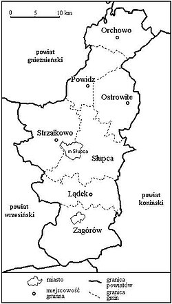
391:(one urban, one urban-rural and six rural). These are listed in the following table, in descending order of population.
82:
540:
771:
519:
316:
151:
997:
617:
279:
891:
146:
896:
911:
961:
951:
725:
441:
211:
976:
684:
462:
216:
971:
826:
372:
346:
669:
876:
926:
881:
841:
966:
901:
710:
526:
304:
196:
861:
736:
720:
483:
206:
941:
921:
916:
866:
851:
836:
700:
505:
376:
368:
360:
186:
991:
931:
886:
856:
705:
547:
191:
476:
336:
956:
871:
715:
568:
364:
201:
601:
261:
111:
98:
785:
658:
497:
422:
332:
328:
181:
161:
609:
561:
801:
791:
767:
331:, which lies 66 kilometres (41 mi) east of the regional capital
320:
312:
139:
33:
796:
640:
388:
345:
168:
311:) is a unit of territorial administration and local government (
740:
613:
292:
327:
passed in 1998. Its administrative seat and largest town is
323:. It came into being on January 1, 1999, as a result of the
350:
Map of the county 1957 from the State
Archive in Poznań
819:
778:
693:
677:
651:
288:
278:
270:
259:
251:
243:
238:
230:
225:
167:
157:
145:
127:
21:
339:, lying 16 km (10 mi) south of Słupca.
752:
625:
8:
16:County in Greater Poland Voivodeship, Poland
1003:Land counties of Greater Poland Voivodeship
759:
745:
737:
632:
618:
610:
18:
393:
602:Polish official population figures 2006
335:. The only other town in the county is
287:
277:
237:
234:837.91 km (323.52 sq mi)
224:
179:
156:
126:
91:
67:
39:
269:
258:
250:
242:
229:
166:
144:
79:
7:
387:The county is subdivided into eight
14:
810:
668:
132:
81:
69:
54:
44:
325:Polish local government reforms
75:Location within the voivodeship
1:
589:* seat not part of the gmina
359:Słupca County is bordered by
293:http://www.powiat-slupca.pl
1019:
772:Greater Poland Voivodeship
317:Greater Poland Voivodeship
93:Coordinates (Słupca):
808:
666:
588:
92:
80:
68:
40:
31:
383:Administrative division
176:Total 8 (incl. 1 urban)
351:
308:
255:70/km (180/sq mi)
847:Grodzisk Wielkopolski
355:Neighbouring counties
349:
252: • Density
87:Division into gminas
907:Ostrów Wielkopolski
379:to the north-west.
108: /
947:Środa Wielkopolska
832:Czarnków-Trzcianka
352:
271: • Rural
244: • Total
231: • Total
985:
984:
734:
733:
678:Urban-rural gmina
593:
592:
298:
297:
112:52.300°N 17.867°E
1010:
814:
761:
754:
747:
738:
726:Gmina Strzałkowo
672:
634:
627:
620:
611:
442:Gmina Strzałkowo
414:
407:
394:
375:to the west and
212:Gmina Strzałkowo
138:
136:
135:
123:
122:
120:
119:
118:
113:
109:
106:
105:
104:
101:
85:
73:
58:
48:
19:
1018:
1017:
1013:
1012:
1011:
1009:
1008:
1007:
988:
987:
986:
981:
815:
806:
774:
765:
735:
730:
711:Gmina Ostrowite
689:
673:
664:
647:
638:
607:
598:
527:Gmina Ostrowite
412:
411:
405:
404:
385:
373:Września County
357:
319:, west-central
309:powiat słupecki
221:
197:Gmina Ostrowite
178:
177:
133:
131:
116:
114:
110:
107:
102:
99:
97:
95:
94:
88:
76:
64:
63:
62:
61:
52:
51:
36:
27:
26:Powiat słupecki
24:
17:
12:
11:
5:
1016:
1014:
1006:
1005:
1000:
990:
989:
983:
982:
980:
979:
974:
969:
964:
959:
954:
949:
944:
939:
934:
929:
924:
919:
914:
909:
904:
899:
894:
889:
884:
879:
874:
869:
864:
859:
854:
849:
844:
839:
834:
829:
823:
821:
817:
816:
809:
807:
805:
804:
799:
794:
789:
782:
780:
776:
775:
766:
764:
763:
756:
749:
741:
732:
731:
729:
728:
723:
718:
713:
708:
703:
697:
695:
691:
690:
688:
687:
681:
679:
675:
674:
667:
665:
663:
662:
655:
653:
649:
648:
639:
637:
636:
629:
622:
614:
605:
604:
597:
594:
591:
590:
586:
585:
580:
577:
574:
571:
565:
564:
559:
556:
553:
550:
544:
543:
538:
535:
532:
529:
523:
522:
517:
514:
511:
508:
502:
501:
495:
492:
489:
486:
480:
479:
474:
471:
468:
465:
459:
458:
453:
450:
447:
444:
438:
437:
434:
431:
428:
425:
419:
418:
415:
408:
401:
398:
384:
381:
377:Gniezno County
371:to the south,
369:Pleszew County
363:to the north,
361:Mogilno County
356:
353:
296:
295:
290:
286:
285:
282:
276:
275:
272:
268:
267:
264:
257:
256:
253:
249:
248:
245:
241:
240:
236:
235:
232:
228:
227:
223:
222:
220:
219:
214:
209:
204:
199:
194:
189:
184:
175:
174:
173:
171:
165:
164:
159:
155:
154:
152:Greater Poland
149:
143:
142:
129:
125:
124:
117:52.300; 17.867
90:
89:
86:
78:
77:
74:
66:
65:
59:
53:
49:
43:
42:
41:
38:
37:
32:
29:
28:
25:
22:
15:
13:
10:
9:
6:
4:
3:
2:
1015:
1004:
1001:
999:
998:Słupca County
996:
995:
993:
978:
975:
973:
970:
968:
965:
963:
960:
958:
955:
953:
950:
948:
945:
943:
940:
938:
935:
933:
930:
928:
925:
923:
920:
918:
915:
913:
910:
908:
905:
903:
900:
898:
895:
893:
890:
888:
885:
883:
880:
878:
875:
873:
870:
868:
865:
863:
860:
858:
855:
853:
850:
848:
845:
843:
840:
838:
835:
833:
830:
828:
825:
824:
822:
820:Land counties
818:
813:
803:
800:
798:
795:
793:
790:
787:
784:
783:
781:
779:City counties
777:
773:
769:
762:
757:
755:
750:
748:
743:
742:
739:
727:
724:
722:
719:
717:
714:
712:
709:
707:
706:Gmina Orchowo
704:
702:
699:
698:
696:
692:
686:
685:Gmina Zagórów
683:
682:
680:
676:
671:
661:(urban gmina)
660:
657:
656:
654:
650:
646:
645:Słupca County
642:
635:
630:
628:
623:
621:
616:
615:
612:
608:
603:
600:
599:
595:
587:
584:
581:
578:
575:
572:
570:
567:
566:
563:
560:
557:
554:
551:
549:
548:Gmina Orchowo
546:
545:
542:
539:
536:
533:
530:
528:
525:
524:
521:
518:
515:
512:
509:
507:
504:
503:
499:
496:
493:
490:
487:
485:
482:
481:
478:
475:
472:
469:
466:
464:
463:Gmina Zagórów
461:
460:
457:
454:
451:
448:
445:
443:
440:
439:
435:
432:
429:
426:
424:
421:
420:
416:
409:
402:
399:
396:
395:
392:
390:
382:
380:
378:
374:
370:
367:to the east,
366:
362:
354:
348:
344:
340:
338:
334:
330:
326:
322:
318:
314:
310:
306:
302:
301:Słupca County
294:
291:
283:
281:
273:
265:
263:
260: •
254:
246:
233:
218:
217:Gmina Zagórów
215:
213:
210:
208:
205:
203:
200:
198:
195:
193:
192:Gmina Orchowo
190:
188:
185:
183:
180:
172:
170:
163:
160:
153:
150:
148:
141:
130:
121:
84:
72:
57:
47:
35:
30:
23:Słupca County
20:
936:
721:Gmina Słupca
716:Gmina Powidz
694:Rural gminas
644:
606:
569:Gmina Powidz
484:Gmina Słupca
467:urban-rural
386:
365:Konin County
358:
341:
300:
299:
207:Gmina Słupca
202:Gmina Powidz
60:Coat of arms
897:Nowy Tomyśl
701:Gmina Lądek
506:Gmina Lądek
187:Gmina Lądek
147:Voivodeship
115: /
992:Categories
912:Ostrzeszów
892:Międzychód
596:References
456:Strzałkowo
410:Population
280:Car plates
239:Population
962:Wągrowiec
952:Szamotuły
882:Krotoszyn
788:(capital)
541:Ostrowite
972:Września
967:Wolsztyn
902:Oborniki
827:Chodzież
768:Counties
922:Pleszew
877:Kościan
852:Jarocin
837:Gniezno
562:Orchowo
477:Zagórów
436:
433:14,363
337:Zagórów
289:Website
128:Country
103:17°52′E
100:52°18′N
977:Złotów
937:Słupca
932:Rawicz
927:Poznań
887:Leszno
857:Kalisz
842:Gostyń
802:Leszno
792:Kalisz
786:Poznań
659:Słupca
641:Gminas
583:Powidz
579:2,077
573:rural
558:3,892
552:rural
537:5,069
534:104.1
531:rural
516:5,660
510:rural
498:Słupca
494:8,974
491:144.9
488:rural
473:9,073
470:159.6
452:9,617
449:142.4
446:rural
427:urban
423:Słupca
413:(2006)
397:Gmina
389:gminas
333:Poznań
329:Słupca
321:Poland
313:powiat
305:Polish
274:41,430
266:17,295
247:58,725
182:Słupca
169:Gminas
162:Słupca
140:Poland
137:
34:County
957:Turek
872:Konin
862:Kępno
797:Konin
576:80.2
555:98.1
520:Lądek
513:98.3
430:10.3
417:Seat
400:Type
315:) in
262:Urban
942:Śrem
917:Piła
867:Koło
652:Seat
406:(km)
403:Area
226:Area
158:Seat
50:Flag
770:of
643:of
284:PSL
994::
500:*
307::
760:e
753:t
746:v
633:e
626:t
619:v
303:(
Text is available under the Creative Commons Attribution-ShareAlike License. Additional terms may apply.