61:
1388:
52:
604:
873:
756:
738:
593:
544:
536:
585:
612:
151:
1293:
779:
190:
767:
762:
749:
744:
142:
137:
1068:
357:, which opened in 1984. The tunnel is shared with Russia and was the longest within the Soviet Union upon its commissioning with a length of 3,730 m (2.32 mi). It is still the longest tunnel (partially) in Georgia. Yet, this feature has limited value in Georgia as the highway is not controlled by the Georgian government beyond Ergneti village near
25:
897:
851:
946:
814:
475:
attempted to prevent a direct rail or road connection between the South
Ossetian oblast and the North Ossetian republic fearing nationalist unity but eventually had to succumb to Moscow. The scope was to build a road that would be open year-round. Both the Ossetian and Georgian Military Roads are sensitive to snowdrift leading to seasonal closures. The
1077:
909:
196:
958:
162:
722:
1309:
124:
469:
via
Kazbegi. This lack of direct connections between the Ossetian communities on either side of the mountains triggered the Ossetian autonomous authorities to campaign for a railroad and later a road through the mountains. After a last attempt in the late 1940s for a railroad connection through the
647:
This point is also the confluence of the
Liakhvi and Patsa rivers and has one of the few highway feature highlights. The landmark 1929 Guftinsky bridge across the Patsa River is not in use anymore but is visible from the 1980s steel-concrete bridge which was built for the Transkam Highway. The old
630:
and is literally the lifeline of the self-declared republic. The
Transkam Highway is the only regular road in and out of the region as South Ossetian authorities keep crossing points to Tbilisi controlled Georgia closed for ordinary traffic. From the roadblock at Ergneti the road continues north
571:
river at a distance of a few kilometers. Even though the road is closed for through traffic into
Tskhinvali and South Ossetia, it has importance in the area just south of it with many Georgian communities near the boundary line. The highway connects them with the rest of Georgia. Just north from
474:
decreed in 1971 a road connection through Roki. Upgrading the existing
Mamison route with a tunnel was part of earlier surveys, but despite being geologically more advantageous this was dismissed in favour of the Roki variant which needed a shorter tunnel. Georgian Soviet authorities had long
635:
river and circumvents the centre of
Tskhinvali. After crossing the Liakhvi River the road heads north out of town and after 16 kilometres (9.9 mi) it reaches the small settlement Gupta. Here is the junction with the
412:
regained independence in 1991, the Soviet route designations were maintained until 1996 when the current system was adopted. In that year the "roads of international importance" (S-)category was introduced and the "S10
659:
town after a few kilometers and continues its way through the sparsely populated forested river gorge while passing a few minor settlements. It eventually reaches Lower Roki from where the road rapidly climbs to the
1387:
567:
and the western parts of
Georgia. Passing underneath the motorway the S10 runs in a straight line through the flat agricultural land towards Karaleti village parallel to the
450:
1276:
515:
the landscape is flat with a slight slope towards the north. At the boundary line the road has reached 850 m (2,790 ft) asl. After South
Ossetia capital
1220:
1254:
1236:
454:
394:
471:
1269:
652:. The bridge was co-engineered with German assistance and constructed in a record time of 10 months for the original road to Kvaisi and Oni.
1407:
1285:
465:
was constructed in the 19th century which was until 1984 the shortest option to reach South
Ossetia by road from the north, besides the
1302:
270:
265:
508:
362:
322:)", is a "road of international importance" within the Georgian road network from Gori via Tskhinvali to the Russian border at the
155:
1262:
470:
Dzomag (Magsky) Pass, 3 km (1.9 mi) west of Roki, and various geological and design studies into a road connection the
446:
648:
arched bridge with a length of 72 metres (236 ft) and a height of 22 metres (72 ft) was unprecedented at the time in
378:
381:
classification introduced in 1982. The Gori-Tskhinvali-Java segment became part of the R-2 route that continued via
1159:"On Approval of Indicators and List for Determination of International, Domestic and Local Roads of Georgia (1996)"
957:
908:
637:
165:
161:
1071:
496:
457:. At the most there was a dirt track after an abandoned attempt in the 19th century to build a road. Instead, the
434:
319:
178:
353:
The road reaches its highest point of 2,112 m (6,929 ft) above sea level at the southern portal of the
872:
1237:"The visiting card of South Ossetia of the last century - the Guftinsky Bridge celebrates its 90th anniversary"
576:
the site is used for conflict resolution meetings and exchange of detainees involving international actors.
1215:
1137:
60:
627:
480:
466:
458:
398:
347:
343:
503:, more than 2,100 m (6,900 ft) above sea level. Two third of the route is located in breakaway
326:
with a length of 92.5 kilometres (57.5 mi). After crossing the Russian border the road continues as
1377:
1372:
1367:
1080:
1076:
335:
327:
195:
680:
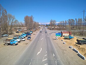
and is inaccessible from Georgian controlled territory with a roadblock north of Ergneti village
369:
runs. Crossing into South Ossetia from Georgian controlled territory (and vice versa) is not possible.
664:. In winter the upper parts of the highway are frequently closed for short periods due to heavy snow.
1357:
1352:
1347:
1342:
1337:
1332:
1327:
1322:
1317:
755:
737:
626:
is located directly north from the boundary line. In South Ossetia the S10 highway is referred to as
560:
523:
river or its upper tributaries into the highest regions of the road. The route enters Russia via the
405:. Prior to the 1980s the route of today's S10 was unnumbered as was the case with most Soviet roads.
339:
123:
422:
306:
1158:
1115:
656:
445:
Before the tunnel through the Roki Pass opened in November 1984, there was no direct road from the
426:
310:
51:
761:
743:
573:
500:
136:
603:
592:
543:
535:
1292:
933:
709:
409:
285:
226:
222:
212:
611:
896:
850:
945:
813:
584:
1184:
1401:
1005:
979:
925:
882:
835:
677:
649:
632:
619:
568:
556:
552:
520:
512:
504:
492:
414:
366:
298:
236:
107:
66:
572:
Ergneti village a roadblock at the boundary line prevents further travel. Since the
673:
462:
386:
1052:
661:
524:
476:
430:
390:
354:
323:
314:
182:
1180:
623:
516:
418:
358:
302:
240:
70:
721:
902:
150:
655:
The Transkam Highway continues alongside the Liakhvi River, passes through
389:, while the Java-Roki segment of today's S10 was designated R-24 when the
788:
784:
731:
727:
564:
131:
127:
1084:
1067:
951:
778:
641:
597:
402:
382:
331:
189:
168:
880:
350:. It is not part of European or Asian international highway routes.
377:
The current S10 route was divided over different routes within the
1161:(in Georgian). The Legislative Herald of Georgia. 16 December 1996
610:
602:
591:
583:
542:
534:
495:
at an elevation of 600 m (2,000 ft) asl and goes to the
24:
1308:
1116:"2014 List of highways of international and domestic importance"
1258:
1118:(in Georgian). The Legislative Herald of Georgia. 18 June 2014
766:
748:
141:
1091:
1.000 mi = 1.609 km; 1.000 km = 0.621 mi
342:
just outside of the city of Gori, is often referred to as
1239:(in Russian). Newspaper Respublika SO. 5 November 2019
507:
and is not under central Georgian control. Until the
401:, which was finished in 1986, continued as R-297 to
296:, road of international importance), also known as "
1301:
250:
232:
218:
206:
174:
113:
103:
98:
90:
82:
77:
21:
676:region. Most of the route is located in breakaway
1214:] (in Russian). Ordzhonikidze (Vladikavkaz):
563:. This highway provides a motorway connection to
519:the route enters the mountains and follows the
1183:[Transcaucasus Highway] (in Russian).
34:
1270:
8:
338:. The S10 route, which intersects with the
1277:
1263:
1255:
1110:
1108:
682:
472:Council of Ministers of the Soviet Union
1104:
1206:Gusalov, N.A.; Kortiev, L. I. (1987).
491:The S10 highway begins in the city of
18:
1065:
1059:
1051:
1045:
1040:
1034:
1029:
1023:
1018:
1012:
1003:
997:
992:
986:
977:
971:
966:
955:
937:
923:
917:
906:
888:
870:
864:
858:
842:
833:
827:
821:
805:
800:
794:
735:
713:
622:administrative capital and only city
7:
294:Saertashoriso mnishvnelobis gza S10
644:, a former lead-zinc mining town.
437:)" replaced the old designations.
14:
1138:"Road numbering systems - Russia"
1386:
1307:
1291:
1075:
1066:
956:
944:
907:
895:
871:
849:
812:
777:
765:
760:
754:
747:
742:
736:
720:
547:De facto terminus S10 at Ergneti
447:South Ossetian Autonomous Oblast
288:: საერთაშორისო მნიშვნელობის გზა
194:
188:
160:
149:
140:
135:
122:
86:92.5 km (57.5 mi)
59:
50:
23:
44:Gori-Tskhinvali-Gupta-Java-Roki
1208:Транскавказская автомагистраль
876:Ergneti roadblock. No passage.
1:
451:North Ossetian Autonomous SSR
1304:International S-highways (ს)
1181:"Транскавказская магистраль"
555:the S10 runs north from the
539:S10 through Karaleti village
483:was fully finished in 1986.
397:side of the Roki Tunnel the
363:Administrative Boundary Line
993:Crosses Gudisistskali River
967:Crosses Patsa River (200 m)
1424:
1408:Roads in Georgia (country)
932:
607:Final climb to Roki Tunnel
551:Starting in the centre of
479:opened in 1984, while the
1384:
1090:
1062:
1048:
1037:
1026:
1015:
1000:
989:
974:
962:
950:
943:
940:
920:
913:
901:
894:
891:
867:
860:
855:
848:
845:
830:
823:
818:
811:
808:
797:
772:
726:
719:
716:
708:
703:
700:
697:
694:
691:
688:
685:
255:
246:
211:
202:
58:
49:
42:
35:
33:
1030:Crosses Somikhdoni River
615:South portal Roki Tunnel
559:out of town towards the
801:Crosses Charebula River
672:The entire route is in
393:opened in 1984. On the
336:R217 "Caucasus Highway"
616:
608:
600:
589:
548:
540:
467:Georgian Military Road
459:Ossetian Military Road
348:Transcaucasian Highway
1216:Ir (publishing house)
1212:Transcaucasus Highway
614:
606:
595:
588:1929 Guftinsky Bridge
587:
546:
538:
16:Trunk road in Georgia
1074:. Road continues as
266:International Routes
1287:Highways in Georgia
379:Soviet road network
115:Major intersections
628:"Transkam Highway"
617:
609:
601:
590:
549:
541:
501:Caucasus Mountains
1395:
1394:
1096:
1095:
580:Tskhinvali - Roki
278:
277:
156:South Ossetia ABL
78:Route information
1415:
1390:
1311:
1305:
1296:
1295:
1288:
1279:
1272:
1265:
1256:
1249:
1248:
1246:
1244:
1233:
1227:
1226:
1224:
1203:
1197:
1196:
1194:
1192:
1187:. 28 August 2016
1177:
1171:
1170:
1168:
1166:
1155:
1149:
1148:
1146:
1144:
1134:
1128:
1127:
1125:
1123:
1112:
1079:
1070:
960:
948:
911:
899:
881:De facto border
875:
853:
816:
782:
781:
769:
764:
758:
751:
746:
740:
724:
683:
481:Transkam Highway
399:Transkam Highway
259:Roads in Georgia
198:
193:
192:
164:
153:
144:
139:
126:
116:
63:
54:
38:
37:
27:
19:
1423:
1422:
1418:
1417:
1416:
1414:
1413:
1412:
1398:
1397:
1396:
1391:
1382:
1303:
1297:
1290:
1286:
1283:
1253:
1252:
1242:
1240:
1235:
1234:
1230:
1218:
1205:
1204:
1200:
1190:
1188:
1179:
1178:
1174:
1164:
1162:
1157:
1156:
1152:
1142:
1140:
1136:
1135:
1131:
1121:
1119:
1114:
1113:
1106:
1101:
1092:
1081:Russian highway
834:Crosses Little
776:
774:
753:
730:
670:
620:South Ossetia's
582:
533:
489:
443:
375:
271:National Routes
187:
186:
114:
99:Major junctions
73:
36:საერთაშორისო 10
28:
17:
12:
11:
5:
1421:
1419:
1411:
1410:
1400:
1399:
1393:
1392:
1385:
1383:
1381:
1380:
1375:
1370:
1365:
1360:
1355:
1350:
1345:
1340:
1335:
1330:
1325:
1320:
1314:
1312:
1299:
1298:
1284:
1282:
1281:
1274:
1267:
1259:
1251:
1250:
1228:
1198:
1185:Caucasian Knot
1172:
1150:
1129:
1103:
1102:
1100:
1097:
1094:
1093:
1088:
1087:
1072:Russian border
1064:
1061:
1057:
1056:
1050:
1047:
1043:
1042:
1041:Tunnel (360 m)
1039:
1036:
1032:
1031:
1028:
1025:
1021:
1020:
1019:Tunnel (130 m)
1017:
1014:
1010:
1009:
1002:
999:
995:
994:
991:
988:
984:
983:
976:
973:
969:
968:
964:
963:
961:
954:
949:
942:
939:
936:
930:
929:
922:
919:
915:
914:
912:
905:
900:
893:
890:
886:
885:
878:
877:
869:
866:
862:
861:
859:
857:
854:
847:
844:
840:
839:
832:
829:
825:
824:
822:
820:
817:
810:
807:
803:
802:
799:
796:
792:
791:
771:
734:
725:
718:
715:
712:
706:
705:
702:
699:
696:
693:
690:
687:
669:
666:
581:
578:
532:
531:Gori - Ergneti
529:
497:Russian border
488:
485:
442:
439:
435:Russian border
374:
371:
320:Russian border
276:
275:
274:
273:
268:
262:
261:
253:
252:
251:Highway system
248:
247:
244:
243:
234:
230:
229:
220:
219:Municipalities
216:
215:
209:
208:
204:
203:
200:
199:
179:Russian border
176:
175:North end
172:
171:
117:
111:
110:
105:
104:South end
101:
100:
96:
95:
92:
88:
87:
84:
80:
79:
75:
74:
64:
56:
55:
47:
46:
40:
39:
31:
30:
22:
15:
13:
10:
9:
6:
4:
3:
2:
1420:
1409:
1406:
1405:
1403:
1389:
1379:
1376:
1374:
1371:
1369:
1366:
1364:
1361:
1359:
1356:
1354:
1351:
1349:
1346:
1344:
1341:
1339:
1336:
1334:
1331:
1329:
1326:
1324:
1321:
1319:
1316:
1315:
1313:
1310:
1306:
1300:
1294:
1289:
1280:
1275:
1273:
1268:
1266:
1261:
1260:
1257:
1238:
1232:
1229:
1222:
1217:
1213:
1209:
1202:
1199:
1186:
1182:
1176:
1173:
1160:
1154:
1151:
1139:
1133:
1130:
1117:
1111:
1109:
1105:
1098:
1089:
1086:
1082:
1078:
1073:
1069:
1058:
1054:
1044:
1033:
1022:
1011:
1007:
996:
985:
981:
970:
965:
959:
953:
947:
935:
931:
927:
916:
910:
904:
898:
887:
884:
883:South Ossetia
879:
874:
863:
852:
841:
837:
826:
815:
804:
793:
790:
786:
780:
768:
763:
757:
750:
745:
739:
733:
729:
723:
711:
707:
684:
681:
679:
678:South Ossetia
675:
668:Intersections
667:
665:
663:
658:
653:
651:
650:Transcaucasia
645:
643:
639:
634:
629:
625:
621:
613:
605:
599:
594:
586:
579:
577:
575:
570:
566:
562:
558:
557:Gori Fortress
554:
545:
537:
530:
528:
526:
522:
518:
514:
513:South Ossetia
510:
509:boundary line
506:
505:South Ossetia
502:
498:
494:
486:
484:
482:
478:
473:
468:
464:
460:
456:
452:
448:
440:
438:
436:
432:
428:
424:
420:
416:
411:
406:
404:
400:
396:
392:
388:
384:
380:
372:
370:
368:
367:South Ossetia
365:of breakaway
364:
360:
356:
351:
349:
345:
341:
337:
333:
329:
325:
321:
317:
316:
312:
308:
304:
300:
295:
291:
287:
283:
280:The Georgian
272:
269:
267:
264:
263:
260:
257:
256:
254:
249:
245:
242:
238:
235:
231:
228:
224:
221:
217:
214:
210:
205:
201:
197:
191:
184:
180:
177:
173:
170:
167:
163:
158:
157:
152:
146:
143:
138:
133:
129:
125:
118:
112:
109:
106:
102:
97:
93:
89:
85:
81:
76:
72:
68:
62:
57:
53:
48:
45:
41:
32:
26:
20:
1362:
1241:. Retrieved
1231:
1211:
1207:
1201:
1191:13 September
1189:. Retrieved
1175:
1163:. Retrieved
1153:
1141:. Retrieved
1132:
1120:. Retrieved
698:Destinations
686:Municipality
674:Shida Kartli
671:
654:
646:
618:
596:Junction to
550:
490:
463:Mamison Pass
455:Russian SFSR
444:
407:
395:Russian SFSR
376:
352:
328:A164 highway
297:
293:
289:
281:
279:
258:
233:Major cities
147:
120:
94:1996–present
43:
1219: [
1053:Roki Tunnel
775:Highway to
662:Roki Tunnel
525:Roki Tunnel
477:Roki tunnel
441:Roki Tunnel
391:Roki Tunnel
355:Roki Tunnel
324:Roki Tunnel
1099:References
631:along the
624:Tskhinvali
561:S1 highway
517:Tskhinvali
419:Tskhinvali
373:Background
361:where the
359:Tskhinvali
340:S1 highway
303:Tskhinvali
241:Tskhinvali
154:Roadblock
71:Tskhinvali
1243:25 August
1143:22 August
1122:22 August
903:Akhalgori
121: 4
65:S10 from
1402:Category
1055:(3730 m)
1004:Crosses
978:Crosses
924:Crosses
640:road to
574:2008 war
461:via the
344:Transkam
334:and the
286:Georgian
207:Location
1165:22 July
1006:Liakhvi
980:Liakhvi
926:Liakhvi
836:Liakhvi
819:Dzevera
789:Sokhumi
785:Zugdidi
732:Sokhumi
728:Tbilisi
633:Liakhvi
569:Liakhvi
565:Tbilisi
521:Liakhvi
499:in the
453:in the
449:to the
410:Georgia
284:route (
213:Georgia
132:Tbilisi
128:Sokhumi
91:Existed
1085:Alagir
952:Kvaisi
773:
695:
642:Kvaisi
598:Kvaisi
408:After
403:Alagir
385:until
383:Kvaisa
332:Alagir
169:Kvaisa
83:Length
1223:]
1210:[
1008:River
982:River
928:River
856:Ditsi
838:River
704:Notes
701:Route
487:Route
423:Gupta
307:Gupta
119:(km)
1245:2021
1193:2021
1167:2021
1145:2021
1124:2021
934:Java
787:and
783:via
710:Gori
657:Java
638:Sh25
553:Gori
493:Gori
431:Roki
427:Java
415:Gori
315:Roki
311:Java
299:Gori
237:Gori
227:Java
223:Gori
183:Roki
166:Sh25
108:Gori
67:Gori
1378:S13
1373:S12
1368:S11
1363:S10
1083:to
809:8.7
798:6.2
717:2.5
511:of
387:Oni
346:or
330:to
290:ს10
282:S10
159:49
148:30
69:to
29:S10
1404::
1358:S9
1353:S8
1348:S7
1343:S6
1338:S5
1333:S4
1328:S3
1323:S2
1318:S1
1221:ru
1107:^
1063:57
1060:92
1049:56
1046:90
1038:55
1035:89
1027:48
1024:78
1016:48
1013:77
1001:39
998:62
990:36
987:58
975:35
972:56
941:30
938:49
921:21
918:33
892:20
889:32
868:19
865:30
846:15
843:24
831:14
828:23
806:14
795:10
692:mi
689:km
527:.
292:,
239:,
225:,
145:)
130:/
1278:e
1271:t
1264:v
1247:.
1225:.
1195:.
1169:.
1147:.
1126:.
770:)
759:(
752:)
741:(
714:4
433:(
429:-
425:-
421:-
417:-
318:(
313:-
309:-
305:-
301:-
185:)
181:(
134:(
Text is available under the Creative Commons Attribution-ShareAlike License. Additional terms may apply.