303:
264:
206:
47:
395:
54:
381:
31:
365:, facing St. Thomas' Bay. It has a number of terraced fields, and commands good views of the bay from its heights. The fields are typical Maltese agricultural land, consisting of small plots. The soil depth is less than two feet on average, containing mainly silty-sandy soil. The plots are terraced on levels with rubble walls. As Munxar lacks water supply, the site is only viable to be cultivated by winter crops like
224:. The exact location of the chapel cannot be ascertained, however, its location is linked to a shrine to St Thomas on the main road to Żejtun. Historically, the bay formed part of the nearby town of Żejtun, which lies immediately uphill of the inlet. The bay and Munxar point are popular with residents of Żejtun and other inland villages for swimming, hunting and bird-trapping.
276:
402:
In 1995, the land was proposed for development into a tourist village, but the plans were successfully resisted by residents and activists of the surrounding villages, and were shelved in 1996. More recent applications were filed for an agri-tourism village and for solar farms. These were either
251:
The town of
Marsascala developed on the northern shores of the bay, while the headland of Il-Munxar forms the southern edge of the bay. The bay contains a number of smaller inlets, some with sand, while the bay also serves as a harbour for a number of small boats. In its inner creek, there are a
302:
46:
231:
following his shipwreck on Malta. This theory is based on both geography, as well as archaeological findings of ancient Roman anchors in the bay. St Thomas' Bay includes a number of fortifications, including the Grade 1 scheduled
705:
369:. Part of the promontory forms part of a designated national park, and the headland is a scheduled Area of High Landscape Value. Munxar headland is close to the recorded megalithic remains at
583:
551:
767:
263:
613:
697:
668:
205:
575:
449:
374:
543:
494:
759:
89:
643:
734:
605:
527:
660:
308:
Euroclydon: or the dangers of the sea considered and improved, in some reflections upon St. Paul's voyage and shipwreck.
370:
388:
810:
275:
394:
805:
441:
486:
815:
362:
237:
221:
124:
820:
380:
639:
523:
334:
245:
233:
168:
342:
337:
from Munxar point. The old
Italian placename for the stacks jutting out of the headland was
314:
292:
284:
228:
181:
326:
726:
799:
790:
30:
325:
on the southern edge of the bay. The headland takes its name from a number of
197:
104:
91:
322:
306:
Four sea stacks can be seen in this 1767 map by John
Brekell, in his book
470:
Abela, Joe (June 2007). "Il-Knisja il-Qadima ta' San Tumas fir-Ramla".
227:
Some historians contend that St Thomas' Bay marks the true landfall of
420:
385:
366:
661:"St Thomas Bay boathouses: Court order sparked need for action plan"
398:
Munxar headland today. St Thomas' Bay can be seen in the background.
220:
The bay takes its name from an ancient medieval chapel dedicated to
698:"80,000 square metre agri-tourism village proposed off Marsaskala"
393:
301:
274:
271:
is used to describe the stacks and reefs at the tip of Munxar Bay.
262:
204:
193:
75:
330:
760:"'Solar greenhouse' plans go dark as applicant pulls the plug"
354:
288:
189:
522:. Amsterdam: Amsterdam University Press. pp. 243–247.
576:"Could St Paul Have been shipwrecked in St Thomas Bay?"
209:
St Thomas' Bay, with Munxar headland in the background.
544:"St Paul's Shipwreck: St Paul's Bay or St Thomas Bay?"
373:, and includes a number of fortifications, including
246:
Ottoman fleet anchored in the bay and raided Żejtun
158:
150:
142:
134:
130:
120:
81:
71:
18:
606:"300-year-old fortification is falling to pieces"
279:In this 1748 map, the group of stacks are called
82:
403:deemed incompatible with the area or withdrawn.
196:, located in the limits of the seaside town of
419:Munxar headland should not be confused with a
349:In other maps, the group of stacks is called
8:
361:.' The headland is an unspoiled part of the
53:
15:
384:An abandoned gun battery used during the
518:Boissevain, Jeremy; Selwyn, Tom (2004).
379:
35:The bay as seen from the Munxar Headland
791:VisitMalta.com - Malta Beaches and Bays
433:
236:at its southern end. A large fortress,
753:
751:
691:
689:
687:
685:
442:"Fine Arts: St Thomas Panel Painting"
7:
727:"Geology and Topography of the Park"
638:. Bradt Travel Guides. p. 184.
570:
568:
513:
511:
758:Leone Ganado, Philip (2018-07-30).
604:Leone Ganado, Philip (2017-01-16).
14:
154:0.29 square kilometres (72 acres)
485:Debono, Carmelina (2006-05-25).
357:.' The Maltese word for saw is '
333:, which used to extend into the
52:
45:
29:
770:from the original on 2019-07-16
737:from the original on 2019-06-23
708:from the original on 2019-07-16
671:from the original on 2019-07-16
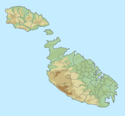
616:from the original on 2019-07-16
586:from the original on 2019-07-16
554:from the original on 2018-09-26
497:from the original on 2019-07-16
452:from the original on 2019-07-16
162:2.17 kilometres (7,100 ft)
157:
149:
146:0.44 kilometres (1,400 ft)
141:
138:0.54 kilometres (1,800 ft)
133:
1:
696:Vella, Matthew (2016-01-18).
70:
375:St. Paul's tower and chapel
267:In this 1681 map, the name
837:
731:Xrobb l-Għaġin Nature Park
659:Ameen, Juan (2011-07-12).
242:Il-Gżira ta' Wied il-Għajn
169:not a well-defined measure
487:"Neglected St Thomas Bay"
329:, long since eroded into
166:
40:
28:
23:
520:Contesting the foreshore
240:was built at the tip of
125:Saint Thomas the Apostle
399:
391:
310:
299:
272:
252:number of boathouses.
210:
186:Id-daħla ta' San Tumas
185:
24:Il-Bajja ta' San Tumas
580:The Malta Independent
548:The Malta Independent
397:
383:
305:
278:
266:
222:St Thomas the Apostle
208:
105:35.85250°N 14.56583°E
634:Rix, Juliet (2019).
389:occupation of malta.
423:with the same name.
101: /
400:
392:
363:Delimara peninsula
321:) is a rock-bound
311:
300:
291:, a tool which in
273:
211:
110:35.85250; 14.56583
448:. 16 April 2012.
335:Mediterranean sea
313:Munxar headland (
244:in 1614 after an
175:
174:
828:
811:Beaches of Malta
779:
778:
776:
775:
755:
746:
745:
743:
742:
723:
717:
716:
714:
713:
693:
680:
679:
677:
676:
656:
650:
649:
631:
625:
624:
622:
621:
601:
595:
594:
592:
591:
572:
563:
562:
560:
559:
540:
534:
533:
515:
506:
505:
503:
502:
482:
476:
475:
467:
461:
460:
458:
457:
438:
417:
353:, that is, 'the
229:Paul the Apostle
192:in southeastern
167:Shore length is
116:
115:
113:
112:
111:
106:
102:
99:
98:
97:
94:
84:
56:
55:
49:
33:
16:
836:
835:
831:
830:
829:
827:
826:
825:
796:
795:
787:
782:
773:
771:
757:
756:
749:
740:
738:
725:
724:
720:
711:
709:
695:
694:
683:
674:
672:
658:
657:
653:
646:
633:
632:
628:
619:
617:
603:
602:
598:
589:
587:
574:
573:
566:
557:
555:
542:
541:
537:
530:
517:
516:
509:
500:
498:
484:
483:
479:
469:
468:
464:
455:
453:
440:
439:
435:
431:
421:village in Gozo
414:
410:
404:
331:submerged reefs
261:
238:St Thomas tower
218:
213:
212:
109:
107:
103:
100:
95:
92:
90:
88:
87:
67:
66:
65:
64:
63:
62:
61:
57:
36:
12:
11:
5:
834:
832:
824:
823:
818:
813:
808:
798:
797:
794:
793:
786:
785:External links
783:
781:
780:
764:Times of Malta
747:
718:
681:
665:Times of Malta
651:
645:978-1784770709
644:
636:Malta and Gozo
626:
610:Times of Malta
596:
582:. 2010-02-27.
564:
550:. 2010-04-25.
535:
528:
507:
491:Times of Malta
477:
462:
446:Wirt iż-Żejtun
432:
430:
427:
426:
425:
409:
406:
371:Xrobb l-Għaġin
260:
254:
234:Riħama Battery
217:
214:
203:
202:
178:St Thomas' Bay
173:
172:
164:
163:
160:
156:
155:
152:
148:
147:
144:
140:
139:
136:
132:
131:
128:
127:
122:
118:
117:
85:
79:
78:
73:
69:
68:
60:St Thomas' Bay
59:
58:
51:
50:
44:
43:
42:
41:
38:
37:
34:
26:
25:
21:
20:
19:St Thomas' Bay
13:
10:
9:
6:
4:
3:
2:
833:
822:
819:
817:
814:
812:
809:
807:
806:Bays of Malta
804:
803:
801:
792:
789:
788:
784:
769:
765:
761:
754:
752:
748:
736:
732:
728:
722:
719:
707:
703:
699:
692:
690:
688:
686:
682:
670:
666:
662:
655:
652:
647:
641:
637:
630:
627:
615:
611:
607:
600:
597:
585:
581:
577:
571:
569:
565:
553:
549:
545:
539:
536:
531:
525:
521:
514:
512:
508:
496:
492:
488:
481:
478:
473:
466:
463:
451:
447:
443:
437:
434:
428:
424:
422:
416:
412:
411:
407:
405:
396:
390:
387:
382:
378:
376:
372:
368:
364:
360:
356:
352:
348:
345:: The Wreath)
344:
340:
336:
332:
328:
324:
320:
319:Ras il-Munxar
316:
309:
304:
298:
294:
290:
286:
282:
277:
270:
265:
258:
255:
253:
249:
247:
243:
239:
235:
230:
225:
223:
215:
207:
201:
199:
195:
191:
187:
183:
179:
170:
165:
161:
153:
145:
137:
129:
126:
123:
119:
114:
86:
80:
77:
74:
48:
39:
32:
27:
22:
17:
772:. Retrieved
763:
739:. Retrieved
730:
721:
710:. Retrieved
701:
673:. Retrieved
664:
654:
635:
629:
618:. Retrieved
609:
599:
588:. Retrieved
579:
556:. Retrieved
547:
538:
519:
499:. Retrieved
490:
480:
471:
465:
454:. Retrieved
445:
436:
418:
415:
401:
358:
350:
346:
338:
318:
312:
307:
296:
280:
268:
256:
250:
241:
226:
219:
177:
176:
159:Shore length
151:Surface area
702:Malta Today
287:word for a
135:Max. length
108: /
83:Coordinates
816:Marsaskala
800:Categories
774:2019-07-16
741:2019-07-16
712:2019-07-16
675:2019-07-16
620:2019-07-16
590:2019-07-16
558:2019-07-16
529:9053566945
501:2019-07-16
456:2019-07-16
429:References
295:is called
198:Marsascala
143:Max. width
96:14°33′57″E
93:35°51′09″N
472:Iż-Żejtun
323:peninsula
121:Etymology
768:Archived
735:Archived
706:Archived
669:Archived
614:Archived
584:Archived
552:Archived
495:Archived
450:Archived
351:La Serra
339:La Serta
281:La Serra
269:La Serta
259:headland
72:Location
343:English
315:Maltese
297:munxar.
293:Maltese
285:Italian
188:) is a
182:Maltese
821:Żejtun
642:
526:
386:french
367:fodder
359:Munxar
327:stacks
283:, the
257:Munxar
408:Notes
216:About
194:Malta
76:Malta
640:ISBN
524:ISBN
355:saw
289:saw
200:.
190:bay
802::
766:.
762:.
750:^
733:.
729:.
704:.
700:.
684:^
667:.
663:.
612:.
608:.
578:.
567:^
546:.
510:^
493:.
489:.
444:.
377:.
317::
248:.
184::
777:.
744:.
715:.
678:.
648:.
623:.
593:.
561:.
532:.
504:.
474:.
459:.
413:.
347:.
341:(
180:(
171:.
Text is available under the Creative Commons Attribution-ShareAlike License. Additional terms may apply.