35:
294:
255:
192:
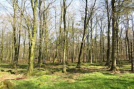
There is a loop walk, starting from the car parking area, of 800m taking in a couple of view points with the paths upgraded early in 2009 to be suitable for disabled access.
123:
335:
167:
106:
17:
364:
328:
117:
354:
209:
359:
321:
34:
182:
70:
60:
82:
293:
305:
186:
136:
131:
171:
87:
75:
348:
175:
91:
270:
257:
234:
301:
163:
156:
110:
159:
50:
152:
309:
130:
116:
102:
97:
81:
69:
59:
49:
44:
27:
329:
8:
336:
322:
24:
201:
7:
290:
288:
308:. You can help Knowledge (XXG) by
18:Staple Hill, South Gloucestershire
14:
181:This is one of the points on the
292:
33:
210:"All High Points Height Order"
1:
16:For the Bristol suburb, see
166:, the highest point in the
381:
287:
170:. It is classed as both a
55:315 m (1,033 ft)
15:
183:Staple Fitzpaine Herepath
32:
365:Somerset geography stubs
215:. The Hardys. p. 65
65:212 m (696 ft)
39:Staple Hill Plantations
304:location article is a
235:"Staple Hill Car Park"
271:50.94381°N 3.08314°W
355:Marilyns of England
267: /
276:50.94381; -3.08314
237:. Forestry England
45:Highest point
360:Hills of Somerset
317:
316:
146:
145:
372:
338:
331:
324:
296:
289:
282:
281:
279:
278:
277:
272:
268:
265:
264:
263:
260:
247:
246:
244:
242:
231:
225:
224:
222:
220:
214:
206:
187:Forestry England
126:
37:
25:
380:
379:
375:
374:
373:
371:
370:
369:
345:
344:
343:
342:
285:
275:
273:
269:
266:
261:
258:
256:
254:
253:
251:
250:
240:
238:
233:
232:
228:
218:
216:
212:
208:
207:
203:
198:
168:Blackdown Hills
122:
107:Blackdown Hills
40:
21:
12:
11:
5:
378:
376:
368:
367:
362:
357:
347:
346:
341:
340:
333:
326:
318:
315:
314:
297:
249:
248:
226:
200:
199:
197:
194:
144:
143:
134:
128:
127:
120:
114:
113:
104:
100:
99:
95:
94:
85:
79:
78:
76:Dunkery Beacon
73:
67:
66:
63:
57:
56:
53:
47:
46:
42:
41:
38:
30:
29:
13:
10:
9:
6:
4:
3:
2:
377:
366:
363:
361:
358:
356:
353:
352:
350:
339:
334:
332:
327:
325:
320:
319:
313:
311:
307:
303:
298:
295:
291:
286:
283:
280:
236:
230:
227:
211:
205:
202:
195:
193:
190:
188:
184:
179:
177:
173:
169:
165:
161:
158:
154:
150:
141:
138:
135:
133:
129:
125:
121:
119:
115:
112:
108:
105:
101:
96:
93:
89:
86:
84:
80:
77:
74:
72:
68:
64:
62:
58:
54:
52:
48:
43:
36:
31:
26:
23:
19:
310:expanding it
299:
284:
252:
239:. Retrieved
229:
217:. Retrieved
204:
191:
180:
148:
147:
139:
22:
274: /
189:woodlands.
149:Staple Hill
71:Parent peak
28:Staple Hill
349:Categories
259:50°56′38″N
196:References
185:a part of
140:Landranger
61:Prominence
262:3°04′59″W
98:Geography
51:Elevation
302:Somerset
164:Somerset
132:Topo map
124:ST240166
103:Location
241:30 June
219:30 June
172:Marilyn
157:English
155:in the
118:OS grid
111:England
88:Marilyn
83:Listing
174:and a
160:county
300:This
213:(PDF)
176:Hardy
151:is a
92:Hardy
306:stub
243:2015
221:2015
153:hill
162:of
142:193
351::
178:.
137:OS
109:,
90:,
337:e
330:t
323:v
312:.
245:.
223:.
20:.
Text is available under the Creative Commons Attribution-ShareAlike License. Additional terms may apply.
