287:
320:
454:
479:
437:
306:. The contract for construction of the lock and dam was originally awarded in 1923 but fell through when the contractor failed to show up for the contract signing. Following a period of time during which land litigation issues were cleared, a second contract was awarded in 1926. The lock and dam was about 95 percent complete when the state of Illinois fell upon financial difficulty and the project was turned over to the federal government for completion. Under the authority of the
34:
486:
461:
364:'s appointee to oversee the Waterway Project. Thus, Mickle designed the facilities at Starved Rock Lock and Dam. Legislation which codified the construction of the Waterway only stipulated the general design and location of the locks and dams along the Illinois River; the details were left to Barnes, Smith and other engineers. Barnes had 20 years' experience as a
934:
350:
of 110 by 600 feet (34 by 183 m). The lock has a drop/lift of about 18 feet (5 m). The chamber of the lock is formed by two parallel gravity section walls 38 feet (12 m) tall on the north and south. These are framed horizontally by two miter gates at the east and west ends of the lock.
579:. Starved Rock was deemed eligible for the listing when the rest of the Illinois Waterway was also determined eligible; the day Starved Rock Lock and Dam was listed the other 7 lock and dam sites on the Waterway were also listed on the National Register of Historic Places.
1000:
975:
338:
of 714 feet (218 m). The dam is 33 feet (10 m) wide at its base, 22 feet 3 inches (6.78 m) wide at the crest of the head gate and 50 feet 6 inches (15.39 m) wide at the crest of the
310:
the federal government oversaw the completion of
Starved Rock Lock and Dam in 1933. Construction of the facility cost US$ 4,462,737; of that amount, $ 3,577,419 was provided by the state and $ 885,318 was federal money.
985:
965:
388:
A hydroelectric power station generates a peak of 7,600 kW of electricity, and is operated by the city of Peru, Illinois. The power plant has experienced two fires since its construction.
970:
294:
The
Starved Rock Lock and Dam was constructed between 1926 and 1933 as an element of the Illinois Waterway. The Waterway was a project designed to provide a navigable channel from the
582:
The district has significance in three areas. According to the
National Register of Historic Places' criteria, those are: engineering, transportation and maritime history. The
995:
990:
590:
to the historic district and two buildings are considered non-contributing members. Starved Rock Lock and Dam
Historic District covers 27.95 acres (113,100 m).
83:
478:
376:
project; they had both resigned in 1907 to go to work for the New York Board of Water Supply. Together the two men also formed a general hydraulic and
828:
797:
643:
708:
453:
286:
423:
916:
717:
142:
885:
856:
837:
806:
652:
572:
414:
938:
904:
907:
583:
575:
as the
Starved Rock Lock and Dam Historic District. It was listed as part of the Illinois Waterway Navigation System Facilities
945:
764:
776:
747:
735:
681:
234:
and was constructed between 1926 and 1933. The lock and dam was added to the
National Register of Historic Places as the
576:
539:
275:
219:
271:
673:
377:
55:
980:
599:
67:
319:
825:
794:
640:
347:
307:
705:
861:
436:
587:
532:
354:
335:
328:
203:
33:
768:
739:
369:
250:, Starved Rock Lock and Dam is the southernmost facility. The lock and dam are located along the
357:
was hired as Chief Design
Engineer for the Illinois Waterway Project by Mortimer Grant Barnes,
772:
743:
677:
358:
303:
247:
231:
334:
1,310 feet (400 m) long. The dam consists of a head gate of 518 feet (158 m) and a
506:
911:
832:
801:
712:
647:
361:
259:
59:
365:
299:
251:
223:
169:
555:
959:
586:
consists of five total buildings and structures. One building and two structures are
71:
368:
and had worked as an assistant to the engineer in charge of the construction of the
373:
263:
227:
343:. The dam's height above the riverbed varies from 21 to 34 feet (6 to 10 m).
331:
295:
159:
880:
761:
Cruising Guide from Lake
Michigan to Kentucky Lake: The Heartland Rivers Route
267:
721:– Mississippi Valley Division, September 2009, p. 71, accessed June 16, 2011.
98:
85:
372:
when Lowden tapped him to head the project. Smith worked with Barnes on the
1001:
Historic districts on the
National Register of Historic Places in Illinois
933:
340:
255:
63:
949:
706:
Upper
Mississippi River – Illinois Waterway System Locks & Dams
571:
On March 10, 2004, the Starved Rock Lock and Dam was listed on the
881:
Weekly List of Actions Taken on Properties: 4/30/07 Through 5/4/07
318:
285:
952:", 24 photos, 46 data pages, 2 photo caption pages
851:
976:
National Register of Historic Places in LaSalle County, Illinois
889:
via National Park Service, May 11, 2007, accessed June 15, 2011.
346:
The lock at Starved Rock Lock and Dam is an Ohio River Standard
154:
986:
Locks on the National Register of Historic Places in Illinois
323:
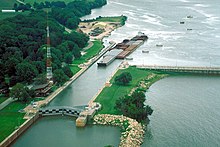
A barge being towed downstream through the Starved Rock lock.
966:
Dams on the National Register of Historic Places in Illinois
327:
Starved Rock Lock and Dam features a straight-crested,
914:", Property Information Report, HAARGIS Database via
561:
548:
538:
528:
520:
512:
502:
199:
191:
183:
175:
165:
153:
148:
138:
130:
122:
114:
77:
51:
43:
26:
544:Illinois Waterway Navigation System Facilities MPS
485:
460:
971:Historic American Engineering Record in Illinois
38:Barges passing through Starved Rock Lock and Dam
676:), Inland Waterways Books, 2009, pp. 64–67, (
8:
274:. The facility is presently operated by the
218:, is a lock and dam facility managed by the
905:Starved Rock Lock and Dam Historic District
441:A close-up of the dam at Lock and Dam No. 6
407:Starved Rock Lock and Dam Historic District
236:Starved Rock Lock and Dam Historic District
996:United States Army Corps of Engineers dams
991:Transport infrastructure completed in 1933
435:
32:
23:
415:U.S. National Register of Historic Places
875:
873:
871:
635:
899:
897:
895:
820:
818:
816:
789:
787:
785:
700:
698:
696:
694:
692:
690:
633:
631:
629:
627:
625:
623:
621:
619:
617:
615:
611:
852:"National Register Information System"
398:
917:Illinois Historic Preservation Agency
718:United States Army Corps of Engineers
664:
662:
143:United States Army Corps of Engineers
7:
946:Historic American Engineering Record
886:National Register of Historic Places
857:National Register of Historic Places
838:Historic American Engineering Record
807:Historic American Engineering Record
653:Historic American Engineering Record
573:National Register of Historic Places
14:
290:Starved Rock Lock and Dam in 1936
932:
484:
477:
459:
452:
21:Dam in Illinois , United States
550:
308:Rivers and Harbors Act of 1930
18:Dam in Illinois, United States
1:
493:Show map of the United States
950:Starved Rock Locks & Dam
577:Multiple Property Submission
396:United States historic place
276:U.S. Army Corps of Engineers
220:U.S. Army Corps of Engineers
670:Illinois Waterway Guidebook
1017:
187:1,310 ft (400 m)
948:(HAER) No. IL-127, "
939:Starved Rock Lock and Dam
920:, accessed June 16, 2011.
826:Starved Rock Lock and Dam
795:Starved Rock Lock and Dam
641:Starved Rock Lock and Dam
549:NRHP reference
516:27.9 acres (11.3 ha)
446:
434:
430:
421:
412:
405:
401:
384:Hydroelectric power plant
212:Starved Rock Lock and Dam
31:
27:Starved Rock Lock and Dam
378:construction engineering
732:Starved Rock State Park
600:Starved Rock State Park
270:231 just upstream from
254:near the north central
123:Construction began
68:Starved Rock State Park
424:U.S. Historic district
324:
291:
195:33 ft (10 m)
179:34 ft (10 m)
941:at Wikimedia Commons
862:National Park Service
322:
289:
155:Type of dam
99:41.32250°N 88.98556°W
588:contributing members
468:Show map of Illinois
230:. It is part of the
730:Barta, Nancy Hill.
533:Walter Mickle Smith
355:Walter Mickle Smith
336:controlled spillway
329:reinforced concrete
246:Along the original
104:41.32250; -88.98556
95: /
910:2009-09-11 at the
831:2012-11-03 at the
800:2012-11-03 at the
769:Pelican Publishing
742:, 2007, pp. 7–8, (
740:Arcadia Publishing
711:2011-07-22 at the
646:2012-11-03 at the
370:Panama Canal locks
325:
292:
216:Lock and Dam No. 6
200:Spillway type
47:Lock and Dam No. 6
937:Media related to
765:Google Books link
736:Google Books link
674:Google Books link
584:historic district
569:
568:
392:Historic district
359:Illinois Governor
348:navigational lock
304:Mississippi River
248:Illinois Waterway
232:Illinois Waterway
209:
208:
192:Width (base)
149:Dam and spillways
131:Opening date
1008:
936:
921:
901:
890:
877:
866:
865:
848:
842:
822:
811:
791:
780:
757:
751:
728:
722:
702:
685:
666:
657:
637:
552:
507:Ottawa, Illinois
494:
488:
487:
481:
469:
463:
462:
456:
439:
399:
214:, also known as
110:
109:
107:
106:
105:
100:
96:
93:
92:
91:
88:
36:
24:
1016:
1015:
1011:
1010:
1009:
1007:
1006:
1005:
956:
955:
930:
925:
924:
912:Wayback Machine
902:
893:
878:
869:
864:. July 9, 2010.
850:
849:
845:
833:Wayback Machine
823:
814:
802:Wayback Machine
792:
783:
771:, 2002 p. 92, (
758:
754:
729:
725:
713:Wayback Machine
703:
688:
667:
660:
648:Wayback Machine
638:
613:
608:
596:
498:
497:
496:
495:
492:
491:
490:
489:
472:
471:
470:
467:
466:
465:
464:
442:
426:
417:
408:
397:
394:
386:
362:Frank O. Lowden
317:
284:
244:
103:
101:
97:
94:
89:
86:
84:
82:
81:
39:
22:
19:
12:
11:
5:
1014:
1012:
1004:
1003:
998:
993:
988:
983:
981:Illinois River
978:
973:
968:
958:
957:
954:
953:
929:
928:External links
926:
923:
922:
891:
867:
843:
812:
781:
759:Rhodes, Rick.
752:
723:
686:
668:Hay, Jerry M.
658:
610:
609:
607:
604:
603:
602:
595:
592:
567:
566:
565:March 10, 2004
563:
559:
558:
553:
546:
545:
542:
536:
535:
530:
526:
525:
522:
518:
517:
514:
510:
509:
504:
500:
499:
483:
482:
476:
475:
474:
473:
458:
457:
451:
450:
449:
448:
447:
444:
443:
440:
432:
431:
428:
427:
422:
419:
418:
413:
410:
409:
406:
403:
402:
395:
393:
390:
385:
382:
366:civil engineer
316:
313:
300:Gulf of Mexico
283:
280:
252:Illinois River
243:
240:
224:Illinois River
207:
206:
201:
197:
196:
193:
189:
188:
185:
181:
180:
177:
173:
172:
170:Illinois River
167:
163:
162:
157:
151:
150:
146:
145:
140:
136:
135:
132:
128:
127:
124:
120:
119:
116:
112:
111:
79:
75:
74:
56:LaSalle County
53:
49:
48:
45:
41:
40:
37:
29:
28:
20:
17:
13:
10:
9:
6:
4:
3:
2:
1013:
1002:
999:
997:
994:
992:
989:
987:
984:
982:
979:
977:
974:
972:
969:
967:
964:
963:
961:
951:
947:
944:
943:
942:
940:
935:
927:
919:
918:
913:
909:
906:
900:
898:
896:
892:
888:
887:
882:
876:
874:
872:
868:
863:
859:
858:
853:
847:
844:
840:
839:
834:
830:
827:
821:
819:
817:
813:
809:
808:
803:
799:
796:
790:
788:
786:
782:
778:
774:
770:
766:
762:
756:
753:
749:
745:
741:
737:
733:
727:
724:
720:
719:
714:
710:
707:
701:
699:
697:
695:
693:
691:
687:
683:
679:
675:
671:
665:
663:
659:
655:
654:
649:
645:
642:
636:
634:
632:
630:
628:
626:
624:
622:
620:
618:
616:
612:
605:
601:
598:
597:
593:
591:
589:
585:
580:
578:
574:
564:
562:Added to NRHP
560:
557:
554:
547:
543:
541:
537:
534:
531:
527:
523:
519:
515:
511:
508:
505:
501:
480:
455:
445:
438:
433:
429:
425:
420:
416:
411:
404:
400:
391:
389:
383:
381:
379:
375:
371:
367:
363:
360:
356:
352:
349:
344:
342:
337:
333:
330:
321:
314:
312:
309:
305:
301:
297:
288:
281:
279:
277:
273:
269:
265:
261:
257:
253:
249:
241:
239:
237:
233:
229:
225:
221:
217:
213:
205:
202:
198:
194:
190:
186:
182:
178:
174:
171:
168:
164:
161:
158:
156:
152:
147:
144:
141:
137:
133:
129:
125:
121:
117:
113:
108:
80:
76:
73:
72:United States
69:
65:
61:
57:
54:
50:
46:
44:Official name
42:
35:
30:
25:
16:
931:
915:
884:
855:
846:
836:
805:
760:
755:
731:
726:
716:
669:
651:
581:
570:
503:Nearest city
387:
374:Panama Canal
353:
345:
326:
293:
264:lock and dam
245:
235:
228:Starved Rock
215:
211:
210:
15:
841:, p. 20-21.
810:, pp. 20–27
332:gravity dam
296:Great Lakes
272:Plum Island
258:village of
160:Gravity dam
139:Operator(s)
118:Operational
102: /
78:Coordinates
960:Categories
777:1565549953
748:0738551368
682:1607438569
268:river mile
222:along the
204:Controlled
87:41°19′21″N
656:, p. 2-3.
529:Architect
238:in 2004.
90:88°59′8″W
908:Archived
829:Archived
798:Archived
709:Archived
644:Archived
594:See also
556:04000166
341:spillway
302:via the
256:Illinois
242:Location
166:Impounds
64:Illinois
52:Location
298:to the
282:History
226:, near
775:
746:
680:
380:firm.
315:Design
266:is at
262:. The
184:Length
176:Height
115:Status
606:Notes
521:Built
260:Utica
60:Utica
773:ISBN
744:ISBN
678:ISBN
524:1933
513:Area
134:1933
126:1926
883:",
835:",
804:",
767:),
763:, (
738:),
734:, (
715:",
672:, (
650:",
551:No.
540:MPS
70:),
962::
894:^
870:^
860:.
854:.
815:^
784:^
779:).
750:).
689:^
684:).
661:^
614:^
278:.
62:,
903:"
879:"
824:"
793:"
704:"
639:"
66:(
58:/
Text is available under the Creative Commons Attribution-ShareAlike License. Additional terms may apply.