1545:
40:
1105:
58:
421:
1408:
1429:
1400:
1383:
1081:
In the town, the population was spread out, with 26.6% under the age of 18, 5.8% from 18 to 24, 28.5% from 25 to 44, 26.2% from 45 to 64, and 13.0% who were 65 years of age or older. The median age was 40 years. For every 100 females, there were 99.2 males. For every 100 females age 18 and over,
1077:
living together, 6.7% had a female householder with no husband present, and 24.2% were non-families. 17.5% of all households were made up of individuals, and 7.7% had someone living alone who was 65 years of age or older. The average household size was 2.65 and the average family size was 2.99.
489:, the town has a total area of 59.7 square miles (154.7 km), of which 58.8 square miles (152.3 km) are land and 0.93 square miles (2.4 km) are water, comprising 1.53% of the town. The town includes the eastern edge of the
1038:
Note: the US Census treats
Hispanic/Latino as an ethnic category. This table excludes Latinos from the racial categories and assigns them to a separate category. Hispanics/Latinos can be of any race.
475:
1085:
The median income for a household in the town was $ 37,946, and the median income for a family was $ 40,089. Males had a median income of $ 35,833 versus $ 24,750 for females. The
1483:
1672:
1777:
1050:
was 8.7 people per square mile (3.4/km). There were 384 housing units at an average density of 6.5 per square mile (2.5/km). The racial makeup of the town was 97.48%
1926:
1921:
1342:
977:
1217:
39:
1873:
78:
1737:
1476:
917:
409:
314:
463:
POW camp located in New
Hampshire. Most of the men in the camp performed hard labor in the nearby forests, supplying wood for the paper mills in
432:
1697:
1692:
931:
144:
1762:
1767:
1742:
1727:
1717:
1469:
324:
1335:
1782:
132:
1757:
1682:
1129:
1820:
1931:
1825:
1722:
1156:
494:
1461:
1863:
1815:
1800:
398:
1702:
1677:
1858:
1707:
1619:
1493:
1392:
1328:
1005:
903:
544:
502:
358:
137:
63:
57:
1891:
1878:
1848:
1805:
1644:
1268:
1059:
490:
486:
452:
1569:
963:
282:
261:
1747:
1654:
858:
843:
828:
813:
798:
783:
768:
753:
738:
723:
708:
693:
678:
663:
648:
633:
618:
603:
588:
366:
1687:
1649:
1634:
1624:
1609:
1604:
1574:
1515:
1438:
1362:
550:
538:
302:
110:
1843:
1810:
1792:
1732:
1712:
1629:
1579:
1443:
1073:
There were 194 households, out of which 33.0% had children under the age of 18 living with them, 61.3% were
532:
386:
378:
1853:
1772:
1564:
1063:
390:
374:
1599:
1589:
1584:
1534:
1414:
1372:
991:
520:
464:
405:
394:
373:. The town includes the villages of Percy and Crystal as well as the village of Stark, located on the
1898:
1868:
1752:
1614:
1594:
1526:
1448:
1418:
1367:
1110:
1067:
526:
514:
271:
48:
1835:
1055:
1051:
1315:
1047:
172:
44:
1242:
1086:
501:. The highest point in Stark is 3,730-foot (1,140 m) Mount Hutchins, on the border with
1089:
for the town was $ 17,168. About 2.5% of families and 5.1% of the population were below the
1556:
1046:
of 2000, there were 516 people, 194 households, and 147 families residing in the town. The
440:
354:
1320:
949:
1664:
370:
1915:
935:
362:
307:
125:
67:
1090:
460:
382:
420:
1157:"Stark town, Coos County, New Hampshire: 2020 DEC Redistricting Data (PL 94-171)"
1508:
455:
camp in the town were converted to form Camp Stark, which held about 250 German
435:. The town was incorporated in 1795, and renamed "Stark" in 1832, after General
1100:
436:
425:
120:
93:
80:
498:
252:
1093:, including none of those under age 18 and 6.2% of those age 65 or over.
1074:
290:
1191:
467:. Some of the men eventually came back to live in the United States and
369:, a decline from the figure of 556 tabulated in 2010. It has a famous
1544:
1043:
468:
497:, including several peaks higher than 3,000 feet (910 m) above
1316:
New
Hampshire Economic and Labor Market Information Bureau Profile
419:
278:
257:
1465:
1324:
1294:
Stark
Decency: German Prisoners of War in a New England Village
456:
476:
List of New
Hampshire historical markers (126–150) § 150
1543:
431:
Granted in 1774, Stark was originally named "Percy", after
439:, who wrote the words that became New Hampshire's motto, "
1308:
1264:
1178:
471:
after the war ended, and the camp was closed in 1946.
339:
1124:
1122:
397:. Much of the town is within the boundaries of the
1834:
1791:
1663:
1555:
1525:
334:
323:
313:
301:
289:
268:
251:
243:
235:
230:
222:
214:
206:
198:
193:
170:
165:
153:
143:
131:
119:
109:
23:
1181:, 2010 Census figures. Retrieved March 23, 2011.
365:, United States. The population was 478 at the
1231:– via newhampshirelakesandmountains.com.
1548:Map of New Hampshire highlighting Coos County
1477:
1336:
1151:
1149:
1147:
218:0.9 sq mi (2.4 km) 1.53%
8:
1130:"2021 U.S. Gazetteer Files – New Hampshire"
1484:
1470:
1462:
1343:
1329:
1321:
1070:of any race were 0.39% of the population.
561:
20:
1296:. University Press of New England, 1988.
878:
1927:Berlin, New Hampshire micropolitan area
1351:Places adjacent to Stark, New Hampshire
1118:
451:In early 1944, the remains of a former
333:
312:
288:
250:
229:
221:
192:
164:
152:
142:
108:
73:
54:
36:
581:
433:Hugh Percy, 1st Duke of Northumberland
1192:"State Emblem, New Hampshire Almanac"
322:
300:
267:
242:
234:
213:
205:
197:
169:
130:
118:
7:
1673:Atkinson and Gilmanton Academy Grant
1358:
1062:, and 0.97% from two or more races.
210:58.8 sq mi (152.3 km)
202:59.7 sq mi (154.7 km)
18:Town in New Hampshire, United States
1922:Towns in Coös County, New Hampshire
410:NH-VT Micropolitan Statistical Area
1492:Municipalities and communities of
1243:"Census of Population and Housing"
571:
14:
1218:"Stark remembers former POW Camp"
1427:
1406:
1398:
1381:
1103:
56:
38:
1778:Thompson and Meserve's Purchase
1216:Burt, Kayti (March 31, 2010).
399:White Mountain National Forest
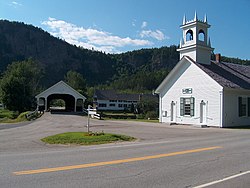
381:runs through Stark, east from
1:
1428:
1382:
1177:United States Census Bureau,
1132:. United States Census Bureau
881:Racial composition as of 2020
1407:
1399:
1269:United States Census Bureau
487:United States Census Bureau
453:Civilian Conservation Corps
1948:
1495:Coös County, New Hampshire
473:
1887:
1541:
1506:
1356:
918:Black or African American
872:
857:
842:
827:
812:
797:
782:
767:
752:
737:
722:
707:
692:
677:
662:
647:
632:
617:
602:
587:
580:
575:
570:
567:
74:
55:
37:
30:
1082:there were 100.5 males.
226:964 ft (294 m)
1738:Low and Burbank's Grant
992:Mixed Race/Multi-Racial
509:Adjacent municipalities
379:New Hampshire Route 110
1932:Towns in New Hampshire
1549:
428:
375:Upper Ammonoosuc River
1547:
1265:"U.S. Census website"
873:U.S. Decennial Census
563:Historical population
465:Berlin, New Hampshire
447:World War II POW camp
423:
404:Stark is part of the
270: • Summer (
247:8/sq mi (3.1/km)
94:44.60139°N 71.40917°W
1900:United States portal
1893:New Hampshire portal
1768:Second College Grant
1222:Coos County Democrat
1159:. U.S. Census Bureau
1111:New Hampshire portal
459:. This was the only
244: • Density
180:Glenn Wiggins, Chair
49:Stark Covered Bridge
25:Stark, New Hampshire
1698:Crawford's Purchase
1693:Chandler's Purchase
1179:American FactFinder
888:
564:
389:and northwest from
99:44.60139; -71.40917
90: /
1783:Wentworth Location
1763:Sargent's Purchase
1550:
1048:population density
1006:Hispanic or Latino
879:
562:
429:
236: • Total
215: • Water
199: • Total
173:Board of Selectmen
45:Stark Union Church
1909:
1908:
1836:Other communities
1821:West Stewartstown
1743:Martin's Location
1728:Hadley's Purchase
1718:Erving's Location
1459:
1458:
1454:
1453:
1087:per capita income
1035:
1034:
892:Race / Ethnicity
885:NH = Non-Hispanic
877:
876:
485:According to the
348:
347:
207: • Land
186:Crystal Pelletier
1939:
1901:
1894:
1546:
1518:
1511:
1501:
1496:
1486:
1479:
1472:
1463:
1431:
1430:
1410:
1409:
1402:
1401:
1385:
1384:
1359:
1345:
1338:
1331:
1322:
1312:
1311:
1309:Official website
1280:
1279:
1277:
1275:
1261:
1255:
1254:
1252:
1250:
1239:
1233:
1232:
1230:
1228:
1213:
1207:
1206:
1204:
1202:
1188:
1182:
1175:
1169:
1168:
1166:
1164:
1153:
1142:
1141:
1139:
1137:
1126:
1113:
1108:
1107:
1106:
964:Pacific Islander
889:
583:
578:
573:
565:
441:Live Free or Die
344:
341:
275:
105:
104:
102:
101:
100:
95:
91:
88:
87:
86:
83:
60:
42:
21:
1947:
1946:
1942:
1941:
1940:
1938:
1937:
1936:
1912:
1911:
1910:
1905:
1899:
1892:
1883:
1864:North Stratford
1830:
1787:
1758:Pinkham's Grant
1683:Bean's Purchase
1659:
1551:
1539:
1521:
1516:
1509:
1502:
1499:
1494:
1490:
1460:
1455:
1417:
1411:
1352:
1349:
1307:
1306:
1303:
1292:Koop, Allen V.
1289:
1287:Further reading
1284:
1283:
1273:
1271:
1263:
1262:
1258:
1248:
1246:
1241:
1240:
1236:
1226:
1224:
1215:
1214:
1210:
1200:
1198:
1190:
1189:
1185:
1176:
1172:
1162:
1160:
1155:
1154:
1145:
1135:
1133:
1128:
1127:
1120:
1109:
1104:
1102:
1099:
1075:married couples
978:Some Other Race
932:Native American
576:
560:
511:
495:White Mountains
483:
478:
449:
418:
338:
297:
269:
189:
160:
158:
98:
96:
92:
89:
84:
81:
79:
77:
76:
70:
51:
33:
26:
19:
12:
11:
5:
1945:
1943:
1935:
1934:
1929:
1924:
1914:
1913:
1907:
1906:
1904:
1903:
1896:
1888:
1885:
1884:
1882:
1881:
1876:
1871:
1866:
1861:
1859:Dixville Notch
1856:
1851:
1846:
1840:
1838:
1832:
1831:
1829:
1828:
1823:
1818:
1813:
1808:
1803:
1797:
1795:
1789:
1788:
1786:
1785:
1780:
1775:
1770:
1765:
1760:
1755:
1750:
1745:
1740:
1735:
1730:
1725:
1720:
1715:
1710:
1705:
1700:
1695:
1690:
1685:
1680:
1675:
1669:
1667:
1661:
1660:
1658:
1657:
1652:
1647:
1642:
1637:
1632:
1627:
1622:
1620:Northumberland
1617:
1612:
1607:
1602:
1597:
1592:
1587:
1582:
1577:
1572:
1567:
1561:
1559:
1553:
1552:
1542:
1540:
1538:
1537:
1531:
1529:
1523:
1522:
1507:
1504:
1503:
1491:
1489:
1488:
1481:
1474:
1466:
1457:
1456:
1452:
1451:
1446:
1441:
1435:
1434:
1432:
1425:
1422:
1421:
1412:
1397:
1395:
1393:Northumberland
1389:
1388:
1386:
1379:
1376:
1375:
1370:
1365:
1357:
1354:
1353:
1350:
1348:
1347:
1340:
1333:
1325:
1319:
1318:
1313:
1302:
1301:External links
1299:
1298:
1297:
1288:
1285:
1282:
1281:
1256:
1234:
1208:
1183:
1170:
1143:
1117:
1116:
1115:
1114:
1098:
1095:
1033:
1032:
1027:
1022:
1016:
1015:
1012:
1009:
1002:
1001:
998:
995:
988:
987:
984:
981:
974:
973:
970:
967:
960:
959:
956:
953:
946:
945:
942:
939:
928:
927:
924:
921:
914:
913:
910:
907:
900:
899:
896:
893:
875:
874:
870:
869:
866:
864:
861:
855:
854:
851:
849:
846:
840:
839:
836:
834:
831:
825:
824:
821:
819:
816:
810:
809:
806:
804:
801:
795:
794:
791:
789:
786:
780:
779:
776:
774:
771:
765:
764:
761:
759:
756:
750:
749:
746:
744:
741:
735:
734:
731:
729:
726:
720:
719:
716:
714:
711:
705:
704:
701:
699:
696:
690:
689:
686:
684:
681:
675:
674:
671:
669:
666:
660:
659:
656:
654:
651:
645:
644:
641:
639:
636:
630:
629:
626:
624:
621:
615:
614:
611:
609:
606:
600:
599:
596:
594:
591:
585:
584:
579:
574:
569:
559:
556:
555:
554:
548:
545:Northumberland
542:
536:
530:
524:
518:
510:
507:
503:Northumberland
482:
479:
448:
445:
417:
414:
383:U.S. Highway 3
371:covered bridge
346:
345:
336:
332:
331:
328:
321:
320:
317:
311:
310:
305:
299:
298:
295:
293:
287:
286:
276:
266:
265:
255:
249:
248:
245:
241:
240:
237:
233:
232:
228:
227:
224:
220:
219:
216:
212:
211:
208:
204:
203:
200:
196:
195:
191:
190:
188:
187:
184:
181:
177:
175:
168:
167:
163:
162:
155:
151:
150:
147:
141:
140:
135:
129:
128:
123:
117:
116:
113:
107:
106:
72:
71:
61:
53:
52:
43:
35:
34:
31:
28:
27:
24:
17:
13:
10:
9:
6:
4:
3:
2:
1944:
1933:
1930:
1928:
1925:
1923:
1920:
1919:
1917:
1902:
1897:
1895:
1890:
1889:
1886:
1880:
1879:Twin Mountain
1877:
1875:
1872:
1870:
1867:
1865:
1862:
1860:
1857:
1855:
1852:
1850:
1849:Bretton Woods
1847:
1845:
1842:
1841:
1839:
1837:
1833:
1827:
1824:
1822:
1819:
1817:
1814:
1812:
1809:
1807:
1804:
1802:
1799:
1798:
1796:
1794:
1790:
1784:
1781:
1779:
1776:
1774:
1771:
1769:
1766:
1764:
1761:
1759:
1756:
1754:
1751:
1749:
1746:
1744:
1741:
1739:
1736:
1734:
1731:
1729:
1726:
1724:
1723:Green's Grant
1721:
1719:
1716:
1714:
1711:
1709:
1706:
1704:
1701:
1699:
1696:
1694:
1691:
1689:
1686:
1684:
1681:
1679:
1676:
1674:
1671:
1670:
1668:
1666:
1662:
1656:
1653:
1651:
1648:
1646:
1643:
1641:
1638:
1636:
1633:
1631:
1628:
1626:
1623:
1621:
1618:
1616:
1613:
1611:
1608:
1606:
1603:
1601:
1598:
1596:
1593:
1591:
1588:
1586:
1583:
1581:
1578:
1576:
1573:
1571:
1568:
1566:
1563:
1562:
1560:
1558:
1554:
1536:
1533:
1532:
1530:
1528:
1524:
1520:
1519:
1512:
1505:
1500:United States
1497:
1487:
1482:
1480:
1475:
1473:
1468:
1467:
1464:
1450:
1447:
1445:
1442:
1440:
1437:
1436:
1433:
1426:
1424:
1423:
1420:
1416:
1413:
1405:
1396:
1394:
1391:
1390:
1387:
1380:
1378:
1377:
1374:
1371:
1369:
1366:
1364:
1361:
1360:
1355:
1346:
1341:
1339:
1334:
1332:
1327:
1326:
1323:
1317:
1314:
1310:
1305:
1304:
1300:
1295:
1291:
1290:
1286:
1270:
1266:
1260:
1257:
1244:
1238:
1235:
1223:
1219:
1212:
1209:
1197:
1193:
1187:
1184:
1180:
1174:
1171:
1158:
1152:
1150:
1148:
1144:
1131:
1125:
1123:
1119:
1112:
1101:
1096:
1094:
1092:
1088:
1083:
1079:
1076:
1071:
1069:
1065:
1061:
1058:, 0.19% from
1057:
1053:
1049:
1045:
1040:
1039:
1031:
1028:
1026:
1023:
1021:
1018:
1017:
1013:
1010:
1007:
1004:
1003:
999:
996:
993:
990:
989:
985:
982:
979:
976:
975:
971:
968:
965:
962:
961:
957:
954:
951:
948:
947:
943:
940:
937:
936:Alaska Native
933:
930:
929:
925:
922:
919:
916:
915:
911:
908:
905:
902:
901:
897:
894:
891:
890:
886:
882:
871:
867:
865:
862:
860:
856:
852:
850:
847:
845:
841:
837:
835:
832:
830:
826:
822:
820:
817:
815:
811:
807:
805:
802:
800:
796:
792:
790:
787:
785:
781:
777:
775:
772:
770:
766:
762:
760:
757:
755:
751:
747:
745:
742:
740:
736:
732:
730:
727:
725:
721:
717:
715:
712:
710:
706:
702:
700:
697:
695:
691:
687:
685:
682:
680:
676:
672:
670:
667:
665:
661:
657:
655:
652:
650:
646:
642:
640:
637:
635:
631:
627:
625:
622:
620:
616:
612:
610:
607:
605:
601:
597:
595:
592:
590:
586:
566:
557:
552:
549:
546:
543:
540:
537:
534:
531:
528:
525:
522:
519:
516:
513:
512:
508:
506:
504:
500:
496:
492:
488:
480:
477:
472:
470:
466:
462:
458:
454:
446:
444:
442:
438:
434:
427:
422:
415:
413:
411:
407:
402:
400:
396:
392:
388:
384:
380:
376:
372:
368:
364:
363:New Hampshire
360:
356:
352:
343:
337:
329:
326:
318:
316:
309:
306:
304:
294:
292:
284:
280:
277:
273:
263:
259:
256:
254:
246:
238:
225:
217:
209:
201:
185:
182:
179:
178:
176:
174:
171: •
156:
148:
146:
139:
136:
134:
127:
126:New Hampshire
124:
122:
115:United States
114:
112:
103:
75:Coordinates:
69:
68:New Hampshire
65:
59:
50:
46:
41:
29:
22:
16:
1703:Cutt's Grant
1678:Bean's Grant
1645:Stewartstown
1639:
1514:
1403:
1293:
1272:. Retrieved
1259:
1247:. Retrieved
1245:. Census.gov
1237:
1225:. Retrieved
1221:
1211:
1199:. Retrieved
1195:
1186:
1173:
1163:November 12,
1161:. Retrieved
1136:November 12,
1134:. Retrieved
1091:poverty line
1084:
1080:
1072:
1041:
1037:
1036:
1029:
1024:
1019:
884:
880:
558:Demographics
484:
461:World War II
450:
430:
403:
350:
349:
145:Incorporated
62:Location in
15:
1874:Tinkerville
1708:Dix's Grant
1570:Clarksville
1510:County seat
1274:January 31,
1060:other races
1008:(any race)
980:alone (NH)
966:alone (NH)
952:alone (NH)
938:alone (NH)
920:alone (NH)
906:alone (NH)
553:(northwest)
529:(southeast)
491:Pilot Range
367:2020 census
359:Coös County
97: /
64:Coös County
1916:Categories
1826:Whitefield
1748:Millsfield
1655:Whitefield
1201:August 24,
1097:References
1042:As of the
474:See also:
437:John Stark
426:John Stark
327:feature ID
231:Population
183:Henry Dion
166:Government
85:71°24′33″W
82:44°36′05″N
1816:Lancaster
1801:Colebrook
1688:Cambridge
1665:Townships
1650:Stratford
1635:Shelburne
1625:Pittsburg
1610:Lancaster
1605:Jefferson
1575:Colebrook
1517:Lancaster
1439:Lancaster
1363:Stratford
895:Pop 2020
551:Stratford
539:Lancaster
499:sea level
481:Geography
315:FIPS code
303:Area code
253:Time zone
223:Elevation
1844:Beatties
1811:Groveton
1733:Kilkenny
1713:Dixville
1630:Randolph
1580:Columbia
1444:Kilkenny
1064:Hispanic
1054:, 1.36%
533:Kilkenny
424:General
391:Route 16
387:Groveton
319:33-73060
291:ZIP code
154:Villages
1854:Cascade
1773:Success
1565:Carroll
1249:June 4,
1227:July 6,
1030:100.00%
912:93.09%
898:% 2020
541:(south)
535:(south)
517:(north)
493:in the
416:History
340:starknh
335:Website
330:0873724
283:Eastern
262:Eastern
159:Crystal
111:Country
47:at the
1806:Gorham
1600:Gorham
1590:Dummer
1585:Dalton
1535:Berlin
1415:Dummer
1373:Dummer
1196:NH.gov
1068:Latino
1044:census
1014:1.67%
1000:4.39%
986:0.42%
972:0.00%
958:0.21%
944:0.21%
926:0.00%
868:−14.0%
778:−12.3%
718:−24.3%
703:−38.9%
568:Census
547:(west)
523:(east)
521:Dummer
469:Canada
406:Berlin
395:Berlin
133:County
1869:Paris
1753:Odell
1640:Stark
1615:Milan
1595:Errol
1557:Towns
1449:Milan
1419:Milan
1404:Stark
1368:Odell
1056:Asian
1052:White
1020:Total
994:(NH)
950:Asian
904:White
838:−0.4%
823:10.2%
808:37.0%
733:−2.9%
658:48.7%
613:19.8%
527:Milan
515:Odell
353:is a
351:Stark
296:03582
279:UTC-4
258:UTC-5
161:Percy
157:Stark
121:State
1793:CDPs
1527:City
1276:2008
1251:2016
1229:2020
1203:2019
1165:2021
1138:2021
909:445
859:2020
853:7.8%
844:2010
829:2000
814:1990
799:1980
793:4.9%
784:1970
769:1960
763:6.0%
754:1950
748:7.0%
739:1940
724:1930
709:1920
694:1910
688:4.3%
679:1900
673:1.9%
664:1890
649:1880
643:8.9%
634:1870
628:1.9%
619:1860
604:1850
589:1840
577:Note
572:Pop.
457:POWs
355:town
342:.gov
325:GNIS
194:Area
149:1795
138:Coös
32:Town
1066:or
1025:478
997:21
934:or
863:478
848:556
833:516
818:518
803:470
788:343
773:327
758:373
743:352
728:329
713:339
698:448
683:733
668:703
653:690
638:464
623:426
608:418
593:349
443:".
393:in
385:in
357:in
308:603
272:DST
239:478
1918::
1513::
1498:,
1267:.
1220:.
1194:.
1146:^
1121:^
1011:8
983:2
969:0
955:1
941:1
923:0
887:)
582:%±
505:.
412:.
408:,
401:.
377:.
361:,
66:,
1485:e
1478:t
1471:v
1344:e
1337:t
1330:v
1278:.
1253:.
1205:.
1167:.
1140:.
883:(
598:—
285:)
281:(
274:)
264:)
260:(
Text is available under the Creative Commons Attribution-ShareAlike License. Additional terms may apply.