1275:
46:
1188:
1158:
963:
911:
885:
810:
777:
744:
1216:
935:
805:
772:
672:
355:
340:
148:
98:
1307:
60:
431:
987:
858:
832:
722:
698:
189:
134:
120:
1223:
1183:
1128:
1123:
1037:
250:
227:
222:
184:
1011:
162:
602:
Valley, remained gravel. Its builders during the 1930s and 1940s, in order to save the expense of building two bridges across the
Kiamichi River, routed the highway mid-way up the flank of Bull Creek Mountain. The highway traversed the mountain at its midway point, with no shoulders or guard rails.
603:
During the 1980s a new route was opened in the floor of the valley, featuring modern bridges across Pine Creek and the
Kiamichi River. The old route on Bull Creek Mountain was decommissioned and is no longer in use.
606:
The old route from
Clayton to Antlers (using Bull Creek Mountain) was known as Hwy 144. When the Route was renovated through the Valley (crossing the river in 2 places) and paved, the Route was renamed SH2.
1509:
477:, and the three form a six-mile (10 km) concurrency. This area is mountainous and has some tight hairpin curves. After the concurrency Highway 2 continues northward, meeting
1524:
1519:
1514:
1529:
1475:
590:
Until the early 1980s a portion of SH-2 was one of the last unpaved state highways in the
Oklahoma road network. The section between the communities of
1428:
32:
308:
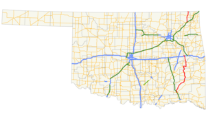
413:, covering 116.7 miles (187.8 km) through the southeastern part of the state. The northern SH-2 runs for 26.3 miles (42.3 km) through
73:
1504:
318:
313:
654:
561:
549:
513:
505:
489:
478:
474:
462:
454:
610:
The section of SH-2 between I-40 and SH-9 was pressed into service as a detour for eastbound I-40 traffic after the
990:
835:
701:
541:
537:
521:
501:
470:
442:
406:
196:
137:
123:
1195:
1191:
1161:
1135:
1131:
1040:
1014:
966:
947:
888:
784:
747:
557:
234:
230:
192:
165:
1145:
938:
869:
780:
756:
675:
571:
All signage for SH-2 ends at US-59/SH-10 in Welch. However, the official definition of the highway contains an
517:
358:
343:
151:
101:
1226:
253:
1534:
1105:
466:
414:
1406:
488:
SH-2 then passes
Robbers Cave State Park and the eastern edge of the Sansbois Mountains before reaching
323:
922:
611:
553:
155:
1389:
845:
482:
141:
1362:
1343:(Map) (2010–2011 ed.). Scale not given. Oklahoma City: Oklahoma Department of Transportation
1244:
1060:
458:
391:
1335:
1466:
685:
659:
595:
493:
450:
402:
127:
105:
1110:
1024:
591:
572:
545:
525:
435:
410:
238:
169:
1170:
898:
565:
509:
497:
45:
17:
599:
446:
1498:
383:
273:
1364:
Map
Showing Condition of Improvement of the State Highway System and Landing Fields
395:
575:
concurrency with US-59 to the point where it crosses the state line into Kansas.
1312:
1280:
584:
583:
The northern SH-2, between Vinita and the Kansas state line, was once part of
504:. Three miles (4.9 km) later, the highway passes the eastern terminus of
445:
in
Antlers. It travels north-northwest from here, roughly parallelling the
387:
283:
516:, which it will overlap until its end. After having an interchange at
430:
398:, so the middle section was decommissioned for reasons of redundancy.
59:
1474:
390:. Though they were once connected, the middle section of highway was
1213:
1180:
984:
908:
882:
855:
829:
802:
769:
719:
695:
429:
1370:(Map) (February 1934 ed.). Oklahoma Department of Highways
382:, is a designation for two distinct highways maintained by the
1489:
1484:
496:, and the two form a six-mile (10 km) concurrency until
1234:
1.000 mi = 1.609 km; 1.000 km = 0.621 mi
1050:
1.000 mi = 1.609 km; 1.000 km = 0.621 mi
461:
for 3 miles (5 km). Immediately after this, SH-2 meets
500:. Ten miles (16 km) north of here, Highway 2 meets
1462:
1457:
556:. Six miles north of here, it comes to a junction with
1199:
994:
916:
892:
863:
839:
815:
788:
727:
705:
1045:
Northern terminus of SH-2, eastern terminus of US-266
1334:Oklahoma Department of Transportation (2010–2011).
293:
279:
269:
264:
244:
216:
208:
203:
178:
111:
92:
84:
79:
66:
41:
30:"OK 2" redirects here. The term may also refer to
1407:"I-40 Webbers Falls Local Detour Route & Map"
1476:Template:Attached KML/Oklahoma State Highway 2
612:collapse of its bridge over the Arkansas River
1510:Transportation in Pushmataha County, Oklahoma
8:
520:milemarker 278, both SH-2 and US-266 end at
469:. SH-2 then crosses over the lake and meets
1525:Transportation in Muskogee County, Oklahoma
1520:Transportation in Haskell County, Oklahoma
1515:Transportation in Latimer County, Oklahoma
1077:
626:
512:. 10 miles (16 km) later, SH-2 meets
401:The southern section of highway runs from
332:
1479:
457:. North of Clayton, Highway 2 and US-271
1530:Transportation in Craig County, Oklahoma
1395:. Oklahoma Department of Transportation.
27:State highway in Oklahoma, United States
1409:. Oklahoma Department of Transportation
1302:
1300:
1298:
1270:
1268:
1266:
1262:
441:The southern section of SH-2 begins at
816:Northern end of SH-1/SH-63 concurrency
789:Southern end of SH-1/SH-63 concurrency
38:
1490:SH-2's northern section at OKHighways
1485:SH-2's southern section at OKHighways
1207:
1204:
1174:
1155:
1149:
1120:
1114:
1034:
1028:
1008:
1002:
978:
960:
954:
932:
926:
902:
876:
849:
823:
796:
763:
741:
735:
713:
689:
669:
663:
33:Oklahoma's 2nd congressional district
7:
548:. It then heads due north, meeting
1337:Control Section Maps: Craig County
1092:
995:Southern end of US-266 concurrency
864:Northern end of US-270 concurrency
840:Southern end of US-270 concurrency
728:Northern end of US-271 concurrency
706:Southern end of US-271 concurrency
641:
88:116.7 mi (187.8 km)
25:
1200:Southern end of US-59 concurrency
552:four miles (6.5 km) west of
465:'s eastern terminus southeast of
1429:"Truckers weigh cost of detours"
1221:
1214:
1186:
1181:
1156:
1126:
1121:
1035:
1009:
985:
961:
933:
917:Eastern end of SH-31 concurrency
909:
893:Western end of SH-31 concurrency
883:
856:
830:
808:
803:
775:
770:
742:
720:
696:
670:
434:The end of US-266 and SH-2 near
353:
338:
248:
225:
220:
212:26.3 mi (42.3 km)
187:
182:
160:
146:
132:
118:
96:
58:
44:
1:
1427:Stewart, D. R. (2002-05-29).
1087:
636:
302:Oklahoma State Highway System
536:The northern SH-2 begins at
1229:continues north into Kansas
1551:
1505:State highways in Oklahoma
1308:"Oklahoma State Highway 2"
1276:"Oklahoma State Highway 2"
1205:Oklahoma–Kansas state line
417:in northeastern Oklahoma.
29:
18:State Highway 2 (Oklahoma)
1233:
1210:
1177:
1169:
1165:
1152:
1144:
1139:
1117:
1109:
1104:
1099:
1096:
1091:
1086:
1083:
1080:
1049:
1044:
1031:
1023:
1018:
1005:
999:
981:
975:
971:Eastern terminus of SH-71
970:
957:
951:
946:
942:
929:
921:
905:
897:
879:
873:
868:
852:
844:
826:
820:
799:
793:
766:
760:
755:
751:
738:
732:
716:
710:
692:
684:
679:
666:
658:
653:
648:
645:
640:
635:
632:
629:
331:
298:
289:
260:
71:
57:
1240:
1056:
256:at the Kansas state line
508:, south of the town of
438:
433:
394:with three different
1480:KML is from Wikidata
112:Major intersections
439:
421:Route descriptions
1255:
1254:
1140:Southern terminus
1071:
1070:
813:SH-1 / SH-63
680:Southern terminus
614:on May 26, 2002.
596:Stanley, Oklahoma
449:, until reaching
369:
368:
365:
364:
67:Route information
16:(Redirected from
1542:
1470:
1443:
1442:
1440:
1439:
1424:
1418:
1417:
1415:
1414:
1403:
1397:
1396:
1394:
1386:
1380:
1379:
1377:
1375:
1369:
1359:
1353:
1352:
1350:
1348:
1342:
1331:
1325:
1324:
1322:
1320:
1304:
1293:
1292:
1290:
1288:
1272:
1248:
1241:
1225:
1224:
1218:
1217:
1190:
1189:
1185:
1184:
1160:
1159:
1130:
1129:
1125:
1124:
1094:
1089:
1078:
1074:Northern section
1064:
1057:
1039:
1038:
1013:
1012:
989:
988:
965:
964:
937:
936:
913:
912:
887:
886:
860:
859:
834:
833:
812:
811:
807:
806:
779:
778:
774:
773:
746:
745:
724:
723:
700:
699:
674:
673:
643:
638:
627:
623:Southern section
592:Kosoma, Oklahoma
532:Northern section
426:Southern section
361:
357:
356:
346:
342:
341:
333:
252:
251:
229:
228:
224:
223:
191:
190:
186:
185:
164:
163:
150:
149:
136:
135:
122:
121:
100:
99:
62:
48:
39:
35:
21:
1550:
1549:
1545:
1544:
1543:
1541:
1540:
1539:
1495:
1494:
1481:
1478:
1473:
1472:
1471:
1455:
1451:
1446:
1437:
1435:
1426:
1425:
1421:
1412:
1410:
1405:
1404:
1400:
1392:
1390:"Oklahoma 1970"
1388:
1387:
1383:
1373:
1371:
1367:
1361:
1360:
1356:
1346:
1344:
1340:
1333:
1332:
1328:
1318:
1316:
1306:
1305:
1296:
1286:
1284:
1274:
1273:
1264:
1260:
1251:
1243:
1239:
1235:
1222:
1220:
1215:
1187:
1182:
1157:
1146:Pyramid Corners
1127:
1122:
1076:
1067:
1059:
1055:
1051:
1036:
1010:
986:
962:
934:
910:
884:
857:
831:
809:
804:
776:
771:
743:
721:
697:
671:
625:
620:
581:
566:Welch, Oklahoma
534:
510:Porum, Oklahoma
428:
423:
407:U.S. Highway 64
372:State Highway 2
354:
352:
339:
337:
249:
226:
221:
188:
183:
174:
161:
147:
133:
119:
97:
53:
52:
51:State Highway 2
49:
37:
31:
28:
23:
22:
15:
12:
11:
5:
1548:
1546:
1538:
1537:
1532:
1527:
1522:
1517:
1512:
1507:
1497:
1496:
1493:
1492:
1487:
1454:
1453:
1452:
1450:
1449:External links
1447:
1445:
1444:
1419:
1398:
1381:
1354:
1326:
1294:
1261:
1259:
1256:
1253:
1252:
1250:
1249:
1236:
1231:
1230:
1212:
1209:
1206:
1202:
1201:
1198:
1179:
1176:
1173:
1167:
1166:
1164:
1154:
1151:
1148:
1142:
1141:
1138:
1119:
1116:
1113:
1108:
1102:
1101:
1098:
1095:
1090:
1085:
1082:
1075:
1072:
1069:
1068:
1066:
1065:
1052:
1047:
1046:
1043:
1033:
1030:
1027:
1021:
1020:
1017:
1007:
1004:
1001:
997:
996:
993:
983:
980:
977:
973:
972:
969:
959:
956:
953:
950:
944:
943:
941:
931:
928:
925:
919:
918:
915:
907:
904:
901:
895:
894:
891:
881:
878:
875:
872:
866:
865:
862:
854:
851:
848:
842:
841:
838:
828:
825:
822:
818:
817:
814:
801:
798:
795:
791:
790:
787:
768:
765:
762:
759:
753:
752:
750:
740:
737:
734:
730:
729:
726:
718:
715:
712:
708:
707:
704:
694:
691:
688:
682:
681:
678:
668:
665:
662:
657:
651:
650:
647:
644:
639:
634:
631:
624:
621:
619:
616:
600:Kiamichi River
580:
577:
533:
530:
447:Kiamichi River
427:
424:
422:
419:
374:, abbreviated
367:
366:
363:
362:
349:
347:
329:
328:
327:
326:
321:
316:
311:
305:
304:
296:
295:
294:Highway system
291:
290:
287:
286:
281:
277:
276:
271:
267:
266:
262:
261:
258:
257:
246:
245:North end
242:
241:
218:
217:South end
214:
213:
210:
206:
205:
201:
200:
180:
179:North end
176:
175:
173:
172:
158:
144:
130:
115:
113:
109:
108:
94:
93:South end
90:
89:
86:
82:
81:
77:
76:
72:Maintained by
69:
68:
64:
63:
55:
54:
50:
43:
42:
26:
24:
14:
13:
10:
9:
6:
4:
3:
2:
1547:
1536:
1535:U.S. Route 73
1533:
1531:
1528:
1526:
1523:
1521:
1518:
1516:
1513:
1511:
1508:
1506:
1503:
1502:
1500:
1491:
1488:
1486:
1483:
1482:
1477:
1468:
1464:
1460:
1459:
1448:
1434:
1430:
1423:
1420:
1408:
1402:
1399:
1391:
1385:
1382:
1366:
1365:
1358:
1355:
1339:
1338:
1330:
1327:
1315:
1314:
1309:
1303:
1301:
1299:
1295:
1283:
1282:
1277:
1271:
1269:
1267:
1263:
1257:
1246:
1238:
1237:
1232:
1228:
1203:
1197:
1193:
1172:
1168:
1163:
1147:
1143:
1137:
1133:
1112:
1107:
1103:
1079:
1073:
1062:
1054:
1053:
1048:
1042:
1026:
1022:
1019:I-40 exit 278
1016:
998:
992:
974:
968:
949:
945:
940:
924:
920:
900:
896:
890:
871:
867:
847:
843:
837:
819:
792:
786:
782:
758:
754:
749:
731:
709:
703:
687:
683:
677:
661:
656:
652:
628:
622:
618:Junction list
617:
615:
613:
608:
604:
601:
597:
593:
588:
586:
578:
576:
574:
569:
567:
563:
559:
555:
551:
547:
543:
539:
531:
529:
527:
523:
519:
515:
511:
507:
503:
499:
495:
491:
486:
484:
480:
476:
472:
468:
464:
460:
456:
452:
448:
444:
437:
432:
425:
420:
418:
416:
412:
408:
404:
399:
397:
396:U.S. highways
393:
389:
385:
381:
377:
373:
360:
350:
348:
345:
335:
334:
330:
325:
322:
320:
317:
315:
312:
310:
307:
306:
303:
300:
299:
297:
292:
288:
285:
282:
278:
275:
274:United States
272:
268:
263:
259:
255:
247:
243:
240:
236:
232:
219:
215:
211:
207:
202:
198:
194:
181:
177:
171:
167:
159:
157:
153:
145:
143:
139:
131:
129:
125:
117:
116:
114:
110:
107:
103:
95:
91:
87:
83:
78:
75:
70:
65:
61:
56:
47:
40:
34:
19:
1456:
1436:. Retrieved
1432:
1422:
1411:. Retrieved
1401:
1384:
1372:. Retrieved
1363:
1357:
1345:. Retrieved
1336:
1329:
1317:. Retrieved
1311:
1285:. Retrieved
1279:
1242:
1097:Destinations
1058:
646:Destinations
609:
605:
589:
582:
570:
535:
487:
440:
415:Craig County
400:
379:
375:
371:
370:
301:
1433:Tulsa World
1347:October 28,
1319:October 30,
1313:Google Maps
1287:October 28,
1281:Google Maps
1245:Concurrency
1061:Concurrency
991:US 266
861:US 270
836:US 270
725:US 271
702:US 271
467:Sardis Lake
197:US 266
138:US 270
124:US 271
1499:Categories
1438:2014-01-10
1413:2014-01-10
1258:References
1192:US 59
1136:US 69
1132:US 60
1041:US 64
923:Whitefield
655:Pushmataha
554:Bluejacket
392:concurrent
309:Interstate
235:US 69
231:US 60
193:US 64
156:Whitefield
1219:SH-2 ends
846:Wilburton
483:Wilburton
386:state of
324:Turnpikes
204:Section 2
199:in Warner
142:Wilburton
80:Section 1
1458:KML file
1247:terminus
1194: /
1134: /
1084:Location
1063:terminus
948:Muskogee
783: /
633:Location
573:unsigned
492:east of
388:Oklahoma
284:Oklahoma
265:Location
233: /
195: /
104:west of
1374:May 10,
1310:(Map).
1278:(Map).
1000:
976:
952:
874:
870:Haskell
821:
794:
761:
757:Latimer
733:
711:
686:Clayton
660:Antlers
598:in the
579:History
494:Quinton
459:overlap
451:Clayton
403:Antlers
270:Country
128:Clayton
106:Antlers
1111:Vinita
1081:County
1025:Warner
630:County
546:Vinita
526:Warner
514:US-266
479:US-270
455:US-271
436:Warner
411:Warner
239:Vinita
209:Length
170:Warner
85:Length
1393:(PDF)
1368:(PDF)
1341:(PDF)
1227:US-59
1196:SH-10
1171:Welch
1162:SH-25
1106:Craig
1100:Notes
1032:187.8
1029:116.7
1006:185.2
1003:115.1
982:183.5
979:114.0
967:SH-71
958:168.2
955:104.5
930:158.7
914:SH-31
906:142.4
899:Kinta
889:SH-31
880:133.3
853:102.7
827:101.9
785:SH-63
748:SH-43
649:Notes
585:US-73
562:SH-10
558:US-59
550:SH-25
542:US-69
538:US-60
524:near
522:US-64
506:SH-71
498:Kinta
490:SH-31
475:SH-63
463:SH-43
409:near
319:State
280:State
254:US-59
1467:help
1463:edit
1376:2013
1349:2012
1321:2012
1289:2012
1211:42.3
1208:26.3
1178:27.8
1175:17.3
1153:18.3
1150:11.4
1015:I-40
939:SH-9
927:98.6
903:88.5
877:82.8
850:63.8
824:63.3
800:83.0
797:51.6
781:SH-1
767:73.2
764:45.5
739:62.4
736:38.8
717:59.1
714:36.7
693:53.8
690:33.4
676:SH-3
594:and
560:and
518:I-40
502:SH-9
471:SH-1
453:and
443:SH-3
384:U.S.
380:OK-2
376:SH-2
359:SH-3
344:SH-1
166:I-40
152:SH-9
102:SH-3
74:ODOT
1118:0.0
1115:0.0
667:0.0
664:0.0
564:in
544:in
481:at
405:to
378:or
237:in
168:in
154:in
140:in
126:in
1501::
1465:•
1431:.
1297:^
1265:^
1093:km
1088:mi
642:km
637:mi
587:.
568:.
528:.
485:.
351:→
336:←
314:US
1469:)
1461:(
1441:.
1416:.
1378:.
1351:.
1323:.
1291:.
540:/
473:/
36:.
20:)
Text is available under the Creative Commons Attribution-ShareAlike License. Additional terms may apply.