37:
370:
218:
203:
97:
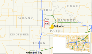
306:, around two miles (3.2 km) north of SH-51. SH-86 crosses into Noble County 3.01 miles (4.84 km) into its journey. In Noble County, the highway mostly follows a due north course, except for a slight curve approximately two miles (3.2 km) south of Perry. The route passes just west of Lake Perry. Shortly thereafter, SH-86 comes to an end in Perry at
51:
401:
113:
318:
State
Highway 86 first appears on the official Oklahoma highway map on the 1941 edition. Originally, the driving surface consisted of untreated gravel. The route had the same extent and termini as the present-day highway. By 1953, the highway had been paved.
630:
625:
596:
171:
64:
620:
181:
176:
551:
277:
307:
404:
373:
299:
221:
206:
116:
100:
383:
354:
262:
258:
186:
303:
542:
515:
479:(Map) (2010–2011 ed.). Scale not given. Oklahoma City: Oklahoma Department of Transportation
448:(Map) (2010–2011 ed.). Scale not given. Oklahoma City: Oklahoma Department of Transportation
471:
440:
587:
268:
SH-86 was established in 1940. Initially a gravel highway, it remained unpaved until 1952.
36:
17:
388:
254:
614:
295:
136:
250:
242:
257:
and is 12.06 miles (19.41 km) long. The highway is contained wholly in
246:
146:
50:
595:
605:
517:
Map
Showing Condition of Improvement of the State Highway System
523:(Map) (April 1941 ed.). Oklahoma Department of Highways
414:
1.000 mi = 1.609 km; 1.000 km = 0.621 mi
583:
578:
298:. From this intersection, SH-86 heads north, crossing
465:
463:
434:
432:
430:
470:Oklahoma Department of Transportation (2010–2011).
439:Oklahoma Department of Transportation (2010–2011).
156:
142:
132:
127:
107:
91:
86:
78:
70:
57:
32:
265:Counties. SH-86 has no lettered spurs or loops.
597:Template:Attached KML/Oklahoma State Highway 86
8:
504:(Map). 1:200,000. DeLorme. 2006. p. 32.
326:
195:
600:
496:
494:
631:Transportation in Noble County, Oklahoma
626:Transportation in Payne County, Oklahoma
302:, just west of where it expands to form
27:State highway in Oklahoma, United States
426:
280:in western Payne County, approximately
29:
398:
392:
367:
361:
7:
473:Control Section Maps: Noble County
442:Control Section Maps: Payne County
341:
74:12.06 mi (19.41 km)
25:
399:
368:
216:
201:
111:
95:
49:
35:
552:Oklahoma Department of Highways
1:
336:
165:Oklahoma State Highway System
502:Oklahoma Atlas and Gazetteer
294:miles (5.6 km) east of
241:) is a state highway in the
18:State Highway 86 (Oklahoma)
647:
621:State highways in Oklahoma
413:
408:
395:
387:
382:
377:
364:
358:
353:
348:
345:
340:
335:
332:
329:
194:
161:
152:
123:
62:
48:
601:KML is from Wikidata
544:Highways of Oklahoma
606:SH-86 at OKHighways
304:Lake Carl Blackwell
103:west of Stillwater
419:
418:
409:Northern terminus
378:Southern terminus
272:Route description
232:
231:
228:
227:
58:Route information
16:(Redirected from
638:
591:
564:
563:
561:
559:
549:
539:
533:
532:
530:
528:
522:
512:
506:
505:
498:
489:
488:
486:
484:
478:
467:
458:
457:
455:
453:
447:
436:
403:
402:
372:
371:
343:
338:
327:
300:Stillwater Creek
293:
292:
288:
285:
276:SH-86 begins at
235:State Highway 86
224:
220:
219:
209:
205:
204:
196:
115:
114:
99:
98:
53:
42:State Highway 86
39:
30:
21:
646:
645:
641:
640:
639:
637:
636:
635:
611:
610:
602:
599:
594:
593:
592:
576:
572:
567:
557:
555:
547:
541:
540:
536:
526:
524:
520:
514:
513:
509:
500:
499:
492:
482:
480:
476:
469:
468:
461:
451:
449:
445:
438:
437:
428:
424:
415:
400:
369:
325:
316:
290:
286:
283:
281:
274:
217:
215:
202:
200:
112:
96:
87:Major junctions
44:
43:
40:
28:
23:
22:
15:
12:
11:
5:
644:
642:
634:
633:
628:
623:
613:
612:
609:
608:
575:
574:
573:
571:
570:External links
568:
566:
565:
534:
507:
490:
459:
425:
423:
420:
417:
416:
411:
410:
407:
397:
394:
391:
386:
380:
379:
376:
366:
363:
360:
357:
351:
350:
347:
344:
339:
334:
331:
324:
321:
315:
312:
273:
270:
249:that connects
230:
229:
226:
225:
212:
210:
192:
191:
190:
189:
184:
179:
174:
168:
167:
159:
158:
157:Highway system
154:
153:
150:
149:
144:
140:
139:
134:
130:
129:
125:
124:
121:
120:
109:
108:North end
105:
104:
93:
92:South end
89:
88:
84:
83:
80:
76:
75:
72:
68:
67:
63:Maintained by
60:
59:
55:
54:
46:
45:
41:
34:
33:
26:
24:
14:
13:
10:
9:
6:
4:
3:
2:
643:
632:
629:
627:
624:
622:
619:
618:
616:
607:
604:
603:
598:
589:
585:
581:
580:
569:
553:
546:
545:
538:
535:
519:
518:
511:
508:
503:
497:
495:
491:
483:September 27,
475:
474:
466:
464:
460:
452:September 27,
444:
443:
435:
433:
431:
427:
421:
412:
406:
390:
385:
381:
375:
356:
352:
328:
323:Junction list
322:
320:
313:
311:
309:
305:
301:
297:
296:Interstate 35
279:
271:
269:
266:
264:
260:
256:
252:
248:
244:
240:
237:(abbreviated
236:
223:
213:
211:
208:
198:
197:
193:
188:
185:
183:
180:
178:
175:
173:
170:
169:
166:
163:
162:
160:
155:
151:
148:
145:
141:
138:
137:United States
135:
131:
126:
122:
118:
110:
106:
102:
94:
90:
85:
81:
77:
73:
69:
66:
61:
56:
52:
47:
38:
31:
19:
577:
556:. Retrieved
543:
537:
525:. Retrieved
516:
510:
501:
481:. Retrieved
472:
450:. Retrieved
441:
346:Destinations
317:
275:
267:
238:
234:
233:
164:
82:1940–present
558:December 1,
527:December 1,
615:Categories
422:References
405:US 77
243:U.S. state
172:Interstate
117:US 77
187:Turnpikes
579:KML file
333:Location
247:Oklahoma
147:Oklahoma
128:Location
119:in Perry
550:(Map).
359:
314:History
289:⁄
133:Country
79:Existed
554:. 1953
330:County
71:Length
548:(PDF)
521:(PDF)
477:(PDF)
446:(PDF)
396:19.41
393:12.06
389:Perry
384:Noble
374:SH-51
355:Payne
349:Notes
308:US-77
278:SH-51
263:Noble
259:Payne
255:Perry
253:with
251:SH-51
239:SH-86
222:SH-87
207:SH-85
182:State
143:State
101:SH-51
588:help
584:edit
560:2012
529:2012
485:2012
454:2012
365:0.00
362:0.00
261:and
65:ODOT
245:of
617::
586:•
493:^
462:^
429:^
342:km
337:mi
310:.
214:→
199:←
177:US
590:)
582:(
562:.
531:.
487:.
456:.
291:2
287:1
284:+
282:3
20:)
Text is available under the Creative Commons Attribution-ShareAlike License. Additional terms may apply.