389:
627:
109:
44:
285:
270:
63:
704:
146:
670:
130:
788:
561:
at St. Clair Bottom to SR 16 southwest of Sugar Grove in 1945; the part from St. Clair Bottom west to Lodi became an extension of SR 79. The next year, the piece from US 21 north of
Speedwell towards Porters Crossroads became a secondary route, as it was a "stub end primary route that could be
364:, and Austinville to today's SR 69. However, it was never fully continuous; portions from Sugar Grove to Cedar Springs and west of Porters Crossroads to east of Austinville were secondary routes. The full length of this route as it existed and was planned is now part of
388:
365:
1015:
961:
238:
233:
1025:
630:
223:
112:
570:
at Cedar
Springs became an extension of SR 90. This left only the present SR 69, which was renumbered in 1958 to avoid conflicting with the new
985:
248:
76:
1010:
992:
980:
456:
31:
535:
480:
460:
441:
228:
373:
558:
519:
563:
523:
511:
723:
531:
215:
476:
361:
707:
567:
547:
507:
449:
421:
397:
369:
337:
325:
149:
345:
673:
641:
571:
543:
484:
464:
445:
405:
377:
196:
133:
396:
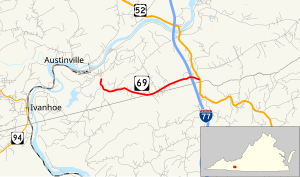
SR 69 begins at an intersection with SR 636 (Store Hill Road) just south of the village of
Austinville on the
332:. SR 69 is the last remnant of a much longer route. At its peak from 1940 to 1945, this route (then numbered
472:
353:
711:
677:
288:
273:
243:
691:
488:
329:
153:
1020:
654:
609:
401:
192:
773:
499:. This was the last piece of the Lodi-Poplar Camp route to be added to the primary state highway system.
834:
759:
614:
492:
479:
for 6.94 miles (11.17 km) to a point west of present SR 642. A 3.50-mile (5.63 km) piece from
349:
321:
116:
920:
902:
884:
866:
848:
815:
719:
681:
514:; the pieces of SR 115 east of Cedar Springs, plus a proposed extension west to Sugar Grove, became
715:
468:
417:
357:
452:
253:
17:
952:
503:
409:
546:
was relocated to the south, and SR 91 was extended southwest and west from Sugar Grove along
542:
designation was used for the former SR 91 from Sugar Grove to Poplar Camp. At the same time,
413:
970:
551:
433:
408:
county line, which the highway travels atop for a short distance through the hamlet of
341:
380:, part of SR 690, a small piece of SR 642, part of SR 619, part of SR 636, and SR 69.
1004:
437:
309:
172:
557:
The first section of this route to be transferred to the secondary system was from
424:
before reaching its eastern terminus at US 52 (Fort
Chiswell Road) in Poplar Camp.
793:
459:, the first new pieces of the route were added in 1928. These sections ran from
574:. (The two pieces that became SR 79 and SR 90 are now also secondary routes.)
527:
372:(and SR 695, its former alignment at Sugar Grove), all of SR 614, part of
400:. The state highway heads east parallel to Poplar Camp Mountain and the
313:
182:
43:
62:
960:
387:
320:, the state highway runs 3.59 miles (5.78 km) from SR 636 in
455:, which was added to the state highway system in 1931 as part of
502:
Several other pieces of SR 115 from Cedar
Springs north through
733:
1.000 mi = 1.609 km; 1.000 km = 0.621 mi
847:
State
Highway Commission of Virginia (December 18, 1930).
814:
State
Highway Commission of Virginia (August 9–10, 1928).
926:(Report). Richmond: Commonwealth of Virginia. p. 12.
890:(Report). Richmond: Commonwealth of Virginia. p. 14.
872:(Report). Richmond: Commonwealth of Virginia. p. 13.
865:
State
Highway Commission of Virginia (October 10, 1940).
821:(Report). Richmond: Commonwealth of Virginia. p. 14.
908:(Report). Richmond: Commonwealth of Virginia. p. 5.
854:(Report). Richmond: Commonwealth of Virginia. p. 5.
948:
943:
919:
State
Highway Commission of Virginia (March 18, 1958).
901:
State
Highway Commission of Virginia (May 2–3, 1946).
883:
State Highway Commission of Virginia (May 22, 1945).
566:
of 201 in 1941, and the route from Speedwell west to
754:
752:
750:
206:
188:
178:
168:
163:
140:
122:
103:
98:
90:
82:
69:
39:
475:and from SR 26 north of Speedwell east towards
962:Template:Attached KML/Virginia State Route 69
762:. Virginia Department of Transportation. 2009
8:
392:View west along SR 69 at I-77 in Poplar Camp
830:
828:
975:
581:
262:
965:
368:, part of SR 660, all of SR 650, part of
1016:Transportation in Wythe County, Virginia
991:
978:
506:were added in 1930 and 1932, but became
746:
986:District 1 State Routes
440:, what later became SR 81 was part of
36:
701:
695:
667:
661:
633:(Store Hill Road / Loafers Rest Road)
624:
618:
27:State highway in western Virginia, US
7:
32:State Route 69 (Virginia 1933-1951)
30:For the former State Route 69, see
596:
25:
971:Virginia Highways Project: VA 69
702:
668:
625:
562:transferred with logic" with an
412:. SR 69 expands to a four-lane
283:
268:
144:
128:
107:
86:3.59 mi (5.78 km)
61:
42:
1026:1958 establishments in Virginia
18:State Route 116 (Virginia 1930)
522:designation was needed in the
1:
591:
710:(Fort Chiswell Road) –
564:annual average daily traffic
448:until 1940. Other than the
1042:
1011:State highways in Virginia
724:Shot Tower Historical Park
29:
984:
789:"Virginia State Route 69"
732:
727:
698:
690:
685:
664:
658:
653:
648:
640:
635:
621:
613:
608:
603:
600:
595:
590:
587:
584:
261:
211:
202:
159:
74:
60:
55:
495:, was added in 1930 as
837:, revised July 1, 1936
393:
391:
312:in the U.S. state of
966:KML is from Wikidata
921:"Minutes of Meeting"
903:"Minutes of Meeting"
885:"Minutes of Meeting"
867:"Minutes of Meeting"
849:"Minutes of Meeting"
816:"Minutes of Meeting"
550:and former US 58 to
835:Map of Wythe County
760:"2009 Traffic Data"
578:Major intersections
418:diamond interchange
124:Major intersections
649:No major junctions
477:Porters Crossroads
394:
362:Porters Crossroads
999:
998:
738:
737:
646:
384:Route description
299:
298:
295:
294:
70:Route information
16:(Redirected from
1033:
976:
956:
928:
927:
925:
916:
910:
909:
907:
898:
892:
891:
889:
880:
874:
873:
871:
862:
856:
855:
853:
844:
838:
832:
823:
822:
820:
811:
805:
804:
802:
801:
785:
779:
770:
768:
767:
756:
728:Eastern terminus
706:
705:
672:
671:
645:
636:Western terminus
629:
628:
598:
593:
582:
524:1940 renumbering
512:1933 renumbering
346:St. Clair Bottom
291:
287:
286:
276:
272:
271:
263:
148:
147:
132:
131:
125:
111:
110:
65:
46:
37:
21:
1041:
1040:
1036:
1035:
1034:
1032:
1031:
1030:
1001:
1000:
988:
967:
964:
959:
958:
957:
941:
937:
932:
931:
923:
918:
917:
913:
905:
900:
899:
895:
887:
882:
881:
877:
869:
864:
863:
859:
851:
846:
845:
841:
833:
826:
818:
813:
812:
808:
799:
797:
787:
786:
782:
765:
763:
758:
757:
748:
743:
734:
703:
669:
644:
626:
580:
497:State Route 116
457:State Route 113
444:until 1933 and
430:
414:divided highway
386:
308:) is a primary
284:
282:
269:
267:
216:Virginia Routes
145:
129:
123:
108:
99:Major junctions
51:
50:
47:
35:
28:
23:
22:
15:
12:
11:
5:
1039:
1037:
1029:
1028:
1023:
1018:
1013:
1003:
1002:
997:
996:
990:
983:
974:
973:
940:
939:
938:
936:
935:External links
933:
930:
929:
911:
893:
875:
857:
839:
824:
806:
780:
778:
777:
745:
744:
742:
739:
736:
735:
730:
729:
726:
700:
697:
694:
688:
687:
686:Exit 24 (I-77)
684:
666:
663:
660:
657:
651:
650:
647:
638:
637:
634:
623:
620:
617:
612:
606:
605:
602:
599:
594:
589:
586:
579:
576:
568:State Route 90
559:State Route 79
548:State Route 16
540:State Route 81
536:State Route 81
534:on the former
532:State Route 91
520:State Route 91
516:State Route 91
508:State Route 90
481:State Route 15
461:State Route 26
450:State Route 16
442:State Route 12
429:
426:
385:
382:
338:State Route 91
334:State Route 81
318:Lead Mine Road
302:State Route 69
297:
296:
293:
292:
279:
277:
259:
258:
257:
256:
251:
246:
241:
236:
231:
226:
220:
219:
209:
208:
207:Highway system
204:
203:
200:
199:
190:
186:
185:
180:
176:
175:
170:
166:
165:
161:
160:
157:
156:
142:
138:
137:
136:at Poplar Camp
126:
120:
119:
105:
101:
100:
96:
95:
92:
88:
87:
84:
80:
79:
75:Maintained by
72:
71:
67:
66:
58:
57:
56:Lead Mine Road
53:
52:
49:State Route 69
48:
41:
40:
26:
24:
14:
13:
10:
9:
6:
4:
3:
2:
1038:
1027:
1024:
1022:
1021:U.S. Route 58
1019:
1017:
1014:
1012:
1009:
1008:
1006:
994:
987:
982:
977:
972:
969:
968:
963:
954:
950:
946:
945:
934:
922:
915:
912:
904:
897:
894:
886:
879:
876:
868:
861:
858:
850:
843:
840:
836:
831:
829:
825:
817:
810:
807:
796:
795:
790:
784:
781:
775:
772:
771:
761:
755:
753:
751:
747:
740:
731:
725:
721:
717:
713:
712:Fort Chiswell
709:
693:
689:
683:
679:
678:Fort Chiswell
675:
656:
652:
643:
639:
632:
616:
611:
607:
583:
577:
575:
573:
572:Interstate 81
569:
565:
560:
555:
553:
549:
545:
544:U.S. Route 58
541:
537:
533:
529:
525:
521:
517:
513:
509:
505:
504:Rural Retreat
500:
498:
494:
490:
486:
485:U.S. Route 52
482:
478:
474:
473:Cedar Springs
470:
466:
465:U.S. Route 21
462:
458:
454:
451:
447:
446:U.S. Route 58
443:
439:
435:
427:
425:
423:
422:Interstate 77
419:
415:
411:
407:
403:
399:
390:
383:
381:
379:
375:
371:
367:
363:
359:
355:
354:Cedar Springs
351:
347:
343:
339:
335:
331:
327:
326:U.S. Route 52
323:
319:
315:
311:
310:state highway
307:
303:
290:
280:
278:
275:
265:
264:
260:
255:
252:
250:
247:
245:
242:
240:
237:
235:
232:
230:
227:
225:
222:
221:
218:
217:
213:
212:
210:
205:
201:
198:
194:
191:
187:
184:
181:
177:
174:
173:United States
171:
167:
162:
158:
155:
151:
143:
141:East end
139:
135:
127:
121:
118:
114:
106:
104:West end
102:
97:
93:
89:
85:
81:
78:
73:
68:
64:
59:
54:
45:
38:
33:
19:
942:
914:
896:
878:
860:
842:
809:
798:. Retrieved
792:
783:
774:Wythe County
764:. Retrieved
601:Destinations
556:
539:
515:
501:
496:
436:to north of
431:
416:through its
395:
333:
317:
316:. Known as
305:
301:
300:
214:
94:1958–present
995: >
993:SR 117
981:SR 114
794:Google Maps
692:Poplar Camp
631:SR 636
615:Austinville
493:Austinville
489:Poplar Camp
453:concurrency
350:Sugar Grove
336:) ran from
330:Poplar Camp
328:(US 52) in
322:Austinville
154:Poplar Camp
117:Austinville
113:SR 636
1005:Categories
989:1928–1933
979:<
800:2011-09-10
766:2011-09-10
741:References
720:Hillsville
708:US 52
682:Hillsville
538:, so this
376:, part of
289:SR 70
274:SR 68
224:Interstate
150:US 52
716:Bluefield
528:Tennessee
526:to match
469:Speedwell
438:Troutdale
398:New River
358:Speedwell
344:east via
254:HOT lanes
239:Secondary
944:KML file
676: –
588:Location
491:towards
471:west to
324:east to
314:Virginia
189:Counties
183:Virginia
164:Location
791:(Map).
659:
642:Carroll
510:in the
428:History
410:Bethany
406:Carroll
404:–
249:History
234:Primary
197:Carroll
169:Country
91:Existed
585:County
518:. The
374:SR 749
366:SR 762
244:Byways
83:Length
924:(PDF)
906:(PDF)
888:(PDF)
870:(PDF)
852:(PDF)
819:(PDF)
776:(PDF)
655:Wythe
610:Wythe
604:Notes
483:(now
467:) at
463:(now
432:From
420:with
402:Wythe
378:US 21
370:SR 16
306:SR 69
193:Wythe
179:State
953:help
949:edit
699:5.78
696:3.59
674:I-77
665:5.29
662:3.29
622:0.00
619:0.00
552:Lodi
434:Lodi
342:Lodi
134:I-77
77:VDOT
530:'s
487:at
340:at
152:at
115:in
1007::
951:•
827:^
749:^
722:,
718:,
714:,
680:,
597:km
592:mi
554:.
360:,
356:,
352:,
348:,
281:→
266:←
229:US
195:,
955:)
947:(
803:.
769:.
304:(
34:.
20:)
Text is available under the Creative Commons Attribution-ShareAlike License. Additional terms may apply.