349:
88:
373:
55:
361:
38:
693:
95:
62:
348:
317:
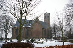
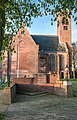
The village was first mentioned in 1680 as Kerck. The current name means "stubby tower" after the shape of the Dutch
Reformed church tower. Stompetoren developed after the Schermer was
547:
674:
87:
734:
753:
179:
540:
271:
763:
334:
style and surrounded by a moat. It was constructed in 1889 and replaces a farm. Between 1986 and 1987, it was converted to serve as town hall.
283:
727:
533:
54:
360:
372:
123:
557:
720:
263:
167:
37:
330:
on top of the tower, but without a spire. The church was built between 1662 and 1663. Wittenburg is an estate in
155:
482:
242:
252:
617:
591:
331:
525:
596:
704:
758:
401:
658:
622:
692:
747:
700:
601:
302:
172:
663:
642:
612:
452:
298:
160:
138:
125:
233:
504:
627:
327:
637:
606:
575:
561:
323:
in 1635 on the intersection of the
Noordervaart with the Oterlekerweg.
306:
184:
632:
319:
259:
238:
652:
426:
529:
309:, and lies about 6 km southeast of the city of Alkmaar.
107:
Location in the province of North
Holland in the Netherlands
326:
The Dutch
Reformed church is a single aisled church with a
481:
Ronald
Stenvert & Saskia van Ginkel-Meester (2006).
708:
675:
List of cities, towns and villages in North
Holland
584:
568:
282:
270:
249:
232:
224:
216:
211:
203:
195:
190:
178:
166:
154:
21:
728:
541:
8:
337:Stompetoren was home to 123 people in 1840.
735:
721:
548:
534:
526:
476:
474:
18:
388:
344:
269:
231:
210:
202:
189:
153:
118:
46:
34:
396:
394:
392:
305:. It is a part of the municipality of
281:
248:
223:
215:
194:
177:
165:
16:Village in North Holland, Netherlands
7:
689:
687:
402:"Kerncijfers wijken en buurten 2021"
199:11.15 km (4.31 sq mi)
453:"Stompetoren - (geografische naam)"
94:
61:
707:. You can help Knowledge (XXG) by
14:
754:Populated places in North Holland
691:
371:
366:War monument in front the church
359:
347:
93:
86:
60:
53:
36:
433:(in Dutch). Het Waterschapshuis
431:Actueel Hoogtebestand Nederland
1:
764:North Holland geography stubs
485:(in Dutch). Zwolle: Waanders
406:Central Bureau of Statistics
207:−3.2 m (−10.5 ft)
74:Location in the Netherlands
780:
686:
672:
427:"Postcodetool for 1841EA"
119:
110:Show map of North Holland
47:
35:
28:
556:Populated places in the
42:Church with stubby tower
228:180/km (470/sq mi)
77:Show map of Netherlands
703:location article is a
251: • Summer (
297:is a village in the
225: • Density
354:Farm in Stompetoren
332:Renaissance Revival
135: /
217: • Total
196: • Total
716:
715:
681:
680:
292:
291:
771:
737:
730:
723:
695:
688:
550:
543:
536:
527:
521:
520:
518:
516:
501:
495:
494:
492:
490:
478:
469:
468:
466:
464:
449:
443:
442:
440:
438:
423:
417:
416:
414:
412:
398:
375:
363:
351:
256:
150:
149:
147:
146:
145:
140:
139:52.617°N 4.817°E
136:
133:
132:
131:
128:
111:
97:
96:
90:
78:
64:
63:
57:
40:
19:
779:
778:
774:
773:
772:
770:
769:
768:
744:
743:
742:
741:
684:
682:
677:
668:
580:
564:
554:
524:
514:
512:
503:
502:
498:
488:
486:
480:
479:
472:
462:
460:
451:
450:
446:
436:
434:
425:
424:
420:
410:
408:
400:
399:
390:
386:
379:
376:
367:
364:
355:
352:
343:
315:
278:
250:
143:
141:
137:
134:
129:
126:
124:
122:
121:
115:
114:
113:
112:
109:
108:
105:
104:
103:
102:
98:
81:
80:
79:
76:
75:
72:
71:
70:
69:
65:
43:
31:
24:
17:
12:
11:
5:
777:
775:
767:
766:
761:
756:
746:
745:
740:
739:
732:
725:
717:
714:
713:
696:
679:
678:
673:
670:
669:
667:
666:
661:
659:West-Graftdijk
656:
650:
645:
640:
635:
630:
625:
623:Oost-Graftdijk
620:
615:
610:
604:
599:
594:
588:
586:
582:
581:
579:
578:
572:
570:
566:
565:
555:
553:
552:
545:
538:
530:
523:
522:
496:
470:
457:Etymologiebank
444:
418:
387:
385:
382:
381:
380:
377:
370:
368:
365:
358:
356:
353:
346:
342:
339:
314:
311:
290:
289:
286:
280:
279:
276:
274:
268:
267:
257:
247:
246:
236:
230:
229:
226:
222:
221:
218:
214:
213:
209:
208:
205:
201:
200:
197:
193:
192:
188:
187:
182:
176:
175:
170:
164:
163:
158:
152:
151:
117:
116:
106:
100:
99:
92:
91:
85:
84:
83:
82:
73:
67:
66:
59:
58:
52:
51:
50:
49:
48:
45:
44:
41:
33:
32:
29:
26:
25:
22:
15:
13:
10:
9:
6:
4:
3:
2:
776:
765:
762:
760:
757:
755:
752:
751:
749:
738:
733:
731:
726:
724:
719:
718:
712:
710:
706:
702:
701:North Holland
697:
694:
690:
685:
676:
671:
665:
662:
660:
657:
654:
651:
649:
646:
644:
641:
639:
636:
634:
631:
629:
626:
624:
621:
619:
616:
614:
611:
608:
605:
603:
602:Grootschermer
600:
598:
595:
593:
590:
589:
587:
583:
577:
574:
573:
571:
567:
563:
559:
551:
546:
544:
539:
537:
532:
531:
528:
510:
506:
505:"Stompetoren"
500:
497:
484:
483:"Stompetoren"
477:
475:
471:
458:
454:
448:
445:
432:
428:
422:
419:
407:
403:
397:
395:
393:
389:
383:
374:
369:
362:
357:
350:
345:
340:
338:
335:
333:
329:
324:
322:
321:
312:
310:
308:
304:
303:North Holland
300:
296:
287:
285:
275:
273:
265:
261:
258:
254:
244:
240:
237:
235:
227:
219:
206:
198:
186:
183:
181:
174:
173:North Holland
171:
169:
162:
159:
157:
148:
144:52.617; 4.817
120:Coordinates:
89:
56:
39:
27:
20:
709:expanding it
698:
683:
664:Zuidschermer
647:
643:Schermerhorn
613:Markenbinnen
558:municipality
513:. Retrieved
509:Plaatsengids
508:
499:
487:. Retrieved
461:. Retrieved
456:
447:
435:. Retrieved
430:
421:
409:. Retrieved
405:
336:
325:
318:
316:
301:province of
294:
293:
284:Dialing code
180:Municipality
655:(partially)
648:Stompetoren
609:(partially)
378:Polder mill
295:Stompetoren
272:Postal code
161:Netherlands
142: /
101:Stompetoren
68:Stompetoren
23:Stompetoren
748:Categories
618:Noordeinde
592:Driehuizen
511:(in Dutch)
459:(in Dutch)
384:References
212:Population
234:Time zone
204:Elevation
628:Oterleek
585:Villages
515:28 April
489:28 April
463:28 April
437:28 April
411:28 April
328:baluster
320:poldered
168:Province
759:Alkmaar
638:De Rijp
607:Koedijk
576:Alkmaar
562:Alkmaar
341:Gallery
313:History
307:Alkmaar
185:Alkmaar
156:Country
127:52°37′N
30:Village
633:Oudorp
130:4°49′E
699:This
653:Ursem
597:Graft
569:Towns
299:Dutch
260:UTC+2
239:UTC+1
220:2,025
705:stub
517:2022
491:2022
465:2022
439:2022
413:2022
277:1841
264:CEST
191:Area
560:of
288:072
253:DST
243:CET
750::
507:.
473:^
455:.
429:.
404:.
391:^
736:e
729:t
722:v
711:.
549:e
542:t
535:v
519:.
493:.
467:.
441:.
415:.
266:)
262:(
255:)
245:)
241:(
Text is available under the Creative Commons Attribution-ShareAlike License. Additional terms may apply.