33:
40:
171:
817:
147:
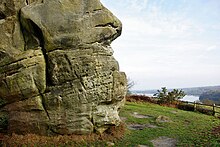
since 2001, who run it for the benefit of climbers. There are 74 identified climbs on the rocks. Bolt belays have been installed at the top of many of the climbs to reduce erosion of the site.
357:
822:
348:
297:
56:
558:
106:
24:
832:
378:
341:
136:
between 140 and 100 million years ago. It displays a variety of sedimentary structures in three dimensions and is described by
786:
681:
628:
403:
144:
125:
118:
761:
140:
as "an important site for the study and interpretation of sedimentary structures in the upper Lower
Tunbridge Wells Sand".
32:
837:
598:
653:
473:
468:
453:
603:
771:
608:
334:
528:
247:
827:
618:
643:
721:
326:
686:
383:
756:
478:
443:
766:
711:
706:
503:
463:
438:
225:
796:
781:
751:
716:
613:
578:
428:
418:
198:
80:
648:
593:
573:
538:
423:
388:
133:
741:
736:
731:
696:
638:
488:
413:
211:
137:
746:
658:
633:
568:
523:
483:
458:
272:
110:
50:
811:
513:
508:
448:
433:
129:
791:
726:
701:
663:
533:
398:
373:
193:"Map of Stone Hill Rocks". Sites of Special Scientific Interest. Natural England.
691:
583:
553:
518:
498:
493:
408:
114:
673:
623:
588:
543:
393:
365:
312:
299:
563:
548:
124:
This is typical of many sandstone crags in mid-Sussex which expose the
228:. Geological Conservation Review. Joint Nature Conservation Committee
330:
253:. Sites of Special Scientific Interest. Natural England
174:. Sites of Special Scientific Interest. Natural England
818:
Sites of
Special Scientific Interest in West Sussex
672:
364:
358:
Sites of
Special Scientific Interest in West Sussex
89:
79:
71:
63:
49:
39:
342:
8:
18:
349:
335:
327:
31:
17:
172:"Designated Sites View: Stone Hill Rocks"
156:
105:is a 0.6-hectare (1.5-acre) geological
207:
196:
166:
164:
162:
160:
7:
823:Geological Conservation Review sites
559:Northpark Copse to Snapelands Copse
107:Site of Special Scientific Interest
25:Site of Special Scientific Interest
14:
379:Amberley Mount to Sullington Hill
143:The site has been owned by the
787:Wakehurst and Chiddingly Woods
682:Beeding Hill to Newtimber Hill
629:Wakehurst and Chiddingly Woods
404:Beeding Hill to Newtimber Hill
145:British Mountaineering Council
126:Tunbridge Wells Sand Formation
119:Geological Conservation Review
1:
599:Singleton and Cocking Tunnels
654:Woolbeding and Pound Commons
474:Duncton to Bignor Escarpment
454:Clayton to Offham Escarpment
277:BMC Regional Access Database
762:Philpot's and Hook Quarries
248:"Stone Hill Rocks citation"
854:
772:Slinfold Stream and Quarry
226:"East Grinstead (Wealden)"
833:Climbing areas of England
469:Cow Wood and Harry's Wood
30:
23:
75:0.6 hectares (1.5 acres)
619:Treyford to Bepton Down
609:St Leonard's Park Ponds
722:Eartham Pit, Boxgrove
838:Sport in West Sussex
687:Bognor Common Quarry
384:Amberley Wild Brooks
757:Perry Copse Outcrop
604:St Leonard's Forest
479:East Dean Park Wood
444:Chiddingfold Forest
309: /
132:which dates to the
20:
767:Selsey, East Beach
712:Coneyhurst Cutting
707:Chichester Harbour
504:Halnaker Chalk Pit
439:Chichester Harbour
273:"Stone Farm Rocks"
805:
804:
752:Park Farm Cutting
717:Coppedhall Hanger
644:West Harting Down
614:Sullington Warren
579:Pulborough Brooks
429:Chanctonbury Hill
419:Buchan Hill Ponds
206:Missing or empty
96:
95:
845:
777:Stone Hill Rocks
649:Wolstonbury Hill
594:Shillinglee Lake
539:Lavington Common
389:Ambersham Common
351:
344:
337:
328:
324:
323:
321:
320:
319:
314:
313:51.095°N 0.031°W
310:
307:
306:
305:
302:
289:
288:
286:
284:
269:
263:
262:
260:
258:
252:
244:
238:
237:
235:
233:
222:
216:
215:
209:
204:
202:
194:
190:
184:
183:
181:
179:
168:
134:Early Cretaceous
103:Stone Hill Rocks
99:Stone Farm Rocks
59:
35:
21:
19:Stone Hill Rocks
853:
852:
848:
847:
846:
844:
843:
842:
808:
807:
806:
801:
742:Marehill Quarry
737:Horton Clay Pit
732:Freshfield Lane
697:Bracklesham Bay
668:
639:West Dean Woods
489:Fairmile Bottom
414:Bracklesham Bay
360:
355:
317:
315:
311:
308:
303:
300:
298:
296:
295:
293:
292:
282:
280:
271:
270:
266:
256:
254:
250:
246:
245:
241:
231:
229:
224:
223:
219:
205:
195:
192:
191:
187:
177:
175:
170:
169:
158:
153:
138:Natural England
55:
12:
11:
5:
851:
849:
841:
840:
835:
830:
828:East Grinstead
825:
820:
810:
809:
803:
802:
800:
799:
794:
789:
784:
779:
774:
769:
764:
759:
754:
749:
747:Pagham Harbour
744:
739:
734:
729:
724:
719:
714:
709:
704:
699:
694:
689:
684:
678:
676:
670:
669:
667:
666:
661:
659:Woolmer Forest
656:
651:
646:
641:
636:
634:Waltham Brooks
631:
626:
621:
616:
611:
606:
601:
596:
591:
586:
581:
576:
571:
569:Pagham Harbour
566:
561:
556:
551:
546:
541:
536:
531:
526:
524:Hurston Warren
521:
516:
511:
506:
501:
496:
491:
486:
484:Ebernoe Common
481:
476:
471:
466:
461:
459:Climping Beach
456:
451:
446:
441:
436:
431:
426:
421:
416:
411:
406:
401:
396:
391:
386:
381:
376:
370:
368:
362:
361:
356:
354:
353:
346:
339:
331:
318:51.095; -0.031
291:
290:
264:
239:
217:
185:
155:
154:
152:
149:
128:, part of the
111:East Grinstead
94:
93:
91:
87:
86:
83:
77:
76:
73:
69:
68:
65:
61:
60:
53:
51:Grid reference
47:
46:
43:
37:
36:
28:
27:
13:
10:
9:
6:
4:
3:
2:
850:
839:
836:
834:
831:
829:
826:
824:
821:
819:
816:
815:
813:
798:
795:
793:
790:
788:
785:
783:
780:
778:
775:
773:
770:
768:
765:
763:
760:
758:
755:
753:
750:
748:
745:
743:
740:
738:
735:
733:
730:
728:
725:
723:
720:
718:
715:
713:
710:
708:
705:
703:
700:
698:
695:
693:
690:
688:
685:
683:
680:
679:
677:
675:
671:
665:
662:
660:
657:
655:
652:
650:
647:
645:
642:
640:
637:
635:
632:
630:
627:
625:
622:
620:
617:
615:
612:
610:
607:
605:
602:
600:
597:
595:
592:
590:
587:
585:
582:
580:
577:
575:
572:
570:
567:
565:
562:
560:
557:
555:
552:
550:
547:
545:
542:
540:
537:
535:
532:
530:
527:
525:
522:
520:
517:
515:
514:Heyshott Down
512:
510:
509:Harting Downs
507:
505:
502:
500:
497:
495:
492:
490:
487:
485:
482:
480:
477:
475:
472:
470:
467:
465:
464:Coates Castle
462:
460:
457:
455:
452:
450:
449:Cissbury Ring
447:
445:
442:
440:
437:
435:
434:Chapel Common
432:
430:
427:
425:
422:
420:
417:
415:
412:
410:
407:
405:
402:
400:
397:
395:
392:
390:
387:
385:
382:
380:
377:
375:
372:
371:
369:
367:
363:
359:
352:
347:
345:
340:
338:
333:
332:
329:
325:
322:
278:
274:
268:
265:
249:
243:
240:
227:
221:
218:
213:
200:
189:
186:
173:
167:
165:
163:
161:
157:
150:
148:
146:
141:
139:
135:
131:
130:Wealden Group
127:
122:
120:
116:
112:
108:
104:
100:
92:
88:
84:
82:
78:
74:
70:
66:
62:
58:
54:
52:
48:
44:
42:
38:
34:
29:
26:
22:
16:
797:West Hoathly
782:Turners Hill
776:
702:Chantry Mill
664:Worth Forest
534:Kingley Vale
529:Iping Common
399:Arundel Park
374:Adur Estuary
294:
281:. Retrieved
276:
267:
255:. Retrieved
242:
230:. Retrieved
220:
188:
176:. Retrieved
142:
123:
102:
98:
97:
90:Location map
81:Notification
15:
692:Bognor Reef
584:Rake Hanger
574:Parham Park
554:Mills Rocks
519:House Copse
499:Fyning Moor
494:Forest Mere
424:Burton Park
409:Bognor Reef
316: /
115:West Sussex
45:West Sussex
812:Categories
674:Geological
624:Upper Arun
589:Rook Clift
544:Levin Down
394:Arun Banks
366:Biological
301:51°05′42″N
208:|url=
151:References
117:. It is a
67:Geological
57:TQ 380 347
564:Pads Wood
304:0°01′52″W
232:9 January
109:south of
549:The Mens
199:cite web
64:Interest
41:Location
792:Warnham
727:Felpham
257:17 May
178:17 May
121:site.
283:1 May
279:. BMC
251:(PDF)
285:2011
259:2019
234:2019
212:help
180:2019
85:1990
72:Area
113:in
101:or
814::
275:.
203::
201:}}
197:{{
159:^
350:e
343:t
336:v
287:.
261:.
236:.
214:)
210:(
182:.
Text is available under the Creative Commons Attribution-ShareAlike License. Additional terms may apply.