58:
766:
42:
80:
168:
463:. The investors intended to develop the land for tourism and sought the immediate eviction of the settlers. A large group of settlers, mostly Hispanics, gathered to protest and surrounded a hotel in Stonewall where the company's employees barricaded themselves. A gunfight ensued in which three of the protesters were shot and killed. In the aftermath several of the protesters were arrested and later convicted of inciting a riot.
505:
188:
87:
459:, who had settled on lands in the grant. The Stonewall incident in 1888 was the most violent of many incidents in the dispute between the Maxwell Company and the settlers on grant lands. The company had sold 5,000 acres (2,000 ha) of grant land in Colorado to a group of investors including Colorado governor,
57:
450:
awarded by the government of New Mexico to two
Mexican citizens in 1841. The grant area was later owned by foreign investors who created the Maxwell Land Grant Company and attempted to expel the farmers, ranchers, and miners, both
1049:
119:
704:
470:
affirmed the ownership of the grant land by the foreign investors and by 1899 most of the original settlers had either been evicted or had come to terms with the company.
1054:
697:
415:
through the 8,400 feet (2,600 meters) elevation
Stonewall Ridge. Highway 12 leads east down the Purgatoire River valley 33 miles (53 km) to
41:
79:
690:
350:
966:
467:
641:
557:
682:
200:
714:
561:
518:
479:
373:
205:
64:
428:
586:
488:
408:
385:
47:
338:
160:
542:
1019:
815:
369:
32:
315:
294:
460:
634:
Translating property: the
Maxwell Land Grant and the conflict over land in the American West, 1840-1900
1026:
933:
805:
304:
923:
868:
365:
220:
971:
913:
883:
795:
755:
736:
447:
416:
996:
976:
961:
956:
898:
843:
823:
790:
785:
637:
432:
1006:
1001:
991:
986:
981:
951:
928:
918:
878:
858:
853:
833:
828:
412:
389:
329:
908:
903:
888:
510:
893:
838:
1043:
800:
424:
381:
343:
173:
103:
672:
543:
U.S. Geological Survey
Geographic Names Information System: Stonewall Gap, Colorado
636:. Berkeley, California: University of California Press. pp. 155–156, 91–202.
558:"State of Colorado Census Designated Places - BAS20 - Data as of January 1, 2020"
446:
The
Stonewall area was originally part of the 1,714,765 acres (6,939.41 km)
729:
420:
392:
943:
500:
180:
135:
121:
438:
The
Stonewall Gap CDP has an area of 1,229 acres (4.974 km), all land.
285:
456:
396:
377:
323:
193:
677:
765:
610:
452:
311:
290:
777:
747:
686:
764:
384:. The population of the Stonewall Gap CDP was 66 at the
1050:
Census-designated places in Las Animas County, Colorado
942:
867:
814:
776:
746:
349:
337:
322:
301:
284:
276:
268:
263:
255:
247:
239:
231:
226:
216:
211:
199:
179:
159:
23:
18:Census Designated Place in Colorado, United States
769:Map of Colorado highlighting Las Animas County
493:The population was 67 in 2010 and 66 in 2020.
698:
580:
578:
552:
550:
8:
705:
691:
683:
411:at a gap formed by the Middle Fork of the
20:
605:
603:
101:Location of the Stonewall Gap CDP in the
656:
530:
348:
321:
283:
262:
254:
225:
210:
158:
114:
72:
54:
38:
538:
536:
534:
336:
300:
275:
267:
251:0.000 sq mi (0.000 km)
246:
243:1.920 sq mi (4.974 km)
238:
235:1.920 sq mi (4.974 km)
230:
215:
198:
178:
86:
62:Location of the Stonewall Gap CDP in
7:
1055:Census-designated places in Colorado
713:Municipalities and communities of
468:Supreme Court of the United States
14:
611:"Zip Code 81091 Map and Profile"
503:
364:(also known as Stonewall) is an
186:
166:
85:
78:
56:
40:
673:Stonewall @ UncoverColorado.com
1:
587:"Stonewall Gap CDP, Colorado"
585:United States Census Bureau.
370:census-designated place (CDP)
659:, pp. 155–156, 191–202.
259:7,976 ft (2,431 m)
716:Las Animas County, Colorado
562:United States Census Bureau
519:Las Animas County, Colorado
480:United States Census Bureau
372:located in and governed by
147:Stonewall Gap CDP, Colorado
65:Las Animas County, Colorado
1071:
632:Montoya, Maria E. (2002).
429:Sangre de Cristo Mountains
1015:
762:
727:
678:Las Animas County website
489:United States Census 2010
431:32 miles (51 km) to
409:Colorado State Highway 12
407:Stonewall Gap lies along
386:United States Census 2020
115:
73:
55:
48:Colorado State Highway 12
39:
30:
399:81091) serves the area.
366:unincorporated community
221:unincorporated community
613:. zipdatamaps.com. 2020
33:Census Designated Place
25:Stonewall Gap, Colorado
770:
482:initially defined the
136:37.16056°N 105.03417°W
768:
303: • Summer (
280:34/sq mi (13/km)
1028:United States portal
277: • Density
141:37.16056; -105.03417
131: /
771:
448:Maxwell Land Grant
269: • Total
248: • Water
232: • Total
46:Stonewall Gap and
1037:
1036:
484:Stonewall Gap CDP
423:, and north over
419:, the Las Animas
374:Las Animas County
359:
358:
240: • Land
217: • Type
206:Las Animas County
1062:
1029:
1022:
767:
739:
732:
722:
717:
707:
700:
693:
684:
660:
654:
648:
647:
629:
623:
622:
620:
618:
607:
598:
597:
595:
593:
582:
573:
572:
570:
568:
554:
545:
540:
513:
508:
507:
506:
492:
485:
413:Purgatoire River
308:
192:
190:
189:
172:
170:
169:
155:
154:
152:
151:
150:
148:
143:
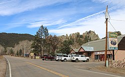
142:
137:
132:
129:
128:
127:
124:
107:
95:
89:
88:
82:
68:
60:
44:
21:
1070:
1069:
1065:
1064:
1063:
1061:
1060:
1059:
1040:
1039:
1038:
1033:
1027:
1021:Colorado portal
1020:
1011:
938:
870:
863:
810:
772:
760:
742:
737:
730:
723:
720:
715:
711:
669:
664:
663:
655:
651:
644:
631:
630:
626:
616:
614:
609:
608:
601:
591:
589:
584:
583:
576:
566:
564:
556:
555:
548:
541:
532:
527:
511:Colorado portal
509:
504:
502:
499:
487:
483:
476:
444:
405:
351:GNIS feature ID
333:
302:
187:
185:
167:
165:
146:
144:
140:
138:
134:
133:
130:
125:
122:
120:
118:
117:
111:
110:
109:
108:
102:
99:
98:
97:
96:
93:
90:
69:
63:
51:
35:
26:
19:
12:
11:
5:
1068:
1066:
1058:
1057:
1052:
1042:
1041:
1035:
1034:
1032:
1031:
1024:
1016:
1013:
1012:
1010:
1009:
1004:
999:
994:
989:
984:
979:
974:
969:
964:
959:
954:
948:
946:
940:
939:
937:
936:
931:
926:
921:
916:
911:
906:
901:
896:
891:
886:
881:
875:
873:
869:Unincorporated
865:
864:
862:
861:
856:
851:
846:
841:
836:
831:
826:
820:
818:
812:
811:
809:
808:
803:
798:
793:
788:
782:
780:
774:
773:
763:
761:
759:
758:
752:
750:
744:
743:
728:
725:
724:
712:
710:
709:
702:
695:
687:
681:
680:
675:
668:
667:External links
665:
662:
661:
649:
642:
624:
599:
574:
546:
529:
528:
526:
523:
522:
521:
515:
514:
498:
495:
475:
472:
443:
440:
404:
401:
357:
356:
353:
347:
346:
341:
335:
334:
328:
326:
320:
319:
309:
299:
298:
288:
282:
281:
278:
274:
273:
270:
266:
265:
261:
260:
257:
253:
252:
249:
245:
244:
241:
237:
236:
233:
229:
228:
224:
223:
218:
214:
213:
209:
208:
203:
197:
196:
183:
177:
176:
163:
157:
156:
113:
112:
100:
92:
91:
84:
83:
77:
76:
75:
74:
71:
70:
61:
53:
52:
45:
37:
36:
31:
28:
27:
24:
17:
13:
10:
9:
6:
4:
3:
2:
1067:
1056:
1053:
1051:
1048:
1047:
1045:
1030:
1025:
1023:
1018:
1017:
1014:
1008:
1005:
1003:
1000:
998:
995:
993:
990:
988:
985:
983:
980:
978:
975:
973:
970:
968:
965:
963:
960:
958:
955:
953:
950:
949:
947:
945:
941:
935:
932:
930:
927:
925:
922:
920:
917:
915:
912:
910:
907:
905:
902:
900:
897:
895:
892:
890:
887:
885:
882:
880:
877:
876:
874:
872:
866:
860:
857:
855:
852:
850:
849:Stonewall Gap
847:
845:
842:
840:
837:
835:
832:
830:
827:
825:
822:
821:
819:
817:
813:
807:
804:
802:
799:
797:
794:
792:
789:
787:
784:
783:
781:
779:
775:
757:
754:
753:
751:
749:
745:
741:
740:
733:
726:
721:United States
718:
708:
703:
701:
696:
694:
689:
688:
685:
679:
676:
674:
671:
670:
666:
658:
653:
650:
645:
643:0-520-22744-1
639:
635:
628:
625:
612:
606:
604:
600:
588:
581:
579:
575:
563:
559:
553:
551:
547:
544:
539:
537:
535:
531:
524:
520:
517:
516:
512:
501:
496:
494:
490:
481:
473:
471:
469:
464:
462:
458:
454:
449:
441:
439:
436:
434:
430:
426:
425:Cucharas Pass
422:
418:
414:
410:
402:
400:
398:
394:
391:
387:
383:
382:United States
379:
375:
371:
367:
363:
362:Stonewall Gap
354:
352:
345:
342:
340:
331:
327:
325:
317:
313:
310:
306:
296:
292:
289:
287:
279:
271:
258:
250:
242:
234:
222:
219:
207:
204:
202:
195:
184:
182:
175:
174:United States
164:
162:
153:
116:Coordinates:
105:
104:United States
94:Stonewall Gap
81:
66:
59:
49:
43:
34:
29:
22:
16:
848:
735:
657:Montoya 2002
652:
633:
627:
617:December 23,
615:. Retrieved
590:. Retrieved
565:. Retrieved
477:
474:Demographics
465:
445:
437:
406:
361:
360:
15:
944:Ghost towns
871:communities
731:County seat
567:November 3,
421:county seat
393:post office
139: /
126:105°02′03″W
1044:Categories
934:Villegreen
806:Starkville
525:References
461:Alva Adams
264:Population
212:Government
145: (
123:37°09′38″N
924:Trinchera
592:April 14,
457:Hispanics
403:Geography
339:Area code
286:Time zone
256:Elevation
972:Brodhead
914:Thatcher
884:Boncarbo
796:Cokedale
756:Trinidad
738:Trinidad
497:See also
486:for the
417:Trinidad
397:Zip Code
378:Colorado
324:ZIP Code
194:Colorado
997:Primero
977:Delagua
962:Beshoar
957:Berwind
899:Gulnare
844:Segundo
824:El Moro
791:Branson
786:Aguilar
442:History
433:La Veta
427:in the
355:2583300
161:Country
1007:Tercio
1002:Sopris
992:Morley
987:Madrid
982:Ludlow
952:Abeyta
929:Tyrone
919:Torres
879:Barela
859:Weston
854:Valdez
834:Jansen
829:Hoehne
640:
453:Anglos
390:Weston
388:. The
368:and a
330:Weston
201:County
191:
171:
967:Bowen
909:Rugby
904:Model
889:Delhi
778:Towns
332:81091
312:UTC-6
291:UTC-7
181:State
894:Earl
839:Lynn
816:CDPs
748:City
638:ISBN
619:2020
594:2023
569:2021
478:The
466:The
455:and
227:Area
801:Kim
344:719
316:MDT
305:DST
295:MST
1046::
734::
719:,
602:^
577:^
560:.
549:^
533:^
435:.
380:,
376:,
272:66
706:e
699:t
692:v
646:.
621:.
596:.
571:.
491:.
395:(
318:)
314:(
307:)
297:)
293:(
149:)
106:.
67:.
50:.
Text is available under the Creative Commons Attribution-ShareAlike License. Additional terms may apply.