38:
45:
228:, separated by the Goulburn and Broken River valleys. This separation has produced unique biogeographic and ecological patterns. Some of the more prominent peaks of the range include Mount Strathbogie (1,033 metres (3,389 ft)), Mount Wombat (791 metres (2,595 ft)), Sugarloaf (691 metres (2,267 ft)) and Mount Barranhet (832 metres (2,730 ft)).
280:
The
Strathbogie wine region developed from the mid 1970s with Dr Peter Tisdall planting a new vineyard at Mt Helen. There are over 25 vineyards located in the region, at altitudes ranging from 150–650 metres (490–2,130 ft), with plantings on acidic sandy loams formed from decomposed granite. The
240:
country. Although the documented white history of the area generally asserts that the mountain range was not often frequented by indigenous people, stone artifacts are widely distributed across the
Strathbogie Tableland, all of which was once forested. The discovery of these artifacts is evidence of
223:
The range is the remains of a granite uplifted plateau in the southern part of the ranges and volcanic eruption in the north which formed a 20–30-kilometre (12–19 mi) wide cauldron volcano. The topography consists of a series of ridges dissected by streams. The
Strathbogie Ranges are north of
244:
Squatters running sheep and hundreds of cattle took up large tracts of land in the Ranges from about 1842. The stations included Bailey Hill, Strathbogie, Springs A and Wombat Hill, predominantly in the hill country, while parts of
Saintfield and Borodomanin were also in the ranges. John Gall of
245:
Wombat Hill was one of the few early settlers to remain in the district. John
Kissock of Strathbogie Station arrived in the 1847, while William Forlonge later owned Strathbogie totalling 75,000 hectares (185,000 acres), and many of the other pastoral stations, between the early 1850s and 1867.
271:
prior to
European settlement. Several bushfires of restricted extent have burnt parts of the ranges in recent years Strathbogie 1990 and Longwood East-Creighton's Creek 2014 The major bushfires of 1851, 1939, 1983, 2003, 2006 and 2009 did not reach the Strathbogie Ranges.
248:
In 1891 a butter factory was built at
Strathbogie South (as Strathbogie was then known and a second factory was built in 1892 at Strathbogie North. A Post Office opened in Strathbogie on 10 July 1878.
464:
37:
121:
207:, rising to 1,033 metres (3,389 ft) at Mount Strathbogie. The Strathbogie Ranges are located approximately 150 kilometres (93 mi) north-east of
824:
383:
419:
920:
457:
335:
1126:
267:
Due to the climate of the region, the type of vegetation and the topography, the
Strathbogie Ranges likely experienced periodic
473:
1366:
975:
450:
114:
347:
816:
490:
1110:
1005:
596:
432:
259:, but no towns and few major roads; Strathbogie township has a general store and Ruffy township has 'The Pantry'.
1326:
1183:
904:
1319:
951:
864:
800:
715:
605:
311:
896:
760:
566:
481:
1166:
840:
508:
268:
252:
1207:
691:
297:
1215:
1199:
1191:
225:
212:
204:
160:
107:
58:
1094:
1086:
1134:
1069:
1017:
707:
550:
172:
1239:
1118:
768:
529:
182:
1287:
1042:
928:
912:
1303:
1175:
996:
856:
744:
1223:
1158:
1150:
256:
1279:
1247:
848:
784:
650:
641:
520:
200:
153:
1360:
1078:
984:
936:
832:
808:
699:
682:
301:, Flora, fauna & natural history of the Strathbogie Ranges, Victoria, Australia.
1311:
1271:
1231:
1142:
944:
880:
792:
735:
558:
442:
241:
regular, though perhaps seasonal, utilization of the region by indigenous people.
1263:
888:
872:
776:
407:
370:
1340:
1333:
1102:
752:
323:
237:
136:
123:
1255:
281:
main wine varieties are
Chardonnay, Sauvignon Blanc, Pinot Noir and Shiraz.
251:
There are several districts located within the
Strathbogie Ranges including
208:
1295:
187:
420:
Victorian fires: Homes destroyed by Creightons Creek, Lake Rowan fires
359:
446:
360:
Strathbogie Tableland, community web portal, 'History'
1060:
1041:
1016:
995:
974:
965:
726:
681:
640:
595:
528:
519:
480:
181:
171:
166:
152:
113:
103:
95:
90:
82:
74:
69:
20:
458:
8:
312:Taungurung Registered Aboriginal Party – Map
971:
525:
465:
451:
443:
371:Victoria Places, Stratbogie Butter Factory
44:
17:
403:
401:
290:
336:Stone artefacts – Srathbogie district.
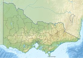
236:The Strathbogie Ranges are located in
57:Location of the Strathbogie Ranges in
314:Taungurung Lands & Water Council)
7:
14:
474:Mountains in Victoria, Australia
299:Strathbogie Ranges – Nature View
86:10 km (6.2 mi) E-W
43:
36:
1098:(1,130 m or 3,707 ft)
1090:(1,247 m or 4,091 ft)
1082:(1,259 m or 4,131 ft)
1074:(1,377 m or 4,518 ft)
988:(1,001 m or 3,284 ft)
924:(1,153 m or 3,783 ft)
916:(1,250 m or 4,101 ft)
908:(1,325 m or 4,347 ft)
900:(1,411 m or 4,629 ft)
892:(1,430 m or 4,692 ft)
884:(1,435 m or 4,708 ft)
876:(1,456 m or 4,777 ft)
868:(1,460 m or 4,790 ft)
860:(1,509 m or 4,951 ft)
852:(1,516 m or 4,974 ft)
844:(1,567 m or 5,141 ft)
836:(1,567 m or 5,141 ft)
828:(1,598 m or 5,243 ft)
820:(1,634 m or 5,361 ft)
812:(1,723 m or 5,653 ft)
804:(1,723 m or 5,653 ft)
796:(1,742 m or 5,715 ft)
788:(1,749 m or 5,738 ft)
780:(1,750 m or 5,741 ft)
772:(1,755 m or 5,758 ft)
764:(1,805 m or 5,922 ft)
756:(1,865 m or 6,119 ft)
748:(1,922 m or 6,306 ft)
740:(1,986 m or 6,516 ft)
719:(1,460 m or 4,790 ft)
711:(1,545 m or 5,069 ft)
703:(1,628 m or 5,341 ft)
695:(1,648 m or 5,407 ft)
654:(1,810 m or 5,938 ft)
615:(1,241 m or 4,072 ft)
609:(1,482 m or 4,862 ft)
588:(1,818 m or 5,965 ft)
582:(1,837 m or 6,027 ft)
576:(1,837 m or 6,027 ft)
570:(1,849 m or 6,066 ft)
562:(1,862 m or 6,109 ft)
554:(1,883 m or 6,178 ft)
546:(1,885 m or 6,184 ft)
540:(1,893 m or 6,211 ft)
494:(1,167 m or 3,829 ft)
324:Strathbogie Centenary 1877-1977
78:50 km (31 mi) N-S
1:
1275:(310 m or 1,017 ft)
1267:(313 m or 1,027 ft)
1259:(352 m or 1,155 ft)
1251:(369 m or 1,211 ft)
1243:(420 m or 1,378 ft)
1235:(440 m or 1,444 ft)
1227:(444 m or 1,457 ft)
1219:(526 m or 1,726 ft)
1211:(556 m or 1,824 ft)
1203:(628 m or 2,060 ft)
1195:(634 m or 2,080 ft)
1187:(648 m or 2,126 ft)
1179:(714 m or 2,343 ft)
1171:(718 m or 2,356 ft)
1162:(719 m or 2,359 ft)
1154:(744 m or 2,441 ft)
1146:(745 m or 2,444 ft)
1138:(781 m or 2,562 ft)
1130:(794 m or 2,605 ft)
1122:(924 m or 3,031 ft)
1114:(941 m or 3,087 ft)
1106:(998 m or 3,274 ft)
1053:(740 m or 2,428 ft)
1034:(537 m or 1,762 ft)
1028:(747 m or 2,451 ft)
1009:(633 m or 2,077 ft)
940:(740 m or 2,428 ft)
932:(906 m or 2,972 ft)
633:(761 m or 2,497 ft)
627:(801 m or 2,628 ft)
621:(904 m or 2,966 ft)
512:(364 m or 1,194 ft)
435:. Wine Australia Corporation.
326:National Library of Australia
1315:(137 m or 449 ft)
1307:(148 m or 486 ft)
1299:(178 m or 584 ft)
1291:(216 m or 709 ft)
1283:(240 m or 787 ft)
1383:
382:Phoenix Auctions History,
433:"Strathbogie Wine Region"
422:ABC News 17 December 2014
30:
25:
348:Mt Spy aka Major’s Hill.
188:Strathbogie Granodiorite
410:Country Fire Authority
26:Strathbogie Tableland
1367:Great Dividing Range
921:Buggery (Wangaratta)
226:Great Dividing Range
205:Great Dividing Range
161:Great Dividing Range
350:Strathbogies Ranges
338:Strathbogies Ranges
219:Geology and ecology
133: /
631:South Jawbone Peak
530:Bogong High Plains
197:Strathbogie Ranges
137:36.847°S 145.387°E
51:Strathbogie Ranges
21:Strathbogie Ranges
1354:
1353:
1350:
1349:
1043:Strzelecki Ranges
976:Central Highlands
961:
960:
199:are a set of low
193:
192:
115:Range coordinates
1374:
997:Dandenong Ranges
972:
825:Buggery (Alpine)
526:
467:
460:
453:
444:
437:
436:
429:
423:
417:
411:
405:
396:
395:
394:
392:
385:Post Office List
379:
373:
368:
362:
357:
351:
345:
339:
333:
327:
321:
315:
309:
303:
295:
156:
148:
147:
145:
144:
143:
142:-36.847; 145.387
138:
134:
131:
130:
129:
126:
47:
46:
40:
18:
1382:
1381:
1377:
1376:
1375:
1373:
1372:
1371:
1357:
1356:
1355:
1346:
1056:
1037:
1018:Pyrenees Ranges
1012:
991:
968:mountain ranges
967:
957:
722:
683:Cobbler Plateau
677:
636:
597:Cathedral Range
591:
515:
476:
471:
441:
440:
431:
430:
426:
418:
414:
406:
399:
390:
388:
381:
380:
376:
369:
365:
358:
354:
346:
342:
334:
330:
322:
318:
310:
306:
296:
292:
287:
278:
265:
234:
221:
201:mountain ranges
154:
141:
139:
135:
132:
127:
124:
122:
120:
119:
65:
64:
63:
62:
61:
55:
54:
53:
52:
48:
12:
11:
5:
1380:
1378:
1370:
1369:
1359:
1358:
1352:
1351:
1348:
1347:
1345:
1344:
1337:
1330:
1323:
1316:
1308:
1300:
1292:
1284:
1276:
1268:
1260:
1252:
1244:
1236:
1228:
1220:
1212:
1204:
1200:Corhanwarrabul
1196:
1188:
1180:
1172:
1163:
1155:
1147:
1139:
1131:
1127:Disappointment
1123:
1115:
1107:
1099:
1091:
1083:
1075:
1064:
1062:
1058:
1057:
1055:
1054:
1047:
1045:
1039:
1038:
1036:
1035:
1029:
1022:
1020:
1014:
1013:
1011:
1010:
1001:
999:
993:
992:
990:
989:
980:
978:
969:
963:
962:
959:
958:
956:
955:
948:
941:
933:
925:
917:
909:
901:
893:
885:
877:
869:
861:
853:
845:
841:Saint Phillack
837:
829:
821:
813:
805:
797:
789:
781:
773:
765:
757:
749:
741:
730:
728:
724:
723:
721:
720:
712:
704:
696:
687:
685:
679:
678:
676:
675:
670:
665:
660:
658:Cobberas No. 2
655:
651:Cobberas No. 1
646:
644:
642:Cobberas Range
638:
637:
635:
634:
628:
622:
616:
613:The Green Hill
610:
601:
599:
593:
592:
590:
589:
583:
577:
571:
563:
555:
547:
541:
534:
532:
523:
521:Victorian Alps
517:
516:
514:
513:
505:
500:
495:
486:
484:
478:
477:
472:
470:
469:
462:
455:
447:
439:
438:
424:
412:
397:
374:
363:
352:
340:
328:
316:
304:
289:
288:
286:
283:
277:
274:
264:
261:
233:
230:
220:
217:
191:
190:
185:
179:
178:
175:
169:
168:
164:
163:
158:
150:
149:
117:
111:
110:
105:
101:
100:
97:
93:
92:
88:
87:
84:
80:
79:
76:
72:
71:
67:
66:
56:
50:
49:
42:
41:
35:
34:
33:
32:
31:
28:
27:
23:
22:
13:
10:
9:
6:
4:
3:
2:
1379:
1368:
1365:
1364:
1362:
1343:
1342:
1338:
1336:
1335:
1331:
1329:
1328:
1324:
1322:
1321:
1317:
1314:
1313:
1309:
1306:
1305:
1301:
1298:
1297:
1293:
1290:
1289:
1285:
1282:
1281:
1277:
1274:
1273:
1269:
1266:
1265:
1261:
1258:
1257:
1253:
1250:
1249:
1245:
1242:
1241:
1237:
1234:
1233:
1229:
1226:
1225:
1221:
1218:
1217:
1213:
1210:
1209:
1205:
1202:
1201:
1197:
1194:
1193:
1189:
1186:
1185:
1181:
1178:
1177:
1173:
1170:
1168:
1164:
1161:
1160:
1156:
1153:
1152:
1148:
1145:
1144:
1140:
1137:
1136:
1132:
1129:
1128:
1124:
1121:
1120:
1116:
1113:
1112:
1108:
1105:
1104:
1100:
1097:
1096:
1092:
1089:
1088:
1084:
1081:
1080:
1076:
1073:
1072:
1071:
1066:
1065:
1063:
1059:
1052:
1049:
1048:
1046:
1044:
1040:
1033:
1030:
1027:
1024:
1023:
1021:
1019:
1015:
1008:
1007:
1003:
1002:
1000:
998:
994:
987:
986:
982:
981:
979:
977:
973:
970:
964:
954:
953:
949:
947:
946:
942:
939:
938:
934:
931:
930:
926:
923:
922:
918:
915:
914:
910:
907:
906:
902:
899:
898:
894:
891:
890:
886:
883:
882:
878:
875:
874:
870:
867:
866:
862:
859:
858:
854:
851:
850:
846:
843:
842:
838:
835:
834:
830:
827:
826:
822:
819:
818:
814:
811:
810:
806:
803:
802:
798:
795:
794:
790:
787:
786:
782:
779:
778:
774:
771:
770:
766:
763:
762:
758:
755:
754:
750:
747:
746:
742:
739:
738:
737:
732:
731:
729:
725:
718:
717:
713:
710:
709:
705:
702:
701:
697:
694:
693:
689:
688:
686:
684:
680:
674:
671:
669:
666:
664:
661:
659:
656:
653:
652:
648:
647:
645:
643:
639:
632:
629:
626:
625:The Cathedral
623:
620:
617:
614:
611:
608:
607:
603:
602:
600:
598:
594:
587:
584:
581:
578:
575:
572:
569:
568:
564:
561:
560:
556:
553:
552:
551:Fainter South
548:
545:
542:
539:
536:
535:
533:
531:
527:
524:
522:
518:
511:
510:
506:
504:
501:
499:
496:
493:
492:
488:
487:
485:
483:
479:
475:
468:
463:
461:
456:
454:
449:
448:
445:
434:
428:
425:
421:
416:
413:
409:
404:
402:
398:
387:
386:
378:
375:
372:
367:
364:
361:
356:
353:
349:
344:
341:
337:
332:
329:
325:
320:
317:
313:
308:
305:
302:
300:
294:
291:
284:
282:
275:
273:
270:
262:
260:
258:
254:
249:
246:
242:
239:
231:
229:
227:
218:
216:
214:
210:
206:
202:
198:
189:
186:
184:
180:
176:
174:
170:
165:
162:
159:
157:
151:
146:
118:
116:
112:
109:
106:
102:
98:
94:
89:
85:
81:
77:
73:
68:
60:
39:
29:
24:
19:
16:
1339:
1332:
1325:
1318:
1310:
1302:
1294:
1286:
1278:
1270:
1262:
1254:
1246:
1240:Briggs Bluff
1238:
1230:
1222:
1214:
1206:
1198:
1190:
1182:
1174:
1167:Hanging Rock
1165:
1157:
1149:
1141:
1133:
1125:
1117:
1109:
1101:
1093:
1085:
1077:
1068:
1067:
1050:
1031:
1025:
1004:
983:
950:
945:Brumby Point
943:
935:
927:
919:
911:
903:
895:
887:
879:
871:
863:
855:
847:
839:
831:
823:
815:
807:
799:
791:
783:
775:
767:
759:
751:
743:
734:
733:
714:
706:
698:
690:
672:
667:
662:
657:
649:
630:
624:
618:
612:
604:
585:
579:
573:
565:
557:
549:
543:
537:
507:
502:
497:
489:
427:
415:
389:, retrieved
384:
377:
366:
355:
343:
331:
319:
307:
298:
293:
279:
266:
250:
247:
243:
235:
222:
196:
194:
183:Type of rock
155:Parent range
15:
1288:Warrnambool
1208:Tarrengower
929:Bulla Bulla
913:Donna Buang
692:Speculation
668:Middle Peak
663:Moscow Peak
580:Spion Kopje
544:Nelse North
408:Major Fires
276:Wine region
253:Strathbogie
203:within the
173:Age of rock
140: /
128:145°23′13″E
1341:Jack Hills
1304:Wycheproof
1216:Warrenmang
1176:Warrenheip
1169:/ Diogenes
1032:Warrenmang
857:St Gwinear
817:Wellington
745:Feathertop
673:Cleft Peak
538:Nelse West
285:References
238:Taungurung
125:36°50′49″S
70:Dimensions
1256:You Yangs
1224:Teneriffe
1192:Beckworth
1159:Buninyong
1151:Alexander
1111:Elizabeth
1006:Dandenong
619:Sugarloaf
498:Difficult
482:Grampians
269:bushfires
263:Bushfires
224:the main
209:Melbourne
99:Australia
91:Geography
1361:Category
1327:Hopeless
1296:Budj Bim
1280:Elephant
1248:Arapiles
1184:Franklin
1095:Horsfall
1087:Toorongo
905:Terrible
849:Torbreck
801:The Horn
785:Stirling
213:Victoria
177:Devonian
108:Victoria
59:Victoria
1135:Riddell
1079:Ritchie
1070:Matlock
985:Macedon
937:Dom Dom
865:Mueller
833:Baw Baw
809:Buffalo
716:Despair
708:Koonika
700:Cobbler
491:William
391:6 March
232:History
167:Geology
96:Country
1320:Fraser
1312:Cooper
1272:Noorat
1232:Napier
1143:Beenak
1119:Ghiran
1051:Tassie
897:Selwyn
881:Useful
793:Howitt
761:Buller
736:Bogong
559:Hotham
503:Wilson
104:Region
75:Length
1264:Leura
1061:Other
1026:Avoca
966:Other
889:Tambo
873:Selma
777:Gibbo
769:Wills
727:Other
567:McKay
257:Ruffy
83:Width
1334:Typo
1103:Kaye
952:Pine
753:Loch
606:Lake
574:Cope
509:Zero
393:2021
255:and
195:The
586:Jim
1363::
400:^
215:.
211:,
466:e
459:t
452:v
Text is available under the Creative Commons Attribution-ShareAlike License. Additional terms may apply.