562:
404:. The Druitt Town post office was moved to Enfield. The area was reincorporated into Strathfield Municipality in 1949, after which Strathfield Council renamed the part of former Enfield Municipality between Liverpool Road and the Cooks River as "Strathfield South". Former Enfield Town Hall and the associated war memorial are now located in Strathfield South. Coronation Reserve forms the border between Strathfield South and the suburb of Enfield, and was formerly the site of a tram line that led north to Burwood and Abbotsford and south to Croydon Park and then to Ashfield.
538:
43:
62:
610:
391:
526:
550:
387:. Druitt Town Public School opened in 1881. In 1885, the part of Druitt Town north of Liverpool Road (including the school) became part of the newly incorporated Strathfield Council, after which addressed in that part of Druitt Town became listed under "Strathfield" in directories. This area is now the southern part of the suburb of Strathfield. Druitt Town public school was renamed Strathfield South Public School.
69:
698:
481:. Strathfield South High School is the public secondary (grades 7–12) school, whose catchment includes Strathfield South, the southern part of Strathfield, as well as the northern part of Greenacre and Belfield. Neither school is in Strathfield South itself: both are situated on the southern edge of the suburb of Strathfield.
367:
Father John Joseph Therry was granted 19 hectares (47 acres) in March 1837. To finance the building of the original St. Anne's Church (foundation stone laid July 1841) Father Therry offered 1.6-hectare (4-acre) blocks for £25, but insufficient money being available, a further 134 allotments were
451:
In the 2016 Census, there were 3,546 people in
Strathfield South. 50.4% of people were born in Australia. The next most common countries of birth were China 6.8%, India 5.2%, Sri Lanka 5.2% and South Korea 3.7%. 40.6% of people spoke only English at home. Other languages spoken at home included
460:
South is primarily low-rise residential with a small group of shops located around the intersection of
Liverpool Road and Homebush Road. The first high-rise development has now been built on the Hume Highway. The part of the suburb west and south of the Cooks River is entirely industrial, and
471:
St Anne's
Catholic Primary School is located in Strathfield South. The suburb is also serviced by two other schools located outside the suburb: Strathfield South Public School and Strathfield South High School. Founded as Druitt Town Public School, Strathfield South Public School is the
363:
Wilshhire's grant was subdivided in 1867 and marketed as the 'Redmire Estate'. Roads in
Strathfield South such as Dean Street and Water Street were established in this subdivision. A few early Victorian and Federation style homes survive from this early period of development.
476:
primary (grades K-6) school which services the area formerly known as Druitt Town: now
Strathfield South and the southern part of the suburb of Strathfield. With over 125 years of history, the motto of Strathfield South Public School is
394:
The
Coronation Parade Arch, built in 1937 and now on the boundary between Enfield and Strathfield South, displays 4 light bulbs in sockets which were originally the holders for the four electricity cables that ran along the former tram
375:
The area around St Anne's
Village and to the west of Cooks River was locally known as Bark Huts. Bark Huts was a hotel on Liverpool Road, halfway between Sydney and Liverpool, and a small settlement was established around the hotel.
561:
399:
The remaining part of Druitt Town became part of
Enfield Municipal Council in 1889, shortly after which "Druitt Town" ceased to be used: addresses in the suburb instead became listed under the suburb of
644:
506:
The area is well serviced by parks such as Ford Park, Dean
Reserve and St Anne's Reserve, which runs along the Cooks River. The Bay to Bay Cycle/Walking Path, which runs between
440:
848:
473:
203:
191:
452:
Cantonese 6.8%, Mandarin 6.0%, Arabic 5.9%, Tamil 5.4% and Korean 4.7%. The most common responses for religion were
Catholic 32.2%, No Religion 18.2% and Hinduism 10.6%.
648:
356:
Most of Strathfield South is located on two early land grants – the 1808 grant to James Wilshire (later known as the Redmire Estate) and the 1837 grant to Father
106:
326:, until Enfield Council was absorbed into Strathfield and Burwood councils, after which the part within Strathfield council was renamed Strathfield South.
749:
179:
799:
841:
678:
369:
683:
368:
offered for sale in 1854 and the streets of the subdivision named after Saints or dignitaries of the Church. St Anne's Church is listed on the
61:
537:
938:
834:
383:. This name was given to the area by Joshua Judge Josephson, who owned large areas of land in the area, in honour of his friend Major
329:
826:
821:
196:
500:
496:
311:
239:
588:
784:
525:
887:
723:
718:
468:
The Catholic parish of St Anne's is located in St Anne's Square. Strathfield South Uniting Church is in Liverpool Road.
416:
333:
234:
99:
877:
858:
412:
315:
184:
928:
897:
246:
882:
408:
266:
229:
465:. The industrial part of the suburb is separated from the residential suburb by the Cooks River and parklands.
462:
401:
345:
271:
261:
254:
549:
760:
42:
909:
796:
592:
220:
150:
142:
728:
673:
719:"St Annes Catholic Church (former), St Annes Sq, South Strathfield, NSW, Australia (Place ID 13679)"
407:
In 2021, a proposal was submitted to the Geographical Names Board, to separate the northern part of
933:
705:
357:
208:
817:
420:
816:, Compiled by Frances Pollen, Angus & Robertson Publishers, 1990, Published in Australia
622:
701:
Text is licensed by State of New South Wales (Department of Planning and Environment) under
390:
803:
307:
33:
609:
336:
are separate suburbs, to the north. Strathfield South is located between Liverpool Road (
492:
922:
484:
384:
379:
The Village of St Anne's and the southern part of the Redmire Estate became known as
511:
337:
424:
341:
702:
567:
Strathfield South Public School was opened in 1881 as Druitt Town Public School
862:
507:
295:
172:
514:(Sydney Olympic Park) runs through Strathfield South, along the Cooks River.
121:
108:
488:
303:
697:
866:
299:
291:
83:
29:
435:
South Strathfield has a number of heritage-listed sites, including:
344:, bordered on the east by Coronation Parade and to the west by the
389:
750:"Sands Sydney Directory Druitt Town Directory entries 1887-1891"
830:
419:. Under this proposal, northern Belfield would form part of
415:(north of Punchbowl Road) from the southern part within the
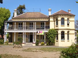
50:, a Victorian style house on the former Leigh College Campus
759:. Strathfield District Historical Society. Archived from
785:
Geographical Names Board - Media Release - Belfield
202:
190:
178:
167:
159:
149:
137:
98:
23:
623:"Strathfield South Postcode, NSW - Australia Post"
441:St Anne's Roman Catholic Church, South Strathfield
456:Commercial area, schools, churches and parklands
215:
645:"History of Strathfield Local Government Area"
842:
8:
668:
666:
583:
581:
18:Suburb of Sydney, New South Wales, Australia
674:"St. Anne's Roman Catholic Church (former)"
849:
835:
827:
608:
41:
20:
360:, which became the Village of St Anne's.
68:
684:Department of Planning & Environment
679:New South Wales State Heritage Register
577:
521:
491:Theological College located at 416-420
370:New South Wales State Heritage Register
423:, from which it was separated by the
259:
244:
227:
217:
7:
318:. The area was historically part of
463:Enfield Intermodal Logistics Centre
857:Suburbs and localities within the
593:"Strathfield South (State Suburb)"
14:
316:Strathfield local government area
310:, 13 kilometres west of the
82:Location of Strathfield South in
696:
560:
548:
543:Strathfield South Uniting Church
536:
524:
501:Australian International Academy
497:Wesleyan Theological Institution
312:Sydney central business district
67:
60:
589:Australian Bureau of Statistics
171:13 km (8 mi) west of
499:. The site is now used by the
495:. It was the successor to the
1:
724:Australian Heritage Database
427:. This was approved in 2023
417:City of Canterbury-Bankstown
939:Municipality of Strathfield
859:Municipality of Strathfield
487:was from 1915 until 1974 a
413:Municipality of Strathfield
955:
878:Flemington (Homebush West)
814:The Book of Sydney Suburbs
907:
873:
531:St Anne's Catholic Church
346:Enfield Marshalling Yards
277:
223:around Strathfield South:
218:
214:
94:
55:
40:
806:Retrieved 15 April 2017.
322:. Later it was part of
910:List of Sydney suburbs
757:Sands Sydney Directory
597:2016 Census QuickStats
396:
163:15 m (49 ft)
729:Australian Government
503:, an Islamic school.
411:which was within the
393:
802:29 June 2017 at the
797:Former Leigh College
122:33.8894°S 151.0831°E
461:includes the large
204:Federal division(s)
192:State electorate(s)
185:Strathfield Council
118: /
439:St Anne's Square:
397:
358:John Joseph Therry
127:-33.8894; 151.0831
929:Suburbs of Sydney
916:
915:
893:Strathfield South
431:Heritage listings
421:Strathfield South
330:North Strathfield
288:Strathfield South
285:
284:
281:
280:
251:Strathfield South
75:Strathfield South
25:Strathfield South
946:
851:
844:
837:
828:
807:
794:
788:
787:, 4 August 2021.
782:
776:
775:
773:
771:
765:
754:
746:
740:
739:
737:
735:
715:
709:
700:
695:
693:
691:
670:
661:
660:
658:
656:
651:on 5 August 2012
647:. Archived from
641:
635:
634:
632:
630:
625:. Australia Post
619:
613:
612:
607:
605:
603:
591:(27 June 2017).
585:
564:
552:
540:
528:
306:in the state of
216:
133:
132:
130:
129:
128:
123:
119:
116:
115:
114:
111:
71:
70:
64:
45:
36:
26:
21:
954:
953:
949:
948:
947:
945:
944:
943:
919:
918:
917:
912:
903:
869:
855:
810:
804:Wayback Machine
795:
791:
783:
779:
769:
767:
763:
752:
748:
747:
743:
733:
731:
717:
716:
712:
689:
687:
672:
671:
664:
654:
652:
643:
642:
638:
628:
626:
621:
620:
616:
601:
599:
587:
586:
579:
575:
568:
565:
556:
553:
544:
541:
532:
529:
520:
479:Think of Others
458:
449:
433:
354:
308:New South Wales
240:Burwood Heights
126:
124:
120:
117:
112:
109:
107:
105:
104:
90:
89:
88:
87:
86:
79:
78:
77:
76:
72:
51:
34:New South Wales
28:
27:
24:
19:
12:
11:
5:
952:
950:
942:
941:
936:
931:
921:
920:
914:
913:
908:
905:
904:
902:
901:
895:
890:
885:
880:
874:
871:
870:
856:
854:
853:
846:
839:
831:
825:
824:
809:
808:
789:
777:
766:on 18 May 2006
741:
710:
662:
636:
614:
576:
574:
571:
570:
569:
566:
559:
557:
555:St Anne's Hall
554:
547:
545:
542:
535:
533:
530:
523:
519:
516:
493:Liverpool Road
457:
454:
448:
445:
444:
443:
432:
429:
353:
350:
283:
282:
279:
278:
275:
274:
269:
264:
258:
257:
252:
249:
243:
242:
237:
232:
226:
225:
212:
211:
206:
200:
199:
194:
188:
187:
182:
176:
175:
169:
165:
164:
161:
157:
156:
153:
147:
146:
139:
135:
134:
102:
96:
95:
92:
91:
84:Greater Sydney
81:
80:
74:
73:
66:
65:
59:
58:
57:
56:
53:
52:
46:
38:
37:
17:
13:
10:
9:
6:
4:
3:
2:
951:
940:
937:
935:
932:
930:
927:
926:
924:
911:
906:
899:
896:
894:
891:
889:
886:
884:
881:
879:
876:
875:
872:
868:
864:
860:
852:
847:
845:
840:
838:
833:
832:
829:
823:
822:0-207-14495-8
819:
815:
812:
811:
805:
801:
798:
793:
790:
786:
781:
778:
762:
758:
751:
745:
742:
730:
726:
725:
720:
714:
711:
707:
704:
699:
685:
681:
680:
675:
669:
667:
663:
650:
646:
640:
637:
624:
618:
615:
611:
598:
594:
590:
584:
582:
578:
572:
563:
558:
551:
546:
539:
534:
527:
522:
517:
515:
513:
509:
504:
502:
498:
494:
490:
486:
485:Leigh College
482:
480:
475:
469:
466:
464:
455:
453:
446:
442:
438:
437:
436:
430:
428:
426:
422:
418:
414:
410:
405:
403:
392:
388:
386:
385:George Druitt
382:
377:
373:
371:
365:
361:
359:
351:
349:
347:
343:
339:
335:
331:
327:
325:
321:
317:
313:
309:
305:
301:
297:
293:
289:
276:
273:
270:
268:
265:
263:
260:
256:
253:
250:
248:
245:
241:
238:
236:
233:
231:
228:
224:
222:
213:
210:
207:
205:
201:
198:
195:
193:
189:
186:
183:
181:
177:
174:
170:
166:
162:
158:
154:
152:
148:
144:
140:
136:
131:
103:
101:
97:
93:
85:
63:
54:
49:
44:
39:
35:
31:
22:
16:
892:
813:
792:
780:
768:. Retrieved
761:the original
756:
744:
732:. Retrieved
722:
713:
688:. Retrieved
677:
653:. Retrieved
649:the original
639:
627:. Retrieved
617:
600:. Retrieved
596:
512:Homebush Bay
505:
483:
478:
470:
467:
459:
450:
434:
406:
398:
380:
378:
374:
366:
362:
355:
338:Hume Highway
328:
323:
319:
287:
286:
219:
141:3,546 (
47:
15:
888:Strathfield
425:Cooks River
381:Druitt Town
342:Cooks River
334:Strathfield
320:Druitt Town
235:Strathfield
197:Strathfield
151:Postcode(s)
143:2016 census
125: /
113:151°04′59″E
100:Coordinates
934:Inner West
923:Categories
863:Inner West
573:References
508:Botany Bay
447:Population
340:) and the
296:Inner West
173:Sydney CBD
138:Population
110:33°53′22″S
898:Greenacre
703:CC-BY 4.0
489:Methodist
314:, in the
304:Australia
294:, in the
247:Greenacre
160:Elevation
883:Homebush
800:Archived
770:1 August
686:. H00508
655:24 April
629:22 April
602:11 April
409:Belfield
267:Belfield
230:Rookwood
168:Location
734:17 July
706:licence
518:Gallery
402:Enfield
352:History
324:Enfield
272:Enfield
262:Lakemba
255:Enfield
221:Suburbs
48:Brundah
32:,
900:(part)
867:Sydney
820:
690:18 May
474:public
300:Sydney
292:suburb
209:Watson
180:LGA(s)
30:Sydney
764:(PDF)
753:(PDF)
290:is a
818:ISBN
772:2006
736:2018
692:2018
657:2007
631:2019
604:2018
510:and
395:line
332:and
155:2136
298:of
925::
865:,
861:,
755:.
727:.
721:.
682:.
676:.
665:^
595:.
580:^
372:.
348:.
302:,
850:e
843:t
836:v
774:.
738:.
708:.
694:.
659:.
633:.
606:.
145:)
Text is available under the Creative Commons Attribution-ShareAlike License. Additional terms may apply.