131:
28:
167:
155:
143:
101:. The layout of the forest was then managed according to the landscape approach, taking into account the historical land use in different periods. As a nature reserve, the reserve partly falls under the
205:
266:
130:
256:
217:
261:
102:
166:
56:
271:
27:
154:
142:
85:. Beginning in 1938, the site was for the most part of the 20th century used as a military training ground.
71:
276:
113:
190:
120:, of which two (D7 and D8) are within the boundaries of the reserve. It also houses some sixty
94:
76:
250:
98:
17:
121:
106:
60:
82:
232:
219:
48:
32:
52:
117:
44:
26:
112:
The province of
Drenthe is rich in archaeological remains of the
67:
206:
Cultural historical inventory of the
Strubben-Kniphorstbos
93:
In 2006 the area was placed under the administration of
31:
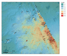
Relief map of
Drenthe Province with the distribution of
66:
The park's composite name is derived from the 'stubby'
191:
Encyclopedie
Drenthe Online: De Strubben-Kniphorstbos
43:
is a nature reserve of 377 hectares, located between
81:, who was in the 19th century the owner of the then
8:
267:Archaeological sites in the Netherlands
183:
126:
7:
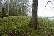
136:One of the burial mounds in the area
97:and designated as an archaeological
257:Nature reserves in the Netherlands
25:
165:
153:
141:
129:
1:
293:
262:Forests of the Netherlands
51:in the Dutch province of
57:archaeological reserve
36:
41:Strubben–Kniphorstbos
30:
18:Strubben-Kniphorstbos
272:Geography of Drenthe
114:funnelbeaker culture
70:in the area, and by
229: /
233:53.0618°N 6.6861°E
210:www.drentscheaa.nl
37:
116:, with 54 extant
99:national monument
55:. It is the only
16:(Redirected from
284:
244:
243:
241:
240:
239:
234:
230:
227:
226:
225:
222:
193:
188:
169:
157:
145:
133:
80:
72:Gerrit Kniphorst
21:
292:
291:
287:
286:
285:
283:
282:
281:
247:
246:
238:53.0618; 6.6861
237:
235:
231:
228:
223:
220:
218:
216:
215:
202:
197:
196:
189:
185:
180:
173:
170:
161:
158:
149:
146:
137:
134:
95:Staatsbosbeheer
91:
74:
23:
22:
15:
12:
11:
5:
290:
288:
280:
279:
274:
269:
264:
259:
249:
248:
213:
212:
201:
200:External links
198:
195:
194:
182:
181:
179:
176:
175:
174:
171:
164:
162:
159:
152:
150:
147:
140:
138:
135:
128:
90:
87:
24:
14:
13:
10:
9:
6:
4:
3:
2:
289:
278:
275:
273:
270:
268:
265:
263:
260:
258:
255:
254:
252:
245:
242:
211:
207:
204:
203:
199:
192:
187:
184:
177:
168:
163:
156:
151:
144:
139:
132:
127:
125:
123:
122:burial mounds
119:
115:
110:
108:
104:
100:
96:
88:
86:
84:
78:
73:
69:
64:
62:
58:
54:
50:
46:
42:
34:
29:
19:
214:
209:
186:
111:
103:Drentsche Aa
92:
65:
40:
38:
277:Aa en Hunze
236: /
172:Forest road
107:Natura 2000
75: [
61:Netherlands
251:Categories
221:53°03′42″N
178:References
83:heathlands
33:hunebedden
224:6°41′10″E
160:Dolmen D8
148:Dolmen D7
49:Schipborg
35:(dolmens)
105:area, a
118:dolmens
89:Reserve
59:in the
53:Drenthe
109:area.
79:]
45:Anloo
68:oaks
47:and
39:The
208:on
253::
124:.
77:nl
63:.
20:)
Text is available under the Creative Commons Attribution-ShareAlike License. Additional terms may apply.