51:
401:
the large floods in June 2020, Dubočica river damaged the plant washing away the road and the bank where the pipes were laid, breaking the entire pipe system, while "Brevina" clogged the tidal wave and debris, diverting the water and damaging the bridge. Both dams are named as damaging for the environment. "Brevina" is located in the Golija-Studenica
336:, but due to the overhunting, both legal and illegal, the last deer was killed in 1962. In the late 2020, 33 stags and hinds were reintroduced in an 5.2 ha (13 acres) asylum. A year later further 30 animals were released, and by June 2023 there were over 100 deer spreading along the mountain's localities Ponore and
392:
In the valley, the river has a huge hydro electrical potential, but none is used so far. In the late 1980s and early 1990s government strongly pushed a project of damming the river and building a powerful hydro electrical power plant with the artificial lake. After the public outcry and protests from
400:
in river's watershed began, so as on streams all over Serbia. Draining of the streams instigated protests and ecological, anti-micro hydro movements as people organized in various groups to protect the rivers. Two micro hydros were built on
Studenica's tributaries, "Brevina" and "Dubočica". During
301:(Brusnička River, "Brusnik River"), next to the villages of Crna Reka, Koritnik, Ratari and Pločnik. Between the villages of Devič and Čečina, the Crna Reka and Brusnička reka meet and continue to the north under the name of Studenica.
413:
registered biosphere reserve in Serbia. The river itself was completely rerouted and the natural riverbed was narrowed and left empty. "Dubočica" is also known for the arrests because of the corruption during its construction.
340:. The reintroduction program was finished in July 2023 with addition of further 11 animals. The hunting will be allowed when the number of deer crosses 200 animals.
455:
359:
in 1986). Monastery is located near the village of the same name and after the village of Kosurići, the
Studenica curves to the north emptying into the
168:
309:
The
Studenica carved a long and deep gorge-like valley, characterized by the arc-shaped stretching in the west–east direction, between the
410:
542:
528:
557:
317:(on the north) mountains. The villages of Usilje, Pridvorica, Mizdraci, Mlanča and Miliće are located in the valley, so as the
356:
28:
562:
297:(Crna River, "Black River"), at an altitude of 1,615 m. The river flows northward, parallel to the flow of the
393:
the
Serbian Orthodox Church that the artificial lake would damage the monastery the idea was finally dropped.
348:
265:
364:
150:
56:
332:, hunting on the mountain, and deciding to build Studenica Monastery there. The main game species was
344:
318:
538:
524:
459:
402:
423:
253:
446:
50:
374:
329:
551:
278:
232:
224:
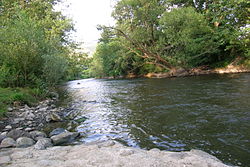
397:
310:
289:
The
Studenica originates from the central section of the northern slopes of the
228:
131:
17:
360:
325:
314:
146:
463:
183:
170:
371:
324:
The Čemerno mountain was a game hunting area from the
Medieval period, with
240:
333:
406:
352:
337:
290:
274:
236:
154:
105:
101:
72:
270:
377:, drains an area of 582 km itself, and it is not navigable.
343:
The most important feature in the entire
Studenica valley is the
507:[Micro hydros both sustained and caused harm].
488:[Deer returns to Nemanjić's hunting ground].
347:, one of the oldest, largest and most famous of all
448:
Statistical
Yearbook of the Republic of Serbia 2017
380:The name of the river, Studenica, in Serbian means
220:
215:
207:
199:
160:
140:
130:
116:
95:
87:
78:
68:
63:
39:
535:Enciklopedijski geografski leksikon Jugoslavije
505:МХЕ у поплавама прептрпеле, али и нанеле штету
8:
456:Statistical Office of the Republic of Serbia
321:Monastery and the cave on Čemerno mountain.
441:
439:
277:, a 60 km-long left tributary to the
435:
36:
355:inscribed Studenica Monastery on the
264:
7:
454:(in Serbian and English). Belgrade:
503:Višnja Aranđelović (1 July 2020).
486:Повратак јелена у немањичко ловиште
396:In the late 2010s, construction of
523:, Third edition (1985); Prosveta;
484:Miroljub Dugalić (22 June 2023).
25:
211:582 km (225 sq mi)
49:
162: • coordinates
1:
521:Mala Prosvetina Enciklopedija
370:The Studenica belongs to the
79:Physical characteristics
458:. October 2017. p. 16.
357:List of World Heritage Sites
122:1,615 m (5,299 ft)
118: • elevation
142: • location
97: • location
579:
533:Jovan Đ. Marković (1990):
328:writing about his father,
26:
492:(in Serbian). p. 14.
257:
126:
83:
48:
511:(in Serbian). p. 8.
504:
485:
558:Tributaries of the Ibar
349:Serbian Orthodox Church
203:60 km (37 mi)
537:; Svjetlost-Sarajevo;
363:at the small town of
266:[studɛ̌nitsa]
55:Studenica river near
27:For other uses, see
345:Studenica Monastery
313:(on the south) and
216:Basin features
184:43.4692°N 20.6192°E
180: /
403:Biosphere Reserve
293:mountain, as the
246:
245:
16:(Redirected from
570:
563:Rivers of Serbia
513:
512:
500:
494:
493:
481:
475:
474:
472:
470:
453:
443:
424:Rivers in Serbia
273:in southwestern
268:
263:
259:
195:
194:
192:
191:
190:
189:43.4692; 20.6192
185:
181:
178:
177:
176:
173:
119:
98:
53:
37:
21:
578:
577:
573:
572:
571:
569:
568:
567:
548:
547:
517:
516:
506:
502:
501:
497:
487:
483:
482:
478:
468:
466:
451:
445:
444:
437:
432:
420:
390:
307:
287:
261:
188:
186:
182:
179:
174:
171:
169:
167:
166:
163:
143:
117:
96:
59:
35:
34:River in Serbia
32:
23:
22:
18:Studenica River
15:
12:
11:
5:
576:
574:
566:
565:
560:
550:
549:
546:
545:
531:
515:
514:
495:
476:
434:
433:
431:
428:
427:
426:
419:
416:
389:
386:
375:drainage basin
330:Stefan Nemanja
306:
303:
299:Brusnička reka
286:
283:
244:
243:
222:
218:
217:
213:
212:
209:
205:
204:
201:
197:
196:
164:
161:
158:
157:
144:
141:
138:
137:
134:
128:
127:
124:
123:
120:
114:
113:
99:
93:
92:
89:
85:
84:
81:
80:
76:
75:
70:
66:
65:
61:
60:
54:
46:
45:
33:
24:
14:
13:
10:
9:
6:
4:
3:
2:
575:
564:
561:
559:
556:
555:
553:
544:
543:86-01-02651-6
540:
536:
532:
530:
529:86-07-00001-2
526:
522:
519:
518:
510:
499:
496:
491:
480:
477:
465:
461:
457:
450:
449:
442:
440:
436:
429:
425:
422:
421:
417:
415:
412:
408:
404:
399:
394:
387:
385:
383:
378:
376:
373:
368:
366:
362:
358:
354:
351:monasteries (
350:
346:
341:
339:
335:
334:European deer
331:
327:
322:
320:
316:
312:
304:
302:
300:
296:
292:
284:
282:
280:
276:
272:
267:
255:
251:
242:
238:
234:
230:
226:
223:
219:
214:
210:
206:
202:
198:
193:
165:
159:
156:
152:
148:
145:
139:
135:
133:
129:
125:
121:
115:
111:
107:
103:
100:
94:
90:
86:
82:
77:
74:
71:
67:
62:
58:
52:
47:
43:
38:
30:
19:
534:
520:
508:
498:
489:
479:
467:. Retrieved
447:
405:, the first
398:micro hydros
395:
391:
381:
379:
369:
342:
323:
308:
298:
294:
288:
249:
247:
233:Great Morava
109:
41:
388:Controversy
229:West Morava
221:Progression
187: /
40:Studenica (
552:Categories
430:References
382:cold water
326:Saint Sava
262:pronounced
208:Basin size
175:20°37′09″E
172:43°28′09″N
104:mountain,
464:0354-4206
372:Black Sea
319:Isposnica
295:Crna reka
258:Студеница
250:Studenica
241:Black Sea
110:Crna reka
42:Студеница
29:Studenica
509:Politika
490:Politika
418:See also
311:Radočelo
108:(as the
64:Location
315:Čemerno
281:river.
269:) is a
254:Serbian
69:Country
541:
527:
469:30 May
462:
407:UNESCO
353:UNESCO
338:Savovo
305:Valley
291:Golija
285:Origin
275:Serbia
237:Danube
200:Length
155:Serbia
136:
106:Serbia
102:Golija
91:
88:Source
73:Serbia
452:(PDF)
271:river
149:, at
132:Mouth
539:ISBN
525:ISBN
471:2018
460:ISSN
365:Ušće
361:Ibar
279:Ibar
248:The
225:Ibar
151:Ušće
147:Ibar
57:Ušće
411:MAB
554::
438:^
384:.
367:.
260:,
256::
239:→
235:→
231:→
227:→
153:,
473:.
409:-
252:(
112:)
44:)
31:.
20:)
Text is available under the Creative Commons Attribution-ShareAlike License. Additional terms may apply.