929:
844:
104:
79:
855:
1046:
1099:
111:
86:
62:
290:
construction as well. Most of the house construction took place between 1880 and 1940. The oldest houses are located on the east side of the district near the river. The secondary buildings date from around 1890 to 2010. Some of the houses were commissioned from regional architects, but for the
267:(1958). The contributing structure is St. Andrew's bell tower. The Congregational Church (1868; no longer extant) was also located here until it was torn down. All but three houses contribute to the historical significance of the district, but a majority of the secondary resources do not.
733:
828:
764:
748:
1184:
738:
258:
and south of a commercial area. It was home to middle-to-working-class families and a few business and professional people. Most of the primary resources in the district are houses, and the secondary resources are either
823:
769:
1174:
1023:
1189:
410:
790:
692:
723:
657:
622:
697:
602:
562:
387:
263:, garages, or city barns. The primary resources that are not residential include First Baptist Church (1901), the Farmers Exchange Produce Building, the Farmers Exchange Office Building (1935), and
662:
652:
647:
627:
743:
577:
492:
612:
607:
482:
702:
667:
572:
547:
687:
637:
617:
592:
582:
567:
557:
542:
522:
497:
487:
477:
707:
682:
587:
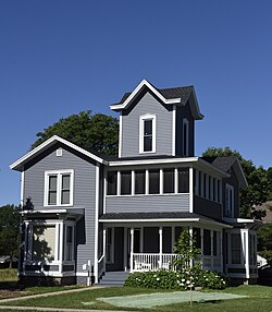
527:
507:
502:
472:
462:
999:
642:
597:
537:
512:
467:
774:
672:
552:
517:
891:
728:
677:
632:
532:
440:
425:
251:
247:
148:
1179:
380:
279:
1140:
456:
1164:
264:
103:
969:
858:
373:
1027:
974:
848:
1199:
1083:
1009:
78:
884:
1204:
1159:
420:
235:
48:
1133:
1194:
900:
877:
396:
316:
243:
39:
994:
984:
928:
811:
1126:
1076:
1004:
989:
816:
795:
286:
styles dominating the district. Most of the houses are of frame construction, but there are examples of brick and
1069:
964:
948:
278:
houses. They include a variety of the late 19th century and early 20th century architectural styles, with the
255:
132:
869:
1169:
918:
430:
191:
435:
415:
348:
321:
1106:
904:
283:
201:
254:, and 62 non-contributing buildings. The historic district is a residential area west of the
365:
341:
1110:
1053:
943:
260:
246:
in 2016. At the time of its nomination it contained 183 resources, which included 120
214:
131:
Roughly bounded by 1st & 8th Sts. SW, 1st & 5th Aves. SW, W. Bremer Ave., and
1153:
239:
136:
829:
University and college buildings listed on the
National Register of Historic Places
163:
150:
61:
1045:
1098:
275:
197:
270:
The houses range in size from single-story cottages to two-story front-
1185:
Historic districts on the
National Register of Historic Places in Iowa
824:
List of jails and prisons on the
National Register of Historic Places
287:
1024:
National
Register of Historic Places listings in Bremer County, Iowa
271:
311:
873:
369:
110:
85:
1175:
National
Register of Historic Places in Bremer County, Iowa
1190:
Houses on the
National Register of Historic Places in Iowa
291:
most part their designs were derived from pattern books.
1052:
This article about a building or structure in Iowa is a
1114:
1057:
1000:
Waverly East Bremer Avenue
Commercial Historic District
957:
936:
911:
804:
783:
757:
716:
449:
426:
History of the
National Register of Historic Places
403:
220:
207:
187:
179:
142:
127:
457:List of U.S. National Historic Landmarks by state
970:Harmon and LeValley Northwest Historic District
849:National Register of Historic Places portal
1134:
1077:
885:
381:
8:
1028:List of National Historic Landmarks in Iowa
975:Old Fourth Ward Southeast Historic District
1141:
1127:
1084:
1070:
1010:Waverly Municipal Hydroelectric Powerhouse
892:
878:
870:
388:
374:
366:
335:
333:
331:
60:
1180:Historic districts in Bremer County, Iowa
397:U.S. National Register of Historic Places
40:U.S. National Register of Historic Places
342:"Sturdevant Southwest Historic District"
16:Historic district in Iowa, United States
1165:American Craftsman architecture in Iowa
300:
980:Sturdevant Southwest Historic District
312:"National Register Information System"
306:
304:
242:, United States. It was listed on the
232:Sturdevant Southwest Historic District
32:Sturdevant Southwest Historic District
23:
7:
1105:This article about the geography of
1095:
1093:
1042:
1040:
901:National Register of Historic Places
317:National Register of Historic Places
244:National Register of Historic Places
195:Late 19th and 20th Century Revivals
812:National Historic Preservation Act
14:
1200:Iowa building and structure stubs
1097:
1044:
927:
854:
853:
842:
109:
102:
84:
77:
274:-and-wing houses and two-story
1205:Northeast Iowa geography stubs
1160:Victorian architecture in Iowa
765:Federated States of Micronesia
411:Architectural style categories
209:
66:Curtis-Osincup House (c. 1896)
1:
265:St. Andrew's Episcopal Church
118:Show map of the United States
1113:. You can help Knowledge by
1056:. You can help Knowledge by
21:United States historic place
1195:2016 establishments in Iowa
990:Wartburg Teachers' Seminary
234:is a nationally recognized
1221:
1092:
1039:
817:Historic Preservation Fund
796:American Legation, Morocco
1018:
965:Bremer County Court House
925:
837:
758:Lists by associated state
208:NRHP reference
71:
59:
55:
46:
37:
30:
26:
739:Northern Mariana Islands
188:Architectural style
164:42.723417°N 92.475667°W
919:Green Mill Ford Bridge
734:Minor Outlying Islands
717:Lists by insular areas
431:Keeper of the Register
252:contributing structure
248:contributing buildings
49:U.S. Historic district
436:National Park Service
416:Contributing property
349:National Park Service
322:National Park Service
183:41 acres (17 ha)
169:42.723417; -92.475667
791:District of Columbia
340:Marlys A. Svendsen.
1107:Bremer County, Iowa
995:Third Street Bridge
985:Third Street Bridge
905:Bremer County, Iowa
324:. January 23, 2007.
160: /
949:Sumner High School
284:American Craftsman
1122:
1121:
1065:
1064:
1034:
1033:
867:
866:
421:Historic district
236:historic district
228:
227:
1212:
1143:
1136:
1129:
1101:
1094:
1086:
1079:
1072:
1048:
1041:
931:
894:
887:
880:
871:
857:
856:
847:
846:
845:
770:Marshall Islands
390:
383:
376:
367:
360:
359:
357:
355:
346:
337:
326:
325:
308:
211:
175:
174:
172:
171:
170:
165:
161:
158:
157:
156:
153:
119:
113:
112:
106:
94:
93:Show map of Iowa
88:
87:
81:
64:
24:
1220:
1219:
1215:
1214:
1213:
1211:
1210:
1209:
1150:
1149:
1148:
1147:
1091:
1090:
1037:
1035:
1030:
1014:
953:
932:
923:
907:
898:
868:
863:
843:
841:
833:
800:
779:
753:
712:
445:
399:
394:
364:
363:
353:
351:
344:
339:
338:
329:
310:
309:
302:
297:
261:carriage houses
196:
194:
168:
166:
162:
159:
154:
151:
149:
147:
146:
135:
123:
122:
121:
120:
117:
116:
115:
114:
97:
96:
95:
92:
91:
90:
89:
67:
51:
42:
33:
22:
17:
12:
11:
5:
1218:
1216:
1208:
1207:
1202:
1197:
1192:
1187:
1182:
1177:
1172:
1167:
1162:
1152:
1151:
1146:
1145:
1138:
1131:
1123:
1120:
1119:
1102:
1089:
1088:
1081:
1074:
1066:
1063:
1062:
1049:
1032:
1031:
1019:
1016:
1015:
1013:
1012:
1007:
1002:
997:
992:
987:
982:
977:
972:
967:
961:
959:
955:
954:
952:
951:
946:
944:Bank of Sumner
940:
938:
934:
933:
926:
924:
922:
921:
915:
913:
909:
908:
899:
897:
896:
889:
882:
874:
865:
864:
862:
861:
851:
838:
835:
834:
832:
831:
826:
821:
820:
819:
808:
806:
802:
801:
799:
798:
793:
787:
785:
781:
780:
778:
777:
772:
767:
761:
759:
755:
754:
752:
751:
749:Virgin Islands
746:
741:
736:
731:
726:
724:American Samoa
720:
718:
714:
713:
711:
710:
705:
700:
695:
690:
685:
680:
675:
670:
665:
660:
658:South Carolina
655:
650:
645:
640:
635:
630:
625:
623:North Carolina
620:
615:
610:
605:
600:
595:
590:
585:
580:
575:
570:
565:
560:
555:
550:
545:
540:
535:
530:
525:
520:
515:
510:
505:
500:
495:
490:
485:
480:
475:
470:
465:
460:
453:
451:
450:Lists by state
447:
446:
444:
443:
441:Property types
438:
433:
428:
423:
418:
413:
407:
405:
401:
400:
395:
393:
392:
385:
378:
370:
362:
361:
327:
299:
298:
296:
293:
226:
225:
222:
218:
217:
212:
205:
204:
192:Late Victorian
189:
185:
184:
181:
177:
176:
144:
140:
139:
129:
125:
124:
108:
107:
101:
100:
99:
98:
83:
82:
76:
75:
74:
73:
72:
69:
68:
65:
57:
56:
53:
52:
47:
44:
43:
38:
35:
34:
31:
28:
27:
20:
15:
13:
10:
9:
6:
4:
3:
2:
1217:
1206:
1203:
1201:
1198:
1196:
1193:
1191:
1188:
1186:
1183:
1181:
1178:
1176:
1173:
1171:
1170:Waverly, Iowa
1168:
1166:
1163:
1161:
1158:
1157:
1155:
1144:
1139:
1137:
1132:
1130:
1125:
1124:
1118:
1116:
1112:
1108:
1103:
1100:
1096:
1087:
1082:
1080:
1075:
1073:
1068:
1067:
1061:
1059:
1055:
1050:
1047:
1043:
1038:
1029:
1025:
1022:
1017:
1011:
1008:
1006:
1005:Waverly House
1003:
1001:
998:
996:
993:
991:
988:
986:
983:
981:
978:
976:
973:
971:
968:
966:
963:
962:
960:
956:
950:
947:
945:
942:
941:
939:
935:
930:
920:
917:
916:
914:
910:
906:
902:
895:
890:
888:
883:
881:
876:
875:
872:
860:
852:
850:
840:
839:
836:
830:
827:
825:
822:
818:
815:
814:
813:
810:
809:
807:
803:
797:
794:
792:
789:
788:
786:
782:
776:
773:
771:
768:
766:
763:
762:
760:
756:
750:
747:
745:
742:
740:
737:
735:
732:
730:
727:
725:
722:
721:
719:
715:
709:
706:
704:
701:
699:
698:West Virginia
696:
694:
691:
689:
686:
684:
681:
679:
676:
674:
671:
669:
666:
664:
661:
659:
656:
654:
651:
649:
646:
644:
641:
639:
636:
634:
631:
629:
626:
624:
621:
619:
616:
614:
611:
609:
606:
604:
603:New Hampshire
601:
599:
596:
594:
591:
589:
586:
584:
581:
579:
576:
574:
571:
569:
566:
564:
563:Massachusetts
561:
559:
556:
554:
551:
549:
546:
544:
541:
539:
536:
534:
531:
529:
526:
524:
521:
519:
516:
514:
511:
509:
506:
504:
501:
499:
496:
494:
491:
489:
486:
484:
481:
479:
476:
474:
471:
469:
466:
464:
461:
458:
455:
454:
452:
448:
442:
439:
437:
434:
432:
429:
427:
424:
422:
419:
417:
414:
412:
409:
408:
406:
402:
398:
391:
386:
384:
379:
377:
372:
371:
368:
350:
343:
336:
334:
332:
328:
323:
319:
318:
313:
307:
305:
301:
294:
292:
289:
285:
281:
277:
273:
268:
266:
262:
257:
253:
249:
245:
241:
240:Waverly, Iowa
237:
233:
223:
221:Added to NRHP
219:
216:
213:
206:
203:
199:
193:
190:
186:
182:
178:
173:
145:
141:
138:
137:Waverly, Iowa
134:
130:
126:
105:
80:
70:
63:
58:
54:
50:
45:
41:
36:
29:
25:
19:
1115:expanding it
1104:
1058:expanding it
1051:
1036:
1020:
979:
663:South Dakota
653:Rhode Island
648:Pennsylvania
628:North Dakota
352:. Retrieved
315:
269:
231:
229:
224:May 16, 2016
155:92°28′32.4″W
152:42°43′24.3″N
18:
784:Other areas
744:Puerto Rico
578:Mississippi
493:Connecticut
276:hipped-roof
256:Cedar River
238:located in
167: /
143:Coordinates
133:Cedar River
1154:Categories
912:Janesville
693:Washington
613:New Mexico
608:New Jersey
483:California
354:August 30,
295:References
280:Queen Anne
1021:See also:
703:Wisconsin
668:Tennessee
573:Minnesota
548:Louisiana
202:Craftsman
859:Category
688:Virginia
638:Oklahoma
618:New York
593:Nebraska
583:Missouri
568:Michigan
558:Maryland
543:Kentucky
523:Illinois
498:Delaware
488:Colorado
478:Arkansas
215:16000248
198:Bungalow
128:Location
958:Waverly
805:Related
708:Wyoming
683:Vermont
588:Montana
528:Indiana
508:Georgia
503:Florida
473:Arizona
463:Alabama
937:Sumner
643:Oregon
598:Nevada
538:Kansas
513:Hawaii
468:Alaska
404:Topics
288:stucco
250:, one
1109:is a
775:Palau
673:Texas
553:Maine
518:Idaho
345:(PDF)
272:gable
1111:stub
1054:stub
1026:and
729:Guam
678:Utah
633:Ohio
533:Iowa
356:2016
282:and
230:The
180:Area
903:in
210:No.
1156::
347:.
330:^
320:.
314:.
303:^
1142:e
1135:t
1128:v
1117:.
1085:e
1078:t
1071:v
1060:.
893:e
886:t
879:v
459::
389:e
382:t
375:v
358:.
200:/
Text is available under the Creative Commons Attribution-ShareAlike License. Additional terms may apply.