129:
169:
136:
162:
419:
640:
657:
632:
611:
29:
340:). As a result, the west side of the North Cascades experiences high precipitation, especially during the winter months in the form of snowfall. During winter months, weather is usually cloudy, but, due to high pressure systems over the Pacific Ocean that intensify during summer months, there is often little or no cloud cover during the summer. Because of
406:
period dating back over two million years ago, glaciation advancing and retreating repeatedly scoured the landscape leaving deposits of rock debris. The U-shaped cross section of the river valleys is a result of recent glaciation.
364:. Geological events occurring many years ago created the diverse topography and drastic elevation changes over the Cascade Range leading to the various climate differences.
709:
570:
128:
84:
699:
662:
161:
714:
415:
in combination with glaciation have been the dominant processes which have created the tall peaks and deep valleys of the North
Cascades area.
422:
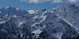
Panorama from Ruby
Mountain. Styloid is on right, nearest to camera. Distal Phalanx in upper right corner. Tricouni and Primus peaks centered.
704:
563:
233:
556:
263:
198:
77:
676:
646:
600:
283:
34:
267:
328:, they are forced upward by the peaks of the Cascade Range, causing them to drop their moisture in the form of
388:
271:
67:
57:
486:
Beckey, Fred W. Cascade Alpine Guide, Climbing and High Routes. Seattle, WA: Mountaineers Books, 2008.
372:
290:
of
Styloid Peak was made on May 31, 1981, by John Roper and party, on the same day that they climbed
384:
367:
The history of the formation of the
Cascade Mountains dates back millions of years ago to the late
202:
296:. Roper, being a doctor, named some of his many first ascents for anatomical parts of the body.
418:
321:
305:
274:
state. Its nearest higher peak is Mantis Peak, 0.33 mi (0.53 km) to the west, and
412:
341:
337:
228:
624:
396:
361:
325:
279:
275:
217:
210:
693:
590:
376:
357:
317:
313:
309:
221:
287:
282:
from
Styloid Peak drains into Neve Creek and McAllister Creek, both tributaries of
248:
548:
671:
620:
595:
447:
403:
292:
262:
is the unofficial name of a 6,972-foot (2,125-metre) mountain summit located in
99:
86:
345:
28:
333:
543:
408:
392:
380:
356:
The North
Cascades features some of the most rugged topography in the
536:
470:
368:
47:
417:
329:
552:
278:
rises 1.7 mi (2.7 km) to the west. Precipitation
482:
480:
478:
344:, snow tends to be wet and heavy, resulting in high
247:
242:
227:
209:
194:
115:
76:
66:
56:
46:
41:
21:
383:persisted. In addition, small fragments of the
564:
16:Mountain in Washington (state), United States
8:
513:
511:
509:
507:
360:with craggy peaks, spires, ridges, and deep
494:
492:
571:
557:
549:
520:The Natural History of Puget Sound Country
18:
432:
710:Mountains of Skagit County, Washington
7:
586:
442:
440:
438:
436:
168:
135:
320:, and travel northeast toward the
14:
522:. University of Washington Press.
655:
638:
630:
609:
167:
160:
134:
127:
27:
700:Mountains of Washington (state)
579:Places adjacent to Styloid Peak
498:
304:Styloid Peak is located in the
151:Show map of Washington (state)
1:
715:North American 2000 m summits
656:
610:
184:Show map of the United States
181:Location in the United States
705:North Cascades National Park
639:
631:
537:North Cascades National Park
399:about 50 million years ago.
264:North Cascades National Park
199:North Cascades National Park
52:6,972 ft (2,125 m)
518:Kruckeberg, Arthur (1991).
733:
448:"Styloid Peak, Washington"
584:
381:volcanic igneous activity
324:. As fronts approach the
253:1981 John Roper and party
120:
26:
308:climate zone of western
62:412 ft (126 m)
471:"Styloid" - ListsofJohn
389:continental lithosphere
72:Distal Phalanx 7620 ft
33:Styloid Peak seen from
423:
148:Location in Washington
100:48.63694°N 121.10167°W
539:National Park Service
421:
542:John Roper website:
373:North American Plate
105:48.63694; -121.10167
336:onto the Cascades (
96: /
424:
342:maritime influence
42:Highest point
687:
686:
682:
681:
322:Cascade Mountains
316:originate in the
306:marine west coast
257:
256:
722:
659:
658:
642:
641:
634:
633:
613:
612:
587:
573:
566:
559:
550:
524:
523:
515:
502:
496:
487:
484:
473:
468:
462:
461:
459:
458:
444:
371:Epoch. With the
213:
185:
171:
170:
164:
152:
138:
137:
131:
111:
110:
108:
107:
106:
101:
97:
94:
93:
92:
89:
31:
19:
732:
731:
725:
724:
723:
721:
720:
719:
690:
689:
688:
683:
643:
623:
580:
577:
533:
528:
527:
517:
516:
505:
497:
490:
485:
476:
469:
465:
456:
454:
446:
445:
434:
429:
375:overriding the
362:glacial valleys
354:
338:Orographic lift
302:
220:
211:
190:
189:
188:
187:
186:
183:
182:
179:
178:
177:
176:
172:
155:
154:
153:
150:
149:
146:
145:
144:
143:
139:
104:
102:
98:
95:
90:
87:
85:
83:
82:
37:
17:
12:
11:
5:
730:
729:
726:
718:
717:
712:
707:
702:
692:
691:
685:
684:
680:
679:
674:
669:
666:
665:
660:
653:
650:
649:
644:
629:
627:
625:Snowfield Peak
617:
616:
614:
607:
604:
603:
598:
593:
585:
582:
581:
578:
576:
575:
568:
561:
553:
547:
546:
540:
532:
531:External links
529:
526:
525:
503:
488:
474:
463:
452:Peakbagger.com
431:
430:
428:
425:
397:North Cascades
379:, episodes of
353:
350:
326:North Cascades
314:weather fronts
301:
298:
293:Distal Phalanx
276:Snowfield Peak
255:
254:
251:
245:
244:
240:
239:
231:
225:
224:
218:North Cascades
215:
207:
206:
196:
192:
191:
180:
174:
173:
166:
165:
159:
158:
157:
156:
147:
141:
140:
133:
132:
126:
125:
124:
123:
122:
121:
118:
117:
113:
112:
80:
74:
73:
70:
64:
63:
60:
54:
53:
50:
44:
43:
39:
38:
32:
24:
23:
15:
13:
10:
9:
6:
4:
3:
2:
728:
727:
716:
713:
711:
708:
706:
703:
701:
698:
697:
695:
678:
677:Tricouni Peak
675:
673:
670:
668:
667:
664:
661:
654:
652:
651:
648:
647:Thunder Creek
645:
637:
628:
626:
622:
619:
618:
615:
608:
606:
605:
602:
601:Ruby Mountain
599:
597:
594:
592:
591:Colonial Peak
589:
588:
583:
574:
569:
567:
562:
560:
555:
554:
551:
545:
541:
538:
535:
534:
530:
521:
514:
512:
510:
508:
504:
500:
495:
493:
489:
483:
481:
479:
475:
472:
467:
464:
453:
449:
443:
441:
439:
437:
433:
426:
420:
416:
414:
410:
405:
400:
398:
394:
390:
386:
382:
378:
377:Pacific Plate
374:
370:
365:
363:
359:
358:Cascade Range
351:
349:
347:
343:
339:
335:
331:
327:
323:
319:
318:Pacific Ocean
315:
311:
310:North America
307:
299:
297:
295:
294:
289:
285:
284:Thunder Creek
281:
277:
273:
269:
268:Skagit County
265:
261:
252:
250:
246:
241:
238:
235:
232:
230:
226:
223:
222:Cascade Range
219:
216:
214:
208:
204:
200:
197:
193:
163:
130:
119:
114:
109:
81:
79:
75:
71:
69:
65:
61:
59:
55:
51:
49:
45:
40:
36:
35:Ruby Mountain
30:
25:
20:
663:Red Mountain
636:Styloid Peak
635:
519:
466:
455:. Retrieved
451:
401:
395:created the
366:
355:
303:
291:
288:first ascent
260:Styloid Peak
259:
258:
249:First ascent
236:
212:Parent range
175:Styloid Peak
142:Styloid Peak
22:Styloid Peak
672:Primus Peak
621:Mantis Peak
596:Diablo Lake
544:RhinoClimbs
404:Pleistocene
402:During the
103: /
91:121°06′06″W
78:Coordinates
68:Parent peak
694:Categories
457:2013-02-10
427:References
272:Washington
203:Washington
88:48°38′13″N
58:Prominence
346:avalanche
116:Geography
48:Elevation
413:faulting
393:terranes
348:danger.
334:snowfall
243:Climbing
237:Ross Dam
229:Topo map
195:Location
501:, p. 16
391:called
385:oceanic
352:Geology
312:. Most
300:Climate
499:Beckey
409:Uplift
369:Eocene
286:. The
280:runoff
205:, U.S.
411:and
387:and
330:rain
234:USGS
332:or
270:of
266:in
696::
506:^
491:^
477:^
450:.
435:^
201:,
572:e
565:t
558:v
460:.
Text is available under the Creative Commons Attribution-ShareAlike License. Additional terms may apply.