269:
567:
44:
74:
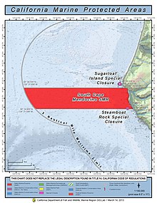
280:, a large protected marine reserve centered on Cape Mendocino fully protected by the California Department of Fish and Wildlife. The area is one of the most undeveloped sections of the California coast, and its waters are home to important bird and mammal species. Within the South Cape Mendocino State Marine Reserve, the taking of any living marine resources is prohibited. Sugarloaf Island is covered by the Cape Mendocino, California U.S. Topographic Map quadrant.
189:
261:
27:
81:
51:
647:
608:
632:
123:
627:
214:
277:
395:
601:
43:
73:
642:
452:
425:
386:
594:
356:
391:
287:
which was refined sugar in the form of a rounded cone, the most common way of distributing sugar until the late 19th century.
637:
574:
254:
204:
111:
268:
470:"Sugarloaf Island Special Closure: Northern California Marine Protected Areas (MPSs), Implemented December 2012"
303:
381:
566:
515:
307:
469:
295:
315:
448:
421:
311:
578:
330:
319:
291:
250:
160:
621:
323:
174:
299:
260:
26:
442:
329:
While it is sometimes confused with "Sugarloaf Rock," the latter is found in the
555:
420:(2nd ed.). Orangevale, CA: Dennis W. & Gloria H. Turner. p. 67.
194:
540:
490:
138:
125:
284:
516:"Final Environmental Impact Statement. Chapter 4: Biological Resources"
246:
298:. South Cape Mendocino also provides key breeding grounds for the
267:
259:
550:
290:
The area provides essential habitat and breeding grounds to the
545:
294:
and its rocky outcroppings also provide resting places for
333:
offshore San
Francisco, several hundred miles distant.
582:
551:
California Marine
Protected Areas Educational Resources
444:
Hiking the
California Coastal Trail: Oregon to Monterey
518:. California Department of Fish and Game. p. 62
210:
200:
182:
166:
154:
117:
107:
102:
283:The island is named because it is shaped like a
257:. It is the westernmost island in California
602:
416:Turner, Dennis W.; Turner, Gloria H. (2010).
8:
468:California Department of Fish and Wildlife.
19:
648:Humboldt County, California geography stubs
272:Sugar Loaf Island and special marine zone.
609:
595:
418:Place Names of Humboldt County, California
215:California Department of Fish and Wildlife
25:
18:
278:South Cape Mendocino State Marine Reserve
80:
50:
633:Geography of Humboldt County, California
493:. California Department of Fish and Game
396:United States Department of the Interior
441:Bob Lorentzen; Richard Nichols (1998).
345:
264:Sugar Loaf Island from the south-west.
541:Marine Life Protection Act Initiative
510:
508:
351:
349:
7:
628:Marine reserves of the United States
563:
561:
491:"North Coast Marine Protected Areas"
387:Geographic Names Information System
581:. You can help Knowledge (XXG) by
14:
565:
187:
79:
72:
49:
42:
392:United States Geological Survey
1:
643:Pacific islands of California
93:Show map of the United States
575:Humboldt County, California
447:. Bored Feet Publications.
255:Humboldt County, California
112:Humboldt County, California
664:
560:
243:and Sugarloaf Rock Island
171:
36:
24:
304:double-crested cormorant
139:40.438889°N 124.413806°W
577:–related article is a
273:
265:
144:40.438889; -124.413806
63:Show map of California
638:Islands of California
271:
263:
296:California sea lions
16:Island in California
382:"Sugar Loaf Island"
316:black oystercatcher
135: /
21:
357:"Sugarloaf Island"
308:Brandt's cormorant
274:
266:
590:
589:
556:YouTube of island
454:978-0-939431-18-2
427:978-0-9629617-2-4
312:pelagic cormorant
223:Sugar Loaf Island
220:
219:
87:Sugar Loaf Island
57:Sugar Loaf Island
31:Sugar Loaf Island
20:Sugar Loaf Island
655:
611:
604:
597:
569:
562:
528:
527:
525:
523:
512:
503:
502:
500:
498:
487:
481:
480:
478:
476:
465:
459:
458:
438:
432:
431:
413:
407:
406:
404:
402:
378:
372:
371:
369:
367:
361:AnyPlace America
353:
331:Farallon Islands
320:pigeon guillemot
292:Steller sea lion
235:Sugarloaf Island
225:, also known as
193:
191:
190:
157:
150:
149:
147:
146:
145:
140:
136:
133:
132:
131:
128:
94:
83:
82:
76:
64:
53:
52:
46:
29:
22:
663:
662:
658:
657:
656:
654:
653:
652:
618:
617:
616:
615:
537:
532:
531:
521:
519:
514:
513:
506:
496:
494:
489:
488:
484:
474:
472:
467:
466:
462:
455:
440:
439:
435:
428:
415:
414:
410:
400:
398:
380:
379:
375:
365:
363:
355:
354:
347:
342:
336:
239:Sugar Loaf Rock
188:
186:
178:
155:
143:
141:
137:
134:
129:
126:
124:
122:
121:
98:
97:
96:
95:
92:
91:
90:
89:
88:
84:
67:
66:
65:
62:
61:
60:
59:
58:
54:
32:
17:
12:
11:
5:
661:
659:
651:
650:
645:
640:
635:
630:
620:
619:
614:
613:
606:
599:
591:
588:
587:
570:
559:
558:
553:
548:
543:
536:
535:External links
533:
530:
529:
504:
482:
460:
453:
433:
426:
408:
373:
344:
343:
341:
338:
276:It is part of
251:Cape Mendocino
218:
217:
212:
211:Governing body
208:
207:
202:
198:
197:
184:
180:
179:
172:
169:
168:
167:Administration
164:
163:
161:Cape Mendocino
158:
152:
151:
119:
115:
114:
109:
105:
104:
100:
99:
86:
85:
78:
77:
71:
70:
69:
68:
56:
55:
48:
47:
41:
40:
39:
38:
37:
34:
33:
30:
15:
13:
10:
9:
6:
4:
3:
2:
660:
649:
646:
644:
641:
639:
636:
634:
631:
629:
626:
625:
623:
612:
607:
605:
600:
598:
593:
592:
586:
584:
580:
576:
571:
568:
564:
557:
554:
552:
549:
547:
544:
542:
539:
538:
534:
517:
511:
509:
505:
492:
486:
483:
471:
464:
461:
456:
450:
446:
445:
437:
434:
429:
423:
419:
412:
409:
397:
393:
389:
388:
383:
377:
374:
362:
358:
352:
350:
346:
339:
337:
334:
332:
327:
325:
324:tufted puffin
321:
317:
313:
309:
305:
301:
297:
293:
288:
286:
281:
279:
270:
262:
258:
256:
252:
248:
244:
240:
236:
232:
228:
224:
216:
213:
209:
206:
203:
199:
196:
185:
181:
177:
176:
175:United States
170:
165:
162:
159:
153:
148:
130:124°24′49.7″W
120:
116:
113:
110:
106:
101:
75:
45:
35:
28:
23:
583:expanding it
572:
520:. Retrieved
495:. Retrieved
485:
473:. Retrieved
463:
443:
436:
417:
411:
399:. Retrieved
385:
376:
364:. Retrieved
360:
335:
328:
300:Western gull
289:
282:
275:
242:
238:
234:
230:
226:
222:
221:
173:
127:40°26′20.0″N
522:19 November
497:19 November
156:Adjacent to
142: /
118:Coordinates
622:Categories
340:References
227:Sugar Loaf
195:California
546:CalOceans
285:sugarloaf
249:offshore
231:Cape Rock
103:Geography
205:Humboldt
108:Location
475:23 May
451:
424:
401:23 May
366:28 May
247:island
245:is an
201:County
192:
573:This
183:State
579:stub
524:2012
499:2012
477:2020
449:ISBN
422:ISBN
403:2020
368:2020
322:and
253:in
624::
507:^
394:,
390:.
384:.
359:.
348:^
326:.
318:,
314:,
310:,
306:,
302:,
241:,
237:,
233:,
229:,
610:e
603:t
596:v
585:.
526:.
501:.
479:.
457:.
430:.
405:.
370:.
Text is available under the Creative Commons Attribution-ShareAlike License. Additional terms may apply.