62:
593:
394:
46:
784:
69:
339:
drove 10,000 sheep from
Mungabareena station on the Murray on 1 March 1837 and reached Sugarloaf Creek station on about 14 March 1837. They set up their first sheep station adjacent to the intersection of Seymour Pyalong Road with Tallarook Pyalong Road, 37°05’04" S; 145°02’41" E.
343:
Sugarloaf Creek has the distinction of being the site of the first
European settlement in inland Victoria, a sheep station, and subsequently the generator of the second and third ever European settlements in inland Victoria at
419:
Clark, Ian D. Aboriginal languages and clans: an historical atlas of western and central
Victoria, 1800-1900, Dept. of Geography and Environmental Science, Monash University, Melbourne, 1990, p363.
199:
187:
61:
489:
94:
446:
Bride, T. F., John
Hepburn, Letters from Victorian Pioneers to his Excellency Charles Joseph La Trobe, Esq., Public Library of Victoria, 1895, p.53.
825:
854:
482:
844:
767:
428:
Williams, Martin, Charles Bonney and the fertile
Kilmore Plains, Victorian Historical Journal, Volume 90, No. 1, June 2019, p. 107.
475:
372:
302:. At the 2016 Australian Census Sugarloaf Creek had a population of 257. The Sugarloaf Creek itself is a tributary of the
295:
542:
175:
87:
592:
818:
192:
849:
640:
745:
740:
355:
William
Hamilton took up the Sugarloaf Creek station after Ebden and remained there for the rest of his life.
635:
811:
735:
709:
694:
663:
376:
138:
130:
650:
645:
750:
714:
699:
658:
630:
552:
455:
607:
45:
620:
615:
534:
332:
284:
204:
689:
676:
668:
625:
567:
529:
521:
345:
264:
259:
247:
239:
232:
222:
572:
314:
722:
681:
582:
562:
557:
547:
499:
349:
292:
254:
180:
166:
795:
577:
513:
326:
36:
730:
393:
17:
336:
303:
467:
838:
791:
783:
322:
406:
318:
109:
96:
307:
299:
288:
154:
227:
160:
325:
nation that inhabited a large portion of central
Victoria including
471:
799:
298:, 99 kilometres (62 mi) from the state capital,
600:
506:
291:. It is located on the Sugarloaf Creek Road in the
198:
186:
174:
147:
137:
125:
86:
30:
211:
819:
483:
8:
826:
812:
490:
476:
468:
392:
44:
27:
364:
68:
252:
237:
220:
213:
7:
780:
778:
16:For the creek in Pennsylvania, see
798:. You can help Knowledge (XXG) by
216:Localities around Sugarloaf Creek:
14:
790:This article about a location in
782:
591:
377:"Sugarloaf Creek (State Suburb)"
67:
60:
766:Territory divided with another
373:Australian Bureau of Statistics
159:97 km (60 mi) SE of
1:
855:Hume (region) geography stubs
165:27 km (17 mi) N of
153:99 km (62 mi) N of
50:Sugarloaf Creek Ebden Station
25:Region in Victoria, Australia
317:of Sugarloaf Creek are the
871:
777:
15:
845:Towns in Victoria (state)
759:
589:
283:is a locality in central
270:
214:
210:
55:
43:
381:2016 Census QuickStats
321:people, a part of the
110:37.08444°S 145.03361°E
296:local government area
458:, 24 June 1872, p. 4
333:Charles Hotson Ebden
115:-37.08444; 145.03361
329:and its surrounds.
200:Federal division(s)
188:State electorate(s)
106: /
543:Heathcote Junction
498:Localities in the
437:ibid, p. 108, 109.
315:traditional owners
850:Shire of Mitchell
807:
806:
775:
774:
500:Shire of Mitchell
293:Shire of Mitchell
278:
277:
274:
273:
181:Shire of Mitchell
862:
828:
821:
814:
786:
779:
746:Whiteheads Creek
595:
492:
485:
478:
469:
459:
453:
447:
444:
438:
435:
429:
426:
420:
417:
411:
410:
407:"REMPLAN Online"
403:
397:
396:
391:
389:
387:
375:(27 June 2017).
369:
327:Port Phillip Bay
212:
121:
120:
118:
117:
116:
111:
107:
104:
103:
102:
99:
71:
70:
64:
48:
39:
33:
28:
870:
869:
865:
864:
863:
861:
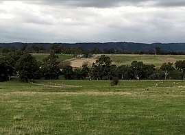
860:
859:
835:
834:
833:
832:
776:
771:
755:
705:Sugarloaf Creek
641:Heathcote South
596:
587:
502:
496:
465:
463:
462:
454:
450:
445:
441:
436:
432:
427:
423:
418:
414:
405:
404:
400:
385:
383:
371:
370:
366:
361:
281:Sugarloaf Creek
244:Sugarloaf Creek
114:
112:
108:
105:
100:
97:
95:
93:
92:
82:
81:
80:
79:
78:
77:
76:
75:Sugarloaf Creek
72:
51:
35:
34:
32:Sugarloaf Creek
31:
26:
21:
18:Sugarloaf Creek
12:
11:
5:
868:
866:
858:
857:
852:
847:
837:
836:
831:
830:
823:
816:
808:
805:
804:
787:
773:
772:
760:
757:
756:
754:
753:
748:
743:
741:Waterford Park
738:
733:
728:
720:
712:
707:
702:
697:
692:
687:
679:
674:
666:
661:
656:
648:
643:
638:
633:
628:
623:
618:
613:
604:
602:
598:
597:
590:
588:
586:
585:
580:
575:
570:
565:
560:
555:
550:
545:
540:
532:
527:
519:
510:
508:
504:
503:
497:
495:
494:
487:
480:
472:
461:
460:
448:
439:
430:
421:
412:
398:
363:
362:
360:
357:
337:Charles Bonney
304:Goulburn River
276:
275:
272:
271:
268:
267:
262:
257:
251:
250:
245:
242:
236:
235:
230:
225:
219:
218:
208:
207:
202:
196:
195:
190:
184:
183:
178:
172:
171:
170:
169:
163:
157:
149:
145:
144:
141:
135:
134:
127:
123:
122:
90:
84:
83:
74:
73:
66:
65:
59:
58:
57:
56:
53:
52:
49:
41:
40:
24:
13:
10:
9:
6:
4:
3:
2:
867:
856:
853:
851:
848:
846:
843:
842:
840:
829:
824:
822:
817:
815:
810:
809:
803:
801:
797:
793:
792:Hume (region)
788:
785:
781:
770:
769:
763:
758:
752:
749:
747:
744:
742:
739:
737:
734:
732:
729:
727:
724:
721:
719:
716:
713:
711:
708:
706:
703:
701:
698:
696:
693:
691:
688:
686:
683:
680:
678:
675:
673:
670:
667:
665:
662:
660:
657:
655:
652:
649:
647:
644:
642:
639:
637:
636:Glenhope East
634:
632:
629:
627:
624:
622:
619:
617:
614:
612:
609:
606:
605:
603:
599:
594:
584:
581:
579:
576:
574:
571:
569:
566:
564:
561:
559:
556:
554:
551:
549:
546:
544:
541:
539:
536:
533:
531:
528:
526:
523:
520:
518:
515:
512:
511:
509:
505:
501:
493:
488:
486:
481:
479:
474:
473:
470:
466:
457:
452:
449:
443:
440:
434:
431:
425:
422:
416:
413:
408:
402:
399:
395:
382:
378:
374:
368:
365:
358:
356:
353:
351:
347:
341:
338:
334:
330:
328:
324:
320:
316:
311:
309:
305:
301:
297:
294:
290:
286:
282:
269:
266:
263:
261:
258:
256:
253:
249:
246:
243:
241:
238:
234:
231:
229:
226:
224:
221:
217:
209:
206:
203:
201:
197:
194:
191:
189:
185:
182:
179:
177:
173:
168:
164:
162:
158:
156:
152:
151:
150:
146:
142:
140:
136:
132:
128:
124:
119:
91:
89:
85:
63:
54:
47:
42:
38:
29:
23:
19:
800:expanding it
789:
765:
761:
736:Upper Plenty
725:
717:
710:Sunday Creek
704:
684:
671:
664:Kilmore East
653:
610:
537:
524:
516:
464:
451:
442:
433:
424:
415:
401:
384:. Retrieved
380:
367:
354:
342:
331:
312:
280:
279:
215:
22:
751:Willowmavin
700:Reedy Creek
553:Puckapunyal
139:Postcode(s)
131:2016 census
113: /
101:145°02′01″E
88:Coordinates
839:Categories
695:Nulla Vale
616:Clonbinane
535:Flowerdale
359:References
319:Taungurung
129:244 (
126:Population
98:37°05′04″S
690:Northwood
677:Moranding
669:Mangalore
651:Highlands
646:High Camp
626:Glenaroua
568:Tallarook
530:Broadford
522:Beveridge
456:The Argus
386:25 August
346:Carlsruhe
308:Australia
300:Melbourne
289:Australia
265:Broadford
260:Broadford
248:Tallarook
240:Glenaroua
233:Tallarook
223:Glenaroua
155:Melbourne
715:Tarcombe
659:Hilldene
631:Glenhope
601:Locality
573:Tooborac
285:Victoria
228:Hilldene
205:Nicholls
148:Location
37:Victoria
723:Trawool
682:Mia Mia
608:Bylands
583:Wandong
563:Seymour
558:Pyalong
548:Kilmore
350:Kilmore
255:Pyalong
167:Kilmore
161:Bendigo
621:Forbes
578:Wallan
514:Avenel
176:LGA(s)
794:is a
731:Tyaak
323:Kulin
193:Euroa
796:stub
507:Town
388:2020
348:and
335:and
313:The
143:3658
768:LGA
306:in
841::
764:-
379:.
352:.
310:.
287:,
827:e
820:t
813:v
802:.
762:^
726:^
718:^
685:^
672:^
654:^
611:^
538:^
525:^
517:^
491:e
484:t
477:v
409:.
390:.
133:)
20:.
Text is available under the Creative Commons Attribution-ShareAlike License. Additional terms may apply.