42:
49:
225:, a popular trout stream, can be accessed via a somewhat-steep two-mile (3 km) hike along Fisherman's Trail. There are several other hiking trails of varying degrees of difficulty in proximity to Summit Lake, including one that circumnavigates the entire body of water. Some of these trails are used for
26:
536:
742:
727:
481:
318:
295:
390:
41:
207:
84:
288:
232:
Low-horsepower motor boats and row boats are permitted on the lake. Swimming is prohibited except during the annual Scenic
Mountain Triathlon.
737:
732:
281:
531:
486:
608:
506:
491:
190:
In times of drought when the Cherry River becomes too shallow, the lake can be used to supply
Richwood's municipal water system.
171:. The reservoir is formed by the impoundment of the waters of two forks of Coats Run, a small tributary of the North Fork of the
160:
70:
501:
465:
246:
222:
556:
364:
603:
354:
349:
184:
172:
445:
304:
168:
670:
541:
690:
511:
660:
680:
639:
395:
258:
180:
685:
359:
675:
344:
218:
369:
339:
334:
241:
226:
176:
655:
551:
440:
435:
116:
263:
707:
587:
572:
400:
618:
526:
455:
410:
385:
269:
Trout stocking schedule for the lake from the West
Virginia Division of Natural Resources
268:
217:
The area surrounding the lake includes a primitive 33-site campground and access to the
695:
582:
430:
425:
128:
721:
577:
164:
546:
516:
450:
420:
634:
496:
460:
415:
405:
203:
183:. These efforts, however, have had limited success with local residents and the
521:
273:
99:
86:
665:
156:
25:
199:
117:
198:
The lake is popular among fisherman, as it has an abundant supply of
264:
Locally-maintained website that features many pictures of the lake.
211:
277:
175:. There have been attempts to rename the lake in honor of
743:
Bodies of water of
Greenbrier County, West Virginia
728:
Protected areas of
Greenbrier County, West Virginia
648:
627:
596:
565:
474:
378:
327:
311:
142:
138:
127:
115:
76:
66:
18:
319:Spruce Knob–Seneca Rocks National Recreation Area
77:
289:
8:
208:West Virginia Division of Natural Resources
296:
282:
274:
15:
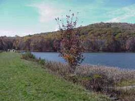
155:is a 43-acre (170,000 m) cold water
167:in the Gauley Ranger District of the
7:
48:
14:
71:Greenbrier County, West Virginia
47:
40:
24:
247:Cranberry Glades Botanical Area
141:
365:Roaring Plains West Wilderness
1:
65:
355:Laurel Fork South Wilderness
350:Laurel Fork North Wilderness
185:United States Forest Service
738:Monongahela National Forest
733:Reservoirs in West Virginia
305:Monongahela National Forest
179:, a politician from nearby
169:Monongahela National Forest
759:
671:Fernow Experimental Forest
542:South Branch Potomac River
210:also stocks the lake with
30:looking west along the dam
704:
691:Mill Point Federal Prison
312:National Recreation Areas
35:
23:
214:several times per year.
681:Highland Scenic Highway
396:Back Allegheny Mountain
206:within its waters. The
686:Middle Mountain Cabins
360:Otter Creek Wilderness
229:during winter months.
676:Gaudineer Scenic Area
379:Mountains and summits
345:Dolly Sods Wilderness
219:Cranberry Backcountry
146:43 acres (17 ha)
370:Spice Run Wilderness
340:Cranberry Wilderness
335:Big Draft Wilderness
242:Cranberry Wilderness
227:cross-country skiing
656:Bear Rocks Preserve
566:Canyons and valleys
552:Tygart Valley River
441:North Fork Mountain
96: /
628:Observation towers
436:Mount Porte Crayon
391:Allegheny Mountain
715:
714:
708:US Forest Service
666:Cheat Summit Fort
588:Smoke Hole Canyon
573:Blackwater Canyon
475:Rivers and creeks
401:Backbone Mountain
161:Greenbrier County
150:
149:
100:38.249°N 80.437°W
750:
619:Cranberry Glades
609:Spruce Knob Lake
527:Greenbrier River
492:Blackwater River
456:Shavers Mountain
328:Wilderness areas
298:
291:
284:
275:
119:
111:
110:
108:
107:
106:
101:
97:
94:
93:
92:
89:
79:
51:
50:
44:
28:
16:
758:
757:
753:
752:
751:
749:
748:
747:
718:
717:
716:
711:
700:
644:
623:
592:
561:
502:Cranberry River
470:
466:Spruce Mountain
411:Burner Mountain
386:Allegheny Front
374:
323:
307:
302:
255:
238:
223:Cranberry River
196:
131: countries
118:Primary inflows
105:38.249; -80.437
104:
102:
98:
95:
90:
87:
85:
83:
82:
62:
61:
60:
59:
58:
57:
56:
52:
31:
12:
11:
5:
756:
754:
746:
745:
740:
735:
730:
720:
719:
713:
712:
705:
702:
701:
699:
698:
696:Sinks of Gandy
693:
688:
683:
678:
673:
668:
663:
661:Camp Allegheny
658:
652:
650:
649:Other features
646:
645:
643:
642:
637:
631:
629:
625:
624:
622:
621:
616:
611:
606:
600:
598:
597:Lakes and bogs
594:
593:
591:
590:
585:
583:Germany Valley
580:
575:
569:
567:
563:
562:
560:
559:
557:Williams River
554:
549:
544:
539:
534:
529:
524:
519:
514:
509:
504:
499:
494:
489:
484:
478:
476:
472:
471:
469:
468:
463:
458:
453:
448:
443:
438:
433:
431:Gaudineer Knob
428:
426:Cheat Mountain
423:
418:
413:
408:
403:
398:
393:
388:
382:
380:
376:
375:
373:
372:
367:
362:
357:
352:
347:
342:
337:
331:
329:
325:
324:
322:
321:
315:
313:
309:
308:
303:
301:
300:
293:
286:
278:
272:
271:
266:
261:
254:
253:External links
251:
250:
249:
244:
237:
234:
195:
192:
177:Carl E. Gainer
148:
147:
144:
140:
139:
136:
135:
132:
125:
124:
121:
113:
112:
80:
74:
73:
68:
64:
63:
54:
53:
46:
45:
39:
38:
37:
36:
33:
32:
29:
21:
20:
13:
10:
9:
6:
4:
3:
2:
755:
744:
741:
739:
736:
734:
731:
729:
726:
725:
723:
710:
709:
703:
697:
694:
692:
689:
687:
684:
682:
679:
677:
674:
672:
669:
667:
664:
662:
659:
657:
654:
653:
651:
647:
641:
638:
636:
633:
632:
630:
626:
620:
617:
615:
612:
610:
607:
605:
604:Lake Sherwood
602:
601:
599:
595:
589:
586:
584:
581:
579:
578:Canaan Valley
576:
574:
571:
570:
568:
564:
558:
555:
553:
550:
548:
545:
543:
540:
538:
535:
533:
530:
528:
525:
523:
520:
518:
515:
513:
510:
508:
505:
503:
500:
498:
495:
493:
490:
488:
485:
483:
480:
479:
477:
473:
467:
464:
462:
459:
457:
454:
452:
449:
447:
444:
442:
439:
437:
434:
432:
429:
427:
424:
422:
419:
417:
414:
412:
409:
407:
404:
402:
399:
397:
394:
392:
389:
387:
384:
383:
381:
377:
371:
368:
366:
363:
361:
358:
356:
353:
351:
348:
346:
343:
341:
338:
336:
333:
332:
330:
326:
320:
317:
316:
314:
310:
306:
299:
294:
292:
287:
285:
280:
279:
276:
270:
267:
265:
262:
260:
259:Official site
257:
256:
252:
248:
245:
243:
240:
239:
235:
233:
230:
228:
224:
220:
215:
213:
209:
205:
201:
193:
191:
188:
186:
182:
178:
174:
170:
166:
165:West Virginia
162:
158:
154:
145:
137:
134:United States
133:
130:
126:
122:
120:
114:
109:
81:
75:
72:
69:
43:
34:
27:
22:
17:
706:
613:
547:Shavers Fork
537:Seneca Creek
517:Gauley River
451:Seneca Rocks
421:Champe Rocks
231:
216:
197:
189:
173:Cherry River
152:
151:
143:Surface area
640:Olson Tower
635:Bickle Knob
614:Summit Lake
532:Laurel Fork
497:Cheat River
461:Spruce Knob
446:River Knobs
416:Bickle Knob
406:Barton Knob
159:located in
153:Summit Lake
103: /
78:Coordinates
55:Summit Lake
19:Summit Lake
722:Categories
522:Glady Fork
487:Black Fork
194:Recreation
91:80°26′13″W
88:38°14′56″N
512:Elk River
157:reservoir
123:Coats Run
507:Dry Fork
236:See also
181:Richwood
67:Location
482:Big Run
200:panfish
221:. The
212:trout
129:Basin
204:bass
202:and
724::
187:.
163:,
297:e
290:t
283:v
Text is available under the Creative Commons Attribution-ShareAlike License. Additional terms may apply.