204:
108:
324:
468:
463:
516:
956:
786:
756:
961:
781:
771:
77:
863:
848:
966:
853:
751:
731:
509:
838:
843:
675:
766:
741:
710:
660:
363:
visit the park, though they are unlikely to be seen by visitors. A well-equipped
Visitors' Center has a complete list of plants and
858:
685:
502:
812:
705:
700:
670:
589:
525:
450:
The terrain between Sunol
Wilderness and Del Valle Park can be challenging. Rose Peak is the high point, only a bit lower than
203:
151:
67:
776:
761:
726:
690:
604:
579:
444:
791:
736:
695:
624:
328:
665:
644:
639:
619:
569:
544:
796:
910:
905:
680:
584:
564:
368:
344:
124:
31:
925:
884:
599:
559:
380:
614:
930:
900:
746:
574:
437:
296:
208:
175:
167:
107:
629:
429:
140:
128:
609:
549:
915:
634:
432:
linking several East Bay regional parks, passes through the Sunol
Regional Wilderness. It runs from
594:
300:
170:. It originally was inhabited by Native Americans, and was subsequently primarily ranch land, with
150:
The 27.74 square kilometres (6,850 acres) park was established in 1962, and is administered by the
144:
447:. Right to pass is subject to a permit, which is available at the Sunol Wilderness entrance gate.
817:
423:
372:
352:
281:
269:
249:
233:
217:
136:
41:
554:
304:
241:
400:
376:
257:
323:
225:
188:
950:
935:
920:
879:
539:
411:
396:
360:
265:
120:
451:
433:
340:
132:
92:
79:
308:
292:
179:
171:
494:
155:
343:, supported by large numbers of a common prey and keystone species, the
154:. The park is subject to either closure or fire restriction during the
404:
182:
485:
392:
356:
277:
192:
367:
to be seen in the park. Common amphibians and reptiles include the
440:
near
Livermore. Several backpack campgrounds exist along the way.
348:
322:
312:
364:
336:
498:
339:
species, including one of the largest breeding populations of
379:, Diablo Range garter snake, Western rattlesnake and
893:
872:
831:
805:
719:
653:
532:
63:
55:
47:
37:
27:
18:
464:Flora of the California chaparral and woodlands
291:In spring, wildflowers are abundant, including
469:Natural history of the California Coast Ranges
403:cross the park. There are also facilities for
510:
8:
517:
503:
495:
15:
443:Much of the routes land is owned by the
410:The Cave Rocks formation is popular for
202:
106:
936:Breuner Marsh (now Dotson Family Marsh)
191:within the park are still leased, so
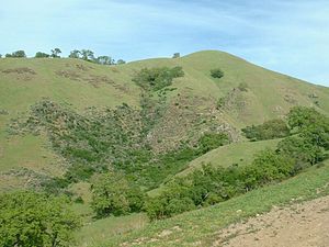
111:Hillside in Sunol Regional Wilderness
51:27.74 square kilometres (6,850 acres)
7:
957:Parks in Alameda County, California
486:East Bay Regional Parks: official
158:season from June through October.
14:
216:Common trees in the park include
135:. It is located near the town of
26:
962:East Bay Regional Park District
428:The Ohlone Wilderness trail, a
212:, in Sunol Regional Wilderness.
152:East Bay Regional Park District
68:East Bay Regional Park District
62:
46:
445:San Francisco Water Department
434:Mission Peak Regional Preserve
381:San Francisco alligator lizard
1:
329:California slender salamander
967:Regional parks in California
983:
911:Crown Memorial State Beach
421:
369:California red-legged frog
345:California ground squirrel
93:37.5101833°N 121.8285500°W
32:Alameda County, California
926:Little Hills Picnic Ranch
488:Sunol Regional Wilderness
311:, and several species of
166:The park is in the inner
117:Sunol Regional Wilderness
23:
19:Sunol Regional Wilderness
98:37.5101833; -121.8285500
931:Point Molate Beach Park
901:Ardenwood Historic Farm
526:East Bay Regional Parks
438:Del Valle Regional Park
418:Ohlone Wilderness trail
264:. Along Alameda Creek,
209:Ranunculus californicus
168:California Coast Ranges
686:Martin Luther King Jr.
430:long distance footpath
332:
213:
129:San Francisco Bay Area
112:
720:Preserves/open spaces
326:
282:California sycamore (
206:
110:
916:Eastshore State Park
436:near Fremont to the
242:Mexican elderberry (
195:may be encountered.
732:Black Diamond Mines
89: /
355:are also common.
333:
214:
113:
944:
943:
590:Dry Creek Pioneer
424:Ohlone Wilderness
373:Pacific tree frog
353:black-tailed deer
284:Platanus racemosa
272:Alnus rhombifolia
252:Arbutus menziesii
250:Pacific Madrone (
236:Quercus douglasii
220:Quercus agrifolia
73:
72:
42:Sunol, California
38:Nearest city
974:
832:Recreation areas
806:Wilderness areas
767:Morgan Territory
742:Claremont Canyon
676:Carquinez Strait
605:Pleasanton Ridge
580:Diablo Foothills
519:
512:
505:
496:
305:California Poppy
244:Sambucus cerulea
218:Coast live oak (
104:
103:
101:
100:
99:
94:
90:
87:
86:
85:
82:
64:Operated by
16:
982:
981:
977:
976:
975:
973:
972:
971:
947:
946:
945:
940:
889:
868:
827:
801:
787:Sycamore Valley
715:
649:
625:Tassajara Ridge
528:
523:
482:
477:
460:
426:
420:
401:mountain biking
389:
377:California newt
335:There are many
331:
321:
260:Pinus sabiniana
201:
164:
162:Natural history
97:
95:
91:
88:
83:
80:
78:
76:
75:
12:
11:
5:
980:
978:
970:
969:
964:
959:
949:
948:
942:
941:
939:
938:
933:
928:
923:
918:
913:
908:
903:
897:
895:
891:
890:
888:
887:
882:
876:
874:
870:
869:
867:
866:
861:
856:
851:
846:
841:
835:
833:
829:
828:
826:
825:
820:
815:
809:
807:
803:
802:
800:
799:
794:
789:
784:
782:Sobrante Ridge
779:
774:
769:
764:
759:
754:
749:
744:
739:
734:
729:
723:
721:
717:
716:
714:
713:
711:Radke Martinez
708:
703:
698:
693:
688:
683:
678:
673:
668:
663:
661:Antioch/Oakley
657:
655:
651:
650:
648:
647:
645:Wildcat Canyon
642:
640:Vargas Plateau
637:
632:
627:
622:
620:Sobrante Ridge
617:
612:
607:
602:
597:
592:
587:
582:
577:
572:
570:Crockett Hills
567:
562:
557:
552:
547:
545:Anthony Chabot
542:
536:
534:
530:
529:
524:
522:
521:
514:
507:
499:
493:
492:
481:
480:External links
478:
476:
473:
472:
471:
466:
459:
456:
454:in elevation.
419:
416:
388:
385:
361:mountain lions
327:
320:
317:
293:Chinese Houses
268:trees include
228:Quercus lobata
200:
197:
189:Grazing rights
163:
160:
127:, the eastern
125:Alameda County
84:121°49′42.78″W
71:
70:
65:
61:
60:
57:
53:
52:
49:
45:
44:
39:
35:
34:
29:
25:
24:
21:
20:
13:
10:
9:
6:
4:
3:
2:
979:
968:
965:
963:
960:
958:
955:
954:
952:
937:
934:
932:
929:
927:
924:
922:
921:Hoffman Marsh
919:
917:
914:
912:
909:
907:
906:Browns Island
904:
902:
899:
898:
896:
892:
886:
883:
881:
880:Alameda Creek
878:
877:
875:
871:
865:
864:Shadow Cliffs
862:
860:
857:
855:
852:
850:
849:Kennedy Grove
847:
845:
842:
840:
837:
836:
834:
830:
824:
821:
819:
816:
814:
811:
810:
808:
804:
798:
795:
793:
790:
788:
785:
783:
780:
778:
775:
773:
770:
768:
765:
763:
760:
758:
755:
753:
750:
748:
745:
743:
740:
738:
735:
733:
730:
728:
725:
724:
722:
718:
712:
709:
707:
704:
702:
699:
697:
694:
692:
689:
687:
684:
682:
679:
677:
674:
672:
671:Brooks Island
669:
667:
664:
662:
659:
658:
656:
652:
646:
643:
641:
638:
636:
633:
631:
628:
626:
623:
621:
618:
616:
613:
611:
608:
606:
603:
601:
598:
596:
593:
591:
588:
586:
583:
581:
578:
576:
573:
571:
568:
566:
563:
561:
558:
556:
553:
551:
548:
546:
543:
541:
540:Alvarado Park
538:
537:
535:
531:
527:
520:
515:
513:
508:
506:
501:
500:
497:
491:
489:
484:
483:
479:
474:
470:
467:
465:
462:
461:
457:
455:
453:
448:
446:
441:
439:
435:
431:
425:
417:
415:
413:
412:rock climbing
408:
406:
402:
398:
394:
386:
384:
382:
378:
374:
370:
366:
362:
358:
354:
350:
346:
342:
341:golden eagles
338:
330:
325:
318:
316:
314:
310:
306:
302:
301:monkeyflowers
298:
294:
289:
287:
285:
280:species, and
279:
275:
273:
270:White alder (
267:
263:
261:
255:
253:
247:
245:
239:
237:
231:
229:
223:
221:
211:
210:
205:
198:
196:
194:
190:
186:
184:
181:
177:
173:
169:
161:
159:
157:
153:
148:
146:
142:
138:
134:
130:
126:
122:
121:regional park
118:
109:
105:
102:
81:37°30′36.66″N
69:
66:
58:
54:
50:
43:
40:
36:
33:
30:
22:
17:
854:Quarry Lakes
822:
777:Round Valley
762:Mission Peak
757:Leona Canyon
747:Five Canyons
727:Bishop Ranch
706:Point Pinole
701:Point Isabel
585:Dublin Hills
565:Coyote Hills
487:
452:Mount Diablo
449:
442:
427:
409:
397:horse-riding
390:
334:
290:
283:
271:
259:
251:
243:
235:
227:
226:Valley oak (
219:
215:
207:
187:
176:oak woodland
165:
149:
143:and east of
116:
114:
74:
839:Cull Canyon
813:Las Trampas
792:Vasco Caves
752:Huckleberry
737:Brushy Peak
691:Miller/Knox
600:Lake Chabot
560:Contra Loma
555:Castle Rock
391:Trails for
258:Gray pine (
139:, south of
131:, Northern
96: /
951:Categories
885:Iron Horse
844:Don Castro
696:Oyster Bay
654:Shorelines
615:Ridgelands
475:References
422:See also:
309:goldfields
297:Ranunculus
234:Blue oak (
141:Pleasanton
133:California
797:Waterbird
666:Big Break
575:Del Valle
180:grassland
172:chaparral
630:Temescal
458:See also
387:Features
266:riparian
183:habitats
156:wildfire
28:Location
859:Roberts
681:Hayward
610:Redwood
550:Briones
490:website
405:camping
357:Coyotes
313:Lupines
145:Fremont
56:Created
873:Trails
818:Ohlone
772:Sibley
635:Tilden
399:, and
393:hiking
349:skunks
278:willow
193:cattle
178:, and
894:Other
823:Sunol
595:Garin
533:Parks
365:birds
319:Fauna
199:Flora
137:Sunol
119:is a
359:and
351:and
337:bird
256:and
115:The
59:1962
48:Area
123:in
953::
414:.
407:.
395:,
383:.
375:,
371:,
347:.
315:.
307:,
303:,
299:,
295:,
288:.
276:,
248:,
240:,
232:,
224:,
185:.
174:,
147:.
518:e
511:t
504:v
286:)
274:)
262:)
254:)
246:)
238:)
230:)
222:)
Text is available under the Creative Commons Attribution-ShareAlike License. Additional terms may apply.