731:
535:
76:
101:
59:
108:
83:
312:
299:
321:
287:
Because of decreasing ore quality and problems in the domestic steel market, the town and mine were closed by
Colorado Fuel and Iron in 1980. Over the lifetime of the mine 40 million tons of iron ore were produced, more than any other C.F. & I. mine. The district was added to the National
865:
860:
875:
870:
832:
256:
Colorado Fuel and Iron hoped to make
Sunrise a model company town. In the early 1900s company-owned houses, boarding houses, depots, a school, churches, shops, and other structures were built. In response to the
691:
795:
230:
453:
836:
813:
803:
684:
775:
752:
144:
762:
677:
45:
100:
700:
446:
355:
218:
36:
730:
75:
712:
770:
253:
began leasing mining rights in the area to improve its supply of iron. In 1904 Colorado Fuel and Iron bought the entire
Sunrise Mine.
855:
439:
431:
265:
building, parks, a playground, better utility systems, a hospital, and other improvements. By 1928 the mine employed 547.
229:
280:
all mining was underground. Ore mined was partially processed on site and then sent to
Colorado Fuel and Iron mills in
739:
669:
573:
613:
563:
545:
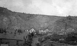
704:
649:
463:
250:
214:
210:
132:
242:
360:
249:
is named, founded the
Wyoming Railway and Iron Company to exploit iron mining in the area. In 1898, the
261:, further improvements came to the town in the 1910s and 1920s in the form of better brick housing, a
656:
747:
593:
315:
302:
128:
780:
578:
558:
553:
524:
519:
504:
485:
306:
425:
808:
720:
603:
514:
246:
237:
In the 1880s the area around what would become
Sunrise was an important area in the mining of
408:
583:
281:
866:
Industrial buildings and structures on the
National Register of Historic Places in Wyoming
568:
509:
258:
217:, United States. The entire site of the former mining district and town is listed on the
818:
608:
496:
190:
58:
849:
324:
618:
409:"National Register of Historic Places Registration, Sunrise Mine Historic District"
277:
273:
269:
478:
628:
375:
159:
146:
861:
Historic districts on the
National Register of Historic Places in Wyoming
876:
Populated places on the
National Register of Historic Places in Wyoming
833:
National
Register of Historic Places listings in Platte County, Wyoming
238:
233:
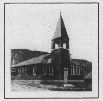
Church built for miners in Sunrise by CF&I at cost of $ 3,400.
228:
350:
320:
262:
673:
435:
871:
National Register of Historic Places in Platte County, Wyoming
533:
272:
followed by glory-hole mining. In 1930, underground
794:
761:
738:
711:
627:
592:
544:
495:
268:Initially, the mining methods used at Sunrise were
196:
183:
175:
138:
124:
837:List of National Historic Landmarks in Wyoming
804:EWZ Bridge over East Channel of Laramie River
685:
447:
8:
428:: Wyoming State Parks and Cultural Resources
776:Duncan Grant Ranch Rural Historic Landscape
411:. United States Department of the Interior.
692:
678:
670:
454:
440:
432:
374:Seligman, Edwin R. A. (November 5, 1914).
57:
753:Swan Land and Cattle Company Headquarters
37:U.S. National Register of Historic Places
107:
82:
337:
403:
401:
399:
397:
376:"Colorado's Civil War and Its Lessons"
351:"National Register Information System"
345:
343:
341:
20:
305:- runs west from Sunrise one mile to
288:Register of Historic Places in 2005.
7:
701:National Register of Historic Places
356:National Register of Historic Places
219:National Register of Historic Places
713:National Historic Landmark District
462:Municipalities and communities of
14:
209:was a company mining town of the
729:
319:
310:
297:
245:, after whom the nearby town of
106:
99:
81:
74:
786:Sunrise Mine Historic District
426:Sunrise Mine Historic District
251:Colorado Fuel and Iron company
211:Colorado Fuel and Iron Company
185:
29:Sunrise Mine Historic District
1:
115:Show map of the United States
18:United States historic place
276:mining was started, and by
892:
740:National Historic Landmark
327:, five miles to the south.
827:
727:
645:
531:
476:
184:NRHP reference
68:
56:
52:
43:
34:
27:
23:
814:Platte County Courthouse
856:Ghost towns in Wyoming
705:Platte County, Wyoming
538:
465:Platte County, Wyoming
234:
215:Platte County, Wyoming
160:42.33194°N 104.70306°W
133:Platte County, Wyoming
46:U.S. Historic district
537:
382:. Accessible Archives
380:Frank Leslie's Weekly
361:National Park Service
232:
63:Sunrise, Wyoming 1926
658:United States portal
318:, which connects to
165:42.33194; -104.70306
796:Historic properties
748:Guernsey State Park
243:Charles A. Guernsey
156: /
129:Wyoming Highway 318
90:Show map of Wyoming
781:Robert Grant Ranch
763:Historic districts
539:
235:
843:
842:
809:Patten Creek Site
721:Oregon Trail Ruts
667:
666:
363:. March 13, 2009.
309:, where it meets
247:Guernsey, Wyoming
204:
203:
200:December 23, 2005
883:
733:
694:
687:
680:
671:
659:
652:
536:
488:
481:
471:
466:
456:
449:
442:
433:
413:
412:
405:
392:
391:
389:
387:
371:
365:
364:
347:
323:
314:
313:
301:
300:
282:Pueblo, Colorado
187:
171:
170:
168:
167:
166:
161:
157:
154:
153:
152:
149:
116:
110:
109:
103:
91:
85:
84:
78:
61:
21:
891:
890:
886:
885:
884:
882:
881:
880:
846:
845:
844:
839:
823:
790:
757:
734:
725:
707:
698:
668:
663:
657:
650:
641:
623:
595:
588:
574:Westview Circle
540:
534:
529:
491:
486:
479:
472:
469:
464:
460:
422:
417:
416:
407:
406:
395:
385:
383:
373:
372:
368:
349:
348:
339:
334:
311:
298:
294:
259:Ludlow Massacre
227:
164:
162:
158:
155:
150:
147:
145:
143:
142:
120:
119:
118:
117:
114:
113:
112:
111:
94:
93:
92:
89:
88:
87:
86:
64:
48:
39:
30:
19:
12:
11:
5:
889:
887:
879:
878:
873:
868:
863:
858:
848:
847:
841:
840:
828:
825:
824:
822:
821:
819:Register Cliff
816:
811:
806:
800:
798:
792:
791:
789:
788:
783:
778:
773:
767:
765:
759:
758:
756:
755:
750:
744:
742:
736:
735:
728:
726:
724:
723:
717:
715:
709:
708:
699:
697:
696:
689:
682:
674:
665:
664:
662:
661:
654:
651:Wyoming portal
646:
643:
642:
640:
639:
633:
631:
625:
624:
622:
621:
616:
614:Dwyer Junction
611:
606:
600:
598:
590:
589:
587:
586:
581:
576:
571:
566:
564:Lakeview North
561:
556:
550:
548:
542:
541:
532:
530:
528:
527:
522:
517:
512:
507:
501:
499:
493:
492:
477:
474:
473:
461:
459:
458:
451:
444:
436:
430:
429:
421:
420:External links
418:
415:
414:
393:
366:
336:
335:
333:
330:
329:
328:
293:
290:
226:
223:
202:
201:
198:
194:
193:
188:
181:
180:
177:
173:
172:
140:
136:
135:
126:
122:
121:
105:
104:
98:
97:
96:
95:
80:
79:
73:
72:
71:
70:
69:
66:
65:
62:
54:
53:
50:
49:
44:
41:
40:
35:
32:
31:
28:
25:
24:
17:
13:
10:
9:
6:
4:
3:
2:
888:
877:
874:
872:
869:
867:
864:
862:
859:
857:
854:
853:
851:
838:
834:
831:
826:
820:
817:
815:
812:
810:
807:
805:
802:
801:
799:
797:
793:
787:
784:
782:
779:
777:
774:
772:
771:Diamond Ranch
769:
768:
766:
764:
760:
754:
751:
749:
746:
745:
743:
741:
737:
732:
722:
719:
718:
716:
714:
710:
706:
702:
695:
690:
688:
683:
681:
676:
675:
672:
660:
655:
653:
648:
647:
644:
638:
635:
634:
632:
630:
626:
620:
617:
615:
612:
610:
607:
605:
602:
601:
599:
597:
591:
585:
582:
580:
577:
575:
572:
570:
567:
565:
562:
560:
557:
555:
552:
551:
549:
547:
543:
526:
523:
521:
518:
516:
513:
511:
508:
506:
503:
502:
500:
498:
494:
490:
489:
482:
475:
470:United States
467:
457:
452:
450:
445:
443:
438:
437:
434:
427:
424:
423:
419:
410:
404:
402:
400:
398:
394:
381:
377:
370:
367:
362:
358:
357:
352:
346:
344:
342:
338:
331:
326:
325:U.S. Route 26
322:
317:
308:
304:
296:
295:
291:
289:
285:
283:
279:
275:
271:
266:
264:
260:
254:
252:
248:
244:
240:
231:
224:
222:
220:
216:
212:
208:
199:
197:Added to NRHP
195:
192:
189:
182:
178:
174:
169:
141:
137:
134:
130:
127:
123:
102:
77:
67:
60:
55:
51:
47:
42:
38:
33:
26:
22:
16:
829:
785:
636:
484:
386:February 20,
384:. Retrieved
379:
369:
354:
316:WYO 270
303:WYO 318
286:
278:World War II
274:block caving
270:strip mining
267:
255:
236:
206:
205:
15:
596:communities
480:County seat
241:. In 1890,
213:located in
163: /
151:104°42′11″W
139:Coordinates
850:Categories
629:Ghost town
332:References
148:42°19′55″N
830:See also:
579:Y-O Ranch
559:El Rancho
554:Chugcreek
525:Wheatland
520:Hartville
505:Chugwater
487:Wheatland
307:Hartville
604:Bordeaux
515:Guernsey
292:Highways
191:05000925
125:Location
637:Sunrise
584:Whiting
225:History
207:Sunrise
569:Slater
510:Glendo
239:copper
609:Dwyer
594:Other
497:Towns
176:Built
835:and
546:CDPs
388:2020
263:YMCA
179:1898
703:in
619:Uva
186:No.
852::
483::
468:,
396:^
378:.
359:.
353:.
340:^
284:.
221:.
131:,
693:e
686:t
679:v
455:e
448:t
441:v
390:.
Text is available under the Creative Commons Attribution-ShareAlike License. Additional terms may apply.