55:
599:
547:
39:
1351:
751:
706:
661:
62:
363:
Sutton Forest is located in an agrarian setting and is surrounded by farms, vineyards and is home to manor homes and estates. It is in one of the oldest areas settled by
Europeans in Australia after Sydney and is somewhat reminiscent of an English village due to the temperate
360:. Sutton Forest was originally granted, then owned by Navy Chief officer, Captain John Nicholson who recently immigrated from Scotland to Australia. This privately owned estate was originally 700 acres, this is where John Nicholson lived and died.
416:, Sutton Forest had a population of 477. 81.2% of people were born in Australia and 88.4% of people only spoke English at home. The most common responses for religion were Anglican 33.5%, Catholic 23.5% and no religion 22.0%.
1424:
239:
227:
440:
381:
1272:
54:
1395:
397:
918:
377:
It was one of the first colonial settlements outside Sydney and thus has many heritage buildings such as the
Hillview Heritage Hotel which was built in 1850s.
1108:
830:
203:
87:
1439:
179:
1078:
1419:
731:
686:
641:
736:
691:
646:
1388:
1018:
839:
1003:
365:
337:
196:
1038:
1414:
791:
546:
1033:
823:
215:
1381:
577:
524:
1103:
1058:
993:
232:
208:
1242:
1088:
1073:
1434:
1252:
1206:
1186:
1171:
1068:
978:
968:
401:
288:
191:
80:
1128:
1008:
998:
923:
816:
453:
559:
1257:
1118:
1063:
1028:
973:
958:
938:
913:
908:
878:
873:
863:
469:
353:
308:
296:
158:
1211:
1123:
1113:
1043:
1013:
963:
953:
928:
271:
170:
1151:
943:
933:
374:
In 2004, a proposal to locate Sydney's second airport in Sutton Forest met with fierce opposition from locals.
281:
1053:
1048:
1023:
988:
948:
898:
475:
313:
276:
1181:
1201:
1176:
1161:
1156:
1098:
1093:
903:
611:
581:
528:
481:
420:
413:
400:, a speaker of the House of Commons. The surrounding area is part of the lands administrative unit of the
134:
126:
1429:
1216:
1166:
808:
726:
681:
636:
1196:
1191:
220:
38:
1358:
1307:
1297:
349:
246:
184:
758:
713:
668:
771:
1302:
1277:
787:
393:
357:
1365:
1328:
1292:
1247:
754:
Text is licensed by State of New South Wales (Department of
Planning and Environment) under
709:
Text is licensed by State of New South Wales (Department of
Planning and Environment) under
664:
Text is licensed by State of New South Wales (Department of
Planning and Environment) under
251:
843:
803:
341:
29:
598:
1287:
1262:
1221:
1143:
983:
1408:
1333:
1323:
1138:
504:
492:
1350:
1267:
1282:
496:
755:
710:
665:
102:
89:
1361:
1234:
868:
345:
750:
705:
660:
371:
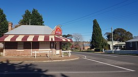
Sutton Forest comprises two churches, an inn, and two specialty shops.
333:
303:
858:
164:
464:
Sutton Forest has a number of heritage-listed sites, including:
812:
1369:
1316:
1230:
1137:
887:
851:
612:"2021 Sutton Forest, Census All persons QuickStats"
238:
226:
214:
202:
190:
178:
151:
143:
133:
118:
79:
23:
1425:Towns of the Southern Highlands (New South Wales)
435:St Patrick's Roman Catholic Church and Churchyard
786:, J. Kay McDonald, Kangaroo Press, Sydney, 1985
260:
784:Exploring the ACT and Southeast New South Wales
398:Charles Manners-Sutton, 1st Viscount Canterbury
423:, 504 people were recorded at Sutton Forrest.
1389:
824:
8:
772:"Perfect for a Sunday roast: Nic's new farm"
727:"Whitley, outbuildings, entry gate, garden"
123:
1396:
1382:
831:
817:
809:
597:
545:
432:All Saints' Anglican Church and Churchyard
37:
20:
507:and cattle stud farm within the village.
737:Department of Planning & Environment
692:Department of Planning & Environment
647:Department of Planning & Environment
732:New South Wales State Heritage Register
687:New South Wales State Heritage Register
642:New South Wales State Heritage Register
516:
352:. It is located 5 km southwest of
529:"Sutton Forest (suburb and locality)"
301:
286:
269:
262:
61:
7:
1347:
1345:
1368:. You can help Knowledge (XXG) by
441:Peppers Manor House, Sutton Forest
382:Peppers Manor House, Sutton Forest
18:Town in New South Wales, Australia
14:
533:Australian Census 2021 QuickStats
392:In 1819 it was named by Governor
43:Sutton Forest Country Store, 2023
1440:Illawarra region geography stubs
1349:
749:
704:
659:
265:Localities around Sutton Forest:
60:
53:
616:Australian Bureau of Statistics
578:Australian Bureau of Statistics
525:Australian Bureau of Statistics
384:also known as Mount Broughton.
163:141 km (88 mi) SW of
1420:Sutton Forest, New South Wales
443:also known as Mount Broughton.
169:61 km (38 mi) NE of
1:
380:It is home to the historical
454:Sutton Forest Public School
368:climate and high rainfall.
157:5 km (3 mi) W of
1456:
1344:
147:661 m (2,169 ft)
319:
263:
259:
48:
36:
1415:Towns in New South Wales
474:Old Illawarra Highway:
1253:Little (Wingecarribee)
586:2016 Census QuickStats
1258:Little (Wollondilly)
402:Sutton Forest Parish
1435:Wingecarribee Shire
1317:Tourist attractions
1308:Upper Nepean Scheme
1019:Hoddles Cross Roads
350:Wingecarribee Shire
240:Federal division(s)
228:State electorate(s)
185:Wingecarribee Shire
99: /
840:Southern Highlands
480:217 Oldbury Road:
468:Golden Vale Road:
366:Southern Highlands
338:Southern Highlands
197:Southern Highlands
103:34.567°S 150.317°E
1377:
1376:
1342:
1341:
1278:Shoalhaven Scheme
1207:Stingray Swamp FR
1187:Macquarie Pass NP
1039:Manchester Square
488:Notable residents
460:Heritage listings
412:According to the
394:Lachlan Macquarie
358:Illawarra Highway
327:
326:
323:
322:
1447:
1398:
1391:
1384:
1353:
1346:
1329:Carrington Falls
1248:Lake Burragorang
1172:Cecil Hoskins NR
833:
826:
819:
810:
776:
775:
768:
762:
753:
748:
746:
744:
723:
717:
708:
703:
701:
699:
678:
672:
663:
658:
656:
654:
633:
627:
626:
624:
622:
608:
602:
601:
596:
594:
592:
580:(27 June 2017).
574:
568:
567:
556:
550:
549:
543:
541:
539:
527:(28 June 2022).
521:
261:
125:
114:
113:
111:
110:
109:
108:-34.567; 150.317
104:
100:
97:
96:
95:
92:
64:
63:
57:
41:
32:
26:
21:
1455:
1454:
1450:
1449:
1448:
1446:
1445:
1444:
1405:
1404:
1403:
1402:
1343:
1338:
1312:
1232:
1226:
1141:
1133:
1034:Lower Mittagong
891:
889:
883:
847:
844:New South Wales
837:
800:
780:
779:
774:. 12 July 2008.
770:
769:
765:
742:
740:
725:
724:
720:
697:
695:
680:
679:
675:
652:
650:
635:
634:
630:
620:
618:
610:
609:
605:
590:
588:
582:"Sutton Forest"
576:
575:
571:
560:"Sutton Forest"
558:
557:
553:
537:
535:
523:
522:
518:
513:
503:, a 45 hectare
490:
462:
450:
429:
410:
390:
342:New South Wales
107:
105:
101:
98:
93:
90:
88:
86:
85:
75:
74:
73:
72:
71:
70:
69:
65:
44:
30:New South Wales
28:
27:
24:
19:
12:
11:
5:
1453:
1451:
1443:
1442:
1437:
1432:
1427:
1422:
1417:
1407:
1406:
1401:
1400:
1393:
1386:
1378:
1375:
1374:
1354:
1340:
1339:
1337:
1336:
1331:
1326:
1320:
1318:
1314:
1313:
1311:
1310:
1305:
1300:
1295:
1290:
1288:Warragamba Dam
1285:
1280:
1275:
1270:
1265:
1260:
1255:
1250:
1245:
1239:
1237:
1228:
1227:
1225:
1224:
1222:Wombeyan Caves
1219:
1214:
1212:Tarlo River NP
1209:
1204:
1199:
1194:
1189:
1184:
1179:
1174:
1169:
1164:
1159:
1154:
1148:
1146:
1139:National parks
1135:
1134:
1132:
1131:
1126:
1121:
1116:
1111:
1106:
1101:
1096:
1091:
1086:
1081:
1076:
1071:
1066:
1061:
1056:
1051:
1046:
1041:
1036:
1031:
1026:
1021:
1016:
1011:
1006:
1001:
996:
991:
986:
984:East Kangaloon
981:
976:
971:
966:
961:
956:
951:
946:
941:
936:
931:
926:
921:
916:
911:
906:
901:
895:
893:
892:and localities
885:
884:
882:
881:
876:
871:
866:
861:
855:
853:
849:
848:
838:
836:
835:
828:
821:
813:
807:
806:
799:
798:External links
796:
795:
794:
778:
777:
763:
718:
673:
628:
603:
569:
551:
515:
514:
512:
509:
489:
486:
485:
484:
478:
472:
461:
458:
457:
456:
449:
446:
445:
444:
437:
436:
433:
428:
425:
409:
406:
389:
386:
325:
324:
321:
320:
317:
316:
311:
306:
300:
299:
294:
291:
285:
284:
279:
274:
268:
267:
257:
256:
255:
254:
249:
242:
236:
235:
230:
224:
223:
218:
212:
211:
206:
200:
199:
194:
188:
187:
182:
176:
175:
174:
173:
167:
161:
153:
149:
148:
145:
141:
140:
137:
131:
130:
120:
116:
115:
83:
77:
76:
67:
66:
59:
58:
52:
51:
50:
49:
46:
45:
42:
34:
33:
17:
13:
10:
9:
6:
4:
3:
2:
1452:
1441:
1438:
1436:
1433:
1431:
1428:
1426:
1423:
1421:
1418:
1416:
1413:
1412:
1410:
1399:
1394:
1392:
1387:
1385:
1380:
1379:
1373:
1371:
1367:
1364:article is a
1363:
1360:
1359:Wingecarribee
1355:
1352:
1348:
1335:
1334:Fitzroy Falls
1332:
1330:
1327:
1325:
1324:Belmore Falls
1322:
1321:
1319:
1315:
1309:
1306:
1304:
1301:
1299:
1298:Wingecarribee
1296:
1294:
1291:
1289:
1286:
1284:
1281:
1279:
1276:
1274:
1271:
1269:
1266:
1264:
1261:
1259:
1256:
1254:
1251:
1249:
1246:
1244:
1241:
1240:
1238:
1236:
1229:
1223:
1220:
1218:
1215:
1213:
1210:
1208:
1205:
1203:
1200:
1198:
1195:
1193:
1190:
1188:
1185:
1183:
1180:
1178:
1175:
1173:
1170:
1168:
1165:
1163:
1160:
1158:
1155:
1153:
1152:Bangadilly NP
1150:
1149:
1147:
1145:
1140:
1136:
1130:
1127:
1125:
1122:
1120:
1117:
1115:
1112:
1110:
1107:
1105:
1104:Wildes Meadow
1102:
1100:
1097:
1095:
1092:
1090:
1087:
1085:
1084:Sutton Forest
1082:
1080:
1077:
1075:
1072:
1070:
1067:
1065:
1062:
1060:
1057:
1055:
1052:
1050:
1047:
1045:
1042:
1040:
1037:
1035:
1032:
1030:
1027:
1025:
1022:
1020:
1017:
1015:
1012:
1010:
1007:
1005:
1002:
1000:
997:
995:
994:Fitzroy Falls
992:
990:
987:
985:
982:
980:
977:
975:
972:
970:
967:
965:
962:
960:
957:
955:
952:
950:
947:
945:
942:
940:
937:
935:
932:
930:
927:
925:
922:
920:
917:
915:
912:
910:
907:
905:
902:
900:
897:
896:
894:
886:
880:
877:
875:
872:
870:
867:
865:
862:
860:
857:
856:
854:
850:
845:
841:
834:
829:
827:
822:
820:
815:
814:
811:
805:
804:Sutton Forest
802:
801:
797:
793:
792:0-86417-049-1
789:
785:
782:
781:
773:
767:
764:
760:
757:
752:
738:
734:
733:
728:
722:
719:
715:
712:
707:
693:
689:
688:
683:
677:
674:
670:
667:
662:
648:
644:
643:
638:
637:"Golden Vale"
632:
629:
617:
613:
607:
604:
600:
587:
583:
579:
573:
570:
565:
561:
555:
552:
548:
534:
530:
526:
520:
517:
510:
508:
506:
502:
498:
494:
493:Nicole Kidman
487:
483:
479:
477:
473:
471:
467:
466:
465:
459:
455:
452:
451:
447:
442:
439:
438:
434:
431:
430:
426:
424:
422:
417:
415:
407:
405:
403:
399:
395:
387:
385:
383:
378:
375:
372:
369:
367:
361:
359:
355:
351:
347:
343:
339:
335:
331:
330:Sutton Forest
318:
315:
312:
310:
307:
305:
302:
298:
295:
293:Sutton Forest
292:
290:
287:
283:
280:
278:
275:
273:
270:
266:
258:
253:
250:
248:
245:
244:
243:
241:
237:
234:
231:
229:
225:
222:
221:Sutton Forest
219:
217:
213:
210:
207:
205:
201:
198:
195:
193:
189:
186:
183:
181:
177:
172:
168:
166:
162:
160:
156:
155:
154:
150:
146:
142:
138:
136:
132:
128:
121:
117:
112:
84:
82:
78:
68:Sutton Forest
56:
47:
40:
35:
31:
25:Sutton Forest
22:
16:
1430:Hume Highway
1370:expanding it
1356:
1089:Wattle Ridge
1083:
1074:Paddys River
1059:Mount Murray
1004:Hanging Rock
783:
766:
741:. Retrieved
730:
721:
696:. Retrieved
685:
676:
651:. Retrieved
640:
631:
619:. Retrieved
615:
606:
589:. Retrieved
585:
572:
563:
554:
536:. Retrieved
532:
519:
500:
491:
463:
418:
411:
391:
379:
376:
373:
370:
362:
329:
328:
264:
15:
1303:Wollondilly
1217:Wingello SF
1167:Belanglo SF
1162:Budderoo NP
1157:Budawang NP
1109:Willow Vale
1069:New Berrima
979:East Bowral
969:Canyonleigh
890:small towns
846:, Australia
497:Keith Urban
470:Golden Vale
421:2021 census
414:2016 census
332:is a small
289:Canyonleigh
135:Postcode(s)
106: /
81:Coordinates
1409:Categories
1293:Warragamba
1235:reservoirs
1202:Penrose SF
1177:Jellore SF
1129:Yerrinbool
1009:High Range
999:Glenquarry
924:Bangadilly
852:Main towns
682:"Hillview"
511:References
501:Bunya Hill
408:Population
119:Population
1362:geography
1197:Nattai NP
1192:Morton NP
1182:Joadja NR
1119:Woodlands
1064:Myra Vale
1029:Kangaloon
974:Colo Vale
959:Burrawang
939:Bong Bong
914:Balaclava
909:Aylmerton
888:Villages,
879:Robertson
874:Moss Vale
869:Mittagong
864:Bundanoon
756:CC-BY 4.0
711:CC-BY 4.0
666:CC-BY 4.0
621:22 August
564:Visit NSW
388:Etymology
354:Moss Vale
346:Australia
309:Bundanoon
297:Moss Vale
159:Moss Vale
144:Elevation
1263:Mulwaree
1144:reserves
1124:Yarrunga
1114:Wingello
1044:Mandemar
1014:Hill Top
964:Calwalla
954:Burradoo
929:Belanglo
919:Balmoral
842:region,
739:. H00504
694:. H00442
649:. H00489
476:Hillview
427:Churches
272:Belanglo
233:Goulburn
171:Goulburn
152:Location
94:150°19′E
1079:Penrose
944:Braemar
934:Berrima
759:licence
714:licence
669:licence
591:11 July
538:28 June
482:Whitley
419:At the
356:on the
336:in the
334:village
304:Marulan
282:Berrima
247:Whitlam
91:34°34′S
1273:Paddys
1268:Nattai
1231:Rivers
1054:Meryla
1049:Medway
1024:Joadja
989:Exeter
949:Bullio
899:Alpine
859:Bowral
790:
743:18 May
698:18 May
653:18 May
544:
505:estate
448:School
396:after
314:Exeter
277:Medway
216:Parish
209:Camden
204:County
192:Region
180:LGA(s)
165:Sydney
1357:This
1283:Tarlo
1243:Burke
1099:Werai
1094:Welby
904:Avoca
122:504 (
1366:stub
1233:and
1142:and
788:ISBN
745:2018
700:2018
655:2018
623:2022
593:2017
540:2022
499:own
495:and
252:Hume
139:2577
127:2021
348:in
124:SAL
1411::
735:.
729:.
690:.
684:.
645:.
639:.
614:.
584:.
562:.
531:.
404:.
344:,
340:,
1397:e
1390:t
1383:v
1372:.
832:e
825:t
818:v
761:.
747:.
716:.
702:.
671:.
657:.
625:.
595:.
566:.
542:.
129:)
Text is available under the Creative Commons Attribution-ShareAlike License. Additional terms may apply.