55:
635:
40:
84:
153:
65:
91:
642:
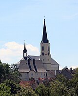
The main landmark of Světlík is the Church of Saint James the Great. It was built in the mid-13th century, its current appearance is a result of pseudo-Romanesque reconstruction in 1872–1874. The building of the rectory dates from the 18th century.
646:
The ruins of the
Pasovary Fortress are located in the northeastern part of the municipality. The fortress was founded in the 13th century. Only the torso of the masonry and the tower from the 14th century have survived.
738:
836:
1138:
1066:
54:
1002:
359:. The highest point is a hill at 855 m (2,805 ft) above sea level. The stream Strážný potok originates here and flows across the municipality.
1007:
829:
39:
1112:
367:
The first written mention of Světlík is from 1258. From 1624 until the establishment of an independent municipality in 1850, it was part of the
902:
760:
822:
83:
880:
115:
814:
634:
1117:
177:
1051:
165:
1090:
269:
890:
852:
316:
182:
934:
912:
947:
352:
746:
724:
668:
356:
1022:
863:
1027:
1045:
64:
917:
320:
248:
170:
664:
258:
1039:
720:
1096:
896:
368:
348:
972:
940:
781:
1033:
308:
1102:
1084:
1017:
324:
158:
1132:
1077:
987:
977:
966:
907:
875:
1107:
1056:
130:
117:
992:
869:
239:
847:
761:"Kostel sv. Jakuba Většího s farou a výklenková kaple sv. Jana Nepomuckého"
1061:
1012:
997:
953:
923:
982:
959:
929:
885:
626:
There are no railways or major roads passing through the municipality.
265:
244:
683:
699:
549:
473:
397:
347:
Světlík is located about 11 kilometres (7 mi) southwest of
30:
818:
807:
291:
544:
468:
392:
721:"Historický lexikon obcí České republiky 1869–2011"
286:
276:
255:
238:
230:
222:
217:
209:
201:
196:
188:
176:
164:
146:
21:
665:"Population of Municipalities – 1 January 2024"
16:Municipality in South Bohemian, Czech Republic
830:
8:
379:
339:('bright') and referred to a bright forest.
739:"Population Census 2021: Population by sex"
837:
823:
815:
378:
18:
851:, villages and military training area of
351:and 32 km (20 mi) southwest of
633:
784:(in Czech). National Heritage Institute
763:(in Czech). National Heritage Institute
656:
335:The name is derived from the adjective
285:
275:
237:
216:
208:
195:
187:
145:
110:
76:
48:
36:
254:
229:
221:
205:26.81 km (10.35 sq mi)
200:
175:
163:
7:
315:) is a municipality and village in
1139:Villages in Český Krumlov District
14:
327:. It has about 200 inhabitants.
151:
89:
82:
63:
53:
38:
1118:Boletice Military Training Area
638:Church of Saint James the Great
90:
685:Místní jména v Čechách IV: S–Ž
103:Location in the Czech Republic
1:
688:(in Czech). pp. 249–250.
1155:
782:"Zřícenina tvrze Pasovary"
383:
213:776 m (2,546 ft)
859:
682:Profous, Antonín (1957).
614:
410:—
357:Bohemian Forest Foothills
111:
77:
49:
37:
28:
747:Czech Statistical Office
725:Czech Statistical Office
702:(in Czech). Obec Světlík
669:Czech Statistical Office
44:View from the northeast
853:Český Krumlov District
639:
317:Český Krumlov District
312:
234:8.9/km (23/sq mi)
637:
380:Historical population
321:South Bohemian Region
257: • Summer (
131:48.73167°N 14.21083°E
1046:Rožmberk nad Vltavou
231: • Density
381:
127: /
1052:Rožmitál na Šumavě
864:Benešov nad Černou
640:
223: • Total
202: • Total
136:48.73167; 14.21083
1126:
1125:
973:Lipno nad Vltavou
619:
618:
610:
609:
534:
533:
458:
457:
355:. It lies in the
302:
301:
1146:
948:Hořice na Šumavě
891:Černá v Pošumaví
839:
832:
825:
816:
811:
810:
808:Official website
793:
792:
790:
789:
778:
772:
771:
769:
768:
757:
751:
750:
735:
729:
728:
717:
711:
710:
708:
707:
696:
690:
689:
679:
673:
672:
661:
615:Source: Censuses
551:
546:
538:
537:
475:
470:
462:
461:
399:
394:
386:
385:
382:
353:České Budějovice
298:
295:
293:
262:
157:
155:
154:
142:
141:
139:
138:
137:
132:
128:
125:
124:
123:
120:
93:
92:
86:
67:
57:
42:
19:
1154:
1153:
1149:
1148:
1147:
1145:
1144:
1143:
1129:
1128:
1127:
1122:
1023:Polná na Šumavě
855:
843:
806:
805:
802:
797:
796:
787:
785:
780:
779:
775:
766:
764:
759:
758:
754:
743:Public Database
737:
736:
732:
719:
718:
714:
705:
703:
698:
697:
693:
681:
680:
676:
663:
662:
658:
653:
632:
624:
377:
365:
345:
333:
290:
282:
256:
189:First mentioned
152:
150:
135:
133:
129:
126:
121:
118:
116:
114:
113:
107:
106:
105:
104:
101:
100:
99:
98:
94:
73:
72:
71:
70:
61:
60:
45:
33:
24:
17:
12:
11:
5:
1152:
1150:
1142:
1141:
1131:
1130:
1124:
1123:
1121:
1120:
1115:
1110:
1105:
1100:
1093:
1091:Věžovatá Pláně
1088:
1081:
1074:
1069:
1064:
1059:
1054:
1049:
1042:
1037:
1030:
1025:
1020:
1015:
1010:
1005:
1000:
995:
990:
985:
980:
975:
970:
963:
956:
951:
944:
937:
935:Horní Dvořiště
932:
927:
920:
918:Dolní Třebonín
915:
913:Dolní Dvořiště
910:
905:
900:
893:
888:
883:
878:
873:
866:
860:
857:
856:
844:
842:
841:
834:
827:
819:
813:
812:
801:
800:External links
798:
795:
794:
773:
752:
730:
712:
691:
674:
655:
654:
652:
649:
631:
628:
623:
620:
617:
616:
612:
611:
608:
607:
604:
601:
597:
596:
593:
590:
586:
585:
582:
579:
575:
574:
571:
568:
564:
563:
560:
557:
553:
552:
547:
542:
535:
532:
531:
528:
525:
521:
520:
517:
514:
510:
509:
506:
503:
499:
498:
495:
492:
488:
487:
484:
481:
477:
476:
471:
466:
459:
456:
455:
452:
449:
445:
444:
441:
438:
434:
433:
430:
427:
423:
422:
419:
416:
412:
411:
408:
405:
401:
400:
395:
390:
376:
373:
364:
361:
344:
341:
332:
329:
325:Czech Republic
300:
299:
288:
284:
283:
280:
278:
274:
273:
263:
253:
252:
242:
236:
235:
232:
228:
227:
224:
220:
219:
215:
214:
211:
207:
206:
203:
199:
198:
194:
193:
190:
186:
185:
180:
174:
173:
171:South Bohemian
168:
162:
161:
159:Czech Republic
148:
144:
143:
109:
108:
102:
96:
95:
88:
87:
81:
80:
79:
78:
75:
74:
68:
62:
58:
52:
51:
50:
47:
46:
43:
35:
34:
29:
26:
25:
22:
15:
13:
10:
9:
6:
4:
3:
2:
1151:
1140:
1137:
1136:
1134:
1119:
1116:
1114:
1111:
1109:
1106:
1104:
1101:
1099:
1098:
1094:
1092:
1089:
1087:
1086:
1082:
1080:
1079:
1075:
1073:
1070:
1068:
1065:
1063:
1060:
1058:
1055:
1053:
1050:
1048:
1047:
1043:
1041:
1038:
1036:
1035:
1031:
1029:
1026:
1024:
1021:
1019:
1016:
1014:
1011:
1009:
1006:
1004:
1001:
999:
996:
994:
991:
989:
986:
984:
981:
979:
976:
974:
971:
969:
968:
964:
962:
961:
957:
955:
952:
950:
949:
945:
943:
942:
938:
936:
933:
931:
928:
926:
925:
921:
919:
916:
914:
911:
909:
906:
904:
901:
899:
898:
897:Český Krumlov
894:
892:
889:
887:
884:
882:
879:
877:
874:
872:
871:
867:
865:
862:
861:
858:
854:
850:
849:
840:
835:
833:
828:
826:
821:
820:
817:
809:
804:
803:
799:
783:
777:
774:
762:
756:
753:
749:. 2021-03-27.
748:
744:
740:
734:
731:
727:. 2015-12-21.
726:
722:
716:
713:
701:
695:
692:
687:
686:
678:
675:
671:. 2024-05-17.
670:
666:
660:
657:
650:
648:
644:
636:
629:
627:
621:
613:
605:
602:
599:
598:
594:
591:
588:
587:
583:
580:
577:
576:
572:
569:
566:
565:
561:
558:
555:
554:
548:
543:
540:
539:
536:
529:
526:
523:
522:
518:
515:
512:
511:
507:
504:
501:
500:
496:
493:
490:
489:
485:
482:
479:
478:
472:
467:
464:
463:
460:
453:
450:
447:
446:
442:
439:
436:
435:
431:
428:
425:
424:
420:
417:
414:
413:
409:
406:
403:
402:
396:
391:
388:
387:
384:
374:
372:
370:
369:Český Krumlov
362:
360:
358:
354:
350:
349:Český Krumlov
342:
340:
338:
330:
328:
326:
322:
318:
314:
310:
306:
297:
289:
279:
271:
267:
264:
260:
250:
246:
243:
241:
233:
225:
212:
204:
191:
184:
183:Český Krumlov
181:
179:
172:
169:
167:
160:
149:
140:
112:Coordinates:
85:
66:
56:
41:
32:
27:
20:
1103:Zlatá Koruna
1095:
1083:
1076:
1071:
1044:
1032:
1028:Přední Výtoň
1018:Pohorská Ves
965:
958:
946:
939:
922:
895:
868:
848:market towns
846:
786:. Retrieved
776:
765:. Retrieved
755:
742:
733:
723:(in Czech).
715:
704:. Retrieved
694:
684:
677:
659:
645:
641:
625:
375:Demographics
366:
346:
336:
334:
304:
303:
294:.obecsvetlik
69:Coat of arms
31:Municipality
941:Horní Planá
876:Bohdalovice
313:Kirchschlag
277:Postal code
134: /
1097:Vyšší Brod
788:2023-01-03
767:2023-01-03
706:2023-01-03
651:References
218:Population
122:14°12′39″E
119:48°43′54″N
1003:Netřebice
993:Mirkovice
978:Loučovice
908:Chvalšiny
870:Besednice
622:Transport
343:Geography
331:Etymology
240:Time zone
210:Elevation
1133:Category
1040:Přísečná
1013:Omlenice
1008:Nová Ves
924:Frymburk
700:"O obci"
371:estate.
178:District
1108:Zubčice
1078:Velešín
1072:Světlík
1067:Střítež
1057:Soběnov
1034:Přídolí
983:Malonty
960:Kaplice
930:Holubov
903:Chlumec
886:Bujanov
845:Towns,
363:History
323:of the
319:in the
305:Světlík
287:Website
147:Country
97:Světlík
23:Světlík
1113:Zvíkov
1085:Větřní
988:Malšín
967:Křemže
630:Sights
606:+11.2%
595:−21.7%
584:+15.4%
530:−10.3%
519:−15.5%
508:−78.8%
337:světlý
309:German
281:382 16
166:Region
156:
1062:Srnín
998:Mojné
954:Kájov
881:Brloh
573:−8.4%
562:+1.6%
497:+7.1%
494:1,523
486:+1.1%
483:1,422
454:+0.6%
451:1,406
443:+0.2%
440:1,398
432:−4.5%
429:1,395
421:+3.2%
418:1,461
407:1,416
266:UTC+2
245:UTC+1
600:2021
589:2011
578:2001
567:1991
556:1980
545:Pop.
541:Year
524:1970
513:1961
502:1950
491:1930
480:1921
469:Pop.
465:Year
448:1910
437:1900
426:1890
415:1880
404:1869
393:Pop.
389:Year
270:CEST
197:Area
192:1258
59:Flag
603:229
592:206
581:263
570:228
559:249
527:245
516:273
505:323
296:.cz
292:www
259:DST
249:CET
226:238
1135::
745:.
741:.
667:.
550:±%
474:±%
398:±%
311::
838:e
831:t
824:v
791:.
770:.
709:.
307:(
272:)
268:(
261:)
251:)
247:(
Text is available under the Creative Commons Attribution-ShareAlike License. Additional terms may apply.