112:
136:
98:
124:
20:
55:
65:
Until 1665, the street was called
Gjethusstræde after Gjæthuset, a canon foundry located in the former St. Getrud's Abbey. The name was then Regnegade until 1773 when the street received its current name. The origins of the name, which directly translates as "Soot Street", is unclear. It may have
85:
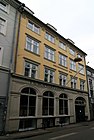
No. 3 was built by
Gotfrid Schuster in 1730 and extended with two floors in 1792. No. 9 is from 1736 and was extended with an extra floor in 1847. No. 11 is also from the 1730s and is supposedly the smallest house in Copenhagen's Old Town..
74:
There are five listed buildings in the street. No. 5 (1732) and 7 (1729) were built for captain Ernst Brandt. No. 7 was later home to the
245:
232:
284:
111:
59:
97:
135:
78:, a literary society for Norwegian students in Copenhagen which existed from 1772 until 1913. Among the members were
123:
82:. A plaque commemorating him was installed on the building by the Norwegian Society in Oslo in 1992.
79:
237:
19:
75:
103:
43:
202:
278:
39:
181:
54:
31:
260:
247:
226:
160:
35:
66:
referred to the blackened workers from the canon foundry.
60:Gedde's district map of Købmager Quarter, 1757.
8:
53:
18:
152:
93:
7:
14:
134:
122:
110:
96:
184:(in Danish). indenforvoldene.dk
163:(in Danish). indenforvoldene.dk
70:Notable buildings and residents
30:is a street in the Old Town of
1:
205:(in Danish). Kulturstyrelsen
301:
62:
24:
285:Streets in Copenhagen
57:
22:
229:on indenforvolden.dk
16:Street in Copenhagen
261:55.6811°N 12.5803°E
257: /
203:"Sag: Sværtegade 3"
80:Johan Herman Wessel
63:
58:Regnegade seen on
25:
76:Norwegian Society
292:
272:
271:
269:
268:
267:
266:55.6811; 12.5803
262:
258:
255:
254:
253:
250:
214:
213:
211:
210:
199:
193:
192:
190:
189:
178:
172:
171:
169:
168:
157:
138:
126:
114:
100:
300:
299:
295:
294:
293:
291:
290:
289:
275:
274:
265:
263:
259:
256:
251:
248:
246:
244:
243:
223:
218:
217:
208:
206:
201:
200:
196:
187:
185:
180:
179:
175:
166:
164:
159:
158:
154:
149:
142:
139:
130:
127:
118:
117:No. 5 from 1732
115:
106:
101:
92:
72:
52:
17:
12:
11:
5:
298:
296:
288:
287:
277:
276:
241:
240:
235:
230:
222:
221:External links
219:
216:
215:
194:
182:"Sværtegade 7"
173:
151:
150:
148:
145:
144:
143:
140:
133:
131:
128:
121:
119:
116:
109:
107:
102:
95:
91:
88:
71:
68:
51:
48:
38:. It connects
15:
13:
10:
9:
6:
4:
3:
2:
297:
286:
283:
282:
280:
273:
270:
239:
236:
234:
231:
228:
225:
224:
220:
204:
198:
195:
183:
177:
174:
162:
156:
153:
146:
137:
132:
125:
120:
113:
108:
105:
99:
94:
89:
87:
83:
81:
77:
69:
67:
61:
56:
49:
47:
45:
41:
37:
33:
29:
21:
242:
233:Sværtegade 5
207:. Retrieved
197:
186:. Retrieved
176:
165:. Retrieved
161:"Sværtegade"
155:
104:Sværtegade 3
84:
73:
64:
27:
26:
264: /
44:Gammel Mønt
252:12°34′49″E
249:55°40′52″N
227:Sværtegade
209:2014-10-14
188:2014-10-14
167:2014-10-14
147:References
40:Pilestræde
32:Copenhagen
28:Sværtegade
23:Sværtegade
279:Category
90:Gallery
50:History
36:Denmark
238:Source
141:No. 11
129:No. 9
42:to
281::
46:.
34:,
212:.
191:.
170:.
Text is available under the Creative Commons Attribution-ShareAlike License. Additional terms may apply.