508:- The starting and ending point of the educational trail is the Roman Catholic church of the two village. The length of the educational trail is 9.3 km. Every 50 metres of the route is a tourist sign according to the educational trail standard, and a total of 12 direction signs were installed. There are a total of 6 large (1.8 m x 1.2 m) information boards along the educational trail. In terms of content, it points out the valuable flora and fauna of the area, introduces the Cigléd pilgrimage site, presents the folk traditions and cultural-historical values of the two villages, as well as the Central European Way of Mary.
490:- Several historical sources prove that the first church of the village already existed in the 13th century, but the exact date of its building is unknown. This church with two towers, built in roman style, got several shots in the last month of the Second World War and later it was intentionally damaged. The retreating German military units had blown it up on 28 March 1945, except the sanctuary both towers and the aisle had been totally ruined. Today visitors maybe find their peace of mind among the ruins, in the cool shadow of the trees, in front of the open-air altar with a Calvary around.
472:- The archeologists of the Slovak National Museum excavated the remains of the damaged Saint Michael's church and an even older church standing on its place, between the years 1995 and 2001. They found interesting and edifying things, so the local government decided to show the findings to the public in the form of an exhibition. They have bought an other building next to the Folk-house. It is a ground-floor building with three rooms where the visitors can follow the systematized results of the researches.
93:
57:
586:
43:
1168:
191:
612:
171:
599:
502:- He was born into a noble family on June 7, 1795, in Mužla, Slovakia. His father was János Pathó, his mother was Borbála Németh. He was the deputy judge of Esztergom county and the clerk of the village of Svodín. In 1848 he was the organizer of the local national guard. He died on April 28, 1855, in a pneumonia chest in Svodín. His grave can be viewed at the local cemetery.
100:
64:
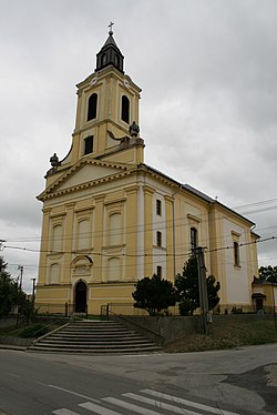
484:- This Roman Catholic church is the centre of religious life and its most important monument built in baroque style. It was sanctified in the year 1799 in honour of the Virgin Mary. It was damaged during the Second World War and rebuilt in 1957. Its interior was renewed in the years 1968 and at the end of the 80's.
478:- The first year of the International Creativ Art Camp had been organised in the village in the year 1999. Since then artists representing various creative styles, from several states (Slovakia, Hungary, Czech Republic, Poland, Romania, Canada) meet here every year.
1188:
822:
570:
33:
976:
590:
815:
716:
Károly Kocsis, Eszter
Kocsisné Hodosi, Ethnic Geography of the Hungarian Minorities in the Carpathian Basin, Simon Publications LLC, 1998, p. 46
131:
432:
was first mentioned in 1416. The town had a
Hungarian majority as early as the 17th century, according to the Turkish tax census. After the
1006:
56:
911:
717:
886:
808:
92:
338:
946:
576:
310:
667:
692:
637:
554:
1136:
832:
385:
208:
328:
163:
916:
289:
203:
1031:
936:
299:
966:
183:
449:
369:
1146:
1016:
876:
1141:
1046:
441:
790:
522:
445:
433:
844:
986:
757:
800:
1051:
1021:
585:
457:
453:
437:
42:
1182:
1131:
1061:
926:
616:
530:
891:
851:
603:
1086:
405:
389:
381:
196:
77:
1106:
1071:
881:
496:- The statue of heroes was erected in 1924 in honor of the victims of World War I.
1126:
1091:
638:"Hustota obyvateľstva - obce [om7014rr_ukaz: Rozloha (Štvorcový meter)]"
785:
1066:
981:
971:
518:
1011:
896:
146:
133:
1036:
991:
280:
1121:
996:
956:
951:
931:
858:
1167:
1156:
1101:
1041:
795:
409:
393:
176:
113:
1111:
1026:
1001:
921:
901:
871:
866:
611:
546:
542:
526:
429:
425:
377:
733:
1081:
941:
598:
306:
285:
440:
troops occupied the area, later acknowledged internationally by the
1151:
1096:
1076:
961:
906:
699:(in Slovak). Statistical Office of the Slovak Republic. 2022-03-31
674:(in Slovak). Statistical Office of the Slovak Republic. 2015-04-17
644:(in Slovak). Statistical Office of the Slovak Republic. 2022-03-31
1056:
413:
218:
804:
558:
550:
352:
444:. Between 1938 and 1945 Svodín once more became part of
347:
337:
327:
317:
296:
279:
271:
263:
258:
250:
242:
237:
229:
224:
214:
202:
182:
162:
21:
1189:Villages and municipalities in Nové Zámky District
728:
726:
724:
693:"Počet obyvateľov podľa pohlavia - obce (ročne)"
571:List of twin towns and sister cities in Slovakia
734:"Dunamente - Podunajsko - Visit Danube Region"
816:
8:
786:http://www.statistics.sk/mosmis/eng/run.html
662:
660:
658:
494:The Monument of the Victims of World War I.
460:. Since then it has been part of Slovakia.
823:
809:
801:
521:of about 2,625 people, which is about 78%
18:
506:Educational trail from Strekov to Svodín
629:
346:
336:
316:
278:
257:
249:
236:
223:
213:
161:
126:
48:
39:
796:https://www.visitdanube.eu/en/sights-7
436:army disintegrated in November 1918,
326:
295:
270:
262:
246:53.48 km (20.65 sq mi)
241:
228:
201:
181:
7:
14:
1166:
610:
597:
584:
189:
169:
98:
91:
62:
55:
41:
99:
63:
1:
412:of 202 metres and covers an
1205:
791:Svodín – Nové Zámky Okolie
668:"Základná charakteristika"
568:
565:Twin towns — sister cities
76:Location of Svodín in the
1163:
839:
127:
49:
40:
31:
764:(in Slovak). Obec Svodín
482:Church of the Assumption
254:193 m (633 ft)
82:Show map of Nitra Region
16:Municipality in Slovakia
758:"Družobné mestá a obce"
448:'s Hungary through the
452:. From 1945 until the
373:
275:45/km (120/sq mi)
112:Location of Svodín in
476:Art Gallery of Svodín
298: • Summer (
147:47.91083°N 18.49889°E
488:St. Michael's Church
470:Archeological Museum
272: • Density
118:Show map of Slovakia
967:Kamenica nad Hronom
833:Nové Zámky District
545:has a small public
500:Statue of Pál Pathó
416:of 53.606 km.
386:Nové Zámky District
209:Nové Zámky District
143: /
1032:Michal nad Žitavou
831:Municipalities of
450:First Vienna Award
426:historical records
264: • Total
243: • Total
230: • Mayor
152:47.91083; 18.49889
1176:
1175:
1137:Úľany nad Žitavou
937:Dvory nad Žitavou
697:www.statistics.sk
672:www.statistics.sk
642:www.statistics.sk
456:, it was part of
442:Treaty of Trianon
363:
362:
1196:
1171:
1170:
825:
818:
811:
802:
773:
772:
770:
769:
754:
748:
747:
745:
744:
730:
719:
714:
708:
707:
705:
704:
689:
683:
682:
680:
679:
664:
653:
652:
650:
649:
634:
615:
614:
602:
601:
593:, Czech Republic
589:
588:
557:. It also has a
434:Austro-Hungarian
359:
356:
354:
303:
195:
193:
192:
175:
173:
172:
158:
157:
155:
154:
153:
148:
144:
141:
140:
139:
136:
119:
102:
101:
95:
83:
66:
65:
59:
45:
19:
1204:
1203:
1199:
1198:
1197:
1195:
1194:
1193:
1179:
1178:
1177:
1172:
1165:
1161:
1017:Malá nad Hronom
835:
829:
782:
777:
776:
767:
765:
756:
755:
751:
742:
740:
738:Dunamente Régió
732:
731:
722:
715:
711:
702:
700:
691:
690:
686:
677:
675:
666:
665:
656:
647:
645:
636:
635:
631:
626:
609:
596:
583:
573:
567:
539:
515:
466:
422:
402:
351:
323:
297:
190:
188:
170:
168:
151:
149:
145:
142:
137:
134:
132:
130:
129:
123:
122:
121:
120:
117:
116:
110:
109:
108:
107:
103:
86:
85:
84:
81:
80:
74:
73:
72:
71:
67:
36:
27:
24:
17:
12:
11:
5:
1202:
1200:
1192:
1191:
1181:
1180:
1174:
1173:
1164:
1162:
1160:
1159:
1154:
1149:
1144:
1139:
1134:
1129:
1124:
1119:
1114:
1109:
1104:
1099:
1094:
1089:
1084:
1079:
1074:
1069:
1064:
1059:
1054:
1049:
1044:
1039:
1034:
1029:
1024:
1019:
1014:
1009:
1004:
999:
994:
989:
984:
979:
974:
969:
964:
959:
954:
949:
944:
939:
934:
929:
924:
919:
914:
909:
904:
899:
894:
889:
884:
879:
874:
869:
863:
862:
855:
848:
840:
837:
836:
830:
828:
827:
820:
813:
805:
799:
798:
793:
788:
781:
780:External links
778:
775:
774:
749:
720:
709:
684:
654:
628:
627:
625:
622:
621:
620:
607:
594:
566:
563:
561:rental store.
555:football pitch
538:
535:
514:
511:
510:
509:
503:
497:
491:
485:
479:
473:
465:
462:
458:Czechoslovakia
454:Velvet Divorce
421:
418:
401:
398:
392:of south-west
361:
360:
349:
345:
344:
341:
335:
334:
331:
325:
324:
321:
319:
315:
314:
304:
294:
293:
283:
277:
276:
273:
269:
268:
265:
261:
260:
256:
255:
252:
248:
247:
244:
240:
239:
235:
234:
231:
227:
226:
222:
221:
216:
212:
211:
206:
200:
199:
186:
180:
179:
166:
160:
159:
125:
124:
111:
105:
104:
97:
96:
90:
89:
88:
87:
75:
69:
68:
61:
60:
54:
53:
52:
51:
50:
47:
46:
38:
37:
32:
29:
28:
25:
22:
15:
13:
10:
9:
6:
4:
3:
2:
1201:
1190:
1187:
1186:
1184:
1169:
1158:
1155:
1153:
1150:
1148:
1145:
1143:
1140:
1138:
1135:
1133:
1130:
1128:
1125:
1123:
1120:
1118:
1115:
1113:
1110:
1108:
1105:
1103:
1100:
1098:
1095:
1093:
1090:
1088:
1085:
1083:
1080:
1078:
1075:
1073:
1070:
1068:
1065:
1063:
1060:
1058:
1055:
1053:
1050:
1048:
1045:
1043:
1040:
1038:
1035:
1033:
1030:
1028:
1025:
1023:
1020:
1018:
1015:
1013:
1010:
1008:
1005:
1003:
1000:
998:
995:
993:
990:
988:
985:
983:
980:
978:
975:
973:
970:
968:
965:
963:
960:
958:
955:
953:
950:
948:
945:
943:
940:
938:
935:
933:
930:
928:
925:
923:
920:
918:
915:
913:
910:
908:
905:
903:
900:
898:
895:
893:
890:
888:
885:
883:
880:
878:
875:
873:
870:
868:
865:
864:
861:
860:
856:
854:
853:
849:
847:
846:
842:
841:
838:
834:
826:
821:
819:
814:
812:
807:
806:
803:
797:
794:
792:
789:
787:
784:
783:
779:
763:
759:
753:
750:
739:
735:
729:
727:
725:
721:
718:
713:
710:
698:
694:
688:
685:
673:
669:
663:
661:
659:
655:
643:
639:
633:
630:
623:
618:
613:
608:
605:
600:
595:
592:
587:
582:
581:
580:
578:
572:
564:
562:
560:
556:
552:
548:
544:
536:
534:
532:
528:
524:
520:
512:
507:
504:
501:
498:
495:
492:
489:
486:
483:
480:
477:
474:
471:
468:
467:
463:
461:
459:
455:
451:
447:
446:Miklós Horthy
443:
439:
435:
431:
427:
419:
417:
415:
411:
407:
399:
397:
395:
391:
387:
383:
379:
375:
371:
367:
358:
350:
342:
340:
332:
330:
320:
312:
308:
305:
301:
291:
287:
284:
282:
274:
266:
253:
245:
233:Szabolcs Méri
232:
220:
217:
210:
207:
205:
198:
187:
185:
178:
167:
165:
156:
128:Coordinates:
115:
94:
79:
58:
44:
35:
30:
20:
1116:
1087:Rastislavice
977:Kamenný Most
857:
850:
843:
766:. Retrieved
761:
752:
741:. Retrieved
737:
712:
701:. Retrieved
696:
687:
676:. Retrieved
671:
646:. Retrieved
641:
632:
574:
540:
516:
505:
499:
493:
487:
481:
475:
469:
438:Czechoslovak
423:
406:municipality
403:
390:Nitra Region
382:municipality
365:
364:
333:+421 36
197:Nitra Region
78:Nitra Region
34:Municipality
1142:Veľké Lovce
1052:Nová Vieska
1022:Malé Kosihy
408:lies at an
322:943 54
318:Postal code
150: /
1132:Tvrdošovce
1062:Palárikovo
927:Dolný Ohaj
845:Nové Zámky
768:2019-09-05
743:2021-04-10
703:2022-03-31
678:2022-03-31
648:2022-03-31
624:References
575:Svodín is
569:See also:
537:Facilities
519:population
513:Population
259:Population
225:Government
138:18°29′56″E
135:47°54′39″N
1147:Veľký Kýr
1107:Sikenička
1072:Podhájska
1037:Mojzesovo
992:Komjatice
882:Bardoňovo
762:svodin.sk
619:, Hungary
523:Hungarian
517:It has a
400:Geography
370:Hungarian
339:Car plate
329:Area code
281:Time zone
251:Elevation
1183:Category
1127:Trávnica
1102:Semerovo
606:, Poland
591:Bystřice
553:, and a
410:altitude
394:Slovakia
204:District
177:Slovakia
114:Slovakia
1112:Strekov
1067:Pavlová
982:Kmeťovo
972:Kamenín
922:Dedinka
902:Branovo
892:Bešeňov
872:Bajtava
867:Andovce
852:Štúrovo
604:Pińczów
577:twinned
547:library
543:village
529:and 2%
430:village
420:History
388:in the
384:in the
378:village
376:) is a
374:Szőgyén
355:.svodin
348:Website
215:Founded
164:Country
26:Szőgyén
1122:Šarkan
1117:Svodín
1082:Radava
1007:Lipová
997:Komoča
957:Jasová
952:Chľaba
942:Gbelce
932:Dubník
917:Černík
859:Šurany
579:with:
531:Romany
527:Slovak
525:, 20%
464:Sights
366:Svodín
194:
184:Region
174:
106:Svodín
70:Svodín
23:Svodín
1157:Zemné
1152:Vlkas
1097:Salka
1092:Rúbaň
1077:Pozba
1042:Mužla
987:Kolta
962:Jatov
912:Čechy
907:Bruty
877:Bánov
307:UTC+2
286:UTC+1
267:2,401
1057:Obid
1047:Nána
1027:Maňa
1012:Ľubá
1002:Leľa
897:Bíňa
887:Belá
617:Tata
549:, a
541:The
428:the
414:area
404:The
380:and
311:CEST
238:Area
219:1156
947:Hul
559:DVD
551:gym
424:In
357:.sk
353:www
300:DST
290:CET
1185::
760:.
736:.
723:^
695:.
670:.
657:^
640:.
533:.
396:.
372::
343:NZ
824:e
817:t
810:v
771:.
746:.
706:.
681:.
651:.
368:(
313:)
309:(
302:)
292:)
288:(
Text is available under the Creative Commons Attribution-ShareAlike License. Additional terms may apply.