31:
228:
265:
117:
was constructed in 1933. The
Swartzkops watershed lies with the Uitenhage Artesian Basin. The river suffers from sewage pollution, litter, and algae blooms.
193:
142:
258:
284:
289:
251:
70:
82:
198:
94:
151:
30:
98:
90:
102:
106:
194:"Behind the Herald Headlines with Daron Mann: Swartkops Estuary pollution reaches crisis level"
36:
235:
227:
110:
168:
278:
114:
78:
66:
62:
144:
The
Geohydrology of the Swartkops River Basin - Uitenhage Region, Eastern Cape
74:
54:
86:
239:
234:
This article related to a river in South Africa is a
23:
141:Maclear, Limont Gordon Alexander (March 1996).
136:
134:
132:
130:
259:
8:
89:. Its two main tributaries are the northern
266:
252:
126:
69:. The source of the Swartkops is near
20:
16:Eastern Cape, South Africa watercourse
7:
224:
222:
163:
161:
238:. You can help Knowledge (XXG) by
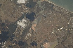
35:View of South Africa taken during
14:
226:
29:
1:
73:, and it flows east into the
150:(Master of Science thesis).
109:, which are also sources of
97:. The river is also fed by
306:
285:Rivers of the Eastern Cape
221:
61:) is a watercourse in the
199:The Herald (South Africa)
28:
290:South Africa river stubs
169:"Protecting Our Estuary"
152:University of Cape Town
173:Zwartkops Conservancy
71:Cockscombe Mountain
247:
246:
93:and the southern
44:
43:
37:ISS Expedition 18
297:
268:
261:
254:
230:
223:
211:
210:
208:
207:
190:
184:
183:
181:
180:
165:
156:
155:
149:
138:
99:Motherwell Canal
33:
21:
305:
304:
300:
299:
298:
296:
295:
294:
275:
274:
273:
272:
219:
215:
214:
205:
203:
192:
191:
187:
178:
176:
167:
166:
159:
147:
140:
139:
128:
123:
111:water pollution
91:Kwa-Zunga River
85:, just outside
51:Zwartskop River
47:Swartkops River
40:
24:Swartkops River
17:
12:
11:
5:
303:
301:
293:
292:
287:
277:
276:
271:
270:
263:
256:
248:
245:
244:
231:
213:
212:
185:
157:
125:
124:
122:
119:
113:. The river's
42:
41:
34:
26:
25:
15:
13:
10:
9:
6:
4:
3:
2:
302:
291:
288:
286:
283:
282:
280:
269:
264:
262:
257:
255:
250:
249:
243:
241:
237:
232:
229:
225:
220:
217:
201:
200:
195:
189:
186:
174:
170:
164:
162:
158:
153:
146:
145:
137:
135:
133:
131:
127:
120:
118:
116:
112:
108:
104:
103:Markman Canal
100:
96:
92:
88:
84:
83:Bluewater Bay
80:
76:
72:
68:
64:
60:
56:
52:
48:
38:
32:
27:
22:
19:
240:expanding it
233:
218:
216:
204:. Retrieved
202:. 2022-03-30
197:
188:
177:. Retrieved
172:
143:
115:Groendal Dam
107:Chatty River
95:Elands River
79:Indian Ocean
67:South Africa
65:province of
63:Eastern Cape
58:
50:
46:
45:
18:
59:black hills
279:Categories
206:2022-12-17
179:2022-12-17
121:References
75:Algoa Bay
55:Afrikaans
87:Gqeberha
77:of the
49:, also
175:. 2021
105:, and
39:, 2008
148:(PDF)
236:stub
81:in
53:, (
281::
196:.
171:.
160:^
129:^
101:,
57::
267:e
260:t
253:v
242:.
209:.
182:.
154:.
Text is available under the Creative Commons Attribution-ShareAlike License. Additional terms may apply.