28:
236:
276:
483:
148:
327:
488:
142:
320:
258:
Approximately 1 km south-east of the summit is the fell's other high point, Swarth Fell Pike (651 m, 2136 ft).
95:
493:
426:
431:
416:
210:
313:
67:
57:
503:
224:, lies 2.1 km to the south of the summit of Wild Boar Fell, the two fells being separated by a
462:
378:
358:
79:
421:
498:
337:
264:
202:
161:
156:
383:
305:
393:
345:
221:
188:
184:
128:
88:
72:
27:
179:
is an approximately 1 mile (1.5 km) stretch of high ground (consisting mainly of
477:
436:
408:
225:
217:
216:
The summit, (681m, 2234 ft) which is marked by a cairn, and is listed as both a
84:
363:
446:
373:
229:
206:
194:
113:
353:
260:
291:
278:
268:
248:
180:
398:
388:
247:
fell, like most of the names of geographical features in the area, is of
135:
235:
198:
121:
117:
239:
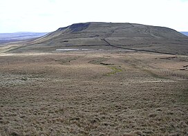
Swarth Fell in evening sunlight, seen from
Mallerstang, looking south.
368:
232:. (This small tarn can just be seen in the photograph above right).
47:
267:, is 5.3 km to the south-west, separated from Swarth Fell by
234:
213:) runs along its length, just to the west of the highest points.
175:
309:
228:- where there are several cairns, and a small unnamed
455:
407:
344:
155:
141:
127:
109:
104:
94:
78:
66:
56:
46:
41:
20:
321:
8:
328:
314:
306:
17:
201:, but the boundary between Cumbria and
484:Mountains and hills of North Yorkshire
7:
14:
191:, of which it is a continuation.
26:
32:Swarth Fell from Wild Boar Fell
489:Mountains and hills of Cumbria
1:
187:) situated to the south of
35:(Photo by John Illingworth)
520:
52:681 m (2,234 ft)
100:54° 21' 0" N 2° 22' 54" W
25:
211:West Riding of Yorkshire
62:76 m (249 ft)
336:Hills of the Northern
240:
238:
292:54.36487°N 2.37741°W
193:It is mostly within
379:Nine Standards Rigg
288: /
494:Hewitts of England
359:Great Shunner Fell
297:54.36487; -2.37741
255:, dark in colour.
241:
42:Highest point
471:
470:
171:
170:
36:
511:
330:
323:
316:
307:
303:
302:
300:
299:
298:
293:
289:
286:
285:
284:
281:
151:
131:
34:
30:
18:
519:
518:
514:
513:
512:
510:
509:
508:
474:
473:
472:
467:
451:
403:
340:
338:Yorkshire Dales
334:
296:
294:
290:
287:
282:
279:
277:
275:
274:
265:Yorkshire Dales
259:
203:North Yorkshire
192:
147:
129:
37:
33:
12:
11:
5:
517:
515:
507:
506:
501:
496:
491:
486:
476:
475:
469:
468:
466:
465:
459:
457:
453:
452:
450:
449:
444:
439:
434:
429:
424:
419:
413:
411:
405:
404:
402:
401:
396:
394:Wild Boar Fell
391:
386:
381:
376:
371:
366:
361:
356:
350:
348:
342:
341:
335:
333:
332:
325:
318:
310:
205:(historically
189:Wild Boar Fell
185:millstone grit
169:
168:
159:
153:
152:
145:
139:
138:
133:
125:
124:
111:
107:
106:
102:
101:
98:
92:
91:
82:
76:
75:
73:Wild Boar Fell
70:
64:
63:
60:
54:
53:
50:
44:
43:
39:
38:
31:
23:
22:
13:
10:
9:
6:
4:
3:
2:
516:
505:
502:
500:
497:
495:
492:
490:
487:
485:
482:
481:
479:
464:
461:
460:
458:
454:
448:
445:
443:
440:
438:
437:Randygill Top
435:
433:
430:
428:
425:
423:
420:
418:
415:
414:
412:
410:
406:
400:
397:
395:
392:
390:
387:
385:
382:
380:
377:
375:
372:
370:
367:
365:
362:
360:
357:
355:
352:
351:
349:
347:
343:
339:
331:
326:
324:
319:
317:
312:
311:
308:
304:
301:
272:
270:
266:
262:
256:
254:
250:
246:
237:
233:
231:
227:
223:
219:
214:
212:
208:
204:
200:
196:
190:
186:
182:
178:
177:
166:
163:
160:
158:
154:
150:
146:
144:
140:
137:
134:
132:
126:
123:
119:
115:
112:
108:
103:
99:
97:
93:
90:
86:
83:
81:
77:
74:
71:
69:
65:
61:
59:
55:
51:
49:
45:
40:
29:
24:
19:
16:
441:
384:Rogan's Seat
273:
257:
252:
244:
242:
215:
183:capped with
173:
172:
164:
149:SD7557596660
130:Parent range
15:
504:Mallerstang
456:Other hills
447:Wether Fell
442:Swarth Fell
432:Little Fell
374:Lovely Seat
295: /
207:Westmorland
195:Mallerstang
114:Mallerstang
96:Coordinates
68:Parent peak
21:Swarth Fell
478:Categories
354:Baugh Fell
280:54°21′54″N
261:Baugh Fell
165:Landranger
58:Prominence
427:High Seat
422:Fell Head
283:2°22′39″W
269:Grisedale
243:The name
181:limestone
105:Geography
48:Elevation
499:Nuttalls
399:Yarlside
389:The Calf
346:Marilyns
251:origin:
245:"Swarth"
209:and the
157:Topo map
136:Pennines
110:Location
417:Calders
409:Hewitts
222:Nuttall
199:Cumbria
174:Swarth
143:OS grid
122:England
118:Cumbria
89:Nuttall
80:Listing
463:Winder
369:Kisdon
253:svartr
220:and a
218:Hewitt
85:Hewitt
364:Hoove
249:Norse
230:tarn
176:Fell
226:col
480::
271:.
263:,
197:,
167:98
162:OS
120:,
116:,
87:,
329:e
322:t
315:v
Text is available under the Creative Commons Attribution-ShareAlike License. Additional terms may apply.