57:
445:. The Hanan Trail, a hiking path, runs roughly parallel to the river along this stretch, which is part of the National Wild and Scenic Rivers System. Turning northwest, the Sycan receives Rock, Kelly, and Nixon creeks from the right before turning west again. Over the next stretch, Cummings Creek enters from the right, Rifle Creek from the left, and the Sycan leaves Lake County and enters Klamath County. Skull Creek then enters from the left and Currier Creek from the right.
29:
64:
489:, a nonprofit organization that owns most of the Sycan Marsh and some of the surrounding forest, offers self-guided automobile tours of the marsh. No hunting, fishing, camping, or pets are allowed in the preserve, which has no services and few opportunities for hiking. However, the marsh, attracting thousands of migrating
453:
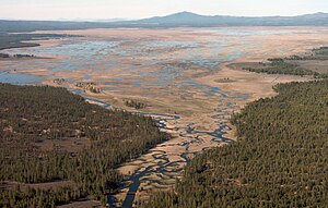
of about 50 square miles (130 km). Continuing southwest through the marsh, the river leaves Lake County and re-enters
Klamath County. Further downstream, Merritt Creek enters from the left. Meandering west and then south, the Sycan receives Blue Creek from the left, enters Sprague River Valley,
448:
Downstream of
Currier Creek, Paradise Creek enters from the left, and the Sycan turns northwest and then north, leaving Klamath County and re-entering Lake County. Slightly north of the border, Long Creek enters from the right. After turning west and southwest, the river enters Sycan Marsh, a
482:
for small brook trout, while brown trout are found only in the lower river downstream of the marsh. Rough forest roads provide access to parts of the lightly fished river. The lower 12 miles (19 km) is generally bordered by privately owned land, where permission is needed for access.
680:
The relevant map quadrangles from mouth to source are Beatty, Spodue
Mountain, Riverbed Butte Spring, Sycan Marsh West, Sycan Marsh East, Pole Butte, Riverbed Butte, Shake Butte, Harvey Creek, and Slide
853:
833:
848:
41:
838:
713:
843:
426:
356:
641:
56:
795:
780:
518:
667:
257:
185:
828:
607:
509:, and other species, offers opportunities for bird-watching. Access to the preserve is by unpaved forest roads.
523:
547:
406:
167:
486:
422:
394:
243:
226:
135:
410:
155:
414:
171:
131:
40:
791:
776:
637:
506:
84:
744:
494:
418:
239:
822:
808:
463:
111:
437:
Near its headwaters, the Sycan River, flowing west, receives
Boulder Creek from the
454:
receives Snake Creek from the left, and enters the
Sprague River north of Beatty.
498:
490:
479:
471:
467:
438:
221:
502:
475:
442:
398:
272:
259:
200:
187:
691:
585:
417:, from which it flows generally southwest to join the Sprague River near
28:
450:
402:
121:
425:. The uppermost 59 miles (95 km) of the stream are part of the
413:. The river runs northwest into the Sycan Marsh in southern
790:, 10th ed. Scappoose, Oregon: Flying Pencil Publications.
393:
is a tributary, about 75 miles (121 km) long, of the
636:. Corvallis: Oregon State University Press. p. 239.
775:, 7th ed. Portland: Oregon Historical Society Press.
788:
Fishing in Oregon: The
Complete Oregon Fishing Guide
771:
McArthur, Lewis A., and McArthur, Lewis L. (2003) .
554:. United States Geological Survey. November 28, 1980
371:
363:
354:
336:
326:
318:
306:
298:
288:
249:
232:
220:
177:
161:
150:
141:
127:
117:
107:
102:
79:
21:
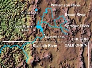
71:Location of the mouth of the Sycan River in Oregon
668:"United States Geological Survey Topographic Map"
613:. United States Forest Service. 2005. p. 2
8:
854:Oregon placenames of Native American origin
834:Wild and Scenic Rivers of the United States
661:
659:
657:
655:
653:
405:. The headwaters are in highlands in the
694:. National Wild and Scenic Rivers System
441:and the South Fork Sycan River from the
534:
542:
540:
538:
427:National Wild and Scenic Rivers System
18:
580:
578:
370:
362:
353:
7:
342:1 cu ft/s (0.028 m/s)
332:149 cu ft/s (4.2 m/s)
552:Geographic Names Information System
478:trout. The upper river offers good
310:559 sq mi (1,450 km)
63:
786:Sheehan, Madelynne Diness (2005).
14:
815:video, Oregon Public Broadcasting
666:United States Geological Survey.
588:. United States Geological Survey
519:List of longest streams of Oregon
839:Rivers of Klamath County, Oregon
608:"Lower Sycan Watershed Analysis"
62:
55:
39:
27:
849:Fremont–Winema National Forest
750:. The Nature Conservancy. 2005
586:"National Hydrography Dataset"
357:National Wild and Scenic River
251: • coordinates
179: • coordinates
16:River in Oregon, United States
1:
844:Rivers of Lake County, Oregon
142:Physical characteristics
634:Field Guide to Oregon Rivers
294:4,311 ft (1,314 m)
290: • elevation
154:south of Slide Mountain and
83:after Sycan Marsh, from the
234: • location
163: • location
870:
572:McArthur, pp. 930–31
338: • minimum
328: • average
33:Aerial view of Sycan Marsh
383:
379:
350:
346:
314:
216:
146:
50:
45:Map of Sycan River region
38:
26:
716:. The Nature Conservancy
524:List of rivers of Oregon
302:75 mi (121 km)
773:Oregon Geographic Names
407:Fremont National Forest
168:Fremont National Forest
745:"Discover Sycan Marsh"
714:"Sycan Marsh Preserve"
487:The Nature Conservancy
273:42.46111°N 121.28694°W
201:42.64722°N 120.73556°W
692:"Sycan River, Oregon"
632:Palmer, Tim (2014).
367:Scenic, Recreational
278:42.46111; -121.28694
206:42.64722; -120.73556
462:The river supports
269: /
197: /
97:level, grassy place
813:Oregon Field Guide
507:white-faced ibises
643:978-0-87071-627-0
387:
386:
861:
829:Rivers of Oregon
760:
759:
757:
755:
749:
741:
735:
732:
726:
725:
723:
721:
710:
704:
703:
701:
699:
688:
682:
679:
677:
675:
663:
648:
647:
629:
623:
622:
620:
618:
612:
604:
598:
597:
595:
593:
582:
573:
570:
564:
563:
561:
559:
544:
375:October 28, 1988
339:
329:
284:
283:
281:
280:
279:
274:
270:
267:
266:
265:
262:
212:
211:
209:
208:
207:
202:
198:
195:
194:
193:
190:
180:
164:
66:
65:
59:
43:
31:
19:
869:
868:
864:
863:
862:
860:
859:
858:
819:
818:
805:
768:
763:
753:
751:
747:
743:
742:
738:
734:Sheehan, p. 292
733:
729:
719:
717:
712:
711:
707:
697:
695:
690:
689:
685:
673:
671:
665:
664:
651:
644:
631:
630:
626:
616:
614:
610:
606:
605:
601:
591:
589:
584:
583:
576:
571:
567:
557:
555:
546:
545:
536:
532:
515:
495:sandhill cranes
460:
435:
359:
337:
327:
291:
277:
275:
271:
268:
263:
260:
258:
256:
255:
252:
235:
205:
203:
199:
196:
191:
188:
186:
184:
183:
178:
162:
75:
74:
73:
72:
69:
68:
67:
46:
34:
17:
12:
11:
5:
867:
865:
857:
856:
851:
846:
841:
836:
831:
821:
820:
817:
816:
804:
803:External links
801:
800:
799:
784:
767:
764:
762:
761:
736:
727:
705:
683:
649:
642:
624:
599:
574:
565:
533:
531:
528:
527:
526:
521:
514:
511:
459:
456:
434:
431:
423:Klamath County
385:
384:
381:
380:
377:
376:
373:
369:
368:
365:
361:
360:
355:
352:
351:
348:
347:
344:
343:
340:
334:
333:
330:
324:
323:
320:
316:
315:
312:
311:
308:
304:
303:
300:
296:
295:
292:
289:
286:
285:
253:
250:
247:
246:
244:Klamath County
236:
233:
230:
229:
224:
218:
217:
214:
213:
181:
175:
174:
165:
159:
158:
152:
148:
147:
144:
143:
139:
138:
129:
125:
124:
119:
115:
114:
109:
105:
104:
100:
99:
81:
77:
76:
70:
61:
60:
54:
53:
52:
51:
48:
47:
44:
36:
35:
32:
24:
23:
15:
13:
10:
9:
6:
4:
3:
2:
866:
855:
852:
850:
847:
845:
842:
840:
837:
835:
832:
830:
827:
826:
824:
814:
810:
807:
806:
802:
797:
796:0-916473-15-5
793:
789:
785:
782:
781:0-87595-277-1
778:
774:
770:
769:
765:
746:
740:
737:
731:
728:
715:
709:
706:
693:
687:
684:
669:
662:
660:
658:
656:
654:
650:
645:
639:
635:
628:
625:
609:
603:
600:
587:
581:
579:
575:
569:
566:
553:
549:
548:"Sycan River"
543:
541:
539:
535:
529:
525:
522:
520:
517:
516:
512:
510:
508:
504:
500:
496:
492:
488:
484:
481:
477:
473:
469:
465:
457:
455:
452:
446:
444:
440:
432:
430:
428:
424:
420:
416:
412:
408:
404:
400:
396:
395:Sprague River
392:
382:
378:
374:
366:
358:
349:
345:
341:
335:
331:
325:
321:
317:
313:
309:
305:
301:
297:
293:
287:
282:
254:
248:
245:
241:
237:
231:
228:
227:Sprague River
225:
223:
219:
215:
210:
182:
176:
173:
169:
166:
160:
157:
153:
149:
145:
140:
137:
133:
130:
126:
123:
120:
116:
113:
112:United States
110:
106:
101:
98:
94:
90:
86:
82:
78:
58:
49:
42:
37:
30:
25:
20:
812:
787:
772:
752:. Retrieved
739:
730:
718:. Retrieved
708:
698:December 19,
696:. Retrieved
686:
672:. Retrieved
633:
627:
615:. Retrieved
602:
590:. Retrieved
568:
556:. Retrieved
551:
499:yellow rails
491:tundra swans
485:
461:
447:
436:
390:
388:
96:
92:
88:
809:Sycan Marsh
766:Works cited
670:. TopoQuest
480:fly fishing
415:Lake County
411:Summer Lake
391:Sycan River
276: /
264:121°17′13″W
204: /
192:120°44′08″W
172:Lake County
156:Summer Lake
22:Sycan River
823:Categories
530:References
503:black tern
458:Recreation
399:U.S. state
372:Designated
307:Basin size
261:42°27′40″N
189:42°38′50″N
95:, meaning
681:Mountain.
409:south of
319:Discharge
80:Etymology
754:April 8,
720:April 8,
674:April 8,
617:April 7,
592:March 9,
558:April 7,
513:See also
103:Location
464:rainbow
451:wetland
397:in the
136:Klamath
108:Country
85:Klamath
794:
779:
640:
474:, and
433:Course
419:Beatty
403:Oregon
322:
299:Length
240:Beatty
151:Source
128:County
122:Oregon
87:words
811:, an
748:(PDF)
611:(PDF)
472:brown
468:brook
439:right
421:, in
238:near
222:Mouth
118:State
89:saiga
792:ISBN
777:ISBN
756:2011
722:2011
700:2013
676:2011
638:ISBN
619:2011
594:2011
560:2011
476:bull
443:left
389:The
364:Type
134:and
132:Lake
93:keni
91:and
401:of
825::
652:^
577:^
550:.
537:^
505:,
501:,
497:,
493:,
470:,
466:,
429:.
242:,
170:,
798:.
783:.
758:.
724:.
702:.
678:.
646:.
621:.
596:.
562:.
Text is available under the Creative Commons Attribution-ShareAlike License. Additional terms may apply.