63:
482:
50:
70:
330:, known as Keilor Road, was opened in 1859 and renamed Sydenham on 1 April 1887. Jock Mac Rob and Graham Homes were two of the early Station Masters ROB. The station was relocated before reopening as Watergardens in 2002, with the extension of the electric rail service to the suburb. Watergardens is on the
376:
Pioneer Park (71–79 Victoria Road
Sydenham) Totals 3.3 hectares and supports the Natural Temperate Grasslands of the Victorian Volcanic Plains. It contains one of the largest remaining catchments of Kangaroo Grass in the metropolitan Melbourne area protected by Environmental laws. Has park seating
364:
There are a number of
Churches including the Macedonian Orthodox Church "Nativity of the Holy Mother of God" which is located near the Watergardens railway station. Also, the Sydenham Baptist Church, Town Well Uniting Church, Australian Christian Churches Victoria, Assemblies of God, and a few
355:
senior high school and shares some of its grounds with Emmaus
Catholic Primary School. It also includes the Sydenham-Hillside Primary School, which is one of the country's largest government primary school and the Sydenham Campus of Copperfield College.
204:
192:
584:
62:
778:
348:
577:
99:
495:
327:
752:
311:
570:
418:
460:
197:
773:
180:
92:
221:
17:
717:
732:
722:
255:
240:
692:
687:
674:
464:
410:
315:
272:
262:
151:
737:
697:
679:
633:
304:
235:
702:
331:
296:
707:
638:
605:
424:
135:
712:
653:
648:
628:
620:
247:
230:
209:
643:
267:
666:
661:
615:
610:
594:
414:
308:
185:
40:
352:
49:
481:
544:
436:
767:
562:
377:
with unique playground equipment, sculptures, and significant native vegetation.
517:
114:
101:
300:
292:
173:
36:
439:– Sydenham was previously within this former local government area...
566:
421:. Sydenham Park Soccer Club competes in the north west state 2
303:, 22 km (14 mi) north-west of Melbourne's
203:
191:
179:
168:
160:
150:
142:
130:
91:
30:
314:. Sydenham recorded a population of 10,578 at the
326:Sydenham Post Office opened on 26 August 1861. A
334:and was a terminus station until November 2012.
216:
578:
8:
585:
571:
563:
480:
465:"Sydenham (Vic.) (Suburbs and Localities)"
427:is located just to the north of Sydenham.
48:
27:
25:Suburb of Melbourne, Victoria, Australia
449:
16:For other places called Sydenham, see
518:"Change of name of a railway station"
455:
453:
260:
245:
228:
218:
7:
349:Catholic Regional College Sydenham
14:
419:Essendon District Football League
164:3.6 km (1.4 sq mi)
69:
68:
61:
779:Suburbs of the City of Brimbank
751:territory divided with another
461:Australian Bureau of Statistics
417:football team, competes in the
1:
172:22 km (14 mi) from
398:Rose Hedge/Roseleigh Reserve
146:2,940/km (7,610/sq mi)
795:
494:Phoenix Auctions History,
15:
601:
305:Central Business District
278:
219:
215:
87:
56:
47:
18:Sydenham (disambiguation)
386:Delbridge Drive Reserve
469:2021 Census QuickStats
411:Hillside Football Club
347:The area includes the
392:Orchid Square Reserve
312:local government area
307:, located within the
774:Suburbs of Melbourne
343:Education facilities
332:Sunbury railway line
543:Full Points Footy,
425:Calder Park Raceway
395:Overton Lea Reserve
205:Federal division(s)
193:State electorate(s)
111: /
401:Stagecoach Reserve
369:Parks and Reserves
351:, a coeducational
115:37.702°S 144.767°E
761:
760:
546:Sydenham Hillside
532:– via Trove
389:Esplanade Reserve
286:
285:
282:
281:
786:
595:City of Brimbank
587:
580:
573:
564:
557:
556:
555:
553:
540:
534:
533:
531:
529:
522:The Colac Herald
514:
508:
507:
506:
504:
497:Post Office List
491:
485:
484:
479:
477:
475:
463:(28 June 2022).
457:
415:Australian Rules
309:City of Brimbank
224:around Sydenham:
217:
186:City of Brimbank
126:
125:
123:
122:
121:
120:-37.702; 144.767
116:
112:
109:
108:
107:
104:
72:
71:
65:
52:
43:
33:
28:
794:
793:
789:
788:
787:
785:
784:
783:
764:
763:
762:
757:
597:
593:Suburbs of the
591:
561:
560:
551:
549:
542:
541:
537:
527:
525:
524:, 25 March 1887
516:
515:
511:
502:
500:
493:
492:
488:
473:
471:
459:
458:
451:
446:
433:
408:
383:
374:Flagship Park:
371:
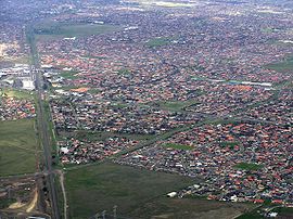
362:
345:
340:
328:railway station
324:
291:is a suburb in
143: • Density
119:
117:
113:
110:
105:
102:
100:
98:
97:
83:
82:
81:
80:
79:
78:
77:
73:
35:
34:
31:
26:
21:
12:
11:
5:
792:
790:
782:
781:
776:
766:
765:
759:
758:
744:
743:
735:
730:
725:
720:
718:Sunshine North
715:
710:
705:
700:
695:
690:
685:
677:
672:
664:
659:
651:
646:
641:
636:
631:
626:
618:
613:
608:
602:
599:
598:
592:
590:
589:
582:
575:
567:
559:
558:
535:
509:
486:
448:
447:
445:
442:
441:
440:
437:City of Keilor
432:
429:
407:
404:
403:
402:
399:
396:
393:
390:
387:
382:
379:
370:
367:
361:
358:
344:
341:
339:
336:
323:
320:
284:
283:
280:
279:
276:
275:
270:
265:
259:
258:
253:
250:
244:
243:
238:
233:
227:
226:
213:
212:
207:
201:
200:
195:
189:
188:
183:
177:
176:
170:
166:
165:
162:
158:
157:
154:
148:
147:
144:
140:
139:
132:
128:
127:
95:
89:
88:
85:
84:
75:
74:
67:
66:
60:
59:
58:
57:
54:
53:
45:
44:
24:
13:
10:
9:
6:
4:
3:
2:
791:
780:
777:
775:
772:
771:
769:
756:
755:
754:
748:
742:
739:
736:
734:
733:Taylors Lakes
731:
729:
726:
724:
723:Sunshine West
721:
719:
716:
714:
711:
709:
706:
704:
701:
699:
696:
694:
691:
689:
686:
684:
681:
678:
676:
673:
671:
668:
665:
663:
660:
658:
655:
652:
650:
647:
645:
642:
640:
637:
635:
632:
630:
627:
625:
622:
619:
617:
614:
612:
609:
607:
604:
603:
600:
596:
588:
583:
581:
576:
574:
569:
568:
565:
548:
547:
539:
536:
523:
519:
513:
510:
499:
498:
490:
487:
483:
470:
466:
462:
456:
454:
450:
443:
438:
435:
434:
430:
428:
426:
422:
420:
416:
412:
405:
400:
397:
394:
391:
388:
385:
384:
380:
378:
375:
368:
366:
359:
357:
354:
350:
342:
337:
335:
333:
329:
321:
319:
317:
313:
310:
306:
302:
298:
294:
290:
277:
274:
271:
269:
266:
264:
261:
257:
256:Taylors Lakes
254:
251:
249:
246:
242:
241:Taylors Lakes
239:
237:
234:
232:
229:
225:
223:
214:
211:
208:
206:
202:
199:
196:
194:
190:
187:
184:
182:
178:
175:
171:
167:
163:
159:
155:
153:
149:
145:
141:
137:
134:10,578 (
133:
129:
124:
96:
94:
90:
86:
64:
55:
51:
46:
42:
38:
29:
23:
19:
750:
746:
745:
740:
727:
693:Keilor North
688:Keilor Lodge
682:
675:Keilor Downs
669:
656:
623:
550:, retrieved
545:
538:
526:, retrieved
521:
512:
501:, retrieved
496:
489:
472:. Retrieved
468:
423:
409:
373:
372:
363:
346:
325:
288:
287:
273:Keilor Downs
263:Taylors Hill
220:
22:
738:Tullamarine
698:Keilor Park
680:Keilor East
634:Calder Park
316:2021 census
236:Calder Park
152:Postcode(s)
136:2023 census
118: /
106:144°46′01″E
93:Coordinates
768:Categories
703:Kings Park
444:References
131:Population
103:37°42′07″S
708:St Albans
639:Deer Park
606:Albanvale
528:16 August
301:Australia
293:Melbourne
174:Melbourne
37:Melbourne
728:Sydenham
713:Sunshine
654:Hillside
649:Derrimut
629:Cairnlea
621:Brooklyn
552:15 April
431:See also
381:Reserves
365:others.
360:Churches
353:Catholic
297:Victoria
289:Sydenham
252:Sydenham
248:Hillside
231:Hillside
198:Sydenham
169:Location
76:Sydenham
41:Victoria
32:Sydenham
644:Delahey
503:6 April
474:20 July
322:History
268:Delahey
222:Suburbs
39:,
667:Keilor
662:Kealba
616:Ardeer
611:Albion
210:Gorton
181:LGA(s)
413:, an
406:Sport
338:Today
554:2009
530:2024
505:2021
476:2022
161:Area
156:3037
753:LGA
770::
749:=
520:,
467:.
452:^
318:.
299:,
295:,
747:^
741:^
683:^
670:^
657:^
624:^
586:e
579:t
572:v
478:.
138:)
20:.
Text is available under the Creative Commons Attribution-ShareAlike License. Additional terms may apply.