293:
301:
37:
736:
229:
214:
507:
114:
468:
95:
192:
407:
was added to the state highway system in 1917. In 1927, the legislature assigned the State Route 20 designation to it, and in 1953 the west end was moved north to the present junction with
765:
606:
760:
292:
726:
665:
345:
361:
621:
175:
658:
617:
561:
62:
396:
755:
380:
373:
281:
185:
740:
180:
494:
404:
325:
269:
197:
584:
348:. SR-20 itself is a difficult route, featuring 7% grades on the approaches to the 7,910-foot (2,410 m)
682:
510:
489:
471:
257:
117:
98:
662:
479:
273:
265:
261:
333:
232:
217:
329:
717:
446:
411:, removing Little Creek Canyon Road and Upper Bear Valley Road from the state highway system.
341:
317:
260:, without directly serving or connecting any cities. It serves as a truck connection between
253:
475:
369:
321:
277:
669:
514:
451:
365:
309:
121:
102:
553:
518:
574:
Official
Highway Map, Utah Department of Transportation, 1995 edition, coordinates I-3
749:
392:
313:
140:
349:
337:
300:
635:
388:
252:) is a state highway in southern Utah, running 20.492 miles (32.979 km) in
400:
384:
408:
735:
17:
328:. Trucks are routed from I-15 and US-89 onto SR-20 in preference to
36:
299:
291:
27:
State highway in Iron and
Garfield counties in Utah, United States
725:
150:
308:
SR-20 begins at I-15, Exit 95, 14 miles (23 km) north of
352:, and oversize vehicles are required to have a pilot escort.
528:
1.000 mi = 1.609 km; 1.000 km = 0.621 mi
713:
708:
691:
20. From
Paragoonah easterly to Orton, Garfield county.
160:
146:
136:
131:
108:
89:
84:
76:
68:
55:
32:
685:(1927). "Chapter 21: Designation of State Roads".
548:
546:
544:
607:"Secondary Highways with Additional Restrictions"
80:1917 as a state highway; 1927 as SR-20–present
8:
344:. Because of this, SR-20 is included in the
324:. It ends at an intersection with US-89 at
766:Utah State Routes in Garfield County, Utah
620:- Motor Carrier Division. April 20, 2020.
418:
206:
730:
727:Template:Attached KML/Utah State Route 20
654:
652:
360:The route of SR-20 was first used by non-
312:, and heads east and southeast through a
280:. The highway follows the route of the
272:. It may also be used to travel between
540:
761:Utah State Routes in Iron County, Utah
29:
504:
498:
465:
455:
7:
624:from the original on April 10, 2009.
296:View east from the west end of SR-20
72:20.492 mi (32.979 km)
554:"Highway Reference Online - SR-20"
433:
25:
659:Utah Department of Transportation
618:Utah Department of Transportation
562:Utah Department of Transportation
484:Exit 95 on I-15; western terminus
734:
505:
466:
304:Midway along Utah State Route 20
227:
212:
112:
93:
35:
585:"Utah National Highway System"
1:
428:
364:in 1864, by the settlers of
636:"Utah History Encyclopedia"
782:
638:. University of Utah Press
336:to avoid steep grades and
270:Bryce Canyon National Park
527:
522:
501:
493:
488:
483:
460:
450:
445:
440:
437:
432:
427:
424:
421:
205:
169:Utah State Highway System
165:
156:
127:
60:
48:
50:SR-20 highlighted in red
346:National Highway System
756:State highways in Utah
683:Utah State Legislature
340:required to cross the
305:
297:
743:at Wikimedia Commons
303:
295:
731:KML is from Wikidata
687:Session Laws of Utah
672:, accessed July 2007
495:Bear Valley Junction
405:Bear Valley Junction
326:Bear Valley Junction
741:Utah State Route 20
663:State Route History
415:Major intersections
668:2007-02-25 at the
587:. UDOT Data Portal
558:maps.udot.utah.gov
372:just south of the
306:
298:
739:Media related to
533:
532:
374:Old Spanish Trail
368:. It crosses the
342:Markagunt Plateau
318:Markagunt Plateau
288:Route description
282:Old Spanish Trail
268:and an access to
258:Garfield Counties
243:
242:
239:
238:
56:Route information
16:(Redirected from
773:
738:
721:
694:
693:
679:
673:
656:
647:
646:
644:
643:
632:
626:
625:
611:
603:
597:
596:
594:
592:
581:
575:
572:
566:
565:
550:
523:Eastern terminus
509:
508:
470:
469:
435:
430:
419:
370:Tushar Mountains
362:Native Americans
322:Tushar Mountains
278:Phoenix, Arizona
235:
231:
230:
220:
216:
215:
207:
116:
115:
97:
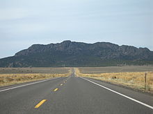
96:
39:
30:
21:
781:
780:
776:
775:
774:
772:
771:
770:
746:
745:
732:
729:
724:
723:
722:
706:
702:
697:
681:
680:
676:
670:Wayback Machine
657:
650:
641:
639:
634:
633:
629:
609:
605:
604:
600:
590:
588:
583:
582:
578:
573:
569:
552:
551:
542:
538:
529:
506:
467:
462:
457:
417:
358:
290:
228:
226:
213:
211:
113:
94:
85:Major junctions
51:
44:
43:
40:
28:
23:
22:
15:
12:
11:
5:
779:
777:
769:
768:
763:
758:
748:
747:
705:
704:
703:
701:
700:External links
698:
696:
695:
674:
648:
627:
598:
576:
567:
539:
537:
534:
531:
530:
525:
524:
521:
503:
500:
497:
492:
486:
485:
482:
480:Salt Lake City
464:
459:
454:
449:
443:
442:
439:
436:
431:
426:
423:
416:
413:
379:The road from
357:
354:
289:
286:
274:Salt Lake City
246:State Route 20
241:
240:
237:
236:
223:
221:
203:
202:
201:
200:
195:
190:
188:
183:
178:
172:
171:
163:
162:
161:Highway system
158:
157:
154:
153:
148:
144:
143:
138:
134:
133:
129:
128:
125:
124:
110:
106:
105:
91:
87:
86:
82:
81:
78:
74:
73:
70:
66:
65:
61:Maintained by
58:
57:
53:
52:
49:
46:
45:
42:State Route 20
41:
34:
33:
26:
24:
14:
13:
10:
9:
6:
4:
3:
2:
778:
767:
764:
762:
759:
757:
754:
753:
751:
744:
742:
737:
728:
719:
715:
711:
710:
699:
692:
688:
684:
678:
675:
671:
667:
664:
660:
655:
653:
649:
637:
631:
628:
623:
619:
615:
614:udot.utah.gov
608:
602:
599:
586:
580:
577:
571:
568:
563:
559:
555:
549:
547:
545:
541:
535:
526:
520:
516:
512:
496:
491:
487:
481:
477:
473:
453:
448:
444:
420:
414:
412:
410:
406:
402:
398:
394:
390:
386:
382:
377:
376:'s crossing.
375:
371:
367:
363:
355:
353:
351:
347:
343:
339:
335:
331:
327:
323:
319:
315:
311:
302:
294:
287:
285:
283:
279:
275:
271:
267:
263:
259:
255:
251:
247:
234:
224:
222:
219:
209:
208:
204:
199:
196:
194:
191:
189:
187:
184:
182:
179:
177:
174:
173:
170:
167:
166:
164:
159:
155:
152:
149:
145:
142:
141:United States
139:
135:
130:
126:
123:
119:
111:
109:East end
107:
104:
100:
92:
90:West end
88:
83:
79:
75:
71:
67:
64:
59:
54:
47:
38:
31:
19:
733:
707:
690:
686:
677:
640:. Retrieved
630:
613:
601:
589:. Retrieved
579:
570:
557:
438:Destinations
378:
359:
316:between the
307:
249:
245:
244:
168:
591:January 22,
338:switchbacks
750:Categories
642:2008-03-11
536:References
511:US 89
476:Cedar City
176:Interstate
118:US 89
18:SR-20 (UT)
515:Panguitch
452:Paragonah
399:(by 1926
393:Paragonah
383:(by 1926
366:Panguitch
310:Paragonah
122:Panguitch
103:Paragonah
709:KML file
666:Archived
622:Archived
519:Junction
513: –
490:Garfield
474: –
425:Location
320:and the
132:Location
356:History
137:Country
77:Existed
502:32.979
499:20.492
461:0.000–
456:0.000–
422:County
389:SR-271
387:, now
350:summit
198:Scenic
69:Length
610:(PDF)
463:0.261
458:0.162
441:Notes
403:) at
401:US-89
397:SR-11
391:) in
385:US-91
334:SR-14
266:US-89
250:SR-20
233:SR-21
218:SR-19
193:Minor
186:State
147:State
120:near
101:near
718:help
714:edit
593:2019
472:I-15
447:Iron
409:I-15
381:SR-1
332:and
330:SR-9
314:pass
276:and
264:and
262:I-15
256:and
254:Iron
151:Utah
99:I-15
63:UDOT
395:to
752::
716:•
689:.
661:,
651:^
616:.
612:.
560:.
556:.
543:^
517:,
478:,
434:km
429:mi
284:.
225:→
210:←
181:US
720:)
712:(
645:.
595:.
564:.
248:(
20:)
Text is available under the Creative Commons Attribution-ShareAlike License. Additional terms may apply.