27:
284:
to the northwest. Topographically it transitions into the last-named ridge seamlessly. Several streams rise within or on the edge of the
Sackwald, whose waters eventually empty into the westward-running
579:
569:
296:
The unpopulated
Sackwald is crossed by several forest tracks and hiking trails, which enable the densely forested landscape to be explored. They include the
109:
564:
526:
and north of Sack (both in the borough of Alfeld) at about 185 metres above sea level on the southwestern edge of the neighbouring
506:
Apart from the forested landscape itself, the points of interest in the
Sackwald include the ruins of a Frankish mission station on the
548:
574:
102:
297:
519:
334:
54:
511:
374:
315:
281:
214:
189:
482:
197:
160:
26:
523:
507:
515:
389:
209:
36:
544:
311:
273:
257:
234:
185:
433:
Winzenburger Bach, rises in the southern part of the
Sackwald, eastern tributary of the Leine
424:
458:
419:
349:
Hohe
Schanze (326 m) – east of Winzenburg, site of the ruins of a Frankish mission station
246:
306:
418:, passes the Sackwald a few kilometres away to the southwest, southern tributary of the
470:
452:
277:
238:
201:
141:
32:
318:
federal roads, and link, for example, Alfeld, Freden and
Lamspringe with one another.
558:
494:
415:
409:
286:
269:
242:
230:
148:
300:
path that runs through the forests and the Hohe
Schanze Historic Educational Path (
193:
427:, rises in the southeastern part of the Sackwald, southwestern tributary of the
412:, rises in the southeastern part of the Sackwald, eastern tributary of the Leine
488:
476:
327:
180:
165:
326:
Amongst the hills in the
Sackwald are the following (heights in metres above
124:
111:
446:
355:
Hainholzberg (ca. 300 m) – southwest of
Adenstedt on the boundary with the
527:
356:
290:
265:
261:
253:
218:
464:
207:
The
Sackwald is part of the geological structure of the Sack Basin or
402:
61:
449:
in the catchment area of the Riehe, north-northeast of the Sackwald
428:
485:
the village the forest was named after, northwest of the Sackwald
280:(on the other side of the Leine valley) to the southwest and the
293:; the ridge thus lies on the watershed between the two rivers.
337:(374 m) – southwest of Woltershausen and northeast of Everode
518:
on the Tiebenberg. Also worth seeing are the ruins of the
388:
Tiebenberg (ca. 240 m) – north of Winzenburg, site of the
497:
in the catchment area of the Riehe, east of the Sackwald
467:
in the catchment area of the Leine, west of the Sackwald
461:
on the Gande, a few kilometres southeast of the Sackwald
442:
Amongst the villages on the edge of the Sackwald are:
385:
Horstberg (ca. 250 m) – east-southeast of Alfeld-Hörsum
373:
Winzenberg (272 m) – northeast of Winzenburg, site of
304:). The ridge may be reached over winding state roads (
352:
Gehlenberg (ca. 315 m) – west-southwest of Lamspringe
245:
to the northwest and the rather more distant town of
159:
154:
140:
101:
93:
85:
77:
72:
60:
50:
45:
18:
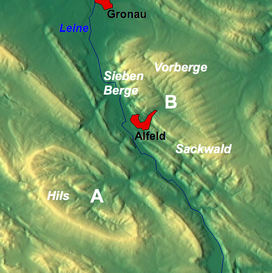
256:to the north, the southeastern foothills of the
252:The Sackwald is surrounded by the ridges of the
514:on the Winzenberg and the cultural monument of
491:on the Winzenburger Bach, south of the Sackwald
382:Feldberg (267 m) – west-southwest of Lamspringe
379:Buchenberg (270 m) – north-northwest of Everode
346:Saurenberg (321 m) – north-northwest of Everode
361:Kratzberg (ca. 300 m) – north of Alfeld-Hörsum
473:on the Leine, south-southwest of the Sackwald
229:The Sackwald lies on the eastern edge of the
8:
580:Natural regions of the Weser-Leine Uplands
15:
340:Paradiesgarten (336 m) – north of Everode
343:Teufelskirche (330 m) – north of Everode
455:on the Leine, northwest of the Sackwald
570:Forests and woodlands of Lower Saxony
370:Mullenberg (278 m) – north of Everode
7:
237:. It is located between the town of
367:Rüstiberg (288 m) – east of Everode
196:. It is named after the village of
479:on the Lamme, east of the Sackwald
364:Menteberg (300 m) – east of Alfeld
204:, the name meaning "Sack Forest".
14:
302:Historische Lehrpfad Hohe Schanze
276:to the south and southwest, the
25:
1:
192:in the North German state of
67:374 m above NN
541:Naturdenkmale Niedersachsens
405:in or on the Sackwald are:
260:to the north-northeast, the
565:Hill ranges of Lower Saxony
522:, which stand northeast of
268:to the east-northeast, the
179:374 m above
596:
539:Ernst Andreas Friedrich:
289:or the northeast flowing
23:
125:51.9666667°N 9.9166667°E
264:to the northeast, the
575:Hildesheim (district)
130:51.9666667; 9.9166667
310:) branching off the
188:in the district of
121: /
97:Hildesheim district
520:Schulenburg Chapel
502:Points of interest
249:to the southeast.
200:in the borough of
177:is a ridge, up to
46:Highest point
31:The Sackwald near
543:. Hanover, 1980,
512:Winzenburg Castle
392:cultural monument
375:Winzenburg Castle
272:to the east, the
258:Hildesheim Forest
235:Lower Saxon Hills
186:Lower Saxon Hills
171:
170:
103:Range coordinates
587:
183:
144:
136:
135:
133:
132:
131:
126:
122:
119:
118:
117:
114:
68:
29:
16:
595:
594:
590:
589:
588:
586:
585:
584:
555:
554:
536:
510:, the ruins of
504:
459:Bad Gandersheim
440:
399:
324:
247:Bad Gandersheim
227:
213:along with the
178:
142:
129:
127:
123:
120:
115:
112:
110:
108:
107:
66:
41:
40:
35:as part of the
12:
11:
5:
593:
591:
583:
582:
577:
572:
567:
557:
556:
553:
552:
535:
532:
503:
500:
499:
498:
492:
486:
480:
474:
468:
462:
456:
450:
439:
436:
435:
434:
431:
422:
413:
398:
395:
394:
393:
386:
383:
380:
377:
371:
368:
365:
362:
359:
353:
350:
347:
344:
341:
338:
328:sea level (NN)
323:
320:
226:
223:
181:sea level (NN)
169:
168:
163:
157:
156:
152:
151:
146:
138:
137:
105:
99:
98:
95:
91:
90:
87:
83:
82:
79:
75:
74:
70:
69:
64:
58:
57:
52:
48:
47:
43:
42:
30:
24:
21:
20:
13:
10:
9:
6:
4:
3:
2:
592:
581:
578:
576:
573:
571:
568:
566:
563:
562:
560:
550:
549:3-7842-0227-6
546:
542:
538:
537:
533:
531:
529:
525:
521:
517:
513:
509:
501:
496:
495:Woltershausen
493:
490:
487:
484:
483:Sack (Alfeld)
481:
478:
475:
472:
469:
466:
463:
460:
457:
454:
451:
448:
445:
444:
443:
437:
432:
430:
426:
423:
421:
417:
414:
411:
408:
407:
406:
404:
396:
391:
387:
384:
381:
378:
376:
372:
369:
366:
363:
360:
358:
354:
351:
348:
345:
342:
339:
336:
333:
332:
331:
329:
321:
319:
317:
313:
309:
308:
307:Landesstraßen
303:
299:
294:
292:
288:
283:
279:
275:
271:
267:
263:
259:
255:
250:
248:
244:
240:
236:
232:
231:Leine Uplands
224:
222:
220:
216:
212:
211:
205:
203:
199:
195:
191:
187:
184:high, in the
182:
176:
167:
164:
162:
158:
153:
150:
149:Leine Uplands
147:
145:
139:
134:
106:
104:
100:
96:
92:
88:
84:
80:
76:
71:
65:
63:
59:
56:
53:
49:
44:
38:
34:
28:
22:
17:
540:
524:Langenholzen
508:Hohe Schanze
505:
441:
401:Amongst the
400:
325:
305:
301:
295:
282:Sieben Berge
251:
228:
215:Sieben Berge
208:
206:
194:Lower Saxony
174:
172:
143:Parent range
89:Lower Saxony
397:Waterbodies
243:River Leine
161:Age of rock
128: /
559:Categories
516:Tiebenburg
489:Winzenburg
477:Lamspringe
390:Tiebenburg
335:Ahrensberg
190:Hildesheim
166:Cretaceous
113:51°58′00″N
55:Ahrensberg
447:Adenstedt
298:Rennstieg
274:Helleberg
225:Geography
210:Sackmulde
116:9°55′00″E
73:Geography
62:Elevation
37:Sackmulde
528:Vorberge
438:Villages
357:Vorberge
291:Innerste
266:Harplage
262:Sauberge
254:Vorberge
219:Vorberge
217:and the
175:Sackwald
94:District
19:Sackwald
534:Sources
465:Everode
403:streams
241:on the
233:in the
155:Geology
81:Germany
78:Country
547:
471:Freden
453:Alfeld
278:Selter
239:Alfeld
202:Alfeld
33:Alfeld
429:Lamme
425:Riehe
420:Aller
416:Leine
410:Gande
322:Hills
287:Leine
270:Heber
86:State
545:ISBN
330:):
316:B 64
314:and
198:Sack
173:The
51:Peak
312:B 3
39:(B)
561::
530:.
221:.
551:.
Text is available under the Creative Commons Attribution-ShareAlike License. Additional terms may apply.