20:
27:
363:
185:
as gravel, blocked the southerly course of the
Saalach and force it to flow northwards along its present riverbed. This has been evinced by excavations between
407:
437:
177:(875 m). In the post-glacial period, the Saalach flowed into the Zeller See and then into the Salzach river to the south. The
412:
322:
422:
171:
debris about 10,000 years ago that extend from the Zeller See in the north to just in front of
Saalfelden, roughly by the
442:
167:
The
Saalach Valley was formed by the Salzach-Saalach Glacier. When it retreated the glacier left behind thick sheets of
417:
402:
19:
190:
432:
274:
186:
221: (B 178) as far as the Austro-German border. In Bavaria the line of the valley is followed by the
427:
89:
238:
233:
223:
77:
105:
203:
117:
109:
217:
294:
173:
101:
93:
309:
133:
49:
396:
178:
113:
61:
125:
208:
155:
129:
121:
342:"Saalacherlebniswelt: Vom Ursprung bis zur Mündung - Ein Natur- and Kulturraum"
378:
365:
280:
Saalacherlebniswelt. Vom
Ursprung bis zur Mündung - Ein Natur- and Kulturraum
275:"Vom eiszeitlichen Urtal zum heutigen Föhntal: Oberes Saalachtal im Pinzgau"
182:
143:
The roughly 30 km long upper reaches of the
Saalach is not called the
136:, the Saalach flowing for its last few kilometres through the plain of the
168:
149:
69:
73:
65:
57:
341:
279:
228:
212:
181:
from the
Glemmtal, that were laid down between the Zeller See and
88:
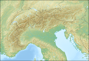
The main valley is about 70 km long and begins north of the
104:
in the west, from where the
Saalach originates, from the
207: (B 311) runs through the Saalach Valley from
72:
regions) and the southern part of the German state of
56:) is the name of the middle and upper reaches of the
257:. K. K. Hof- u. Staatsdruckerei, Wien 1912.
153:, the area of its source streams being called
8:
60:, a mountain river in the Austrian state of
128:the valley broadens again and ends between
266:
304:
303:
292:
255:Das Saalachtalbahn-Projekt. Juni 1912
7:
325:Österreichischer Bibliothekenverbund
408:Valleys of Salzburg (federal state)
215:followed by a short section of the
108:in the east; later, it divides the
100:region. Initially it separates the
26:
14:
92:. It forms the broad vale of the
438:Loferer and Leoganger Steinberge
25:
18:
1:
237:. This route is known as the
459:
138:Salzburg-Freilassing Basin
197:Tributaries and transport
413:Northern Limestone Alps
84:Course and countryside
53:
243:Kleines Deutsches Eck
147:, but bears the name
116:in the west from the
423:Berchtesgadener Land
239:Little German Corner
234:Bundesstraße 20
224:Bundesstraße 21
78:Berchtesgadener Land
443:Salzburg Slate Alps
375: /
106:Salzburg Slate Alps
96:, the heart of the
418:Berchtesgaden Alps
403:Valleys of Bavaria
120:in the east. Near
118:Berchtesgaden Alps
110:Loferer Steinberge
379:47.533°N 12.733°E
302:External link in
39:Saalachtal (Alps)
450:
390:
389:
387:
386:
385:
380:
376:
373:
372:
371:
368:
351:
349:
348:
329:
320:
314:
313:
307:
306:
300:
298:
290:
288:
287:
271:
94:Saalfelden Basin
29:
28:
22:
458:
457:
453:
452:
451:
449:
448:
447:
393:
392:
383:
381:
377:
374:
369:
366:
364:
362:
361:
360:
358:
346:
344:
340:
337:
332:
321:
317:
301:
291:
285:
283:
273:
272:
268:
264:
251:
199:
165:
86:
42:
41:
40:
37:
36:
35:
34:
30:
12:
11:
5:
456:
454:
446:
445:
440:
435:
433:Kitzbühel Alps
430:
425:
420:
415:
410:
405:
395:
394:
384:47.533; 12.733
357:
354:
353:
352:
336:
335:External links
333:
331:
330:
315:
265:
263:
260:
259:
258:
250:
247:
211:to just after
198:
195:
179:drift deposits
164:
161:
102:Kitzbühel Alps
98:Saalachpinzgau
85:
82:
46:Saalach Valley
38:
32:
31:
24:
23:
17:
16:
15:
13:
10:
9:
6:
4:
3:
2:
455:
444:
441:
439:
436:
434:
431:
429:
428:Chiemgau Alps
426:
424:
421:
419:
416:
414:
411:
409:
406:
404:
401:
400:
398:
391:
388:
355:
343:
339:
338:
334:
327:
326:
319:
316:
311:
296:
282:
281:
276:
270:
267:
261:
256:
253:
252:
248:
246:
244:
240:
236:
235:
230:
226:
225:
220:
219:
214:
210:
206:
205:
196:
194:
192:
188:
184:
180:
176:
175:
170:
162:
160:
159:
157:
152:
151:
146:
141:
139:
135:
131:
127:
123:
119:
115:
114:Chiemgau Alps
111:
107:
103:
99:
95:
91:
83:
81:
79:
75:
71:
67:
63:
59:
55:
51:
47:
21:
359:
345:. Retrieved
324:
318:
284:. Retrieved
278:
269:
254:
242:
232:
222:
216:
204:Pinzgau Road
202:
200:
172:
166:
154:
148:
144:
142:
137:
97:
87:
45:
43:
382: /
305:|work=
209:Zell am See
156:Hinterglemm
130:Freilassing
122:Reichenhall
397:Categories
347:2010-11-27
323:Permalink
286:2010-11-27
262:References
227:and, from
218:Lofer Road
145:Saalachtal
90:Zeller See
54:Saalachtal
33:Saalachtal
191:Unterreit
183:Maishofen
126:Großgmain
112:and the
295:cite web
174:Kühbichl
169:morainic
150:Glemmtal
134:Salzburg
70:Flachgau
62:Salzburg
370:12°44′E
367:47°32′N
249:Sources
163:Geology
74:Bavaria
66:Pinzgau
58:Saalach
231:, the
229:Piding
187:Atzing
50:German
356:Notes
213:Lofer
310:help
201:The
189:and
132:and
124:and
76:(in
68:and
44:The
245:).
80:).
399::
299::
297:}}
293:{{
277:.
193:.
140:.
52::
350:.
328:.
312:)
308:(
289:.
241:(
158:.
64:(
48:(
Text is available under the Creative Commons Attribution-ShareAlike License. Additional terms may apply.