154:
194:
161:
187:
441:
768:
397:
40:
432:). As a result, the west side of the North Cascades experiences high precipitation, especially during the winter months in the form of snowfall. During winter months, weather is usually cloudy, but, due to high pressure systems over the Pacific Ocean that intensify during summer months, there is often little or no cloud cover during the summer.
367:
3–4 climb to the summit. Another option is to traverse from the Sahale Arm onto the Quien Sabe
Glacier and climb the glacier to the rock ridge north of the peak. The climb up this ridge is also class 3–4 but crosses some loose rock and is more
508:
period dating back over two million years ago, glaciation advancing and retreating repeatedly scoured the landscape leaving deposits of rock debris. The U-shaped cross section of the river valleys is a result of recent glaciation.
767:
756:
362:
Sahale Peak is noted for its panoramic views and is popular among mountaineers. The least technical route follows the Sahale Arm from the
Cascade Pass Trail to the Sahale Glacier. From the glacier there is a
109:
466:
spires. Geological events occurring many years ago created the diverse topography and drastic elevation changes over the
Cascade Range leading to various climate differences.
806:
791:
801:
153:
350:
east of this ridge and above
Horseshoe Basin. Sahale Glacier is south of the summit and east of Sahale Arm, a ridge that extends southwest from Sahale to
186:
796:
571:
428:, they are forced upward by the peaks of the Cascade Range, causing them to drop their moisture in the form of rain or snowfall onto the Cascades (
517:
in combination with glaciation have been the dominant processes which have created the tall peaks and deep valleys of the North
Cascades area.
562:
777:
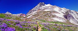
Panoramic view from the top of Sahale Arm at sunset. Summits include
Bonanaza Peak, Mount Formidable, The Triplets, and Cascade Peak.
607:
719:
567:
262:
774:
739:
319:
223:
102:
369:
354:. The name Sahale may originate from a Northwest Native American word meaning "high place," "falcon," or "sacred."
231:
227:
557:
599:
490:
377:
364:
323:
299:
236:
62:
80:
70:
92:
671:
Beckey, Fred W. Cascade Alpine Guide, Climbing and High Routes. Seattle, WA: Mountaineers Books, 2008.
593:
474:
381:
486:
469:
The history of the formation of the
Cascade Mountains dates back millions of years ago to the late
281:
339:
603:
448:
421:
405:
343:
295:
655:
731:
723:
641:
514:
440:
429:
257:
498:
459:
444:
425:
385:
250:
243:
396:
785:
478:
455:
417:
413:
409:
335:
373:
351:
303:
288:
275:
588:
505:
331:
85:
539:
747:
124:
111:
17:
707:
623:
39:
510:
494:
482:
463:
315:
454:
The North
Cascades features some of the most rugged topography in the
470:
347:
55:
338:
between the two is 80 feet (24 m) lower than Sahale's summit.
395:
380:
to the west or from the east, it is accessible via a trail, from
330:. It is 0.3 miles (0.48 km) south of its higher neighbor,
342:
is to the west of the ridge between the two peaks while
326:
state. The summit of Sahale
Mountain is referred to as
667:
665:
447:, Boston Peak, Sahale, Quien Sabe Glacier seen from
287:
274:
269:
256:
242:
219:
140:
101:
91:
79:
69:
54:
49:
32:
485:persisted. In addition, small fragments of the
27:Mountain in Washington (state), United States
8:
683:
681:
679:
677:
690:The Natural History of Puget Sound Country
29:
583:
581:
572:United States Department of the Interior
439:
526:
376:and the Sahale Arm can be reached from
193:
160:
807:Mountains of Skagit County, Washington
792:Mountains of Chelan County, Washington
7:
802:North Cascades of Washington (state)
596:, Vol. 3, Rainy Pass to Fraser River
534:
532:
530:
563:Geographic Names Information System
458:with craggy peaks and ridges, deep
206:Sahale Mountain (the United States)
420:, and travel northeast toward the
25:
692:. University of Washington Press.
280:August 1897 by John Charlton and
766:
192:
185:
159:
152:
38:
797:Mountains of Washington (state)
722:. Alpine Ascent. Archived from
568:United States Geological Survey
400:Sahale and Sahale Arm in winter
176:Show map of Washington (state)
1:
209:Show map of the United States
501:about 50 million years ago.
320:North Cascades National Park
224:North Cascades National Park
44:Sahale Arm below Sahale Peak
688:Kruckeberg, Arthur (1991).
656:"Sahale Peak Rock Climbing"
97:0.34 mi (0.55 km)
823:
658:. Adventure Projects, Inc.
125:48.4912382°N 121.0390017°W
759:. Google Earth Community.
540:"Sahale Peak, Washington"
483:volcanic igneous activity
424:. As fronts approach the
404:Sahale is located in the
145:
37:
408:climate zone of western
130:48.4912382; -121.0390017
491:continental lithosphere
734:. ClimbWashington.com.
451:
401:
173:Location in Washington
75:80 ft (20 m)
644:. Sahale Snacks, Inc.
443:
399:
602:. pp. 330–331.
594:Cascade Alpine Guide
475:North American Plate
60:8,680+ ft (2,650+ m)
282:Albert H. Sylvester
121: /
600:Mountaineers Books
452:
402:
340:Quien Sabe Glacier
63: NGVD 29
50:Highest point
757:"Sahale Mountain"
740:"Sahale Mountain"
720:"Sahale Mountain"
708:"Sahale Mountain"
624:"Sahale Mountain"
558:"Sahale Mountain"
449:Hidden Lake Peaks
422:Cascade Mountains
416:originate in the
406:marine west coast
344:Davenport Glacier
309:
308:
65:
16:(Redirected from
814:
770:
760:
751:
746:. Archived from
735:
727:
715:
694:
693:
685:
672:
669:
660:
659:
652:
646:
645:
638:
632:
631:
620:
614:
613:
598:(3rd ed.).
585:
576:
575:
554:
548:
547:
536:
473:Epoch. With the
291:
246:
237:Washington, U.S.
210:
196:
195:
189:
177:
163:
162:
156:
136:
135:
133:
132:
131:
126:
122:
119:
118:
117:
114:
61:
42:
30:
21:
822:
821:
817:
816:
815:
813:
812:
811:
782:
781:
780:
779:
778:
776:
771:
754:
738:
730:
718:
706:
703:
698:
697:
687:
686:
675:
670:
663:
654:
653:
649:
640:
639:
635:
622:
621:
617:
610:
589:Beckey, Fred W.
587:
586:
579:
556:
555:
551:
538:
537:
528:
523:
477:overriding the
460:glacial valleys
438:
430:Orographic lift
394:
360:
312:Sahale Mountain
289:
244:
235:
226:
215:
214:
213:
212:
211:
208:
207:
204:
203:
202:
201:
200:Sahale Mountain
197:
180:
179:
178:
175:
174:
171:
170:
169:
168:
167:Sahale Mountain
164:
129:
127:
123:
120:
115:
112:
110:
108:
107:
45:
33:Sahale Mountain
28:
23:
22:
15:
12:
11:
5:
820:
818:
810:
809:
804:
799:
794:
784:
783:
773:
772:
765:
764:
763:
762:
761:
752:
750:on 2016-03-04.
736:
728:
726:on 2013-01-16.
716:
712:SummitPost.org
702:
701:External links
699:
696:
695:
673:
661:
647:
633:
628:SummitPost.org
615:
608:
577:
549:
544:Peakbagger.com
525:
524:
522:
519:
499:North Cascades
481:, episodes of
445:Sharkfin Tower
437:
434:
426:North Cascades
414:weather fronts
393:
390:
386:Stehekin River
359:
356:
322:, in northern
307:
306:
300:class 3–4
293:
285:
284:
278:
272:
271:
267:
266:
260:
254:
253:
251:North Cascades
248:
240:
239:
221:
217:
216:
205:
199:
198:
191:
190:
184:
183:
182:
181:
172:
166:
165:
158:
157:
151:
150:
149:
148:
147:
146:
143:
142:
138:
137:
105:
99:
98:
95:
89:
88:
83:
77:
76:
73:
67:
66:
58:
52:
51:
47:
46:
43:
35:
34:
26:
24:
14:
13:
10:
9:
6:
4:
3:
2:
819:
808:
805:
803:
800:
798:
795:
793:
790:
789:
787:
775:
769:
758:
755:Lewis, Josh.
753:
749:
745:
741:
737:
733:
732:"Sahale Peak"
729:
725:
721:
717:
713:
709:
705:
704:
700:
691:
684:
682:
680:
678:
674:
668:
666:
662:
657:
651:
648:
643:
637:
634:
629:
625:
619:
616:
611:
609:1-59485-136-0
605:
601:
597:
595:
590:
584:
582:
578:
573:
569:
565:
564:
559:
553:
550:
545:
541:
535:
533:
531:
527:
520:
518:
516:
512:
507:
502:
500:
496:
492:
488:
484:
480:
479:Pacific Plate
476:
472:
467:
465:
461:
457:
456:Cascade Range
450:
446:
442:
435:
433:
431:
427:
423:
419:
418:Pacific Ocean
415:
411:
410:North America
407:
398:
391:
389:
387:
383:
379:
375:
371:
366:
357:
355:
353:
349:
345:
341:
337:
333:
329:
325:
321:
318:mountain, in
317:
314:is a jagged,
313:
305:
301:
297:
294:
292:
290:Easiest route
286:
283:
279:
277:
273:
268:
264:
261:
259:
255:
252:
249:
247:
241:
238:
233:
229:
225:
222:
218:
188:
155:
144:
139:
134:
106:
104:
100:
96:
94:
90:
87:
84:
82:
78:
74:
72:
68:
64:
59:
57:
53:
48:
41:
36:
31:
19:
748:the original
744:Peakware.com
743:
724:the original
711:
689:
650:
636:
627:
618:
592:
561:
552:
543:
503:
497:created the
468:
453:
403:
374:Cascade Pass
361:
352:Cascade Pass
327:
311:
310:
304:Cascade Pass
276:First ascent
265:Cascade Pass
245:Parent range
506:Pleistocene
504:During the
378:Marblemount
332:Boston Peak
328:Sahale Peak
128: /
116:121°02′20″W
103:Coordinates
86:Boston Peak
81:Parent peak
18:Sahale Peak
786:Categories
521:References
334:, and the
324:Washington
113:48°29′28″N
71:Prominence
384:, up the
316:glaciated
141:Geography
93:Isolation
56:Elevation
591:(2008).
515:faulting
495:terranes
388:valley.
382:Stehekin
358:Climbing
346:is in a
270:Climbing
258:Topo map
234:counties
220:Location
493:called
487:oceanic
464:granite
436:Geology
412:. Most
392:Climate
370:exposed
302:, from
606:
511:Uplift
471:Eocene
462:, and
348:cirque
336:saddle
232:Skagit
228:Chelan
642:"FAQ"
365:class
296:Climb
604:ISBN
513:and
489:and
263:USGS
788::
742:.
710:.
676:^
664:^
626:.
580:^
570:,
566:.
560:.
542:.
529:^
372:.
298:,
230:/
714:.
630:.
612:.
574:.
546:.
20:)
Text is available under the Creative Commons Attribution-ShareAlike License. Additional terms may apply.