434:
399:. Erected at the exit of the lake in 1934, it was replaced in 1948 and the lake raised again. As a result of this dam, the surrounding lowlands were submerged over widths up to 50 metres (160 ft). Today, the lake level is higher than it was originally about 2 metres (6 ft 7 in). This impoundment therefore upset the physical and biological balance by modifying the morphometry of the lake, bringing a massive supply of sediment and periodically creating a significant deficit in
60:
351:
47:
446:
67:
341:
The surface of Lake Saint-Charles is generally frozen from the beginning of
December to the end of March; safe circulation on the ice is generally done from the end of December to the beginning of March.
414:
are offered to discover the lake and many people take advantage of it every year. The rental of boats (canoes, kayaks, rowboats, pedal boats) is also possible, whether for hiking or for fishing
338:
Lac Saint-Charles is served on the east side mainly by the Grande Ligne road and on the west side by the Lac-Saint-Charles road for the needs of recreational tourism and forestry.
422:
598:
490:
156:
395:
raises the level of Lake Saint-Charles because it constitutes the reservoir for the water supply of the drinking water treatment plant in the city of
106:
407:, was detected. The causes of this phenomenon are currently being studied, but actions have already been taken to limit phosphorus supplies.
309:
59:
155:(Sens horaire, à partir de l'embouchure) Ruisseau de la Courte Botte, ruisseau Talbot (via la Baie Charles-Talbot), décharge du Lac Delage,
661:
366:
31:
656:
514:
433:
403:
over half of the water column. A new problem appeared at Lake Saint-Charles in the fall of 2006 when the presence of blue algae, or
320:
171:
534:
323:. Located less than 20 minutes from downtown Quebec City, it is an important natural habitat to Quebec City area residents.
602:
530:, formerly of the Association for the Protection of the Environment of Lake Saint-Charles and the Northern Marshes (APEL)
418:. In addition, a few sites near the lake have strong archaeological potential, notably in the Charles-Talbot bay sector.
449:
625:
581:
328:
392:
370:
313:
305:
262:
560:
164:
563:. Association pour la protection de l’environnement du lac Saint-Charles et des Marais du Nord (APEL)
378:
374:
324:
293:
148:
88:
496:
354:
350:
594:
281:
477:
382:
332:
188:
178:
650:
438:
415:
404:
396:
362:
138:
533:
Brodeur, C., F. Lewis, E. Huet-Alegre, Y. Ksouri, M.-C. Leclerc and D. Viens. 2007.
457:
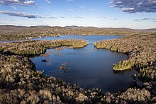
Shape: Lake Saint-Charles has two pools (north and south) giving it a shape of "8"
17:
301:
258:
46:
629:
121:
108:
445:
410:
Lake Saint-Charles has good recreational tourism potential. Guided hikes in
411:
149:
165:
400:
297:
92:
463:
Maximum length: 5.5 kilometres (3.4 mi) in a north–south axis
444:
432:
349:
541:
289:
537:
Saint-Charles river basin council. 216 p + 9 annexes 217-340 pp
466:
Maximum depth: 17.5 metres (57 ft) (in its northern basin)
389:
460:
Lake area: 3.6 square kilometres (1.4 sq mi)
527:
268:
254:
250:
242:
234:
226:
218:
210:
202:
198:
187:
177:
163:
147:
137:
98:
84:
39:
423:Linear park of the Saint-Charles and Berger rivers
373:, are the municipalities bordering the lake. The
99:
582:Open Street Map - Accessed on February 15, 2020
238:14,810,000 m (523,000,000 cu ft)
300:, Canada. It is located partially within the
8:
480:: 170 square kilometres (66 sq mi)
540:Nautical Club of Lac-Saint-Charles website
535:Portrait of the Saint-Charles river basin.
66:
36:
319:Lake Saint-Charles is the source of the
308:(section West) and partially within the
552:
421:The lake is the starting point of the
626:"nautical Club of Saint-Charles Lake"
437:The Saint-Charles Lake circa 1800 by
7:
183:167.7 km (64.7 sq mi)
30:For places with similar names, see
214:1.2 km (0.46 sq mi)
32:Lac-Saint-Charles (disambiguation)
25:
331:also administer a portion of its
222:3.6 km (1.4 sq mi)
206:5.5 km (2.1 sq mi)
450:Nature reserve of Marais-du-Nord
65:
58:
45:
241:
233:
225:
217:
209:
201:
369:, and the united townships of
1:
381:also administers part of its
246:150.42 m (493.5 ft)
83:
310:united township municipality
662:Lakes of Capitale-Nationale
601:(in French). Archived from
678:
29:
593:Town hall of the city of
53:
44:
657:Landforms of Quebec City
230:16.5 m (54 ft)
561:"Le lac Saint-Charles"
453:
442:
371:Stoneham-et-Tewkesbury
367:La Haute-Saint-Charles
358:
314:Stoneham-et-Tewkesbury
306:La Haute-Saint-Charles
285:
263:Stoneham-et-Tewkesbury
27:Lake in Quebec, Canada
448:
436:
353:
122:46.94111°N 71.38722°W
365:, by the borough of
515:Saint-Charles River
377:and the borough of
327:and the borough of
321:Saint-Charles River
172:Saint-Charles River
127:46.94111; -71.38722
118: /
491:rivière des Hurons
454:
443:
359:
294:Capitale-Nationale
278:Lake Saint-Charles
157:rivière des Hurons
89:Capitale-Nationale
73:Lake Saint-Charles
40:Lake Saint-Charles
18:Saint-Charles Lake
504:Short-boot stream
286:Lac Saint-Charles
275:
274:
243:Surface elevation
16:(Redirected from
669:
641:
640:
638:
637:
628:. Archived from
622:
616:
614:
612:
610:
590:
584:
579:
573:
572:
570:
568:
557:
472:
316:(section East).
167:
166:Primary outflows
151:
133:
132:
130:
129:
128:
123:
119:
116:
115:
114:
111:
101:
69:
68:
62:
49:
37:
21:
677:
676:
672:
671:
670:
668:
667:
666:
647:
646:
645:
644:
635:
633:
624:
623:
619:
608:
606:
592:
591:
587:
580:
576:
566:
564:
559:
558:
554:
549:
523:
511:
495:Discharge from
487:
473:of cubic meters
470:
431:
355:Bird's eye-view
348:
292:located in the
191: countries
150:Primary inflows
126:
124:
120:
117:
112:
109:
107:
105:
104:
80:
79:
78:
77:
76:
75:
74:
70:
35:
28:
23:
22:
15:
12:
11:
5:
675:
673:
665:
664:
659:
649:
648:
643:
642:
617:
605:on 11 May 2009
585:
574:
551:
550:
548:
545:
544:
543:
538:
531:
522:
521:External links
519:
518:
517:
510:
507:
506:
505:
502:
499:
493:
486:
483:
482:
481:
474:
467:
464:
461:
458:
430:
427:
393:Cyrille-Delage
347:
344:
333:drainage basin
273:
272:
270:
266:
265:
256:
252:
251:
248:
247:
244:
240:
239:
236:
232:
231:
228:
224:
223:
220:
216:
215:
212:
208:
207:
204:
200:
199:
196:
195:
192:
185:
184:
181:
179:Catchment area
175:
174:
169:
161:
160:
153:
145:
144:
141:
135:
134:
102:
96:
95:
86:
82:
81:
72:
71:
64:
63:
57:
56:
55:
54:
51:
50:
42:
41:
26:
24:
14:
13:
10:
9:
6:
4:
3:
2:
674:
663:
660:
658:
655:
654:
652:
632:on 2014-06-25
631:
627:
621:
618:
604:
600:
596:
589:
586:
583:
578:
575:
562:
556:
553:
546:
542:
539:
536:
532:
529:
525:
524:
520:
516:
513:
512:
508:
503:
500:
498:
494:
492:
489:
488:
484:
479:
475:
468:
465:
462:
459:
456:
455:
451:
447:
440:
439:George Heriot
435:
428:
426:
424:
419:
417:
416:northern pike
413:
408:
406:
405:cyanobacteria
402:
398:
394:
391:
386:
384:
380:
376:
372:
368:
364:
356:
352:
345:
343:
339:
336:
334:
330:
326:
322:
317:
315:
311:
307:
303:
299:
295:
291:
287:
283:
279:
271:
267:
264:
260:
257:
253:
249:
245:
237:
229:
221:
213:
205:
197:
193:
190:
186:
182:
180:
176:
173:
170:
168:
162:
158:
154:
152:
146:
142:
140:
136:
131:
103:
97:
94:
90:
87:
61:
52:
48:
43:
38:
33:
19:
634:. Retrieved
630:the original
620:
607:. Retrieved
603:the original
588:
577:
567:21 September
565:. Retrieved
555:
501:Talbot Creek
476:Area of the
420:
409:
387:
379:Charlesbourg
361:The town of
360:
340:
337:
329:Charlesbourg
318:
277:
276:
235:Water volume
219:Surface area
485:Tributaries
357:of the lake
304:borough of
302:Quebec City
259:Quebec City
255:Settlements
203:Max. length
125: /
100:Coordinates
651:Categories
636:2020-02-15
547:References
497:lac Delage
375:Lac-Delage
325:Lac-Delage
296:region of
269:References
227:Max. depth
211:Max. width
113:71°23′14″W
110:46°56′28″N
609:18 August
478:watershed
383:watershed
346:Geography
597:(2008).
526:Site of
509:See also
469:Volume:
429:Features
143:Dam lake
85:Location
412:rabaska
288:) is a
595:Québec
401:oxygen
397:Quebec
363:Quebec
298:Quebec
282:French
194:Canada
93:Quebec
599:"Eau"
528:Agiro
189:Basin
611:2018
569:2013
388:The
290:lake
139:Type
390:dam
312:of
653::
471:15
425:.
385:.
335:.
284::
261:,
91:,
639:.
615:.
613:.
571:.
452:.
441:.
280:(
159:.
34:.
20:)
Text is available under the Creative Commons Attribution-ShareAlike License. Additional terms may apply.