51:
372:
69:
259:
ORDNANCE SURVEY, GOVERNMENT OF THE UNITED KINGDOM, 1984, Nevis, with part of St. Christopher (Saint Kitts). Series E803 (D.O.S. 343), Sheet NEVIS, Edition 5 O.S.D. 1984. Reprinted in 1995, published by the
Government of the United Kingdom (Ordnance Survey) for the Government of Saint Christopher (St.
173:
All the Nevis parishes were drawn up to include a segment of Nevis Peak itself, but this parish also includes a secondary peak at 1901 feet, which is unnamed on the
Ordnance Survey map, but which is locally known as "Butlers Peak" because it is near the village of Butlers. The parish also includes an
178:
core called Round Hill and a smaller coastal core called
Hurricane Hill. The northern coast of Saint James Parish has several long sandy beaches: Lover's Beach, Newcastle Beach and Long Haul Bay. The more easterly part however is mostly rocky coast. Behind Butler's peak, there is flourishing rain
158:
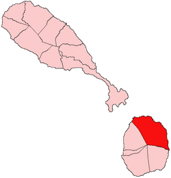
In terms of land area, Saint James is the largest in Saint Kitts and Nevis, but it is also one of the least populated, as it is mainly consisting of small communities separated by larger areas of dry
296:
50:
289:
215:
461:
422:
282:
268:
227:
59:
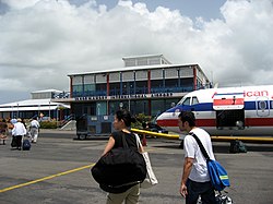
155:, which is next to the Nevis airport. Not far east from Newcastle is the hotel Nisbet Plantation Beach Club, and the Newcastle Pottery.
371:
186:
356:
321:
305:
137:
41:
152:
87:
55:
388:
331:
167:
403:
361:
351:
326:
346:
336:
408:
398:
341:
203:
141:
162:. The villages in this parish include Newcastle, Rawlins, Mount Lily, Fountain, Camps, Burnaby, Hicks,
198:
247:
193:
466:
455:
274:
17:
313:
68:
163:
437:
424:
183:
159:
147:
Saint James Parish is located in the northeastern section of the island of
175:
380:
148:
133:
136:. These five parishes are in turn part of the 14 administrative
278:
182:
At the southern end of the parish there are extensive colonial
263:
ROBINSON, DAVID & JENNIFER LOWERY (editors), 2000.
379:
312:
119:
111:
106:
98:
93:
83:
75:
32:
132:is the largest of five parishes on the island of
250:. Department of Statistics, St. Kitts and Nevis.
290:
8:
297:
283:
275:
265:The Natural History of the Island of Nevis
216:Medical University of the Americas – Nevis
29:
269:Nevis Historical and Conservation Society
239:
105:
92:
82:
74:
65:
47:
118:
110:
97:
7:
228:Vance W. Amory International Airport
60:Vance W. Amory International Airport
25:
462:Parishes of Saint Kitts and Nevis
306:Parishes of Saint Kitts and Nevis
370:
67:
49:
102:32 km (12 sq mi)
27:Parish in Saint Kitts and Nevis
1:
140:making up the Federation of
483:
357:Saint Thomas Middle Island
322:Christ Church Nichola Town
151:and the parish capital is
368:
66:
48:
39:
271:Press, Ithaca, New York.
389:Saint George Gingerland
332:Saint George Basseterre
404:Saint Paul Charlestown
362:Trinity Palmetto Point
352:Saint Peter Basseterre
327:Saint Anne Sandy Point
123:64/km (170/sq mi)
438:17.17500°N 62.56556°W
347:Saint Paul Capisterre
337:Saint John Capisterre
142:Saint Kitts and Nevis
79:Saint Kitts and Nevis
409:Saint Thomas Lowland
394:Saint James Windward
130:Saint James Windward
120: • Density
34:Saint James Windward
18:Saint James Windward
443:17.17500; -62.56556
434: /
204:Coconut Walk Estate
399:Saint John Figtree
174:ancient weathered
112: • Total
99: • Total
417:
416:
260:Kitts) and Nevis.
194:Eden Brown Estate
166:, Whitehall, and
127:
126:
16:(Redirected from
474:
449:
448:
446:
445:
444:
439:
435:
432:
431:
430:
427:
374:
342:Saint Mary Cayon
299:
292:
285:
276:
252:
251:
244:
199:New River Estate
71:
53:
30:
21:
482:
481:
477:
476:
475:
473:
472:
471:
452:
451:
442:
440:
436:
433:
428:
425:
423:
421:
420:
418:
413:
375:
366:
308:
303:
256:
255:
246:
245:
241:
236:
224:
212:
62:
44:
35:
28:
23:
22:
15:
12:
11:
5:
480:
478:
470:
469:
464:
454:
453:
415:
414:
412:
411:
406:
401:
396:
391:
385:
383:
377:
376:
369:
367:
365:
364:
359:
354:
349:
344:
339:
334:
329:
324:
318:
316:
310:
309:
304:
302:
301:
294:
287:
279:
273:
272:
261:
254:
253:
238:
237:
235:
232:
231:
230:
223:
222:Transportation
220:
219:
218:
211:
208:
207:
206:
201:
196:
125:
124:
121:
117:
116:
113:
109:
108:
104:
103:
100:
96:
95:
91:
90:
85:
81:
80:
77:
73:
72:
64:
63:
54:
46:
45:
40:
37:
36:
33:
26:
24:
14:
13:
10:
9:
6:
4:
3:
2:
479:
468:
465:
463:
460:
459:
457:
450:
447:
410:
407:
405:
402:
400:
397:
395:
392:
390:
387:
386:
384:
382:
378:
373:
363:
360:
358:
355:
353:
350:
348:
345:
343:
340:
338:
335:
333:
330:
328:
325:
323:
320:
319:
317:
315:
311:
307:
300:
295:
293:
288:
286:
281:
280:
277:
270:
266:
262:
258:
257:
249:
248:"2011 Census"
243:
240:
233:
229:
226:
225:
221:
217:
214:
213:
209:
205:
202:
200:
197:
195:
192:
191:
190:
188:
185:
180:
177:
171:
169:
165:
161:
156:
154:
150:
145:
143:
139:
135:
131:
122:
114:
101:
89:
86:
78:
70:
61:
57:
52:
43:
38:
31:
19:
419:
393:
264:
242:
181:
172:
157:
146:
129:
128:
441: /
314:Saint Kitts
456:Categories
429:62°33′56″W
426:17°10′30″N
234:References
187:plantation
164:Brick Kiln
107:Population
210:Education
184:sugarcane
153:Newcastle
88:Newcastle
56:Newcastle
179:forest.
176:volcanic
138:parishes
189:ruins:
168:Butlers
84:Capital
76:Country
42:Parish
467:Nevis
381:Nevis
160:scrub
149:Nevis
134:Nevis
115:2,038
94:Area
58:'s
458::
267:.
170:.
144:.
298:e
291:t
284:v
20:)
Text is available under the Creative Commons Attribution-ShareAlike License. Additional terms may apply.