56:
1046:
1092:
arranged radially around the structure. Although 23 graves were uncovered in the small dig, no evidence of a radial pattern was found by the excavation team. They did, however, find the age of burials ranged from newborns to (a few) adults aged 45 and over; heights were below modern average equivalents and only one individual had lived to old age (typical for the Early
Christian / Medieval periods); and the site may have been used as a child burial ground in a later period. Further, an association with quartz pebbles in a number of graves was noted, reflecting an ancient tradition of burial with white stones and shells.
72:
935:
918:
903:
879:
830:
756:
722:
1069:
732:
984:, who was employed as a painter at the lighthouse station. Seemingly unsuited to the task, the lightkeeper, one Mr. Blakely complained to the Commissioners of Irish Lights that Behan was "the worst specimen" he had met in 30 years' service and someone "not amenable to any law and order". Reportedly wasteful, poorly skilled, and indigent, Blakely requested Behan be dismissed "before the place is ruined", however, reportedly he was rehired for similar work the following year.
630:
583:
617:"The outer Bay of Dundrum is large and spacious, and formed by St. John's Point to the East, and the Point of Bealach-a-neir to the west, standing upwards of two Leagues asunder: both which Points are surrounded with Rocks. It is one of the most dangerous Bays for Shipping in the Kingdom, by reason of Sand-banks, which shift their stations almost in every storm
79:
1940:
1080:); and "antae" projections from the side walls which may have been part of the roof support system. In addition to the roof and interior detailing, the eastern wall has been lost above the level of the foundation. One interesting feature of the church, albeit to its east and just outside the modern boundary wall is the
704:
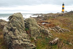
The area, which extends from the harbour village of
Killough southward includes many natural and manmade features, including the remains of a 19th Century Coast-guard station, at least three ruined early-Christian / Medieval churches, and a Souterrain of even more ancient lineage. The principal sites
544:
The cape extends approximately 2 miles south of
Killough into the Irish sea, separating Killough Harbour from Dundrum Bay, and is surrounded by water on three sides, and the rest of the larger Lecale peninsula to the north. It raises nowhere more than a few meters above sea level and is mostly given
968:
Throughout the 19th century, a series of improvements were made including converting the fuel source for the light to gas supplied from an on-site gas works. By far and away the most important of these alterations were carried out between 1891 and 1893, when the height of the tower was increased to
959:
The improvement of the nearby harbour at
Killough n the late 18th and early 19th centuries had hastened the need for a beacon at what had long been regarded as an exposed and treacherous part o the east-Ulster coast (see Harris above) Construction of the lighthouse was approved by the Ballast Board
979:
The daymark was changed to black with two yellow bands in 1954. The dwellings and the auxiliary light were provided with electricity. On 5 September 1957, the 084° bearing was altered to 078°. In this period, the lighthouse also established a curious connection with (then future) Irish playwright,
621:
The area was subject to considerable improvement in the 18th and 19th centuries as local coastal trade grew, and the need to protect passing vessels against local hazards become more acute, the lighthouse and coastguard station being built in this period, and both not long after the improvement of
1091:
In Autumn 1977, a small excavation was carried out which involved digging two trenches – one inside and one outside the north wall of the church, the purpose of which, amongst other things, being to determine whether
Wakeman's 1848 assertion that a burial ground surrounded the church with graves
654:
just down the coast from St. John's point on 22 September. There was no formal inquiry but her
Captain, James Hoken, is reported to have mistook the new St John's light for the Calf light on the Isle of Man, leading the then largest ship in the world to beach on the shore just west of St. John's
574:
While the provenance of the church is not known, historians speculate that it is unlikely that the stone church which is known to have existed since at least the 1100s was the first on the site, and it would have been unusual that such a structure would have sat alone, without a monastic site or
955:
Fully automated since 1981, the lighthouse has been painted black with two distinctive yellow bands since 1954, and operates a main light with a range of up to 29 miles (47 km), as well as auxiliary lights focused on warning passing craft of dangers in nearby
Dundrum Bay. In addition to
559:– Ballycam, Rossglass (part), Kilbride, and St. John's point – as well as elements of others. The formal townland of St. John's point encompasses only 1,284,384 m² or 317.38 acres, and thus a minority of the larger "St. John's point" area, ranking as 793rd largest townland in County Down.
1135:
in 1830, with the house being constructed for the couple at approximately the same time. Browne was instrumental in promoting marine safety in the area, partook in the rescue of several ships, and was instrumental in the building of the nearby lighthouse in the early 1840s.
1111:
A late-Georgian (early 1830s) country house of three-bays with canted ends, and accompanies by a series of later additions and out-building's, this substantial gentry residence opens onto the sea at its rear and, together with its large gate-screen, is listed as a class B1
990:
The former keepers' cottages and outbuildings have been operated by the Irish
Landmark Trust and operated as tourist accommodation since 2015, however, access to the lighthouse tower is generally restricted and only open to public access on a limited basis.
236:, being recorded here since at least 1170. A well-known beacon in the north-eastern Irish Sea, St. John's Point Lighthouse, built in 1844, sits near its southern tip and, at 40 m (130 ft), is the tallest lighthouse in Ireland (the
964:
laid the foundation stone. The station consisted of a white 45 foot high tower and two small houses. On 1 May 1844, the light was established with a range of 12 mi (19 km). The light was changed from white to red on 1 July 1860.
683:
to replace the 19th century
Fresnel lens atop the lighthouse with a modern, less bright LED equivalent, caused widespread disquiet in the local community, many of whom preferred the old light, according to then future MP for the area,
575:
settlement in the area. In terms of affiliation, O’Laverty wrote that ‘in early times both the church of
Rathmullan and the chapel of Saint John were appropriate to the order of St. John of Jerusalem’, suggesting that the church was a
1088:, meaning a hollow on a stone), often associated with holy wells and sacred spaces, rainwater collected there being used for sacred / healing purposes, albeit the use of this and other stones of this nature is not altogether clear.
662:. On 25 August 1847, she was floated free at a cost of £34,000 and taken back to Liverpool, but this expense exhausted the company's remaining reserves. After languishing in Prince's Dock, Liverpool for some time, she was sold to
669:
St. John's Point's importance in the local marine environment was attested to by the lighthouse's extension in the late 19th century and continued improvement, and, indeed, prior to her transfer to Southampton for fitting out,
696:, wrote to the then British and Irish Governments on the matter, as well as the Commissioners, and plans were subsequently abandoned with an alternative plan of investment in the lighthouse agreed instead.
721:
1053:
A pre-Romanesque church dating from as early as the 8th Century but more likely the 10th or 11th centuries, and now ruined, this is one of only a handful of examples in Ulster which survive from the
138:
960:
in 1839 (officially the Corporation for Preserving and Improving the Port of Dublin), with Capt. P. R. Browne, from a leading gentry family in the locale, acting as building contractor. The
948:
One of the county's best known landmarks, and rising over 40 meters above the rocky shore, St. John's point lighthouse is listed as one of twelve the "Great Lighthouses of Ireland" by the
598:. Its church sees continued reference through historic sources as it (and its lands, income, and tithes) are transferred through various monarchical decrees and settlements – for example,
1076:
Although ruined, the church retains some of the characteristic features of early stone churches, including the lintelled western door (which opens out onto panoramic views of the sea and
1065:(oak house) being the most popular form of early church in Ireland, while excavation in the 1970s (see below) seems to indicate the current structure succeeded another, older, building.
610:
to the Precentorship of Down, whilst at the dissolution of the monasteries, its tithes were (under the name 'St. Johnstown') were appropriated to the Preceptory of St. John in the Ards.
1147:, and after whose death in 1916 it was sold to a Mr. Bernard Kelly, who held it until 1949. The house was later owned and used as a residence for a number of years by prominent
1426:
972:
The early 20th century saw further refinements to the lighthouse and 1902, when three black bands were added to the tower. The gas burners were upgraded, and in 1908 an 920mm
693:
55:
1666:
1950:
2836:
998:
capital projects, with restoration and increased access works to be undertaken in the period 2021/2022 and encompassing a range of improvements including:
1367:
640:
The area received international intention for the first time when, in 1846 and during her second season of service and not long after embarking for
100:
71:
2846:
2790:
1874:
1766:
1471:
1096:
1045:
770:
1422:
2841:
1650:
1054:
567:
St. John's Point and the surrounding Lecale peninsula have been inhabited since pre-historic times, as attested to by the numerous
2031:
465:
20:
2704:
1219:
1189:
545:
over to agriculture with the majority of the land used for grazing cattle or arable production of crops, including potatoes.
594:
and under the control of the English of Ulster, and therefore not part of the lands further east subjected to the Jacobean
2795:
1894:
1697:
949:
865:
680:
132:
1595:
987:
The fog signal was discontinued on in January 2011 but the light is used during daylight hours when visibility is poor.
763:
248:
The area derives its name from the now ruined church of St. John the name of which is recorded in the Irish language as
2714:
1151:
1292:
1817:
1719:
1123:, it was named after Ms. Mary Jane Smyth, scion to an old established family in the area whose conformity with the
549:
2424:
2364:
2144:
1958:
1867:
1155:
2339:
629:
1139:
In 1864 the house passed to the founder's son, Major General Andrew Smythe Montague Browne, at which time the
2800:
2294:
2064:
1148:
599:
2629:
2429:
2419:
2314:
2299:
2008:
1993:
1903:
1744:
1127:
was supposed to have seen them rise in prominence. Ms. Smyth married to Peter Rutledge Montagu Browne, of
1061:
here, and it is suspected that the structure now visible may not have been the first on the site – wooden
663:
149:
2805:
2584:
2509:
2369:
2149:
1998:
1194:
1128:
750:
1321:
676:
conducted her sea trails in the Irish Sea and used Saint John's Light as a marker for those purposes.
2831:
2439:
2324:
2304:
2284:
1988:
1860:
1132:
995:
961:
926:
689:
651:
595:
934:
917:
902:
878:
2189:
2074:
1911:
829:
576:
19:
This article is about the body of land between Dundrum Bay and the Irish Sea. For other uses, see
2680:
2494:
2194:
1745:"ST. JOHN'S CHURCH, ST JOHN'S POINT CHURCH, JOHN'S WELL, ST. JOHN'S WELL, ST JOHN'S POINT CHURCH"
237:
658:
She remained aground for almost a year, protected by temporary measures organised by Brunel and
1847:
1643:
Killough : the church on the lough : aspects of village history and collected stories
1533:
2772:
2742:
2737:
2732:
2655:
2559:
1818:"ST. JOHN'S HOUSE (AKA JANEVILLE) 62 POINT ROAD ST. JOHN'S POINT KILLOUGH Downpatrick CO.DOWN"
1692:
1646:
1467:
1124:
1068:
731:
591:
1278:
See Great Britain Commissioners of the Public Records of Ireland. Foreword by M.C. Griffith.
2700:
2685:
2675:
2665:
2589:
2384:
1280:
Irish Patent Rolls of James I. Dublin Stationery Office for the Irish Manuscripts commission
1254:
1077:
994:
Following on from a consultation process in 2015, the lighthouse was selected as one of the
646:
633:
233:
221:
209:
153:
46:
555:
The area technically forming St. John's point encompasses all or substantial parts of four
2777:
2670:
1113:
1017:
Reduce the range of the light to 18 miles, as per 2010 and 2015 Aids to Navigation Reviews
582:
348:
331:
956:
night-time operation, the light is in use during daylight hours when visibility is poor.
363:
1507:
1491:
2810:
2645:
2604:
2469:
2449:
2354:
2139:
1179:
1081:
755:
607:
380:
201:
590:
By the early modern period, St. John's point and the surrounding area was part of the
2825:
2599:
2454:
2239:
2129:
1803:
Brannon, N.F. (1980) "A Trial Excavation at St. John's Point Church, County Down" in
1474:
981:
685:
659:
641:
650:
made a series of navigational errors that resulted in her being run hard aground in
2767:
2762:
2752:
2747:
2695:
2514:
2269:
2264:
2209:
2094:
1020:
Remove interior wall lining and expose the original masonry of the lighthouse tower
973:
1335:
2624:
2619:
2614:
2534:
2464:
2374:
2319:
2159:
2154:
2134:
2119:
2114:
2109:
2084:
2079:
2049:
2018:
2013:
1983:
1884:
1464:
Transatlantic: Samuel Cunard, Isambard Brunel, and the Great Atlantic Steamships
1184:
1161:
The house is currently in private ownership (on the market in 2021) and has the
1057:. The site is associated with Eoan, son of Cairland, who may have established a
746:
672:
217:
2727:
2722:
2660:
2650:
2594:
2554:
2529:
2524:
2519:
2504:
2499:
2479:
2474:
2409:
2349:
2259:
2214:
2204:
2184:
2169:
2124:
2104:
2089:
1978:
1842:
1563:
568:
399:
785:
772:
115:
102:
2757:
2609:
2579:
2549:
2544:
2459:
2434:
2394:
2389:
2344:
2329:
2279:
1968:
1963:
1058:
666:, former agents of the Great Western Steamship Company, for a mere £25,000.
229:
173:
1318:
An historical account of the Diocese of Down and Connor, ancient and modern
228:, which forms its northern extremity. The cape is mostly surrounded by the
2569:
2539:
2489:
2484:
2444:
2414:
2404:
2399:
2359:
2309:
2249:
2199:
2099:
2059:
2054:
2044:
2039:
952:, who operate it as one of the 65 active lighthouses on the Irish coast.
623:
556:
225:
1852:
2574:
2334:
2274:
2244:
2179:
2069:
2003:
1922:
1916:
1002:
Retain the use of the existing rotating historic lens and sweeping beam
1939:
548:
Several roads traverse the area, with the Rossglass Road (part of the
2564:
2379:
2289:
2254:
2234:
2229:
2224:
2219:
2174:
2164:
1973:
1174:
213:
163:
1214:
301:
Ecclesiastical taxation of the dioceses of Down, Connor, and Dromore
1928:
1396:. No. 19377. London. 26 October 1846. col F, A, pp. 4–5.
1067:
1044:
628:
581:
1368:"Speed and out of date maps led to stranding of SS Great Britain"
1856:
1820:. Northern Ireland Buildings Record - Department of Communities
1722:. Northern Ireland Buildings Record - Department of Communities
438:
The martyrology of Donegal: a calendar of the saints of Ireland
1508:"St John's Point lighthouse: Storm brews over planned changes"
1488:
Steam-ships: The story of their development to the present day
1938:
232:
and derives its name from a now ruined church dedicated to
1767:"St. John's Point Church, Document 3 (SM7-DOW-045-013-03)"
1720:"ST. JOHN'S POINT LIGHTHOUSE KILLOUGH Downpatrick CO.DOWN"
1026:
Reduce cost and maintenance requirements at the lighthouse
287:
Grant of Bishop Malachy to Abbatia Sancti Patricii in Down
1645:. Killough, Co. Down: Palatine Trust. 2000. p. 98.
1011:
Replace filament lamps (1,000 watts) with LED (90 watts)
1558:
1556:
1554:
1033:
The lighthouse remains in public ownership and has the
1337:
Ecclesiastical Antiquities of Down, Connor and Dromore
1023:
Provide opportunities for alternative use of buildings
1005:
Change the power system to mains with battery backup
2713:
2638:
2027:
1949:
1902:
1353:
The Antient and Present State of the County of Down
925:
910:
895:
890:
871:
861:
853:
845:
837:
822:
814:
806:
801:
762:
742:
412:Terrier or ledger book of Down and Connor, c. 1615
179:
169:
159:
145:
131:
30:
1029:Provide full range (18 mile) emergency lanterns
1843:The story of Irish Lights at Seafest – Youtube
1411:. No. 1847. Liverpool. 25 September 1846.
1095:The church is currently under the care of the
1868:
1772:. Northern Ireland Sites and Monuments Record
1747:. Northern Ireland Sites and Monuments Record
1244:, Institute of Irish Studies: Belfast, p. 128
8:
1622:
1620:
1618:
1616:
716:
1568:The Lighthouse Directory, UNC - Chapel Hill
451:Vultonia; Hibernis Cujgujlly; Anglis Vlster
431:Thigh Eóin i nUltoibh, Eóin, mac Carlain, ó
183:
35:
1875:
1861:
1853:
1154:, barrister, and founding chairman of the
1014:Retain auxiliary light with LED equivalent
933:
916:
914:25 nmi (46 km; 29 mi)
901:
877:
828:
754:
730:
715:
345:Gennerall discription or chart of Irelande
78:
27:
1452:. No. 250. London. 5 September 1847.
1072:Bullaun at St John's Church, October 2009
262:
1590:
1588:
1586:
1584:
1206:
571:and other ancient remains in the area.
552:) roughly forming its northern extent.
513:Register of Freeholders in County Down
178:
144:
64:
52:
1739:
1737:
1596:"St. John's Point (Co Down), History"
1502:
1500:
857:Black and Yellow bands, black lantern
168:
158:
130:
7:
1101:Sites and Monuments Record reference
2837:Seaside resorts in Northern Ireland
1669:St Johns Point Lighthouse, Co. Down
1259:Northern Ireland Place-Name Project
1143:appellation seems to have replaced
1097:Northern Ireland Environment Agency
1008:Remove mercury and diesel generator
533:A Dictionary of Ulster Place-Names
1423:"Recovery of the SS Great Britain"
1242:A Dictionary of Ulster Place-Names
1106:
644:, the then largest vessel afloat,
14:
1564:"Lighthouses of Northern Ireland"
1448:"Floating of the Great Britain".
1429:from the original on 2 April 2015
606:it was annexed by the charter of
474:St Hohn's Point als St Johnstowne
1792:A Hand-Book of Irish Antiquities
720:
466:Books of Survey and Distribution
77:
70:
54:
1450:Lloyd's Weekly London Newspaper
240:, though taller, is offshore).
2847:Peninsulas of Northern Ireland
1629:Buildings of South County Down
1220:Placenames Database of Ireland
1215:"Rinn Eoin/Saint John's Point"
1190:List of lighthouses in Ireland
875:Grade B1 listed building
705:of interest still intact are:
613:Writing in 1744 Harris stated:
586:East Ulster, late 15th century
224:, separating Dundrum Bay from
1:
1895:List of places in County Down
1805:Ulster Journal of Archaeology
1698:Commissioners of Irish Lights
1534:"St. John's Point Lighthouse"
1293:"Satin John's Point Townland"
1107:St. John's House or Janeville
1049:St. John's Church, West front
950:Commissioners of Irish Lights
899:37 m (121 ft)
866:Commissioners of Irish Lights
681:Commissioners of Irish Lights
636:stranded in Dundrum Bay, 1846
424:Irish patent rolls of James I
396:The Province Ulster described
60:Rocky shore facing South East
21:Saint John's (disambiguation)
2791:WikiProject Northern Ireland
1848:Great Lighthouses of Ireland
1538:Great Lighthouses of Ireland
1407:"The Great Britain Ashore".
16:Cape on the coast of Ireland
1366:D Armitage (28 July 2021).
579:institution at some point.
468:: Armagh, Down & Antrim
212:at the southern tip of the
2863:
1490:, Sidgwick & Jackson,
849:Cylindrical tapering Tower
717:St John's Point Lighthouse
708:
18:
2786:
1936:
1891:
1807:Vol. 43, 1980, pp.59 - 64
1334:Reeves, William. (1847).
942:
886:
738:
729:
655:point on the Down coast.
507:St Johnston in Rathmullan
96:
65:
53:
44:
2842:Landforms of County Down
1351:Harris, Walter. (1744).
1316:O'Laverty, James (1878)
1165:reference: HB18/10/044.
1035:Historic Building Number
379:Grant of James I to the
328:Ultoniae Orientalis Pars
2801:Northern Ireland Portal
2295:Drumlough, Hillsborough
1466:, HarperCollins:London
1240:McKay, Patrick (2007):
841:40 metres (130 ft)
664:Gibbs, Bright & Co.
307:Ballihione al Rinchione
2705:Islands of County Down
2300:Drumlough, Rathfriland
1943:
1790:Wakeman, W.F. (1848),
1673:. Irish Landmark Trust
1073:
1055:Early Christian Period
1050:
1040:
996:Irish Landmark Trust's
969:120 feet (37 m).
637:
619:
587:
406:St. Johane, Capella de
362:Irish patent rolls of
205:
184:
150:Newry, Mourne and Down
116:54.226113°N 5.659284°W
36:
2806:United Kingdom Portal
1942:
1462:Fox, Stephen (2003),
1409:Liverpool Mercury etc
1195:List of RNLI stations
1129:Westport, County Mayo
1071:
1048:
751:Down District Council
709:St. John's Lighthouse
632:
615:
585:
364:King James VI & I
314:Exchequer Inquisition
170:Offshore water bodies
1512:BBC Northern Ireland
1133:9th Regiment of Foot
1131:and enlisted in the
962:Marquis of Downshire
690:Member of Parliament
596:Plantation of Ulster
540:Geography and status
526:(St) John's townland
258:(Saint) John’s house
121:54.226113; -5.659284
2796:WikiProject Ireland
1486:Flether, A. (1910)
1119:Originally known as
1114:Protected Structure
782: /
726:
679:A 2015 plan by the
577:Knights Hospitaller
502:Reg. Deeds (Index)
491:Reg. Deeds (Index)
480:Reg. Deeds (Index)
316:(Down) 3 Ed. VI 17
294:Styoun, Ecclesia de
265:
112: /
2681:Lough Island Reavy
1944:
1693:"Capital Projects"
1627:Smith, P. (2020).
1340:. Dublin: p.33-34.
1125:established church
1074:
1051:
786:54.2262°N 5.6592°W
753:, United Kingdom
638:
588:
263:
238:Fastnet Lighthouse
194:Saint John's Point
133:Grid position
85:Saint John’s Point
32:Saint John’s Point
2819:
2818:
2773:Lordship of Newry
2738:Castlereagh Upper
2733:Castlereagh Lower
2656:Carlingford Lough
1472:978-0-06-019595-3
1425:. David Bremner.
1041:St. John's Church
946:
945:
931:Q(2) W 7.5s
592:Earldom of Ulster
537:
536:
520:(St) John's point
381:Cathedral of Down
191:
190:
2854:
2701:Strangford Lough
2691:St. John's Point
2676:Lecale peninsula
2666:Copeland Islands
1877:
1870:
1863:
1854:
1830:
1829:
1827:
1825:
1814:
1808:
1801:
1795:
1788:
1782:
1781:
1779:
1777:
1771:
1763:
1757:
1756:
1754:
1752:
1741:
1732:
1731:
1729:
1727:
1716:
1710:
1709:
1707:
1705:
1689:
1683:
1682:
1680:
1678:
1663:
1657:
1656:
1639:
1633:
1632:
1631:. Belfast: UAHS.
1624:
1611:
1610:
1608:
1606:
1592:
1579:
1578:
1576:
1574:
1560:
1549:
1548:
1546:
1544:
1530:
1524:
1523:
1521:
1519:
1504:
1495:
1484:
1478:
1460:
1454:
1453:
1445:
1439:
1438:
1436:
1434:
1419:
1413:
1412:
1404:
1398:
1397:
1389:
1383:
1382:
1380:
1378:
1363:
1357:
1356:
1355:. Dublin: p.134.
1348:
1342:
1341:
1331:
1325:
1320:Dublin: J Duffy
1314:
1308:
1307:
1305:
1303:
1289:
1283:
1276:
1270:
1269:
1267:
1265:
1251:
1245:
1238:
1232:
1231:
1229:
1227:
1211:
1163:Listed Buildings
1158:, Desmond Boal.
1141:St. John's House
1084:(from the Irish
1078:Mourne Mountains
938:
937:
921:
920:
906:
905:
882:
881:
833:
832:
797:
796:
794:
793:
792:
791:54.2262; -5.6592
787:
783:
780:
779:
778:
775:
758:
734:
727:
725:
724:
694:Margaret Ritchie
634:SS Great Britain
266:
226:Killough Harbour
222:Northern Ireland
214:Lecale peninsula
198:St. John's Point
187:
154:Northern Ireland
141:
127:
126:
124:
123:
122:
117:
113:
110:
109:
108:
105:
81:
80:
74:
58:
39:
28:
2862:
2861:
2857:
2856:
2855:
2853:
2852:
2851:
2822:
2821:
2820:
2815:
2782:
2709:
2703:
2671:Cranfield Point
2634:
2029:
2023:
1945:
1934:
1898:
1887:
1881:
1839:
1834:
1833:
1823:
1821:
1816:
1815:
1811:
1802:
1798:
1789:
1785:
1775:
1773:
1769:
1765:
1764:
1760:
1750:
1748:
1743:
1742:
1735:
1725:
1723:
1718:
1717:
1713:
1703:
1701:
1691:
1690:
1686:
1676:
1674:
1665:
1664:
1660:
1653:
1641:
1640:
1636:
1626:
1625:
1614:
1604:
1602:
1594:
1593:
1582:
1572:
1570:
1562:
1561:
1552:
1542:
1540:
1532:
1531:
1527:
1517:
1515:
1514:. 18 March 2015
1506:
1505:
1498:
1485:
1481:
1461:
1457:
1447:
1446:
1442:
1432:
1430:
1421:
1420:
1416:
1406:
1405:
1401:
1391:
1390:
1386:
1376:
1374:
1365:
1364:
1360:
1350:
1349:
1345:
1333:
1332:
1328:
1315:
1311:
1301:
1299:
1291:
1290:
1286:
1277:
1273:
1263:
1261:
1255:"Placenames NI"
1253:
1252:
1248:
1239:
1235:
1225:
1223:
1213:
1212:
1208:
1203:
1171:
1109:
1043:
976:was installed.
932:
915:
900:
876:
827:
790:
788:
784:
781:
776:
773:
771:
769:
768:
718:
714:
711:
702:
622:the harbour at
602:records how as
565:
542:
523:
389:St John's poynt
384:, AD 1609, 178
349:Baptista Boazio
332:Gerard Mercator
321:St. Johns Point
264:Historic Names
246:
137:
120:
118:
114:
111:
106:
103:
101:
99:
98:
92:
91:
90:
89:
88:
87:
86:
82:
61:
49:
40:
33:
24:
17:
12:
11:
5:
2860:
2858:
2850:
2849:
2844:
2839:
2834:
2824:
2823:
2817:
2816:
2814:
2813:
2811:Ireland Portal
2808:
2803:
2798:
2793:
2787:
2784:
2783:
2781:
2780:
2775:
2770:
2765:
2760:
2755:
2750:
2745:
2740:
2735:
2730:
2725:
2719:
2717:
2711:
2710:
2708:
2707:
2698:
2693:
2688:
2683:
2678:
2673:
2668:
2663:
2658:
2653:
2648:
2646:Ards Peninsula
2642:
2640:
2636:
2635:
2633:
2632:
2627:
2622:
2617:
2612:
2607:
2605:Tievenadarragh
2602:
2597:
2592:
2587:
2582:
2577:
2572:
2567:
2562:
2557:
2552:
2547:
2542:
2537:
2532:
2527:
2522:
2517:
2512:
2507:
2502:
2497:
2492:
2487:
2482:
2477:
2472:
2470:Magheraconluce
2467:
2462:
2457:
2452:
2450:Loughbrickland
2447:
2442:
2437:
2432:
2427:
2422:
2417:
2412:
2407:
2402:
2397:
2392:
2387:
2382:
2377:
2372:
2367:
2362:
2357:
2352:
2347:
2342:
2337:
2332:
2327:
2322:
2317:
2312:
2307:
2302:
2297:
2292:
2287:
2282:
2277:
2272:
2267:
2262:
2257:
2252:
2247:
2242:
2237:
2232:
2227:
2222:
2217:
2212:
2207:
2202:
2197:
2192:
2187:
2182:
2177:
2172:
2167:
2162:
2157:
2152:
2147:
2142:
2140:Ballynagarrick
2137:
2132:
2127:
2122:
2117:
2112:
2107:
2102:
2097:
2092:
2087:
2082:
2077:
2072:
2067:
2062:
2057:
2052:
2047:
2042:
2036:
2034:
2025:
2024:
2022:
2021:
2016:
2011:
2006:
2001:
1996:
1991:
1986:
1981:
1976:
1971:
1966:
1961:
1955:
1953:
1947:
1946:
1937:
1935:
1933:
1932:
1926:
1920:
1914:
1908:
1906:
1900:
1899:
1892:
1889:
1888:
1882:
1880:
1879:
1872:
1865:
1857:
1851:
1850:
1845:
1838:
1837:External links
1835:
1832:
1831:
1809:
1796:
1794:(Dublin, 1848)
1783:
1758:
1733:
1711:
1684:
1658:
1651:
1634:
1612:
1600:Irishlights.ie
1580:
1550:
1525:
1496:
1479:
1455:
1440:
1414:
1399:
1392:"(untitled)".
1384:
1358:
1343:
1326:
1309:
1284:
1271:
1246:
1233:
1205:
1204:
1202:
1199:
1198:
1197:
1192:
1187:
1182:
1180:Ards Peninsula
1177:
1170:
1167:
1108:
1105:
1082:Bullaun stones
1042:
1039:
1031:
1030:
1027:
1024:
1021:
1018:
1015:
1012:
1009:
1006:
1003:
944:
943:
940:
939:
929:
927:Characteristic
923:
922:
912:
908:
907:
897:
893:
892:
888:
887:
884:
883:
873:
869:
868:
863:
859:
858:
855:
851:
850:
847:
843:
842:
839:
835:
834:
824:
820:
819:
816:
812:
811:
808:
804:
803:
799:
798:
766:
760:
759:
744:
740:
739:
736:
735:
712:
710:
707:
701:
698:
564:
561:
541:
538:
535:
534:
531:
528:
515:
514:
511:
508:
504:
503:
500:
497:
493:
492:
489:
486:
482:
481:
478:
475:
471:
470:
462:
459:
455:
454:
448:
445:
444:St Johns poynt
441:
440:
435:
432:
428:
427:
421:
418:
414:
413:
410:
407:
403:
402:
398:, AD 1610, by
393:
390:
386:
385:
376:
373:
369:
368:
359:
356:
352:
351:
347:, AD 1599, by
342:
339:
338:St Johns hauen
335:
334:
325:
322:
318:
317:
311:
308:
304:
303:
298:
295:
291:
290:
284:
281:
277:
276:
273:
272:Reference date
270:
245:
242:
189:
188:
181:
177:
176:
171:
167:
166:
161:
157:
156:
147:
143:
142:
139:SB 61579 87339
135:
129:
128:
94:
93:
84:
83:
76:
75:
69:
68:
67:
66:
63:
62:
59:
51:
50:
45:
42:
41:
34:
31:
15:
13:
10:
9:
6:
4:
3:
2:
2859:
2848:
2845:
2843:
2840:
2838:
2835:
2833:
2830:
2829:
2827:
2812:
2809:
2807:
2804:
2802:
2799:
2797:
2794:
2792:
2789:
2788:
2785:
2779:
2776:
2774:
2771:
2769:
2766:
2764:
2761:
2759:
2756:
2754:
2751:
2749:
2746:
2744:
2741:
2739:
2736:
2734:
2731:
2729:
2726:
2724:
2721:
2720:
2718:
2716:
2712:
2706:
2702:
2699:
2697:
2694:
2692:
2689:
2687:
2684:
2682:
2679:
2677:
2674:
2672:
2669:
2667:
2664:
2662:
2659:
2657:
2654:
2652:
2649:
2647:
2644:
2643:
2641:
2637:
2631:
2628:
2626:
2623:
2621:
2618:
2616:
2613:
2611:
2608:
2606:
2603:
2601:
2598:
2596:
2593:
2591:
2588:
2586:
2583:
2581:
2578:
2576:
2573:
2571:
2568:
2566:
2563:
2561:
2558:
2556:
2553:
2551:
2548:
2546:
2543:
2541:
2538:
2536:
2533:
2531:
2528:
2526:
2523:
2521:
2518:
2516:
2513:
2511:
2508:
2506:
2503:
2501:
2498:
2496:
2493:
2491:
2488:
2486:
2483:
2481:
2478:
2476:
2473:
2471:
2468:
2466:
2463:
2461:
2458:
2456:
2455:Loughinisland
2453:
2451:
2448:
2446:
2443:
2441:
2438:
2436:
2433:
2431:
2428:
2426:
2423:
2421:
2418:
2416:
2413:
2411:
2408:
2406:
2403:
2401:
2398:
2396:
2393:
2391:
2388:
2386:
2383:
2381:
2378:
2376:
2373:
2371:
2368:
2366:
2363:
2361:
2358:
2356:
2353:
2351:
2348:
2346:
2343:
2341:
2338:
2336:
2333:
2331:
2328:
2326:
2323:
2321:
2318:
2316:
2313:
2311:
2308:
2306:
2303:
2301:
2298:
2296:
2293:
2291:
2288:
2286:
2283:
2281:
2278:
2276:
2273:
2271:
2268:
2266:
2263:
2261:
2258:
2256:
2253:
2251:
2248:
2246:
2243:
2241:
2240:Crawfordsburn
2238:
2236:
2233:
2231:
2228:
2226:
2223:
2221:
2218:
2216:
2213:
2211:
2208:
2206:
2203:
2201:
2198:
2196:
2193:
2191:
2188:
2186:
2183:
2181:
2178:
2176:
2173:
2171:
2168:
2166:
2163:
2161:
2158:
2156:
2153:
2151:
2148:
2146:
2143:
2141:
2138:
2136:
2133:
2131:
2130:Ballymacmaine
2128:
2126:
2123:
2121:
2118:
2116:
2113:
2111:
2108:
2106:
2103:
2101:
2098:
2096:
2093:
2091:
2088:
2086:
2083:
2081:
2078:
2076:
2073:
2071:
2068:
2066:
2063:
2061:
2058:
2056:
2053:
2051:
2048:
2046:
2043:
2041:
2038:
2037:
2035:
2033:
2026:
2020:
2017:
2015:
2012:
2010:
2007:
2005:
2002:
2000:
1997:
1995:
1992:
1990:
1987:
1985:
1982:
1980:
1977:
1975:
1972:
1970:
1967:
1965:
1962:
1960:
1957:
1956:
1954:
1952:
1948:
1941:
1930:
1927:
1924:
1921:
1918:
1915:
1913:
1910:
1909:
1907:
1905:
1901:
1897:
1896:
1890:
1886:
1878:
1873:
1871:
1866:
1864:
1859:
1858:
1855:
1849:
1846:
1844:
1841:
1840:
1836:
1819:
1813:
1810:
1806:
1800:
1797:
1793:
1787:
1784:
1768:
1762:
1759:
1746:
1740:
1738:
1734:
1721:
1715:
1712:
1700:
1699:
1694:
1688:
1685:
1672:
1670:
1662:
1659:
1654:
1652:0-9538528-0-6
1648:
1644:
1638:
1635:
1630:
1623:
1621:
1619:
1617:
1613:
1601:
1597:
1591:
1589:
1587:
1585:
1581:
1569:
1565:
1559:
1557:
1555:
1551:
1539:
1535:
1529:
1526:
1513:
1509:
1503:
1501:
1497:
1493:
1489:
1483:
1480:
1476:
1473:
1469:
1465:
1459:
1456:
1451:
1444:
1441:
1428:
1424:
1418:
1415:
1410:
1403:
1400:
1395:
1388:
1385:
1373:
1369:
1362:
1359:
1354:
1347:
1344:
1339:
1338:
1330:
1327:
1323:
1319:
1313:
1310:
1298:
1294:
1288:
1285:
1281:
1275:
1272:
1260:
1256:
1250:
1247:
1243:
1237:
1234:
1222:
1221:
1216:
1210:
1207:
1200:
1196:
1193:
1191:
1188:
1186:
1183:
1181:
1178:
1176:
1173:
1172:
1168:
1166:
1164:
1159:
1157:
1153:
1150:
1146:
1142:
1137:
1134:
1130:
1126:
1122:
1117:
1115:
1104:
1103:DOW 045:013.
1102:
1098:
1093:
1089:
1087:
1083:
1079:
1070:
1066:
1064:
1060:
1056:
1047:
1038:
1036:
1028:
1025:
1022:
1019:
1016:
1013:
1010:
1007:
1004:
1001:
1000:
999:
997:
992:
988:
985:
983:
982:Brendan Behan
977:
975:
970:
966:
963:
957:
953:
951:
941:
936:
930:
928:
924:
919:
913:
909:
904:
898:
894:
889:
885:
880:
874:
870:
867:
864:
860:
856:
852:
848:
844:
840:
836:
831:
825:
821:
818:granite tower
817:
813:
809:
805:
800:
795:
767:
765:
761:
757:
752:
748:
745:
741:
737:
733:
728:
723:
706:
699:
697:
695:
691:
687:
686:Chris Hazzard
682:
677:
675:
674:
667:
665:
661:
660:James Bremner
656:
653:
649:
648:
647:Great Britain
643:
635:
631:
627:
625:
618:
614:
611:
609:
605:
601:
597:
593:
584:
580:
578:
572:
570:
562:
560:
558:
553:
551:
546:
539:
532:
529:
527:
521:
517:
516:
512:
509:
506:
505:
501:
498:
496:St Johnstowne
495:
494:
490:
487:
485:St John's Qr.
484:
483:
479:
476:
473:
472:
469:
467:
463:
460:
458:St Johnstowne
457:
456:
453:, Joan Blaeu
452:
449:
446:
443:
442:
439:
436:
433:
430:
429:
425:
422:
419:
417:St Johnstowne
416:
415:
411:
408:
405:
404:
401:
397:
394:
391:
388:
387:
383:
382:
377:
374:
371:
370:
366:
365:
360:
357:
354:
353:
350:
346:
343:
340:
337:
336:
333:
329:
326:
323:
320:
319:
315:
312:
309:
306:
305:
302:
299:
296:
293:
292:
288:
285:
282:
279:
278:
274:
271:
268:
267:
261:
260:) in c.1170.
259:
255:
251:
243:
241:
239:
235:
231:
227:
223:
219:
215:
211:
207:
203:
199:
195:
186:
182:
175:
172:
165:
162:
155:
151:
148:
140:
136:
134:
125:
97:Coordinates:
95:
73:
57:
48:
43:
38:
29:
26:
22:
2768:Lecale Upper
2763:Lecale Lower
2753:Iveagh Upper
2748:Iveagh Lower
2696:Slieve Croob
2690:
2515:Newtownbreda
2425:Lawrencetown
2365:Hillsborough
2270:Donaghcloney
2265:Dollingstown
2210:Castlewellan
2145:Ballynahatty
2095:Ballyhalbert
1959:Ballynahinch
1893:
1822:. Retrieved
1812:
1804:
1799:
1791:
1786:
1774:. Retrieved
1761:
1749:. Retrieved
1724:. Retrieved
1714:
1702:. Retrieved
1696:
1687:
1675:. Retrieved
1668:
1661:
1642:
1637:
1628:
1603:. Retrieved
1599:
1571:. Retrieved
1567:
1541:. Retrieved
1537:
1528:
1516:. Retrieved
1511:
1494:, pp.225-226
1487:
1482:
1477:, pp.154–155
1463:
1458:
1449:
1443:
1431:. Retrieved
1417:
1408:
1402:
1393:
1387:
1375:. Retrieved
1371:
1361:
1352:
1346:
1336:
1329:
1317:
1312:
1300:. Retrieved
1297:Townlands.ie
1296:
1287:
1279:
1274:
1262:. Retrieved
1258:
1249:
1241:
1236:
1224:. Retrieved
1218:
1209:
1162:
1160:
1144:
1140:
1138:
1120:
1118:
1110:
1100:
1099:and has the
1094:
1090:
1085:
1075:
1062:
1052:
1037:HB18/10/048
1034:
1032:
993:
989:
986:
978:
974:Fresnel lens
971:
967:
958:
954:
947:
896:Focal height
815:Construction
703:
688:. The local
678:
671:
668:
657:
645:
639:
620:
616:
612:
603:
589:
573:
566:
554:
547:
543:
525:
519:
464:
450:
437:
423:
395:
378:
361:
355:St Johnstown
344:
327:
313:
300:
286:
257:
253:
249:
247:
197:
193:
192:
25:
2832:County Down
2625:Waringstown
2620:Waringsford
2615:Tullynakill
2535:Rathfriland
2465:Lurganville
2375:Katesbridge
2355:Helen's Bay
2340:Greencastle
2320:Gamblestown
2160:Ballywalter
2155:Ballyskeagh
2135:Ballymartin
2120:Ballylesson
2115:Ballykinler
2110:Ballyhornan
2085:Ballydargan
2080:Ballybannan
2050:Annsborough
2019:Warrenpoint
2014:Newtownards
1984:Downpatrick
1885:County Down
1492:Online Copy
1475:Online copy
1322:Online copy
1226:20 December
1185:Downpatrick
807:Constructed
789: /
764:Coordinates
747:County Down
673:RMS Titanic
652:Dundrum Bay
569:Souterrains
524:Baile Eoin
218:County Down
180:Native name
119: /
2826:Categories
2728:Ards Upper
2723:Ards Lower
2661:Cloughmore
2651:Burr Point
2595:Strangford
2555:Saintfield
2530:Poyntzpass
2525:Portavogie
2520:Portaferry
2505:Moneyslane
2500:Moneyreagh
2480:Mayobridge
2475:Magheralin
2410:Killyleagh
2350:Groomsport
2260:Derryneill
2215:Clandeboye
2205:Carrowdore
2185:Bryansford
2170:Blackskull
2125:Ballylough
2105:Ballyholme
2090:Ballygowan
2065:Aughnacloy
1979:Donaghadee
1883:Places in
1372:Newsletter
1201:References
826:1981
774:54°13′34″N
713:Lighthouse
518:Rinn Eoin
400:John Speed
289:, AD 1183
275:Reference
254:Teach Eoin
252:(Mod. Ir.
234:Saint John
104:54°13′34″N
2758:Kinelarty
2639:Landforms
2630:Whiterock
2610:Tullylish
2580:Sheeptown
2550:Rostrevor
2545:Ringhaddy
2460:Lurganare
2435:Legananny
2430:Legacurry
2420:Kircubbin
2395:Killinure
2390:Killinchy
2385:Kilcooley
2345:Greyabbey
2330:Gilnahirk
2315:Edenderry
2280:Drumaness
2032:townlands
2009:Newcastle
1994:Dundonald
1969:Carryduff
1964:Banbridge
1394:The Times
1145:Janeville
1121:Janeville
1063:dairthech
1059:monastery
823:Automated
777:5°39′33″W
557:townlands
426:14a 336a
250:Tech Eoin
244:Etymology
230:Irish Sea
206:Rinn Eoin
185:Rinn Eoin
174:Irish Sea
107:5°39′33″W
37:Rinn Eoin
2743:Dufferin
2715:Baronies
2585:Shrigley
2570:Seaforde
2540:Ravernet
2510:Monteith
2490:Millisle
2445:Lenaderg
2415:Kinallen
2405:Killowen
2400:Killough
2370:Hilltown
2360:Hillhall
2310:Dunnaval
2250:Crossgar
2200:Carnalea
2150:Ballynoe
2100:Ballyhay
2055:Ardglass
2045:Annalong
2040:Annahilt
2028:Villages
1999:Holywood
1704:2 August
1677:2 August
1605:2 August
1573:4 August
1543:2 August
1518:2 August
1427:Archived
1377:2 August
1302:2 August
1264:2 August
1169:See also
1149:Unionist
872:Heritage
862:Operator
854:Markings
743:Location
700:Features
642:New York
624:Killough
280:Stethian
146:Location
2686:Mournes
2600:Struell
2575:Seahill
2440:Leitrim
2335:Gransha
2325:Gilford
2305:Dundrum
2285:Drumbeg
2275:Dromara
2245:Cregagh
2180:Braniel
2070:Ballela
2060:Attical
2004:Kilkeel
1989:Dromore
1923:Lisburn
1917:Belfast
1824:25 July
1776:25 July
1751:25 July
1726:25 July
1433:24 July
1324:, p.155
1282:, 1966.
608:James I
563:History
208:) is a
160:Part of
2778:Mourne
2565:Scarva
2380:Kilcoo
2290:Drumbo
2255:Cultra
2235:Corbet
2230:Conlig
2225:Clough
2220:Cloghy
2190:Burren
2175:Bleary
2165:Benraw
2075:Balloo
1974:Comber
1931:(part)
1925:(part)
1919:(part)
1912:Bangor
1904:Cities
1649:
1470:
1175:Lecale
1086:buldán
838:Height
600:Reeves
367:; 14a
164:Lecale
2495:Moira
2195:Cabra
1951:Towns
1929:Newry
1770:(PDF)
911:Range
891:Light
846:Shape
802:Tower
719:
604:Stion
434:1630c
372:Stion
297:1306c
202:Irish
2560:Saul
2485:Maze
2030:and
1826:2021
1778:2021
1753:2021
1728:2021
1706:2021
1679:2021
1647:ISBN
1607:2021
1575:2021
1545:2021
1520:2021
1468:ISBN
1435:2021
1379:2021
1304:2021
1266:2021
1228:2023
810:1844
530:1999
510:1795
499:1708
488:1708
477:1708
461:1661
447:1654
420:1617
409:1615
392:1610
375:1609
358:1603
341:1599
324:1595
310:1549
283:1183
269:Form
210:cape
47:Cape
2590:Spa
1156:DUP
522:or
330:by
256:or
216:of
196:or
2828::
1736:^
1695:.
1615:^
1598:.
1583:^
1566:.
1553:^
1536:.
1510:.
1499:^
1370:.
1295:.
1257:.
1217:.
1152:MP
1116:.
749:,
692:,
626:.
550:A2
220:,
204::
152:,
1876:e
1869:t
1862:v
1828:.
1780:.
1755:.
1730:.
1708:.
1681:.
1671:"
1667:"
1655:.
1609:.
1577:.
1547:.
1522:.
1437:.
1381:.
1306:.
1268:.
1230:.
200:(
23:.
Text is available under the Creative Commons Attribution-ShareAlike License. Additional terms may apply.