539:
501:
348:
456:
301:
437:
395:
29:
526:
The river is very popular amongst locals especially in the summer months. The rivers winding path through rocky mountains has created numerous swimming holes along the rivers' length especially suited for swimming. The rivers mouth at the Pend d'Orielle (where it enters the reservoir formed by the
535:
Recreation Area known as the "Pend d'Oreille Valley
Wildlife Conservation Area" or the Pend d'Orielle Recreation Area. The area is popular for backcountry camping and swimming amongst locals.
538:
258:
80:
618:
1132:
262:
555:
321:
560:
515:
Once the South Salmo joins the main stem, the river turns west and flows for a few kilometres before finally discharging into the
478:(an annual electronic music festival that takes place at the end of July since 1998) is located on this portion of the riverbank.
410:
388:
520:
418:
500:
430:
449:
414:
380:
1102:
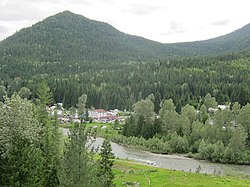
325:
426:
133:
333:
694:
467:
422:
602:
486:
482:
475:
368:
360:
329:
384:
494:
452:(historically known as the North Fork of the Salmo), which provides a large portion of the water in the river.
317:
270:
103:
460:
445:
341:
199:
406:
399:
376:
337:
305:
34:
585:
543:
509:
372:
289:
490:
471:
622:
516:
250:
119:
328:. The entire length of the river is 60 km and drains an area of 1,300 square kilometres.
313:
99:
645:
266:
60:
347:
455:
528:
356:
320:. The headwaters are south of Apex summit at the Nelson Nordic Ski Club, just south of
300:
285:
278:
274:
436:
1126:
1078:
1054:
1006:
982:
958:
910:
886:
862:
838:
790:
766:
718:
670:
580:
364:
254:
70:
814:
742:
277:
drainage basin, being a tributary of the Pend d'Oreille River, which flows into the
934:
394:
114:
505:
148:
135:
246:
1030:
288:
is 1,300 square kilometres (500 sq mi) in area. Its mean annual
532:
497:. The South Salmo river also contributes a lot of flow to the Salmo.
269:. The river is 60 km long and its source is 12 km south of
50:
340:) also runs alongside the river from its headwaters to the town of
537:
499:
454:
435:
393:
346:
299:
28:
481:
The river continues south to the southern junction of highways
355:
It flows south through the rugged mountains and forests of the
448:, itself named for the river. In Salmo the river is joined by
292:
is 32.5 cubic metres per second (1,150 cu ft/s).
273:
in the
Selkirk Mountains. The Salmo River is part of the
367:, joins the Salmo river just south of the turnoff from
332:
parallels the river for the rivers entire length. The
383:. The river then continues south to the community of
466:
South of the Salmo townsite, the river is joined by
359:, being joined by several creeks along its course.
225:
215:
205:
192:
184:
172:
164:
125:
113:
95:
86:
76:
66:
56:
46:
41:
21:
635:Search for Station 08NE074 Salmo River near Salmo
375:. From there it flows south to the community of
474:, a large ranch that is known as the site of
425:. Upon leaving Ymir, the river is joined by
351:Course of the Salmo River highlighted in red.
8:
598:
596:
605:, Northwest Power and Conservation Council
405:The river then flows south to the town of
603:Intermountain Subbasin Plan, Pend Oreille
621:. Water Survey of Canada. Archived from
572:
542:Salmo River at its confluence with the
231:382 m/s (13,500 cu ft/s)
211:31.8 m/s (1,120 cu ft/s)
18:
650:Salmo Watershed Streamkeepers Society
613:
611:
259:Regional District of Central Kootenay
81:Regional District of Central Kootenay
7:
221:1.64 m/s (58 cu ft/s)
695:"Nelson Salmo Great Northern Trail"
444:The river then reaches the town of
176:1,300 km (500 sq mi)
619:"Archived Hydrometric Data Search"
556:List of rivers of British Columbia
312:The Salmo River originates in the
14:
561:Tributaries of the Columbia River
334:Nelson-Salmo Great Northern Trail
1103:"Pend d'Oreille Recreation Area"
493:as that river flows west out of
344:, where the trail diverts west.
27:
127: • coordinates
1:
87:Physical characteristics
523:at the ghost town of Remac.
324:and very near the source of
521:Canada–United States border
194: • location
1149:
1133:Rivers of British Columbia
531:) is at the entrance to a
489:where it is joined by the
227: • maximum
217: • minimum
207: • average
504:Salmo River north of its
235:
180:
109:
91:
26:
1035:Shambhala Music Festival
495:Stagleap Provincial Park
476:Shambhala Music Festival
409:, where it is joined by
387:, where it is joined by
379:, where is it joined by
1079:"BC Geographical Names"
1055:"BC Geographical Names"
1007:"BC Geographical Names"
983:"BC Geographical Names"
959:"BC Geographical Names"
935:"BC Geographical Names"
911:"BC Geographical Names"
887:"BC Geographical Names"
863:"BC Geographical Names"
839:"BC Geographical Names"
815:"BC Geographical Names"
791:"BC Geographical Names"
767:"BC Geographical Names"
743:"BC Geographical Names"
719:"BC Geographical Names"
671:"BC Geographical Names"
546:
512:
463:
441:
402:
352:
338:Salmo-Troup Rail Trail
309:
306:Ymir, British Columbia
35:Ymir, British Columbia
586:BC Geographical Names
541:
503:
458:
440:Salmo River near Ymir
439:
397:
373:Whitewater Ski Resort
350:
303:
544:Pend d’Oreille River
517:Pend d'Oreille River
510:Pend d’Oreille River
433:, and Hidden Creek.
251:Pend d'Oreille River
120:Pend d’Oreille River
363:, which flows from
145: /
547:
519:just north of the
513:
464:
442:
431:Boulder Mill Creek
403:
353:
310:
168:60 km (37.3 miles)
149:49.033°N 117.383°W
646:"Watershed Facts"
625:on April 30, 2006
491:South Salmo River
472:Salmo River Ranch
314:Selkirk Mountains
263:Canadian province
239:
238:
100:Selkirk Mountains
77:Regional District
1140:
1117:
1116:
1114:
1113:
1099:
1093:
1092:
1090:
1089:
1075:
1069:
1068:
1066:
1065:
1051:
1045:
1044:
1042:
1041:
1027:
1021:
1020:
1018:
1017:
1003:
997:
996:
994:
993:
979:
973:
972:
970:
969:
955:
949:
948:
946:
945:
931:
925:
924:
922:
921:
907:
901:
900:
898:
897:
883:
877:
876:
874:
873:
859:
853:
852:
850:
849:
835:
829:
828:
826:
825:
811:
805:
804:
802:
801:
787:
781:
780:
778:
777:
763:
757:
756:
754:
753:
739:
733:
732:
730:
729:
715:
709:
708:
706:
705:
691:
685:
684:
682:
681:
667:
661:
660:
658:
657:
642:
636:
634:
632:
630:
615:
606:
600:
591:
590:
577:
459:Erie Creek near
326:Cottonwood Creek
308:, looking south.
267:British Columbia
228:
218:
208:
195:
160:
159:
157:
156:
155:
154:49.033; -117.383
150:
146:
143:
142:
141:
138:
61:British Columbia
31:
19:
1148:
1147:
1143:
1142:
1141:
1139:
1138:
1137:
1123:
1122:
1121:
1120:
1111:
1109:
1107:www.bchydro.com
1101:
1100:
1096:
1087:
1085:
1077:
1076:
1072:
1063:
1061:
1053:
1052:
1048:
1039:
1037:
1029:
1028:
1024:
1015:
1013:
1005:
1004:
1000:
991:
989:
981:
980:
976:
967:
965:
957:
956:
952:
943:
941:
933:
932:
928:
919:
917:
909:
908:
904:
895:
893:
885:
884:
880:
871:
869:
861:
860:
856:
847:
845:
837:
836:
832:
823:
821:
813:
812:
808:
799:
797:
789:
788:
784:
775:
773:
765:
764:
760:
751:
749:
741:
740:
736:
727:
725:
717:
716:
712:
703:
701:
693:
692:
688:
679:
677:
669:
668:
664:
655:
653:
644:
643:
639:
628:
626:
617:
616:
609:
601:
594:
579:
578:
574:
569:
552:
427:Porcupine Creek
398:Salmo River at
322:Cottonwood Lake
304:Salmo River in
298:
226:
216:
206:
193:
153:
151:
147:
144:
139:
136:
134:
132:
131:
128:
37:
33:Salmo River at
17:
16:River in Canada
12:
11:
5:
1146:
1144:
1136:
1135:
1125:
1124:
1119:
1118:
1094:
1083:apps.gov.bc.ca
1070:
1059:apps.gov.bc.ca
1046:
1022:
1011:apps.gov.bc.ca
998:
987:apps.gov.bc.ca
974:
963:apps.gov.bc.ca
950:
939:apps.gov.bc.ca
926:
915:apps.gov.bc.ca
902:
891:apps.gov.bc.ca
878:
867:apps.gov.bc.ca
854:
843:apps.gov.bc.ca
830:
819:apps.gov.bc.ca
806:
795:apps.gov.bc.ca
782:
771:apps.gov.bc.ca
758:
747:apps.gov.bc.ca
734:
723:apps.gov.bc.ca
710:
686:
675:apps.gov.bc.ca
662:
637:
607:
592:
571:
570:
568:
565:
564:
563:
558:
551:
548:
529:Seven Mile Dam
357:West Kootenays
297:
294:
286:drainage basin
279:Columbia River
275:Columbia River
257:region of the
237:
236:
233:
232:
229:
223:
222:
219:
213:
212:
209:
203:
202:
196:
190:
189:
186:
182:
181:
178:
177:
174:
170:
169:
166:
162:
161:
129:
126:
123:
122:
117:
111:
110:
107:
106:
97:
93:
92:
89:
88:
84:
83:
78:
74:
73:
68:
64:
63:
58:
54:
53:
48:
44:
43:
39:
38:
32:
24:
23:
15:
13:
10:
9:
6:
4:
3:
2:
1145:
1134:
1131:
1130:
1128:
1108:
1104:
1098:
1095:
1084:
1080:
1074:
1071:
1060:
1056:
1050:
1047:
1036:
1032:
1026:
1023:
1012:
1008:
1002:
999:
988:
984:
978:
975:
964:
960:
954:
951:
940:
936:
930:
927:
916:
912:
906:
903:
892:
888:
882:
879:
868:
864:
858:
855:
844:
840:
834:
831:
820:
816:
810:
807:
796:
792:
786:
783:
772:
768:
762:
759:
748:
744:
738:
735:
724:
720:
714:
711:
700:
696:
690:
687:
676:
672:
666:
663:
651:
647:
641:
638:
624:
620:
614:
612:
608:
604:
599:
597:
593:
588:
587:
582:
581:"Salmo River"
576:
573:
566:
562:
559:
557:
554:
553:
549:
545:
540:
536:
534:
530:
524:
522:
518:
511:
507:
502:
498:
496:
492:
488:
484:
479:
477:
473:
469:
462:
457:
453:
451:
447:
438:
434:
432:
428:
424:
420:
416:
412:
411:Stewart Creek
408:
401:
396:
392:
390:
389:Barrett Creek
386:
382:
378:
374:
370:
366:
365:Ymir Mountain
362:
358:
349:
345:
343:
339:
335:
331:
327:
323:
319:
315:
307:
302:
295:
293:
291:
287:
282:
280:
276:
272:
268:
264:
260:
256:
255:West Kootenay
252:
248:
244:
234:
230:
224:
220:
214:
210:
204:
201:
197:
191:
187:
183:
179:
175:
171:
167:
163:
158:
130:
124:
121:
118:
116:
112:
108:
105:
101:
98:
94:
90:
85:
82:
79:
75:
72:
71:West Kootenay
69:
65:
62:
59:
55:
52:
49:
45:
40:
36:
30:
25:
20:
1110:. Retrieved
1106:
1097:
1086:. Retrieved
1082:
1073:
1062:. Retrieved
1058:
1049:
1038:. Retrieved
1034:
1025:
1014:. Retrieved
1010:
1001:
990:. Retrieved
986:
977:
966:. Retrieved
962:
953:
942:. Retrieved
938:
929:
918:. Retrieved
914:
905:
894:. Retrieved
890:
881:
870:. Retrieved
866:
857:
846:. Retrieved
842:
833:
822:. Retrieved
818:
809:
798:. Retrieved
794:
785:
774:. Retrieved
770:
761:
750:. Retrieved
746:
737:
726:. Retrieved
722:
713:
702:. Retrieved
698:
689:
678:. Retrieved
674:
665:
654:. Retrieved
652:. 2013-03-11
649:
640:
627:. Retrieved
623:the original
584:
575:
525:
514:
480:
465:
443:
419:Quartz Creek
404:
354:
311:
284:The river's
283:
242:
240:
1031:"Our Story"
699:www.rdck.ca
629:October 19,
468:Sheep Creek
423:Oscar Creek
243:Salmo River
152: /
22:Salmo River
1112:2021-07-23
1088:2021-07-23
1064:2021-07-23
1040:2021-07-23
1016:2021-07-23
992:2021-07-23
968:2021-07-23
944:2021-07-23
920:2021-07-23
896:2021-07-23
872:2021-07-23
848:2021-07-23
824:2021-07-23
800:2021-07-23
776:2021-07-23
752:2021-07-23
728:2021-07-23
704:2021-07-23
680:2021-07-23
656:2021-07-22
567:References
506:confluence
450:Erie Creek
415:Ymir Creek
385:Porto Rico
381:Hall Creek
361:Apex Creek
173:Basin size
508:with the
369:Highway 6
330:Highway 6
316:south of
290:discharge
247:tributary
185:Discharge
102:south of
1127:Category
550:See also
533:BC Hydro
140:117°23′W
57:Province
42:Location
261:in the
253:in the
249:of the
47:Country
470:. The
318:Nelson
296:Course
271:Nelson
188:
165:Length
137:49°2′N
104:Nelson
96:Source
67:Region
51:Canada
461:Salmo
446:Salmo
342:Salmo
245:is a
200:Salmo
198:Near
115:Mouth
631:2008
485:and
429:and
421:and
407:Ymir
400:Hall
377:Hall
371:for
241:The
265:of
1129::
1105:.
1081:.
1057:.
1033:.
1009:.
985:.
961:.
937:.
913:.
889:.
865:.
841:.
817:.
793:.
769:.
745:.
721:.
697:.
673:.
648:.
610:^
595:^
583:.
417:,
413:,
391:.
281:.
1115:.
1091:.
1067:.
1043:.
1019:.
995:.
971:.
947:.
923:.
899:.
875:.
851:.
827:.
803:.
779:.
755:.
731:.
707:.
683:.
659:.
633:.
589:.
487:6
483:3
336:(
Text is available under the Creative Commons Attribution-ShareAlike License. Additional terms may apply.