49:
29:
56:
397:
runs on the
Nehalem and the Salmonberry prefer that the track along the Salmonberry remain closed. Of particular concern are landslides and herbicide spraying along the railway tracks in the river's
378:
to the mouth of the
Salmonberry. The train to the Salmonberry is part of an excursion-train network operated by the OCSR, a non-profit organization run by volunteers, on track formerly used by the
696:
701:
386:. The railway track continues up the Salmonberry for 14 miles (23 km), but flooding and erosion damaged it so severely that it was closed in 2007.
516:
379:
48:
349:, and flows west-northwest through the mountains, joining the Nehalem from the southeast about 15 miles (24 km) northeast of the city of
583:
495:
440:
225:
625:
375:
383:
34:
160:
323:
146:
334:. The river runs through part of the region devastated between 1933 and 1951 by a series of wildfires known as the
691:
617:
346:
410:
342:
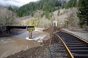
113:
435:
706:
604:
549:
327:
142:
523:
28:
390:
621:
599:
579:
491:
358:
77:
609:
331:
350:
335:
641:
685:
398:
394:
315:
211:
93:
374:, the Oregon Coast Scenic Railroad (OCSR), travels up the Nehalem River canyon from
464:
371:
663:
206:
517:"Proposing Solutions to the Landslide-Prone Railroad on the Salmonberry River"
578:(5th ed.). Santa Barbara, California: Benchmark Maps. 2012. p. 34.
240:
227:
175:
162:
613:
319:
103:
401:. Both kinds of incursion can harm fish and incubating fish eggs.
322:
in the United States. It drains a remote unpopulated area of the
556:. Portland State University and the Oregon Historical Society
490:. Corvallis: Oregon State University Press. pp. 83–84.
393:
and other conservation groups concerned about salmon and
445:. United States Geological Survey. November 28, 1980
63:
356:The river's name comes from the salmonberry plant,
294:
286:
274:
266:
256:
217:
205:
191:
152:
136:
128:
119:
109:
99:
89:
84:
71:
21:
318:, about 20 miles (32 km) long, in northwest
330:about 65 miles (105 km) west-northwest of
522:. The Wild Salmon Center. 2008. Archived from
511:
509:
507:
8:
666:. Oregon Coast Scenic Railroad. May 9, 2014
644:. Oregon Coast Scenic Railroad. May 5, 2014
55:
481:
479:
477:
475:
473:
422:
430:
428:
426:
33:The Salmonberry River and the damaged
18:
467:search using GNIS source coordinates.
7:
300:350 cu ft/s (9.9 m/s)
697:Rivers of Washington County, Oregon
602:; Lewis L. McArthur, eds. (1992) .
441:Geographic Names Information System
702:Rivers of Tillamook County, Oregon
14:
576:Oregon Road and Recreation Atlas
278:66 sq mi (170 km)
54:
47:
27:
642:"Oregon Coast Scenic Railroad"
463:Source elevation derived from
384:Port of Tillamook Bay Railroad
219: • coordinates
154: • coordinates
35:Port of Tillamook Bay Railroad
16:River in Oregon, United States
1:
120:Physical characteristics
488:Field Guide to Oregon Rivers
258: • elevation
193: • elevation
324:Northern Oregon Coast Range
147:Northern Oregon Coast Range
138: • location
723:
296: • average
197:2,090 ft (640 m)
618:Oregon Historical Society
380:Southern Pacific Railroad
370:An excursion railway and
341:It rises in northeastern
304:
282:
201:
124:
42:
26:
411:List of rivers of Oregon
605:Oregon Geographic Names
345:, near its border with
270:20 mi (32 km)
262:236 ft (72 m)
328:Tillamook State Forest
314:is a tributary of the
241:45.75083°N 123.65333°W
176:45.74556°N 123.39278°W
143:Tillamook State Forest
620:Press. p. 738.
529:on November 29, 2014
486:Palmer, Tim (2014).
246:45.75083; -123.65333
181:45.74556; -123.39278
554:Oregon Encyclopedia
436:"Salmonberry River"
237: /
172: /
75:Salmonberry plant,
600:McArthur, Lewis A.
391:Wild Salmon Center
585:978-0-929591-62-9
497:978-0-87071-627-0
359:Rubus spectabilis
347:Washington County
312:Salmonberry River
308:
307:
78:Rubus spectabilis
22:Salmonberry River
714:
692:Rivers of Oregon
676:
675:
673:
671:
660:
654:
653:
651:
649:
638:
632:
631:
608:(6th ed.).
596:
590:
589:
572:
566:
565:
563:
561:
550:"Tillamook Burn"
545:
539:
538:
536:
534:
528:
521:
513:
502:
501:
483:
468:
461:
455:
454:
452:
450:
432:
343:Tillamook County
297:
252:
251:
249:
248:
247:
242:
238:
235:
234:
233:
230:
194:
187:
186:
184:
183:
182:
177:
173:
170:
169:
168:
165:
155:
139:
58:
57:
51:
37:in February 2008
31:
19:
722:
721:
717:
716:
715:
713:
712:
711:
682:
681:
680:
679:
669:
667:
662:
661:
657:
647:
645:
640:
639:
635:
628:
598:
597:
593:
586:
574:
573:
569:
559:
557:
547:
546:
542:
532:
530:
526:
519:
515:
514:
505:
498:
485:
484:
471:
462:
458:
448:
446:
434:
433:
424:
419:
407:
368:
295:
259:
245:
243:
239:
236:
231:
228:
226:
224:
223:
220:
192:
180:
178:
174:
171:
166:
163:
161:
159:
158:
153:
137:
67:
66:
65:
64:
61:
60:
59:
38:
17:
12:
11:
5:
720:
718:
710:
709:
707:Tillamook Burn
704:
699:
694:
684:
683:
678:
677:
655:
633:
626:
591:
584:
567:
548:Decker, Doug.
540:
503:
496:
469:
456:
421:
420:
418:
415:
414:
413:
406:
403:
399:riparian zones
367:
364:
336:Tillamook Burn
306:
305:
302:
301:
298:
292:
291:
288:
284:
283:
280:
279:
276:
272:
271:
268:
264:
263:
260:
257:
254:
253:
221:
218:
215:
214:
209:
203:
202:
199:
198:
195:
189:
188:
156:
150:
149:
140:
134:
133:
130:
126:
125:
122:
121:
117:
116:
111:
107:
106:
101:
97:
96:
91:
87:
86:
82:
81:
73:
69:
68:
62:
53:
52:
46:
45:
44:
43:
40:
39:
32:
24:
23:
15:
13:
10:
9:
6:
4:
3:
2:
719:
708:
705:
703:
700:
698:
695:
693:
690:
689:
687:
665:
659:
656:
643:
637:
634:
629:
627:0-87595-236-4
623:
619:
615:
611:
607:
606:
601:
595:
592:
587:
581:
577:
571:
568:
555:
551:
544:
541:
525:
518:
512:
510:
508:
504:
499:
493:
489:
482:
480:
478:
476:
474:
470:
466:
460:
457:
444:
442:
437:
431:
429:
427:
423:
416:
412:
409:
408:
404:
402:
400:
396:
392:
387:
385:
381:
377:
373:
365:
363:
361:
360:
354:
352:
348:
344:
339:
337:
333:
329:
325:
321:
317:
316:Nehalem River
313:
303:
299:
293:
289:
285:
281:
277:
273:
269:
265:
261:
255:
250:
222:
216:
213:
212:Nehalem River
210:
208:
204:
200:
196:
190:
185:
157:
151:
148:
144:
141:
135:
131:
127:
123:
118:
115:
112:
108:
105:
102:
98:
95:
94:United States
92:
88:
83:
80:
79:
74:
70:
50:
41:
36:
30:
25:
20:
670:November 15,
668:. Retrieved
658:
648:November 15,
646:. Retrieved
636:
603:
594:
575:
570:
560:November 15,
558:. Retrieved
553:
543:
531:. Retrieved
524:the original
487:
465:Google Earth
459:
447:. Retrieved
439:
388:
372:dinner train
369:
357:
355:
340:
311:
309:
76:
244: /
232:123°39′12″W
179: /
167:123°23′34″W
686:Categories
664:"About Us"
417:References
275:Basin size
229:45°45′03″N
164:45°44′44″N
533:April 29,
449:April 28,
395:steelhead
287:Discharge
114:Tillamook
72:Etymology
610:Portland
405:See also
382:and the
366:Railroad
332:Portland
85:Location
376:Wheeler
351:Nehalem
326:in the
90:Country
624:
614:Oregon
582:
494:
443:(GNIS)
320:Oregon
290:
267:Length
132:
129:Source
110:County
104:Oregon
527:(PDF)
520:(PDF)
207:Mouth
100:State
672:2014
650:2014
622:ISBN
580:ISBN
562:2014
535:2012
492:ISBN
451:2012
389:The
310:The
688::
616::
612:,
552:.
506:^
472:^
438:.
425:^
362:.
353:.
338:.
145:,
674:.
652:.
630:.
588:.
564:.
537:.
500:.
453:.
Text is available under the Creative Commons Attribution-ShareAlike License. Additional terms may apply.